Download Agreement, Release, and Acknowledgement of Risk:
You (the person requesting this file download) fully understand mountain climbing ("Activity") involves risks and dangers of serious bodily injury, including permanent disability, paralysis, and death ("Risks") and you fully accept and assume all such risks and all responsibility for losses, costs, and damages you incur as a result of your participation in this Activity.
You acknowledge that information in the file you have chosen to download may not be accurate and may contain errors. You agree to assume all risks when using this information and agree to release and discharge 14ers.com, 14ers Inc. and the author(s) of such information (collectively, the "Released Parties").
You hereby discharge the Released Parties from all damages, actions, claims and liabilities of any nature, specifically including, but not limited to, damages, actions, claims and liabilities arising from or related to the negligence of the Released Parties. You further agree to indemnify, hold harmless and defend 14ers.com, 14ers Inc. and each of the other Released Parties from and against any loss, damage, liability and expense, including costs and attorney fees, incurred by 14ers.com, 14ers Inc. or any of the other Released Parties as a result of you using information provided on the 14ers.com or 14ers Inc. websites.
You have read this agreement, fully understand its terms and intend it to be a complete and unconditional release of all liability to the greatest extent allowed by law and agree that if any portion of this agreement is held to be invalid the balance, notwithstanding, shall continue in full force and effect.
By clicking "OK" you agree to these terms. If you DO NOT agree, click "Cancel"...
This was my 3rd time trying to ski Culebra. First time I tried in February of 2016, but had to leave the skis at the big cairn. Due to high winds and sparse coverage, the skiing would not have been fun. Then I tried to schedule the ski in the spring of 2019 after skiing Kit Carson and Challenger, but got a food poisoning. At that time, I was still thinking to ski the standard ridge route. However, in July of 2019 I hiked 13ers Maxwell & Co and was stunned to see a beautiful north face of Culebra from a distance - still hanging in strong after that big snow year.
Windy, dry Culebra, February'16. Dr Jon skied the ridge the day before me.
Snow on Culebra, July'19 as seen from Maxwell
So when a Facebook group formed this winter to ski Culebra, I got mildly excited. 2021 was shaping up a low snow year, and Culebra needs 2019 levels to be legitimately skiable. We picked the weekend of April 4th, which should be the height of the snowpack and made our reservations with the ranch. On April 4th, we started from the ranch HQ as a diverse group of 10 around 6.30am. The road was still snowy all the way up to the 4 way. Snow continued to the large cairn. Once I got to the cairn, the ridge looked dry again, but I could see a sliver of snow from Culebra summit. False summit also had a sizeable snowfield. I pressed to the summit and arrived just after 12 pm.
Dry ridge on Culebra, but a sliver of snow on the north faceSummit ~12 pm
The rest of the group was still coming up, and the guy ahead of me already departed. I set to figure out the descent. I could see a couple options. The easier Option 1 to the skiers' right required a downclimb on dry rock, and I wasn't sure about the exit below. Option 2, although steeper, had a cleaner entrance and the cliffband at the bottom looked friendlier on the topo.
Option 1Option 2, just to the left of the summit
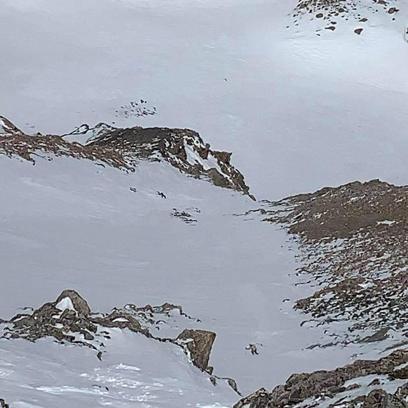
Option 2 looked tricky getting into the line on what it looked like winter snowpack. Nobody in the group had expressed interest in this more involved north face descent, so I was on my own. As I was worried about wet slides on the descent (avy level was Orange that day), I didn't stay too long on the summit. First couple hundred feet involved shenanigans such as kicksteps and traversing, with an occasional jumpturn. Once I got into the line proper, it was smooth sailing, well, until I found myself above the cliff! Had to traverse to the left on skis, but then hiked down maybe 30 ft on dry rock. In a bigger snow year this would probably fill in just fine.
Initial section, with the group cheering me from the summitDropping into the gullySmooth sailing, but approaching the cliff band below
Line topoNorth face overview
The lower basin also had some fun features and a few pockets of steepness. My original plan was to make the reclimb back to the cairn (and I was regretting it half way up due to my early season lack of fitness, 6k ft off the couch is a lot!), but I could have skied out the Corneros lake drainage if the snow had been total slush on the upclimb or if the weather was stormy. I just wasn't sure about the snow quality in the basin at that late afternoon hour, and my sense of exploration was waning. To my surprise, 4-5 people from my group dropped in from Culebra shoulder by the cairn just as I was booting up, enjoying hero corn and took the Corneros lake exit. They reported postholing through the soft snow (on skis!) to get to the 4-way and ended up half an hour late to the 6pm check-out time at the ranch, and were fined $100 each as per waiver. So that's something to consider. There's no easy solution to get out of that drainage, and watch your timing.
Enjoying great corn before a rough exit4 way intersection
Once back at the cairn, the descent was fairly swift and straightforward, and I made it back to the ranch with an hour to spare. Still, a long day on Culebra.
My GPS Tracks on Google Maps (made from a .GPX file upload):
View on the Map
GPX file cannot be downloaded (per author)
Thumbnails for uploaded photos (click to open slideshow):
Caution: The information contained in this report may not be accurate and should not be the only resource used in preparation for your climb. Failure to have the necessary experience, physical conditioning, supplies or equipment can result in injury or death. 14ers.com and the author(s) of this report provide no warranties, either express or implied, that the information provided is accurate or reliable. By using the information provided, you agree to indemnify and hold harmless 14ers.com and the report author(s) with respect to any claims and demands against them, including any attorney fees and expenses. Please read the 14ers.com Safety and Disclaimer pages for more information.
Please respect private property: 14ers.com supports the rights of private landowners to determine how and by whom their land will be used. In Colorado, it is your responsibility to determine if land is private and to obtain the appropriate permission before entering the property.


")


