| Peak(s): |
Crystal Peak - 13,860 feet |
| Date Posted: | 02/04/2021 |
| Date Climbed: | 08/15/2020 |
| Author: | Chelsea |
| Additional Members: | 13erRetriever, torimeri |
| Peak(s): |
Crystal Peak - 13,860 feet |
| Date Posted: | 02/04/2021 |
| Date Climbed: | 08/15/2020 |
| Author: | Chelsea |
| Additional Members: | 13erRetriever, torimeri |
| Smoky Crystal |
|---|
|
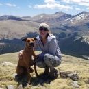
Crystal Peak A (13,852′) 08/15/20 | 5.22 miles | 1,956′ gain | Class 2  The summer of 2020 was a particularly bad wildfire season in Colorado with the three biggest wildfires in the state’s history all occurring within just a few months. So far we hadn’t been horribly affected by smoke, but this hike marked a noticeable change for the worse both on hikes and at home. The prominent haze in many of my pictures may look like poor picture quality but it’s actually thick smoke. Allie picked a trio of 13ers (Crystal Peak, Peak 10, and Peak 9) to hit her peaks #98, 99, and 100. Her parents came with to help celebrate and Tori tagged along as well. It’s not very often we have such a big group! Tori and I met Allie and her parents at the 2wd trailhead where we caravanned up the 4wd road to Lower Crystal Lake. 
The road to Lower Crystal Lake is a stiff 4wd. Both the high clearance and 4-lo of the Tacoma were needed in some sections. Towards the top the road is overgrown and the shrubs scratched up the sides of the truck. (Oops…thankfully this was all superficial and we were able to get this buffed out before Klay took his truck back.) There was room for a handful of vehicles at the lake. Parking this high cut off ~4.25 miles and 1,500′ of hiking. A trail starts at Lower Crystal Lake and switchbacks up the hillside, eventually making its way to Upper Crystal Lake. Just like in many other areas of Colorado, the trails and roads in this area were originally used by miners in their search for metals like gold and silver. 


 We decided to do Crystal Peak first since it’s the tallest. Just before Upper Crystal Lake, we cut off the trail and hiked up talus and grass to the Crystal/Peak 10 saddle.  


After a quick break at the saddle, we continued up Crystal’s northeast ridge. There were often trail fragments through the talus.  


The ridge went by quickly and we soon found ourselves at the summit with a handful of others, all of whom had ascended different routes. Tori’s asthma had been acting up due to the smoke, which didn’t seem to want to go away. 


Unfortunately Tori’s asthma didn’t show signs of improvement after a long rest. We decided it would be safer to head back down to the trailhead instead of finishing the trio of peaks. 


We parted ways at the saddle, Allie and her parents heading up Peak 10 and Tori and I retracing our steps back to the truck. Since we’d driven separately, the rest of the group was still able to finish the loop and Allie made it to peak #100! Tori and I maintained a slow pace so as to not make her asthma any worse. Now that I’d been in smoky conditions for a few hours, my body was feeling the effects as well. It was definitely time to get down to fresher air. 
Our drive out was straightforward and I was thankful we didn’t have any difficulty passing other vehicles. We got a lot of funny looks from hikers and backpackers. Maybe they didn’t know driving was an option? Even with the smoke (and only getting one peak instead of our planned three) it’s always a good day in the mountains and we were lucky to experience it. Tori recovered just fine and was ready to hike with me again the following week, thankfully in a less smoky area. Thumbnails for uploaded photos (click to open slideshow): 


 rising behind")

")


")


")
")

 and Peak 10 (13,633′)")
, Quandary Peak (14,265′, further peak on the left)")


")
|
| Comments or Questions | ||||||
|---|---|---|---|---|---|---|
|
Caution: The information contained in this report may not be accurate and should not be the only resource used in preparation for your climb. Failure to have the necessary experience, physical conditioning, supplies or equipment can result in injury or death. 14ers.com and the author(s) of this report provide no warranties, either express or implied, that the information provided is accurate or reliable. By using the information provided, you agree to indemnify and hold harmless 14ers.com and the report author(s) with respect to any claims and demands against them, including any attorney fees and expenses. Please read the 14ers.com Safety and Disclaimer pages for more information.