| Report Type | Full |
| Peak(s) |
San Luis Peak - 14,023 feet |
| Date Posted | 01/01/2021 |
| Date Climbed | 12/26/2020 |
| Author | JtheChemE |
| Additional Members | brerrabbit, aholle88 |
| Catching a Break on a Winter San Luis: December 2020 |
|---|
|
San Luis Peak – December 26th 2020 Team: Andrew, Garrett Winter 2020 has been off to a slow start, as snow has been particularly touchy given the snow/weather pattern heading to the solstice. With that in mind, conservative routes are the name of the game, so plans shifted to San Luis Peak. With an excellent weather window on Christmas, I floated the idea to Andrew and Garrett and they were on board. Garrett had already done San Luis in winter, but was happy to lend some support to this attempt. Thanks buddy! We intended to manage the snow conditions by taking the continental divide route, therby avoiding questionable terrain dropping in towards the winter variation of San Luis. Christmas morning came and went, and soon I was driving to Creede to catch a full rest before a 4:30 start time on the 26th. We had planned to take a variation on the southwest shoulder of 13,285 that stayed on public lands, which would significantly decrease the distance versus taking the road towards San Luis pass. However, a last minute discussion at the parking area and we all agreed to take the road given the strong snowmobile track. The extra miles would be easy on the road, or spent on the scoured ridge. The approach to 11,600’ goes by fast and easy since the road is super tracked by sleds. We didn't have to put on snowshoes until the Equity Mine gate, after which we have the remains of a snowshoe track from 12/21 (thanks, druid2112). The first real trenching of the day started at 11,600 on up towards Southeast San Luis Pass Peak, but it was minimal. Approaches aren’t supposed to be this easy! This unexpectedly cruiser approach felt like a nice bit of good fortune to start our day. We were hoping luck would stay on our side for the long ridge and scrambly bits along the divide. 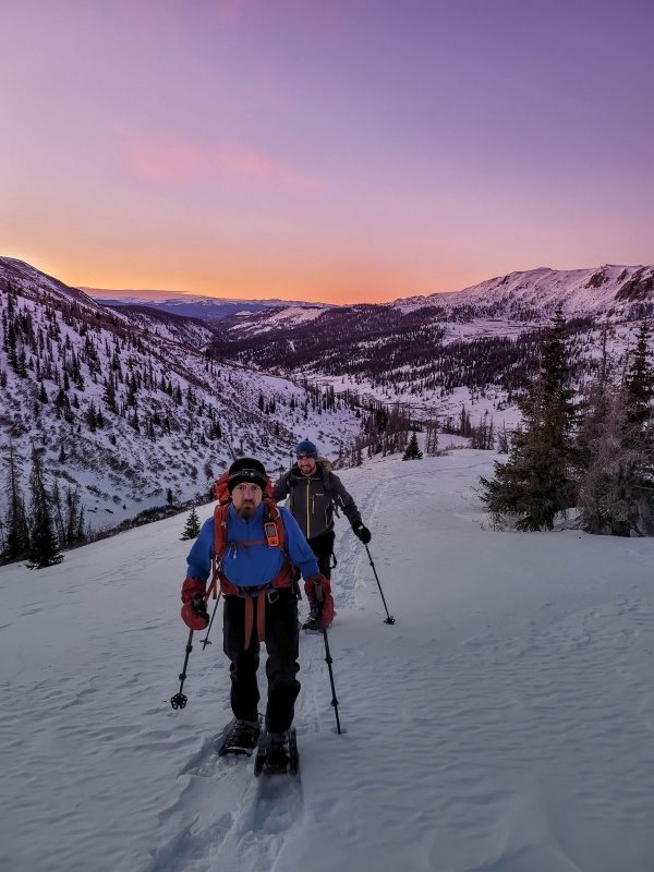
However, once we reached the saddle an looked on to San Luis we had another good bit of luck. There had obviously been significant melt on Christmas Day, coupled with strong wind scouring since the 21st beta. The net effect was an easy decision to forgo the Continental Divide route, and suss out safe passage via the more standard winter route. I’ve heard the saying “Christmas came early” but in our case this gift was a day late! 
That said, we still needed to take care managing small terrain features, and avoid proximity to big open slopes given all of the recent field reports regarding remotely triggered slides. 
Dropping off the pass is initially low angle, but to get down to the Spring Creek drainage we opted for a steep sidehill just north of the obvious ravine running down from the pass to the drainage since this was either dry, or only a very thin cohesionless layer of snow. 

About halfway down this ravine the cohesionless powder gave way to a stiff slab over willows. To avoid this, we were forced to cross over to the south side and descend through dense timber. This was slow goings, because the snow was DEEP in the trees. Trenching downhill through this portion may even have been the crux of the day! There were many downed trees, which further slowed things, especially given my 30” snowshoes are not particularly nimble. 
Andrew was leading the charge down, and once we reached spring creek he quickly found a trench(?!). Sure enough, some critter had been kind enough to plow a ~12” trench for us to reinforce. We weren’t quite sure what animal it was, but we came to the conclusion it could have been a moose. In any case, we weren’t going to look a gift horse in the mouth (gift moose, I suppose), and for the time being the trench was heading where we wanted to go. So, we followed it rather than plow our own. This was our third lucky break on the day, because this lower angle terrain in the drainage held deep and unsupportive snow. Any step off the moose track resulted in powder to the knees or higher. We kept chugging, and our luck continued as the moose track followed exactly the best contour to our preferred line up the west side San Luis. So it was at 10:00am, that we found ourselves caching our snowshoes for the grunt up a west rib of San Luis. 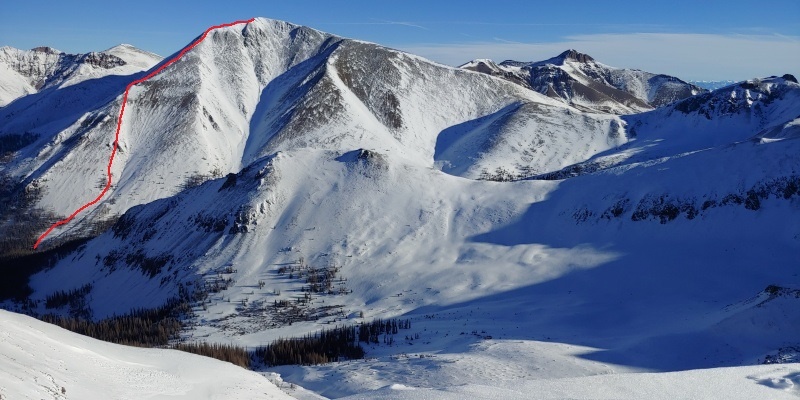


This west rib/face variation was STEEP as It gains ~2900’ over ~1 mile. We tried to stick to kicking steps in whatever thin snow coverage we could find, since the lower portion of our route was slip-n-slide talus.There was a brief scrambly section that added a bit of interest to the route, but other than that there wasn’t much to it for us. More snow would certainly change the character of this route, so YMMV. 

We summited at ~12, and took in the views on a great, bluebird day. 


The way out was mostly pleasant, although regaining ~1200’ on the way out was sort of a bummer. 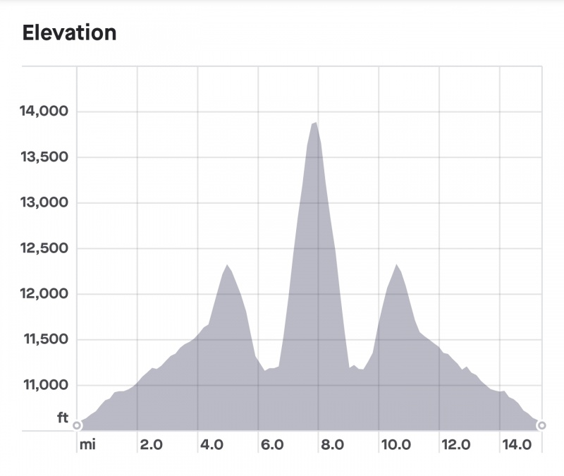
The weather was great though, the thermometer read in the 50s below treeline, and I was down to a t-shirt and still sweating too much! Luckily, the warm temps and sunshine firmed up our bottomless trenching heading back to the pass, and we all agreed it was almost easier going back up! We took our time and enjoyed the cruiser walk out on the road, and the bright moon kept headlamps in the bag. This was a “You gotta go to know” kind of day. We had planned a longer more difficult route to avoid any avalanche terrain, but the unexpected gift of significant melt as well as onsite evaluation put us on a much shorter course that we were happy to take. One of those rare “Type 1 Fun” Winter 14er days. 
Approximate Stats: 13.5h car to car 15.5mi 6300 vertical gained Approximate Times: Start: 4:30AM Summit: 12:15PM Car: 6:00PM 
Thumbnails for uploaded photos (click to open slideshow): ")
")
")
")
")
")
")
")
")
")
")
")
")
")
")
")
")
")
")
")
")
")
|
| Comments or Questions | ||||||
|---|---|---|---|---|---|---|
|
Caution: The information contained in this report may not be accurate and should not be the only resource used in preparation for your climb. Failure to have the necessary experience, physical conditioning, supplies or equipment can result in injury or death. 14ers.com and the author(s) of this report provide no warranties, either express or implied, that the information provided is accurate or reliable. By using the information provided, you agree to indemnify and hold harmless 14ers.com and the report author(s) with respect to any claims and demands against them, including any attorney fees and expenses. Please read the 14ers.com Safety and Disclaimer pages for more information.
Please respect private property: 14ers.com supports the rights of private landowners to determine how and by whom their land will be used. In Colorado, it is your responsibility to determine if land is private and to obtain the appropriate permission before entering the property.


