Download Agreement, Release, and Acknowledgement of Risk:
You (the person requesting this file download) fully understand mountain climbing ("Activity") involves risks and dangers of serious bodily injury, including permanent disability, paralysis, and death ("Risks") and you fully accept and assume all such risks and all responsibility for losses, costs, and damages you incur as a result of your participation in this Activity.
You acknowledge that information in the file you have chosen to download may not be accurate and may contain errors. You agree to assume all risks when using this information and agree to release and discharge 14ers.com, 14ers Inc. and the author(s) of such information (collectively, the "Released Parties").
You hereby discharge the Released Parties from all damages, actions, claims and liabilities of any nature, specifically including, but not limited to, damages, actions, claims and liabilities arising from or related to the negligence of the Released Parties. You further agree to indemnify, hold harmless and defend 14ers.com, 14ers Inc. and each of the other Released Parties from and against any loss, damage, liability and expense, including costs and attorney fees, incurred by 14ers.com, 14ers Inc. or any of the other Released Parties as a result of you using information provided on the 14ers.com or 14ers Inc. websites.
You have read this agreement, fully understand its terms and intend it to be a complete and unconditional release of all liability to the greatest extent allowed by law and agree that if any portion of this agreement is held to be invalid the balance, notwithstanding, shall continue in full force and effect.
By clicking "OK" you agree to these terms. If you DO NOT agree, click "Cancel"...
Go Big, and then Go Home Peak(s): El Diente Peak - 14,159 feet Mt. Wilson - 14,246 feet "West Wilson" - 14,100 feet Posted By: blazintoes Post Date: 02/21/2016 Date Climbed: 02/21/2016
Have you ever seen the San Juan's in winter? Until Saturday, neither had I and whoa they look like a pack of hibernating Jabberwocky's veiled under their winter coat, only these mountains are no fictional character, "beware jaws that bite and claws that catch!" So here I go a little Amy in wonderland galumphing my way to the Rock of Ages trail head with a big agenda. Often, I bite off more than I can chew and most of my plans require great optimism but honestly I was very worried about this plan. Day trip the El Diente to Mount Wilson traverse solo in winter. The weather was predicted perfect and none of my 3 desired partners were available. I received one piece of advice from Tony that perfectly cleared my doubtful mind, "...you've been well trained so don't focus on success or failure, just focus on the next step." Good girl, now go!
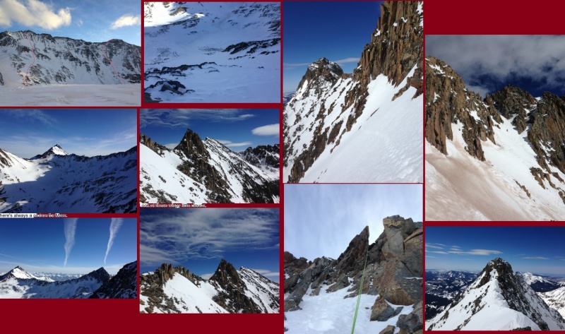
Collage
CR 622 is plowed to within 4 miles of the Rock of Ages (ROA) summer trail head and when I arrived on Saturday early afternoon my friend Abe told me he had a couple buddies (DannyG) attempting Wilson Peak that day. Around 3:45 pm I hear a familiar crunch, crunch, crunch noise and sprung up from my princess pad to see someone carrying skis. "How was Wilson?" I ask. He said the snow was horrible with lots of post holing, they triggered an avalanche and never made it to the ROA saddle but since I would be on snowshoes I should be fine. My stomach churned. After some light banter and jokes about why winter mountaineering because really it is quite silly, they left and I pulled out the maps to notice the road forks about 2 miles up. I almost scampered away and chickened out but after a careful study of the maps, decided I would make a left turn instead and steer clear of the avalanche potential.
By 1am Sunday I was rested, geared up and ready to hit the road. Instantly I could feel the drag in my legs, "oh, c'mon," I plead and despise when my legs are heavy. Did I not fully recover from last week's death march? Sometimes my ego writes checks my body can't cash, but I'll Top Gun it anyhow, right Tony? At 1.8 miles I'm at the CR 622 junction and the Wilson Mesa trail head that says all modes of transportation are welcome, bikes even. How I love friendly trails. I veer left and follow an established ski track another 2 miles then navigate up and over a small avalanche and soon am at the Silver Pick Mill. I've been to this area once in summer but with daylight; it's the day I met my favorite peak bagging buddy Joe from Chicago. Above tree line now, the moon is obnoxious and some confused animal is barking at me. It's the strangest bark I've ever heard. I imagine it's a baby bear knowing they don't bark but it's the scariest thing I can think of and surly they must think spring is around the corner and I smell like a blueberry fig bar. Or, it's a coyote pup that can smell my blood because I have an out of control bloody nose. The cold dry air popped a small blood vessel and what I thought was a runny nose is now deep red all over my gloves, pants and snowshoes, ewe. I clean myself up and think I'm real smart navigating to the summer trail now with the ROA saddle just 1000 feet up and away. Up, up, up I go and slowly realize, holy crap I'm in an avalanche trap and in a big bad way. A little cat in a tree and I feel trapped, "idiot" I scream at myself. Even if I had 10 moons shining brightly at me I would have made the same mistake. Navigating solo in the dark on steep snow is scary. Only 200 feet to go and I spy a rock rib and clumsily snowshoe my way up, then track left, another small rock rib then finally can see the remaining summer trail to the saddle. Little did I know, that would be the worst part of the day.
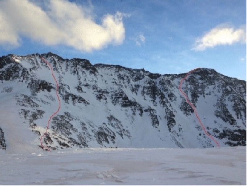
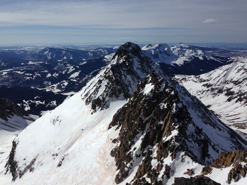
Four hours now and I'm at the 13,000' ROA saddle waiting for daybreak so I can study El Diente's north face. Tony tells me that Eskimo's have over a hundred words for snow because of the many various shapes it forms. At the ROA saddle I now have to lose 1000' on a south facing slope into the Navajo Basin and I know the Swiss term for this kind of snow, 'névé' and is how these periglacial areas form. Not wanting to downhill snowshoe I thought of my husband Marc who occasionally I get to torture on hikes and he goes downhill backwards to save the ol' knees. So I do an about-face and dig my snowshoe claws into the crusty ice and whaddya know, Marc is a genius. My knees thank him. The sun is perking up now, I stash my snowshoes at the last cairn on Mt. Wilson's north slopes route, mark the spot on my GPS and delicately walk a half-mile to the base of El Diente.
El Diente north face up and Wilson down. Routes.
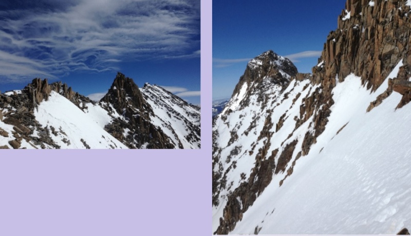
The aesthetic beauty of a mountain is important to me as I enjoy studying the anatomy so I'm able to select the desired line. "I see you," I say as I greet my next challenge. El Diente's north face has one distinct fat couloir but my 3-D mind spots another line to the right. "Don't be scared" I tell myself. Often staring at something long enough breeds doubt but as I'm deep in the belly, the story unfolds. Red lines delineate my routes here (afternoon picture that turned out better) The iPhone, not so good at low light imaging. Good morning El Diente and Mt. Wilson.
The sun is just perking up now between Gladstone and Mt. Wilson I pull out my beloved tools for this moderate class 3 snow climb and give my Venom axes a kiss, muah! There is no greater joy to me than to powerfully pounce my metal blades into unforgiving snow, well maybe sitting on the couch eating a bowl of my yummy homemade popcorn watching a movie with Marc might be better, mmm hmmm. Abe is in my head now and I hear him telling me to pace myself, count 20 steps and take a break. My slow pace, balanced breath and the calm quiet air are nearing perfection.
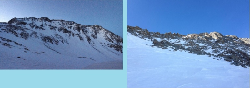
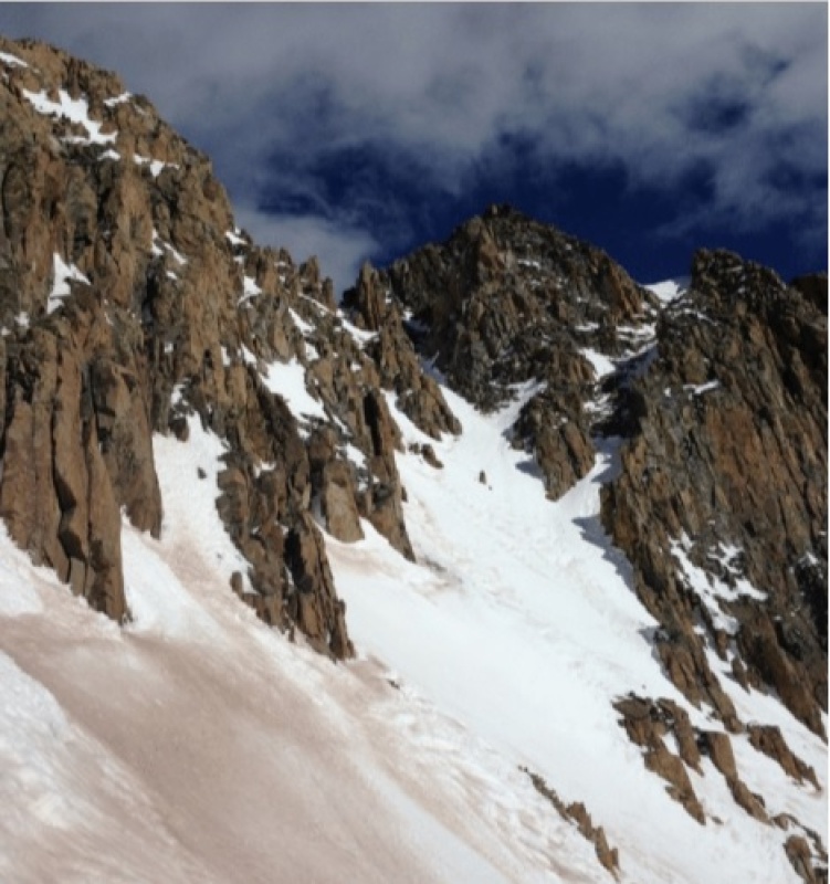
El Diente north buttress
Half-way up I see foot tracks in the couloir to my left and is the first time I've seen any tracks since the first small avalanche I navigated way down low on CR 622. The snow is damn good on this side and has a stable spring quality. I slowly thread my way to the base of the first set of small towers and arrive at the distinct notch ready for the next step, which is a delightful scramble to the top.
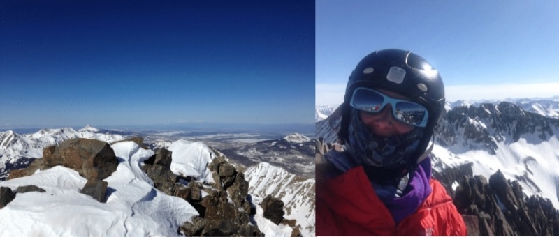
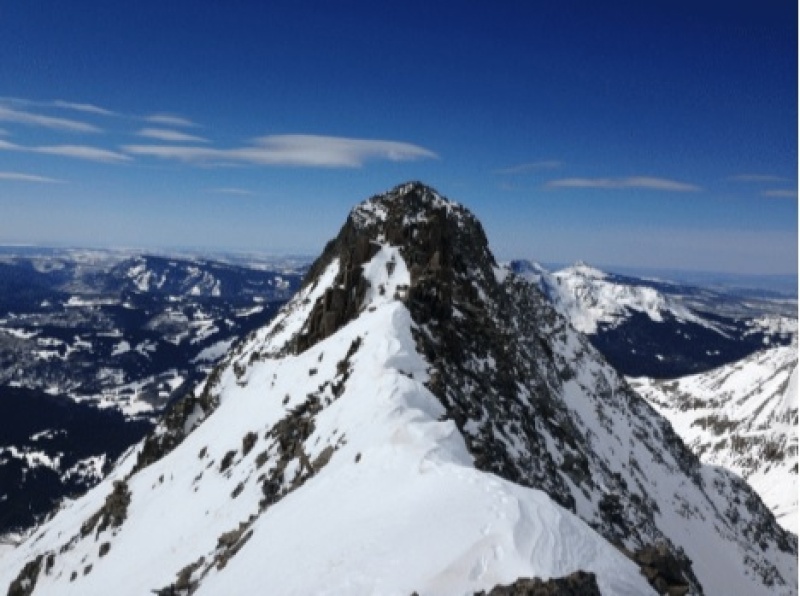
Just after 10 am and the summit is mine all mine. Everyone should see from the top of El Diente on a calm winter day.
I can see into and past Utah from here, wow! Slowly I turn to see what's behind me and my eyes are violated by all the beauty. Hello San Juan beauties, there are like 400 spiky peaks staring at me. There is one obvious nasty little ridge really staring at me now and I predict a 4 hour ordeal. Time for a reality check, how do I feel, how's my time and what is the next step? All signs point towards, give it a go. Back to the notch and then a small drop to the south side towards the organ pipes. At this point looking at the sinuous traverse I thought it would be smart to drop even further in an attempt to avoid the tedious scrambling on rocks in crampons and like a duck on ice, the snow was treacherous. Don't do this, ever, just stay high below the ridge crest. After I burned another match and found my way back on route I was able to work up over and around the gendarmes then had a 200 foot snow climb the ridge top. Wispy clouds are my constant companion along the gendarme puzzle traverse where I had a hack of a time schwacking at the ice. Half-way on the traverse I see West Wilson and dance on up virgin snow. Easy cruising now, I'm taking my time and more pictures. When the day is nice, pictures are easy.
A look back at El Diente and what would the ink block test reveal if I said I see an angry owl giving me the bird, twice.
On West Wilson now and have two options, stay on the rocky top or drop to the sun baked snow. Both have their advantages, regardless I have to descend here so might as well check the snow conditions before committing. Sometimes dirty snow is stable snow. I drop in and am fortunate the snow is once again stable so I continue my traverse to Mt. Wilson's southwest facing 'Y' shaped gully. I like the diamond summit shape it carved. Here some ice on top of weak snow that I punched through, hip deep.
Traverse
Once in the gully I angle left then up to the Mt. Wilson notch that leads to the final crux. Dog tired now but perk up when I see fun rock climbing ahead. The west side is very exposed, the east is a little icy. I begin on the west but feel uncomfortable and my instinct says to back off so I wrap around to the east. Even though it's icy I find excellent ice ax and crampon placements taking careful note of the moves since I might choose to reverse them. With a relentless tenacious appetite to get to the top I didn't take pictures of the final summit crux, just from the top. Sooooo pretty...
Traverse
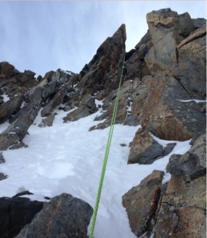
Finally I'm standing on top of Mt. Wilson looking back at what I just accomplished, no friggin' way, yay! I drop my pack, send Marc a spot and do some push-ups, jump up and down and do a little dance. What a day! A little break and a little snack and because of the ice below, decide to bust out my rope. I found a perfect anchor on a solid rock, cleaned up the loose janky rock around it and made a sling to wrap around the rock. Then girth hitched my Purcell prusik to my belay loop and binered it to my ax. I found a solid anchor point for the ax then body weight checked my rope and trusted it with my life so grabbed my ax and slung it in my hip holder then rappelled down well short of the saddle but knew this would happen with a 30 meter rope. I repeated all the above steps but this time used a Mr. Goldstein trick of natural protection and slung a rock, sans sling. He'd be so proud. It's quick and it works.
Rope tricks
At the final 14,100' northeast facing gully, which I remember well from three summers ago but now with snow is much more inviting. With fancy feet and my sweet baby axes I front pointed, side hilled and even glissaded down to an upper shelf then faced in and rock climbed down the lower shelf. The snow here was perfect for glissading and I even felt comfortable practicing three controlled self-arrests, which I think is always a good idea. I spy my snowshoe cache and quickly get to it then take a long look back at my work. Time for a well-deserved break here in the basin where I melt some snow, refill my water bladder, sip on some tea then bouillon, how I love salty snacks especially when parched. After an hour or so it's about 5pm and still some daylight and now after the break and the whirlwind of excitement my legs feel pretty good, should I go for Wilson Peak? Once at the ROA saddle I'd only have 1200' or so to go and I know a secret way to the top of the ridge that would bypass the loaded south face. Or, do I savor the available daylight and navigate down the treacherous avalanche trap below the ROA saddle? Again my instincts were screaming at me, no need to be greedy, just do the right thing and get down and out ASAP but like the terminator, I'll be back... unless the popcorn and movie thing convinces me otherwise.
You stay classy San Juan's
I motored up the saddle and was pleasantly surprised the snow here in the basin maintained its névé quality, not good for skiing but great for snowshoes and once at the top my mistakes all told their tale, ah ha! If I were to get a re-do, once at the Silver Pick Mill I would take an immediate left turn and slither my way up the snow tongue that would lead straight to the ROA saddle. But now I know what do to if I ever get back here. I taught myself a new trick and with my MSR lightning snowshoes front pointed all the way down to the bottom. Dad Mike recommended them and I just love the aggressive teeth and light weight feel. No need to get all excited now because I still have a long 5 miles back to Roobie. The moon has made a near full rotation and greets me from the east. The barking morning critter is asleep and I find my old tracks and curse my tired feet. Nothing exciting happened except one little spill and a twist of my bad ankle and I think, what a way to beat a dog when it's down but a small price to pay for such success. The last ½ mile is riddled with boot deep post holes but at last, 17.2 miles and 20 hours later there she is, my sweet Roobie with treats, water and a nice soon to be warm princess pad. I text Marc, Tony, Abe and Mr. G of the days success, eat a delectable homemade quinoa burger and fall into a deep peaceful sleep.
I'm kind of a big deal. People know me.
My GPS Tracks on Google Maps (made from a .GPX file upload):
Thumbnails for uploaded photos (click to open slideshow):
Comments or Questions
Caution: The information contained in this report may not be accurate and should not be the only resource used in preparation for your climb. Failure to have the necessary experience, physical conditioning, supplies or equipment can result in injury or death. 14ers.com and the author(s) of this report provide no warranties, either express or implied, that the information provided is accurate or reliable. By using the information provided, you agree to indemnify and hold harmless 14ers.com and the report author(s) with respect to any claims and demands against them, including any attorney fees and expenses. Please read the 14ers.com Safety and Disclaimer pages for more information.
Please respect private property: 14ers.com supports the rights of private landowners to determine how and by whom their land will be used. In Colorado, it is your responsibility to determine if land is private and to obtain the appropriate permission before entering the property.

")
")
")
")
")
")
")
")
")
")

