Download Agreement, Release, and Acknowledgement of Risk:
You (the person requesting this file download) fully understand mountain climbing ("Activity") involves risks and dangers of serious bodily injury, including permanent disability, paralysis, and death ("Risks") and you fully accept and assume all such risks and all responsibility for losses, costs, and damages you incur as a result of your participation in this Activity.
You acknowledge that information in the file you have chosen to download may not be accurate and may contain errors. You agree to assume all risks when using this information and agree to release and discharge 14ers.com, 14ers Inc. and the author(s) of such information (collectively, the "Released Parties").
You hereby discharge the Released Parties from all damages, actions, claims and liabilities of any nature, specifically including, but not limited to, damages, actions, claims and liabilities arising from or related to the negligence of the Released Parties. You further agree to indemnify, hold harmless and defend 14ers.com, 14ers Inc. and each of the other Released Parties from and against any loss, damage, liability and expense, including costs and attorney fees, incurred by 14ers.com, 14ers Inc. or any of the other Released Parties as a result of you using information provided on the 14ers.com or 14ers Inc. websites.
You have read this agreement, fully understand its terms and intend it to be a complete and unconditional release of all liability to the greatest extent allowed by law and agree that if any portion of this agreement is held to be invalid the balance, notwithstanding, shall continue in full force and effect.
By clicking "OK" you agree to these terms. If you DO NOT agree, click "Cancel"...
Somehow managed to make a hellish struggle out of this famously easy and beautiful peak.
I saw the Blaine Basin route in Roach's book, and decided to make a loop: Blue Lakes -> SW Ridge -> SW Slopes -> Blaine Basin. I did this because I prefer to see different scenery along a loop, all else being equal. Along the drive, I also listened to nonstandard14er podcast's episode on Sneffels. The episode mentioned this route as an "ultramarathon loop", although it's actually shorter than the common Blue Lakes out-and-back.
One hypothesis for the origin of Sneffels name is from the novel, Journey to the Center of the Earth. This hike certainly felt like descending to hell, getting worse throughout the day.
9 circles of snell
First circle of Snell
Between 9pm and 4am, the forecast changed from "no rain before noon" to "30% chance of rain AM". Fuck.
Second circle of Snell
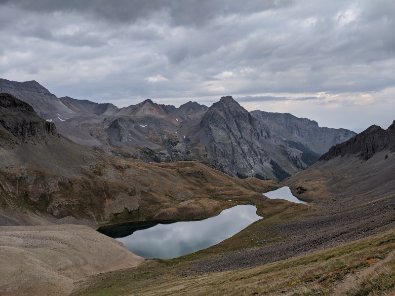
Beautiful blue lakes views during brief decent weather from 5am to 8am
Looking down on lower blue lake. This report doesn't knock Blue Lakes approach. go for it! Just don't descend Blaine Basin.
Third circle of Snell
Rain starts at the upper blue lake (12k) at 8am. Fuck. Rush up the trail to Blue Lakes Pass (13k). Note: I had been worried that this trail would be just an unofficial scree-scramble, but mercifully it was actually a high-quality and not-too-steep set of switchbacks.
Looking down on upper and middle blue lake from the good trail up to Blue Lakes Pass.
Fourth circle of Snell
First section of SW ridge scramble is extremely slippery. This easy c3 on wet rock is scarier than bells traverse. In hindsight should have lost some elevation and taken standard.
Fifth circle of Snell
Reprieve as the rain let up, and the remaining scramble was on concrete-like rock that's ok when wet. Never did find the V notch. Possibly bypassed it with some slippery spicy moves. Summit views not so great because of the clouds.
Sixth circle of Snell
Start out standard route descent, aiming for the saddle between Sneffels and Blaine Basin. Descended the wrong gully as usual. Naked couple helped me get back on track.
Seventh circle of Snell
At the top of the descent to Blaine Basin, some scree-skiing is possible. At that point, I planned to recommend Blaine Basin to anyone who enjoys scree-skiing, and anti-recommend it to those who want every step to be in control.
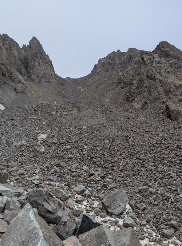
Looking down toward the Blaine Basin descent. It looks so threatening, i should've known what I was getting myself into.
Eighth circle of Snell
But, the scree soon became too big to ski. And it's never-ending. Continually think I'm on the verge of reaching easy tundra but there's always more terrible sisyphean scree. I spied the Blaine Basin trail after a couple hours, but it took a long time to finally reach it. This descent is absurdly terrible.
Cardio is my achilles' heel. A class 4 downclimb is easier for me than a class 1 steep upclimb. Therefore, I never met a descent I didn't like. Until this day. This is the most difficult, strenuous, miserable descent I've ever done.
Blaine Basin is beautiful in a Mordor kind of way. But it doesn't come close to justifying the misery needed to reach it. And Blue Lakes is of course gorgeous. If you came from Blue Lakes, you should always return that way rather than Blaine Basin. Now, I understand you may not want to downclimb SW ridge if it's wet or if you're just getting started on C3. And standard would require re-climbing to Blue Lakes pass. But, I guarantee that taking standard down, then reclimbing to Blue Lakes pass, will be less effort and more pleasant than Blaine Basin.
Looking back up toward the Blaine-Sneffels saddle. At this point, i thought I had almost reached easy tundra. But I was only about half done.
Ninth circle of Snell Lost my water bottle, out of iodine pills, streams are too mosquitoey to drink untreated. Dehydrated. Rain starts up again HARD with 2 miles left.
The weather on 8/29 promised to be even worse. So I canceled the 4th day of my San Juans trip, which would've been Ice Lakes 13ers. Since Sneffels is usually so beautiful and easy, I hope to quickly redo Sneffels via Yankee Boy when I return to the San Juans next year.
My GPS Tracks on Google Maps (made from a .GPX file upload):
Congratulations on a beautiful mountain and a really fun way to ascend Sneffels. Of course, it was dry when I went up that way many years ago.
You certainly have been climbing a lot of mountains this summer.
Caution: The information contained in this report may not be accurate and should not be the only resource used in preparation for your climb. Failure to have the necessary experience, physical conditioning, supplies or equipment can result in injury or death. 14ers.com and the author(s) of this report provide no warranties, either express or implied, that the information provided is accurate or reliable. By using the information provided, you agree to indemnify and hold harmless 14ers.com and the report author(s) with respect to any claims and demands against them, including any attorney fees and expenses. Please read the 14ers.com Safety and Disclaimer pages for more information.
Please respect private property: 14ers.com supports the rights of private landowners to determine how and by whom their land will be used. In Colorado, it is your responsibility to determine if land is private and to obtain the appropriate permission before entering the property.


")
")
")
")