Download Agreement, Release, and Acknowledgement of Risk:
You (the person requesting this file download) fully understand mountain climbing ("Activity") involves risks and dangers of serious bodily injury, including permanent disability, paralysis, and death ("Risks") and you fully accept and assume all such risks and all responsibility for losses, costs, and damages you incur as a result of your participation in this Activity.
You acknowledge that information in the file you have chosen to download may not be accurate and may contain errors. You agree to assume all risks when using this information and agree to release and discharge 14ers.com, 14ers Inc. and the author(s) of such information (collectively, the "Released Parties").
You hereby discharge the Released Parties from all damages, actions, claims and liabilities of any nature, specifically including, but not limited to, damages, actions, claims and liabilities arising from or related to the negligence of the Released Parties. You further agree to indemnify, hold harmless and defend 14ers.com, 14ers Inc. and each of the other Released Parties from and against any loss, damage, liability and expense, including costs and attorney fees, incurred by 14ers.com, 14ers Inc. or any of the other Released Parties as a result of you using information provided on the 14ers.com or 14ers Inc. websites.
You have read this agreement, fully understand its terms and intend it to be a complete and unconditional release of all liability to the greatest extent allowed by law and agree that if any portion of this agreement is held to be invalid the balance, notwithstanding, shall continue in full force and effect.
By clicking "OK" you agree to these terms. If you DO NOT agree, click "Cancel"...
An Unexpected Challenge Driving The Lake Como Road
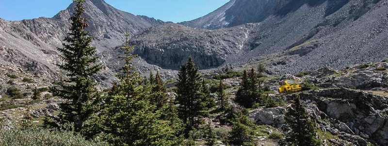
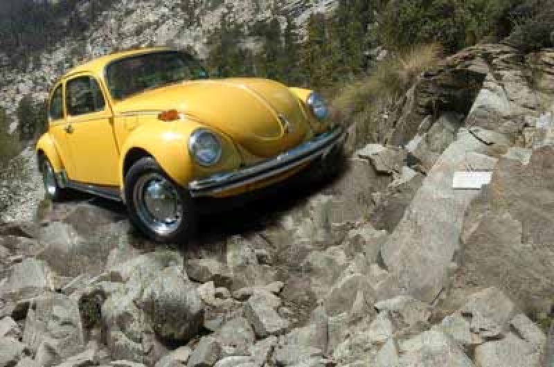
Useless vehicle almost at the lake
I must admit I only partially read the trailhead description for the lake como road, but it was hands down the worst “road” I’ve ever driven. To say the least, this road was not paved, and to say the most, this road was absolute trash. In my defense this website advertised it as a road, so I just assumed it was paved. It took me the better part of a day to drive it to the top, causing me all sorts of problems and essentially destroyed my girlfriend’s (now ex) car. So to anyone who brings a non-4WD car, expect at least 2-3 full days to make it to the top of the road and back down.
Being somewhat of an elite hiker myself I was looking for a real challenge this weekend. I considered the Bross-S.Bross traverse but figured it might be too risky, especially with high winds in the forecast in the notorious Mosquito Range. Would make the exposed ridge difficult to navigate! After further research it was concluded that the Lake Como road and 14ers Ellingwood Point , Mt. Blanca , and easy 13er Little Bear Peak might fit the bill. If time allowed it, I wanted to hike all 3.
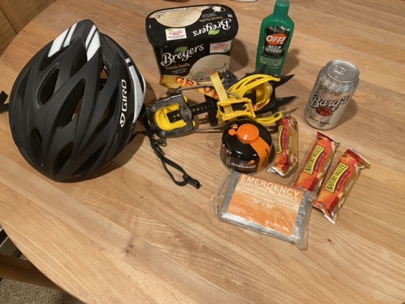
Per usual, I elected to pack light but still carry all the essentials with me. I've gotten a lot of questions lately what I usually bring so I have attached a pic below. This honestly is all I usually bring and it it hasn't failed me yet. I then headed out in my girlfriend’s (now ex) VW Bug at around 5am from Greenwood Village. I would have brought my own modified Jeep but it was out of gas. In hindsight I now realize I should have brought the Jeep and just filled up at a gas station on the way down.
The 10 essentialsDriving to pick up Bryan
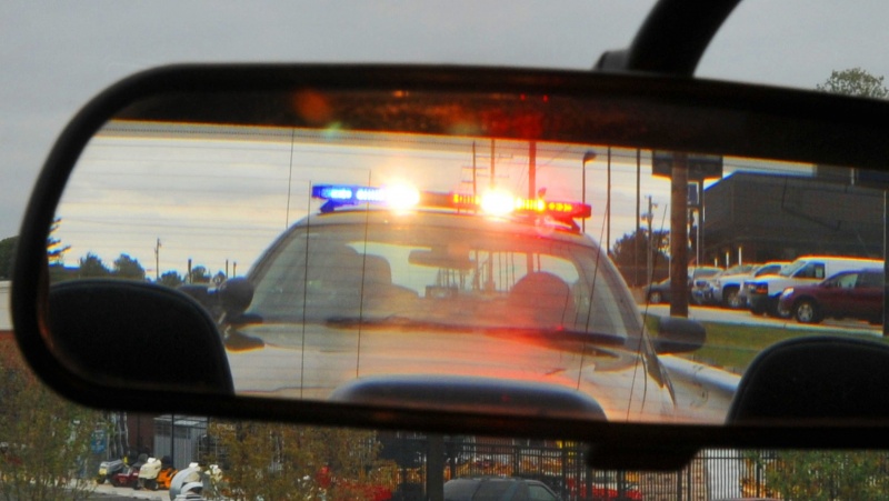
The way down was uneventful. I picked up my flatlander buddy Bryan (bludwig) who was visiting CO from Kansas. He told me he used to do some bouldering at the gym so I figured he probably would be ready for this trip. In addition he told me that he scaled the tallest peak in Kansas so that had to count for something. This would be his first 14er trip, so he was understandably exited. After grabbing iced coffees from Starbucks we made our way south. It took quite a while to actually get down to Como Road because the VW Bug was slow af. Unfortunately I did get a speeding ticket on the way down for going too fast in a construction zone. The officer gave me the choice of a lecture or a ticket. Already running short on time, I opted for the ticket.
I opted for the ticket
We eventually got to the base of Como Rd at 11:34am, about 6.5 hours after Ieaving Greenwood Village. At this point I was pretty upset because I knew we had to really hustle if we were going to complete the grand 14er traverse between Blanca and Ellington before dark. To make matters worse, the Como Rd was in absolute garbage condition. My girlfriend’s VW Bug basically struggled from the moment the road started. After 10 or so seconds of driving up the road I abandoned my hope for the traverse. I thought if we could drive to the lake at a reasonable hour we could at least hike the less rigorous 13er, Little Bear, as a consolation.
Slowly but surely we started to weave up the lake Como road. I was probably going no more than 2-3 mph. Several hikers passed me on the way up. In this beginning segment, we commonly had to stop to push rocks out of the way or else they’d cause the car to get stuck. The base of this car is unusually low. In all honesty this vehicle is not practical for this type of activity. There was a jeep in front of us but they didn't know what they were doing which slowed us down even more.
Inexperienced no0b drivers in front of us
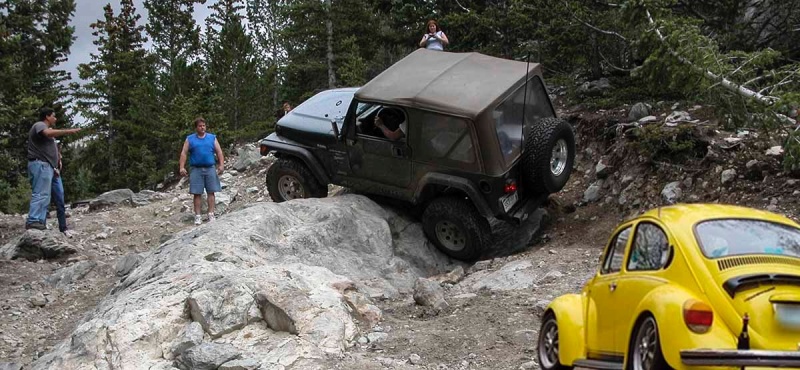
After about 3 or miles of grueling torture we finally made it to where the National Forest began. I figured this area might be better maintained but I was definitely wrong. If anything, the road actually got worse. We were able to eventually able to drive to this mega obstacle of slanted and pointed rock. I must admit this part made me consider turning around, but after some internal deliberation I decided to floor it and hope for the best. The first attempt went horribly, and the underside of the VW scraped hard against the rocks, making the worst noise I’ve ever heard a car make. The car rolled backwards, back to the original position. Honestly I was relieved it didn’t flip because I would not have wanted to explain that to my girlfriend (now ex). Little did I know then, I would have worse explaining to do later.
One of the harder obstacles
Despite this failure, second time did the trick, as I applied even more speed than the previous time. I still scraped the entire underside of the car against the rock, but the combination of rapid acceleration, momentum, and torque did the trick.
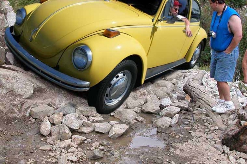
After navigating a couple switchbacks, we came up again to another obstacle similar to the previous one. Using the same technique as before, we made quick work of it, except the rocks on this one broke something pretty bad on the car’s underside, causing gas to leak everywhere. At this point I quickly realized we’d have to pick up the pace if we were to make it to the top of the road before running out of gas.
Car scraped big time here
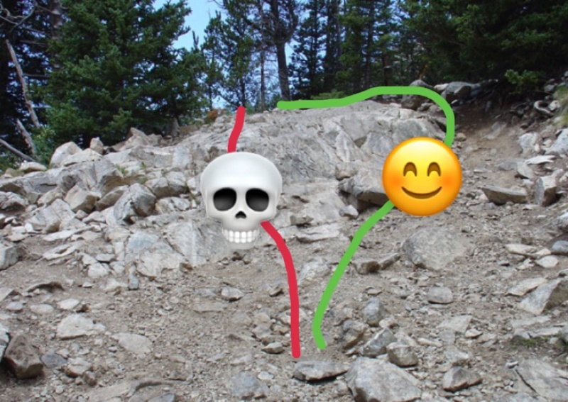
I’d say that move was probably the crux of this route. I’ve included a picture with route recommendations. The red route is exposed and dangerous and I would not recommend it, while the green has better rock quality and is an overall safer option. If you find yourself driving anything that exceeds 6 bars of TH difficulty, it probably means you are off route. I found a helmet reassuring to wear during this section.
General idea of the crux
Eventually after a stint of driving through the trees, we stumbled upon another obstacle. At this point the obstacles were really starting to get annoying. This one had a V notched shaped massive indent. There was just no way the car could make it over without outside assistance. Fortunately, we flagged down some hikers, and after several efforts were able to force push the car up this obstacle with only moderate damage to the vehicle.
Almost to the lake!
After driving through a boulder field, we FINALLY made it to the lake. And just in time too, because the car was overheated and subsequently died within minutes of arriving to the top. Also, basically all the gas leaked out anyway. We tried to restart the car several times to no avail. Nobody else had their car up there so we couldn’t even try jumper cables. Knowing my girlfriend (now ex) needed her car to drive to work tomorrow, I called AAA to see if they could send a worker up here but they said it wouldn’t be possible. I tried every option to convince them to come up but they eventually politely yet firmly hung up.
At this point it was pretty late in the afternoon , and I definitely knew I wouldn’t even be able to hike the traverse or do Little Bear. At the same time I knew I was gunna be screwed for ruining my girlfriend’s (now ex) car. Since AAA wasn’t going to come up anyway we decided to put the car out of its misery. I rounded up a couple of hikers and after some disagreement we decided to push the car into the lake where it probably won’t ever be seen again. That way we didn’t have to deal with somehow getting it back down to the bottom. In addition, it would satisfy LNT guidelines since nobody would ever notice a car at the bottom of a lake.
Walking down the entire road that night was probably worse than driving up it. It took forever, and I would not wish this hike on even my worst enemy. I was basically starving and at this point wishing I’d never even come here.
Overall, the trip didn’t go as planned and the fallout was fairly dramatic. My girlfriend dumped me for the incident, but more importantly I still didn’t get to hike any of these mountains, all because of this stupid road. At least my mom was happy I made it down safe.
Good riddance
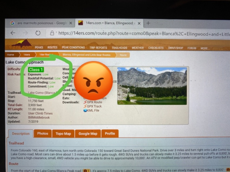
Details matter, this should never have been called a road and I advise that this website’s owner adjust the the description accordingly. If not, many more will make the same mistakes as I did and have no choice but to abandon their vehicles at or in the lake. For example, this website lists the commitment as “low”. Obviously that is not the case.
misleading information
Final Trip details below (No go pro footage because I left that in the glove compartment and sadly forgot it before we pushed the car into the lake) :
Start from Greenwood Village: 5.02 am
Arrive at Starbucks: 5.23 am
Base of lake como : 11.34am
To the lake: 7.10pm
Mileage: 7.4 miles (to the lake)
Minimum Speed: 0 mph (stop light near my house)
Max speed: 68 mph (construction zone area)
Thumbnails for uploaded photos (click to open slideshow):
Recommendation for overcoming one of the obstacles by noting red (X) and green lines are the touches I find helpful in any TR. ... I almost died when I saw your annotation of the route description page.
One semi-auto crampon and fuel canister (without burner) is how we should all pack in the summer. But not bringing TP and tourniquet is pushing the envelope, rad bro!
What tires and pressure would you recommend on the 'Wagen for adventure such as this?
If I had known that the "Bug" could make the road to the lake I could have saved myself a lot of hiking (twice or thrice) while enjoying the radio, ac and being cool all at the same time. The people I work for have a yellow "Bug" so I may just borrow it, probably don't need to ask permission...it just sits in the garage :)
It's been a while since I've been inside a VW Bug but the interior looks surprisingly like the inside of my 4Runner! Also - how did your hair get longer after you picked up your buddy?! Now its time... for the real story! I can't wait!
Also - I almost spit my coffee out drinking this... so freaking funny! I'm only hoping the follow up will match the original.
What an absolute waste of time reading this. Such a disservice to this community. Obviously your trip report is BS coupled with your sophmoric photoshopped images trying to prove a point that the route description and road access isn't clear or it's misleading!? Even after admitting "I must admit I only partially read the trailhead description for the lake como road". The worst part of your dumb ass story is that other members believe it to be true or thought it to be "funny" and have liked your trip report. "Recommendation for overcoming one of the obstacles by noting red (X) and green lines are the touches I find helpful in any TR." Really!? Does anbody moderate this site!?
The description of the road is well documented along with pictures! You just needed to scroll down a little more and actually read them! Details do matter, you just chose to disregard them. I am going to advise the website's owner to remove your account for posting such B.S. I hope your trip was 100 time worse than your lame childish make beleive trip report! People like you should not be out in areas like this, you're going to hurt yourself or more importantly someone else! Just stay home and stay connected.
This is hilarious nice work! Hope your next girlfriend has a 2wd sedan, and you can pick me up so I don't have to hike up the road, then we can push it into the lake to give the VW some company.
You had me going for a min, but you seeing how you managed to change your rims to hubcaps in pic #4 to pic#1, not to mention forgetting to Photoshop back in your driverside mirror....
In all honesty you should take this down before someone new here quickly innocently browses this TR and then tries to repeat it at 2am with their 2wd rental sedan thinking a Bug can do it and
then kills themselves flipping over.
This is perhaps the finest Trip Report I have ever read. I'm feeling really optimistic now about getting my 2WD Sedan all the way to the lake. I definitely have more clearance than the VW. Thanks again for the detailed info.
In a world of misinformation and devisivness I came here as I have for years to get reliable and accurate info on access and routes and then come across this BS TR and call it out as such and get called a party pooper and still have users claiming this is a "nice report"!? Sure it's funny but this is not the place and there are people in this world more ignorant than the author that might not have the ablility to decipher that this is BS as nyker has discussed. Summiting these peaks is inherently dangerous, many people have been injured or have died summiting these peaks. Condoning this "hilarious" trip report is just as bad as the report itself. YOU ARE DOING THIS COMMUNITY A DISSERVICE AND POSSIBLY PUTTING PEOPLE AT RISK! It isn't an argument or discussion, it's just wrong. At least there are still some people who have common sense and see the ramifications of letting this post persist and the possible harm it could cause, thank you nyker. It's unbelievable that I have to justify the fact that this is wrong or that this TR is even still up!
ok I am not a new innocent person so I can give you that, but seriously how could you possibly take this as anything but satire and actually drive a VW up that road, whew makes me worried for a lot people out there
If I were anyone, new or been out there a lot, I would not take just one report as the "be all report" anyway
research and read the 14ers routes and trip reports posted, summit post, loj, etc.
if Bill wants to take this down because it is dangerous or something like that then he should
the author can take it down also to save some people from themselves
take down all the youtube stuff, most advertisements, Facebook, whatever, to to save people from themselves
You underestimate the stupidity of your fellow man and someone possibly not seeing this as satire.
Of course an intelligent/informed person researching a peak would not take this single TR as "be all report" whether they are a newbie or seasoned climber, but again you underestimate the stupidity of your fellow man. Have you happend to see the state of affairs in our society today and the misinformation and the dumb things people do?
My qualm with this TR is that it is wasting people's time (including my time intially when I came across it) who may be doing legitmate research not to mention a disservice to others who browse this site for worthwhile info. In addition the author is using the satirical story to say that the description of the route and the road is misleading, which is not the case by any means. Been using this site for years and the descriptions, info, trip reports and pictures are always spot on, worthwhile and serious, I've always held this site in high regards, legitmate and the best authority on 14ers and 13ers and to see this TR attempt to slander it is unaccepatable to me. And yeah, it could be possibly dangerous for other readers.
Talk about stupid comments "take down all the youtube stuff, most advertisements, Facebook, whatever, to to save people from themselves", how does that at all relate to any of this? Actually that is exaclty where this "hilarious" TR belongs, on Facebook or another social media platform where stupid shit like this is rampant.
At some point you have to realize that there is right and wrong and that this trip report is childish, immature and just plain stupid and just doesn't belong here, it's an island of BS in an otherwise legitmate forum, if you don't see that well then you are part of the problem as well.
Of the problem, I thought it was funny. Made me feel bad for ever doubting the abilities of my hotel ford Fiesta FRD4x4 offroad. Honestly, this site needs a comedic break, and this was perfect. The forum has managed to even get more depressing, boring and repetitive to read than the news. Thank you for having a sense of humor, glad to see someone does.
Funny stuff, but having walked up from the very bottom of the Lake Como road, I know what kind of vehicle it takes to get over those massive granite humps.
Brother pup needs to take a chill pill 8/3/2020 9:50am
Brother pup keeps harping on how reading this funny and creative, obviously satirical post Is such a waste of his precious time. YET, he continues to post comments (3 at last count) on this post, quite lengthy no less, as to how stupid this post is and what a waste of time it is. Brother pup needs to go back to reading trip reports on Bierstadt for valuable information on climbing the 14ers...
Needed some Covid levity and diversion. Well written...loved the photoshopped pics! Laughed so hard while reading this.
Yes people, it's called satiracal writing...and it's enjoyable to read. If anyone reads THIS ONE, single, report on this road and calls their research good...then they will learn, VERY early on, that their hike is going to be much longer than expected.
EVERY other report tells of the awful road. Dubbed, "The most difficult road in Colorado." Only custom 4WD vehicles, with winches and trained spotters attempt this road all the way to the lake.
When I HIKED the road my bottom scraped at least six times, and that was before I put on my La Sportivas for extra traction. With the extra grip, we powered over the notrious Jaws I and Jaws II but my low hanging sleeping pad got SHREDDED. Luckily, someone had abandoned a 1970's-era Fiat at the lake and the back seat is like a mattress compared to a Thermarest. And no need to pitch a tent.
Thanks for the trip report! Really gives me some confidence that I'll be able to take the ol' '83 DeLorean up this thing. I'm also relieved to find out I don't have to walk on this road that from the looks of it, doesn't have a good shoulder to get out of the way of oncoming traffic.
Before reading this, I never had the courage to attempt the drive in my '86 Corolla. I've stocked up on Bryers and Barqs and feel ready to go. You have my sympathy on the girlfriend situation, but honestly, I think she was holding you back. Looking forward to your next report!
I have GreenOnion to thank for pointing me to this epic TR recently. My face hurts from giggling, and my eyebrows hurt from frowning at the epic photoshopping in a "man, I wish I had those skills!" manner of seething jealousy.
Having no critical thinking skills or sense of humor, I used this trip report as the only source of information for my recent attempt to conquer Mt. Little Bear Peak as my first 14teener. On the advice of my lawyer I wont go into detail here about what happened, but I'll see you in court Sbenfield! You ruined my life!!
Caution: The information contained in this report may not be accurate and should not be the only resource used in preparation for your climb. Failure to have the necessary experience, physical conditioning, supplies or equipment can result in injury or death. 14ers.com and the author(s) of this report provide no warranties, either express or implied, that the information provided is accurate or reliable. By using the information provided, you agree to indemnify and hold harmless 14ers.com and the report author(s) with respect to any claims and demands against them, including any attorney fees and expenses. Please read the 14ers.com Safety and Disclaimer pages for more information.
Please respect private property: 14ers.com supports the rights of private landowners to determine how and by whom their land will be used. In Colorado, it is your responsibility to determine if land is private and to obtain the appropriate permission before entering the property.


")
")
")
")
")
")
")
")
")
")
")
")