Download Agreement, Release, and Acknowledgement of Risk:
You (the person requesting this file download) fully understand mountain climbing ("Activity") involves risks and dangers of serious bodily injury, including permanent disability, paralysis, and death ("Risks") and you fully accept and assume all such risks and all responsibility for losses, costs, and damages you incur as a result of your participation in this Activity.
You acknowledge that information in the file you have chosen to download may not be accurate and may contain errors. You agree to assume all risks when using this information and agree to release and discharge 14ers.com, 14ers Inc. and the author(s) of such information (collectively, the "Released Parties").
You hereby discharge the Released Parties from all damages, actions, claims and liabilities of any nature, specifically including, but not limited to, damages, actions, claims and liabilities arising from or related to the negligence of the Released Parties. You further agree to indemnify, hold harmless and defend 14ers.com, 14ers Inc. and each of the other Released Parties from and against any loss, damage, liability and expense, including costs and attorney fees, incurred by 14ers.com, 14ers Inc. or any of the other Released Parties as a result of you using information provided on the 14ers.com or 14ers Inc. websites.
You have read this agreement, fully understand its terms and intend it to be a complete and unconditional release of all liability to the greatest extent allowed by law and agree that if any portion of this agreement is held to be invalid the balance, notwithstanding, shall continue in full force and effect.
By clicking "OK" you agree to these terms. If you DO NOT agree, click "Cancel"...
Although entertaining, you can only learn so much from watching GoPro footage of people panicking on the Knife Edge. Instead, I've found the most value in combing through prior trip reports in preparation for Capitol. With this report, I hope to provide some insight on what a climb of Capitol looks like from the perspective of a normal guy... If you're looking for something unique like a report on the North Buttress, beta on the connecting ridge to Snowmass, or some hero multi-peak linkup, this is not your report. But if you're looking for some info on the standard route along with some pretty photos and my honest take on some of the popular questions about this peak, keep reading...
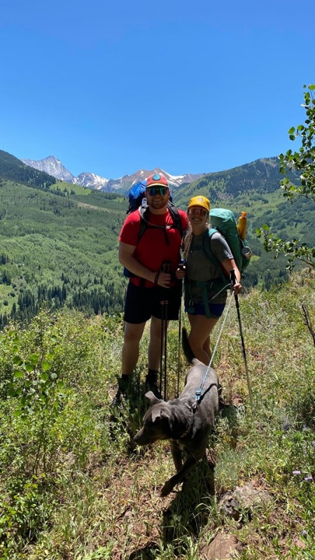
I was planning on saving Capitol for after monsoon season, as I have buddies who've been chased across the knife edge by a lightning storm and their warnings have stuck with me. My buddy Patrick (14er finisher, BCNPatrick) and I were planning on climbing Snowmass on this trip, but with a high pressure system and virtually no chance for rain, we called a last minute audible and decided to go for Capitol. My wife Taylor and our pup Samson were along for the ride, simply to enjoy the hike up and a night camping in one of Colorado's most scenic basins.
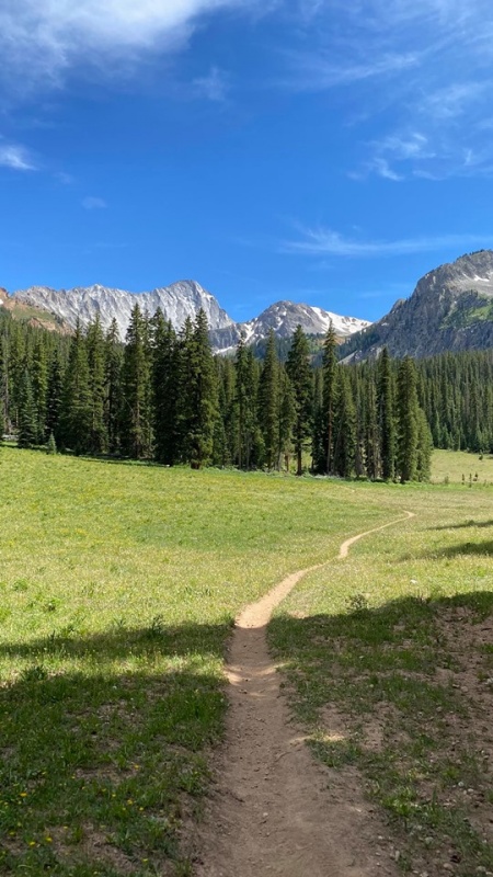
This has to be one of my all-time favorite approaches. It's about 3 hours of meandering through Aspen trees and fields painted with wildflowers, with Capitol in sight the whole way. This mountain seems to stare at you during the entire approach, but in a more welcoming and less menacing way than, say, Little Bear (which always seems to look like Mordor). Taylor described Capitol as "regal" and I couldn't agree more. Part of the welcoming appearance was probably due to the clear skies and 85 degree weather we had the whole way -- spirits were high, as was the temperature.
At the trailheadMany miles of this. No cows for us!
There was a Ranger stopping people to "have a talk" about a half mile before the lake. He was enforcing dog leash laws (which Samson was on the whole time), WAG bags for human waste (which were available for free at the TH), as well as bear canisters. He was extremely strict about the bear canisters and was even turning around groups who didn't have them. Numerous groups were forced to make the 6 mile trek back to the car. To those thinking about bluffing to get by any future "checkpoints" like this... he also visited each camp site around dinner time just to make sure no fibbers got through.
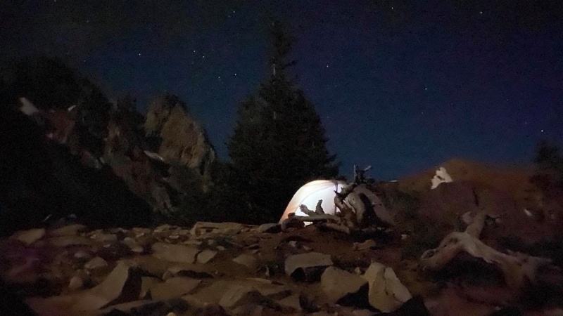
Site #6: best seats in the house... you're welcome. No close water and minimal shade, but the views were insane!Closest water was about 100' vert and .3 mi below our site.
My Garmin showed 2,500' vert and 6.7 miles up to our campsite at about 11,700'. We made the trip in just over 3 hours. The designated camp sites quickly filled up and there were dozens of groups camped on top of each other. It was certainly not the most peaceful night we've ever had in the mountains, but how can you complain with front row seats to a sunset like this?
Goodnight, Capitol.
The forecast looked great, but we wanted to get ahead of the hoards, so we opted for a 3:30 am wake up call. Turns out only a handful of people from the lake were actually climbing Capitol (the rest were just there to party, I guess?), but it was still good to get an early start.
3:30 am wake upSunrise on Mt. Daly, seen from the snowfield leading up to K2
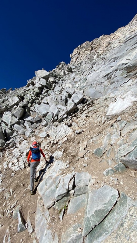
On the trail by 4:15, we made good time out of the gate and were up to the Daly saddle in 35 minutes after leaving camp. We were greeted with an epic sunrise on Mt. Daly as we donned our microspikes and ice axes (if the snow fields look like this, save the weight and leave the crampons at home... microspikes will be just fine).
This section is navigable without traction or an axe, but using both proved to be a lot quicker (used both on the ascent, just axe for balance on the descent).
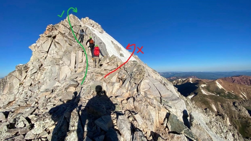
The easier bypass was completely snowed in so we opted to go up and over K2, a more exposed but much more stable route with a couple class 4 moves. It's really a pretty short section... the people ahead give it some scale.
Crossing the snow and talus field below K2 took a bit more time than expected, but just before 7 am we were at K2. As you can see above, the standard bypass around K2 was completely snowed in and it's a long way down if the snow takes you for a ride. I've heard Capitol described as a bowling ball -- flat and round at the top, but it gets progressively steeper out toward the sides, until it drops off to completely vertical. That theory holds true in this photo, where the snow doesn't look too steep, but it's the thousand feet of air underneath (just out of the photo) that's the problem.
I found that to be the case for most of the exposure on this mountain... there were only a couple places where it's completely sheer underneath you; rather, most of it is a steep slope that steepens until it drops off into nothing. Either way, a fall would be fatal, but something about having a bit of dirt and rock underneath me the whole way helped alleviate the exposure heebie-jeebies that I was anticipating.
Top of K2: ready to get to work!If you continue straight off K2, it's extremely high consequence terrain with some difficult moves, so we opted to head down to the right off the K2 summit As the route description says, this is pretty exposed, but the rock is relatively solid here.
From K2 to the summit, it took us 2 hours at a moderate pace with no breaks. I'd recommend having at least a 4 hour weather window for the round trip from K2, as you're 100% committed from this point on.
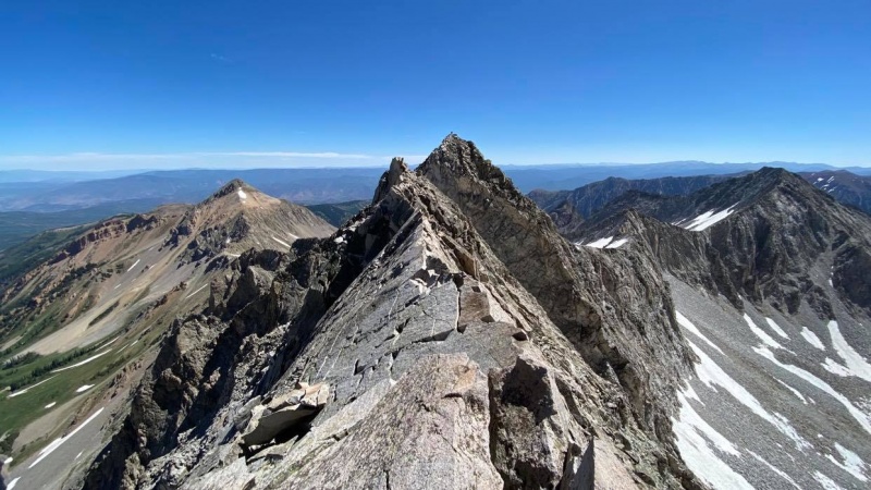
Looking back from partway across the knife edge. Note someone on top of K2 in the background.Looking back at the beginning of the knife edge (about halfway through). This photo gives what I would consider a pretty realistic feel for the knife edge.
As many have said, the knife edge offers the best rock on the whole route. Strangely, this was one of the places where I felt safest, as the rock was completely solid and there was obviously no rockfall hazard from above. I would consider myself relatively exposure-averse at times, and I actually had a blast on this section. I found it easiest to alternate between straddle-scooting and bear crawling across the top.
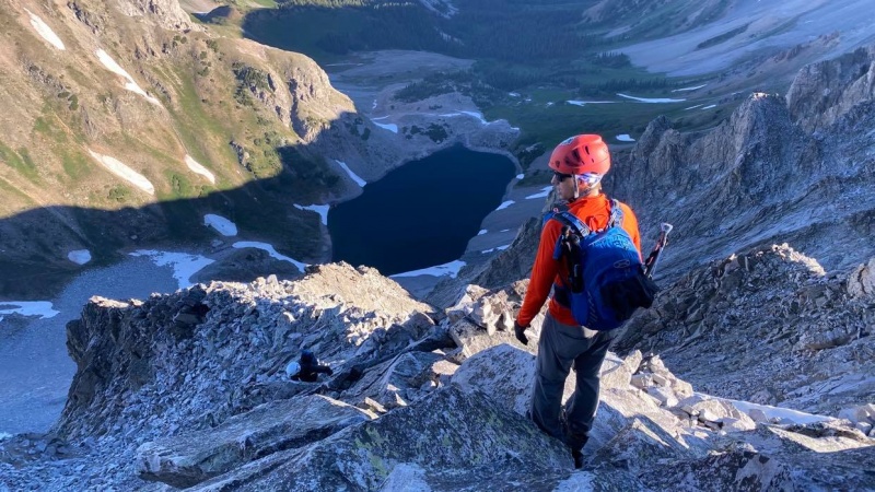
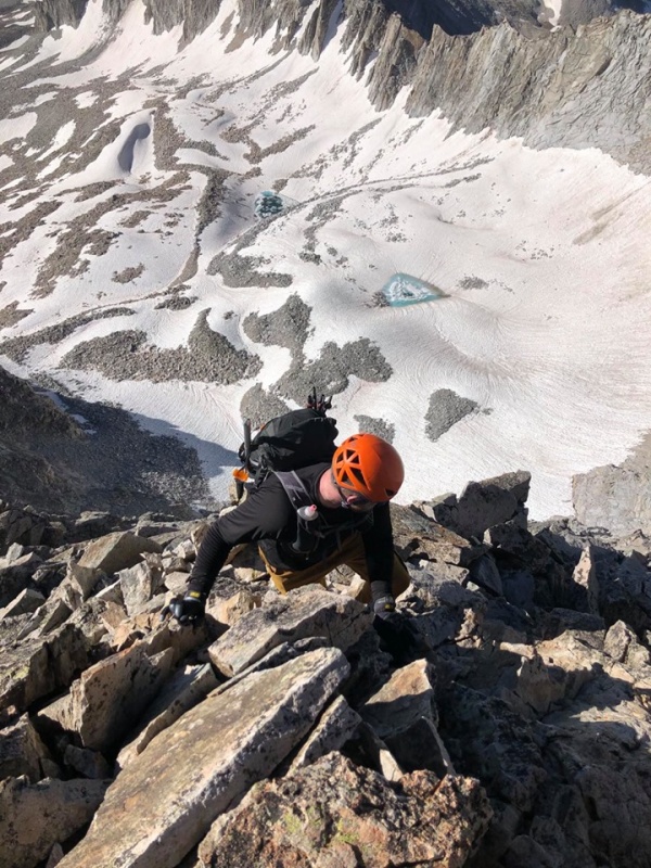
Skirting the ridge about 100' below the summit. No bowling ball here... this was actually about 1,000' of air right below me. This move had the highest pucker factor of the day for me (just as exposed as the knife edge or K2, but with looser rock)Below the summit, more careful scrambling remains. Note the loose dirt. Lots of air below. Watch for rockfall here... A group above (trying to follow ridge proper) were raining rocks down
We met up with a 20 year old Purdue student from Indiana named Nick, and this was his third 14er. He had done Elbert, Snowmass, and now was going for Capitol. While I certainly don't recommend tackling the 14ers in that sequence, I commend his efforts! He had a great attitude, seemed plenty fit, and most importantly, had humility and a clear respect for the mountain. He asked if he could tag along for help with route finding and we ended up doing most of the climb together. Nick, if you're reading this, congrats again!
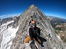
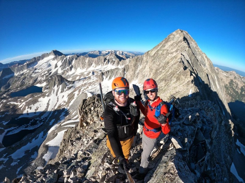
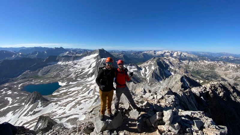
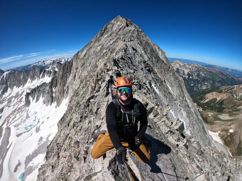
On the Summit with Patrick. Snowmass in the background
Obligatory GoPro shot on the knife edge... all smiles with a successful summit under our belts!
Here are my thoughts on some of the age-old Capitol questions and debates: (with as little bravado and as much honesty as possible)
Is Capitol the hardest 14er? When you combine the length of the approach with the fact that you are operating in a fully-committed and hyper-focused no fall zone for well over 4 hours, I would say yes (for me at least, so far). I think there are certain specific moves or other non-standard routes on different peaks that offer more difficult climbing, but as a whole, this is the most objectively difficult standard route on any 14er. It's a long and mentally taxing day.
Is Capitol the most dangerous 14er? I think I'm going to save that title for Little Bear. The objective hazard on Little Bear seems to be much higher and the rockfall is so much more random and unpredictable on that mountain. Both are dangerous mountains, but I'd give Little Bear the title of most dangerous. I did not seem to feel the level of fear or overall "heaviness" on Capitol as I did on LB. Put a different way, I would absolutely repeat Capitol, but you couldn't pay me to do LB again.
What about the exposure? If you don't like exposure, I'd stay away from Capitol until you can build up some exposure resistance. I think that should go without saying. It has more consistent exposure than probably any other standard 14er route and the knife edge is not the place to find out that you are freaked out by heights. However, I found the exposure to be much more manageable and -- dare I say -- fun than I was expecting. The knife edge was surprisingly solid and the rest of the mountain was doable, taking it one move at a time and testing each hold.
For those curious, here are some routes I would suggest if you're looking to get accustomed to exposure without diving straight into the deep end. A logical progression might look something like this:
- Wetterhorn (standard) - Sneffels' SW Ridge - Torreys via Kelso Ridge - Tour de Abyss - Wilson Peak - Wilson Traverse (El D to Mt Wilson)
Is K2 or the Knife Edge the crux? I found K2 to be equally as exposed but with tougher climbing than the knife edge. If you can confidently clear K2, you should have no trouble (difficulty-wise) with the rest of the route.
Some additional comparisons and thoughts: - The rock was much worse on Maroon Peak and Little Bear - Route finding was slightly more difficult on Maroon - For me personally, the Wilson traverse was freakier in certain spots (shorter and less exposed than Capitol, but had nightmarishly loose rock in a no-fall zone) - I spent so much time thinking about (and preparing for) the exposure, that I neglected to consider how mentally and physically taxing Capitol is. That, for me, was the hardest part.
This was an incredible climb on what is now one of my favorite peaks of all time. For me, this lived up to its reputation as the hardest standard 14er route, no doubt. This is not a peak that I would recommend climbing just to check it off your list to say you've "done the hardest 14er." But, if your goal is to climb all of the 14ers, this one is more within reach than you might think. I spent a lot of time worrying about Capitol, and it was becoming a cloud over my head on my 14er journey. While this peak deserves every ounce of respect you can give, I found it to be a much more pleasant trip than I was anticipating. And at the end of the day, isn't that why we do this?
Garmin Stats:
Total mileage: 19.5 mi (6.7 to/from camp, 6.1 RT on summit day) Total elevation gain: 5,489' (2,500' from TH to camp, 2,989' from camp to summit) Time from TH to camp: 3 hr 14 min Time from camp to summit: 4 hr 45 min RT time from camp to summit and back: About 8 hours with almost an hour on the summit (6 hr 40 min Strava moving time)
Thumbnails for uploaded photos (click to open slideshow):
Those couple pictures crossing that South face gave me the shivers. Most scary section of any 14er for me personally (as you know I did SW ridge on LB not the Hourglass). 4 hours of complete focus, that's for sure! Thanks for sharing, good to relive this one!
I was there the 12th, did it from th, was longest day in my life. I backpacked last weekend and summited again. Camping way to go. Definitely not a deathtrap but no picnic lol I didn't see any rangers, was worried they'd yell at me for sleeping in my car lol Did you see any bears?
Excellent report. Glad you had such a great experience on that mountain. Good to see ol Cap re-assessed and described again, and as well as you did. Super report!
Andrew - I'd agree with you 100% on that being the scariest section. My heart rate on my watch was even higher going down that section than it was going up! Haha
Gandalf - Twice in a month, that's badass! I'm a glutton for punishment, but not quite to that extent. Didn't see any bears at camp... just squirrels and drunk high school kids.
Great TP, mate. The photo with the caption "3:30 am wake up" is bloody beautiful, too.
I agree with you on Little Bear: Scariest for me, personally, and, I suspect, overall most dangerous. Not just rockfall, but tricky Class 4 climbing through the Hourglass verging on Class 5 if the center is wet/snowy and a fall there seems likely to be fatal.
I found Capitol to be surprisingly straightforward and, for me on that particular day, no big deal. I actually think some of the upper-slope/final pitch stuff is more crux-y than either the Knife Edge (easily crossed with a quasi-layback with your hands, working your feet along below on the west or is it south? I guess I could consult a map... side) or K2. Just my experience that day, which was a long one, all the way from Capitol Creek, so around 19 miles round-trip in one day. Got lost in the cows in the dark to start off.
What did you do with your pup while you summited? Just curious.
KD and Paul - Thanks for reading and for your kind words!
Clay/Pony - Totally agree with your statement about the south face below the summit. More exposure in spots than the knife edge + Looser rock... a spicy combo.
The pup and my wife hung out at the lake while Patrick and I climbed. They were a great greeting committee upon our return to camp.
Headed there this Labor Day. Thanks for the tip about the ranger as well as all the other details. Excellent job. Congrats!
Question - If we camp at Capitol Lake, is there a clear route (trail) to Snowmass or will it be backtracking to go get that one? I'd love to do both while I'm out there, but plan on doing Capitol.
To answer your question, no, there is no trail from Capitol to Snowmass and I would not recommend tackling Snowmass from Capitol Lake. Do these two peaks separately.
I feel like this great TR from Justiner gives a pretty good feel for what it would be like to get to Snowmass from Capitol (although he seems to have approached from a different drainage, not Capitol Lake): https://justinsimoni.com/2018/04/06/fastpacks-from-hell-capitol-snowmass-hagerman/
Maybe if he reads this, he can chime in with more firsthand info.
Thanks Jacer! Appreciate the info. Very excited to get out there (1 week away). Thanks again for a most awesome trip report!!
Caution: The information contained in this report may not be accurate and should not be the only resource used in preparation for your climb. Failure to have the necessary experience, physical conditioning, supplies or equipment can result in injury or death. 14ers.com and the author(s) of this report provide no warranties, either express or implied, that the information provided is accurate or reliable. By using the information provided, you agree to indemnify and hold harmless 14ers.com and the report author(s) with respect to any claims and demands against them, including any attorney fees and expenses. Please read the 14ers.com Safety and Disclaimer pages for more information.
Please respect private property: 14ers.com supports the rights of private landowners to determine how and by whom their land will be used. In Colorado, it is your responsibility to determine if land is private and to obtain the appropriate permission before entering the property.


")
")
")
")
")
")
")
")
")
")
")
")
")
")
")
")
")
")
")
")
")
")
")
")
")