Download Agreement, Release, and Acknowledgement of Risk:
You (the person requesting this file download) fully understand mountain climbing ("Activity") involves risks and dangers of serious bodily injury, including permanent disability, paralysis, and death ("Risks") and you fully accept and assume all such risks and all responsibility for losses, costs, and damages you incur as a result of your participation in this Activity.
You acknowledge that information in the file you have chosen to download may not be accurate and may contain errors. You agree to assume all risks when using this information and agree to release and discharge 14ers.com, 14ers Inc. and the author(s) of such information (collectively, the "Released Parties").
You hereby discharge the Released Parties from all damages, actions, claims and liabilities of any nature, specifically including, but not limited to, damages, actions, claims and liabilities arising from or related to the negligence of the Released Parties. You further agree to indemnify, hold harmless and defend 14ers.com, 14ers Inc. and each of the other Released Parties from and against any loss, damage, liability and expense, including costs and attorney fees, incurred by 14ers.com, 14ers Inc. or any of the other Released Parties as a result of you using information provided on the 14ers.com or 14ers Inc. websites.
You have read this agreement, fully understand its terms and intend it to be a complete and unconditional release of all liability to the greatest extent allowed by law and agree that if any portion of this agreement is held to be invalid the balance, notwithstanding, shall continue in full force and effect.
By clicking "OK" you agree to these terms. If you DO NOT agree, click "Cancel"...
Thanks to Monster5's wry trip report and goregalore's "Mountaineering in the Gore Range" for the beta. Besides those sources I could not find much about this traverse.
I recruited my friend Nikki to join me promising a 6 to 8 hour day high in the alpine amongst some of the most beautiful peaks in Colorado. I failed to mention the complex route finding, obligatory Gore bushwhacking, and hummingbird-sized mosquitos. There's no easy access to the Slate Creek Trail for the start of the ascent from Upper Slate Lake thanks to the massive Powell Ranch on the eastern edge of the Gore. After studying the map and cursing the private landowners for a bit, I decided on arranging a shuttle. Our route was Harrigan Ck to GRT to Slate Ck to LMNO to Lost Lake to GRT to Brush Ck. And the Harrigan Ck parking lot is day use only so you'll have to be ambitious to utilize this route.
APPROACH
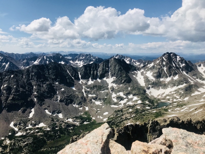
The run to the end of Upper Slate Lake and the start of the ascent to L was 12mi with about 3000ft of elevation gain taking us 3hrs. The turnoff to Slate Ck is preceded by a log crossing of the creek itself and an old cabin. Slate Ck Trail climbs west on a thin path overgrown by diverse wildflowers tracing a creek that alternates between oxbows and raging waterfalls. It was really quite pleasant except for the shoe soaking, skin itching morning dew. The trail abruptly ends at the eastern end of the lake in the heart of the cirque of the drainage with TSRQPJKLMNO overhead. Intermittent social footpaths provided access to the western end along the southern edge of the lake. From there Peak L was readily identifiable to the north.
PEAK L
We hopped across the creek upstream of the lake into a thicket of willows and made our way to a talus field to begin the 3000ft climb to L. The steep slope has a combination of slabs, talus and grass.
I had a good idea of where the knife edge began SW of L's summit but we found ourselves obstructed by a large steep snowfield along the course of our intended route. We opted to skirt it climber's right. This led to a series of chimneys and cracked slabs of increasing difficulty as we climbed higher.
S-R-Q
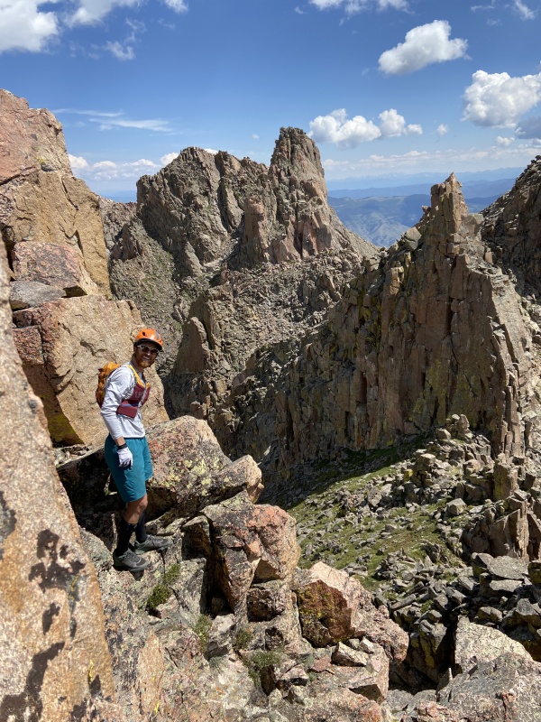
Maybe a good time to throw helmets on. I soon realized we were directly below the summit when I peeked around a corner of a ledge and found us high on the slab face beneath the standard 3rd class knife edge. Oh well, onward and upward.
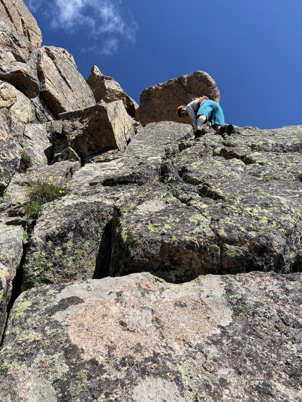
Crack ascending to the crux dihedralNikki overcoming the last of the 4th+ climbing below L
To save weight, I had passed on a rope - so I was really hoping the difficulty would not exceed our comfort level for soloing. The crux to gain the ridge was a 5.easy layback around a bulge at the top of a dihedral. It was a little exposed but solid. That spit us out right below the summit block, below and beyond the knife edge. Great bypass!
The summit block never exceeds 3rd class. It looks intimidating in photos but it's easy scrambling.
The summit of Peak L is tiny and has a little cairn atop cradling a summit register. Decided to actually sign this one since we'd had to really earn it. We summit Peak L at 1045, nearly 5 hours after we started. Looking ahead to the Thumb and Guylseman, Nikki admonished me for estimating a 6 to 8 hour day. The Gore has a tendency to foil the best laid plans.
GORE THUMB
Several nonlinear gendarmes rise like fountains along the broad, complex mastiff between Peak L and Guyselman. Despite having uploaded the route on Viewranger, Gore Thumb was utterly indistinguishable from the other gendarmes. I realized it was the "3rd tower" but we couldn't even identify which tower was actually the 3rd. After some waffling, we just decided to climb the two tallest gendarmes adjacent each other.
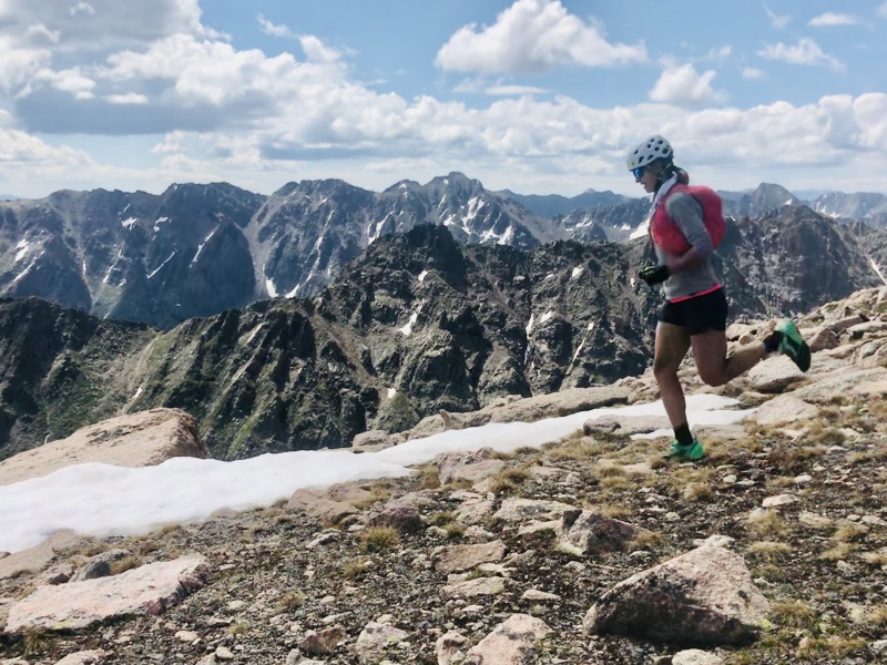
A brief runnable section between L and Gore Thumb! Peak S behind with the XYZ ridge beyond.Gendarmes aplenty
The first we summited had a tricky exposed mantel to a tiny summit. Probably not that one. For the second we bypassed a sheer face on the west to access a blocky 3rd class ridge up the NE side. From the summit it felt like the tallest point between L and Guyselman. My .gpx track uploaded to caltopo later confirmed this was the Gore Thumb.
GUYSELMAN (PEAK M)
The ridge to Guylseman required some bobbing and weaving between ridge proper and west bypasses never exceeding 3rd class. But we became disoriented in the process of climbing over there, overshooting the summit and landing on a false summit to the west. We backtracked along an east ridge that landed us atop a 20 ft sheer wall boxing in a gully that split the false summit and the true summit. Beyond losing 200 ft to bypass the long fin way off ridge, there was no way around it. Because the exposure wasn't deadly, we decided to traverse the wall on thin holds up ridge to a point where the gully intercepted the wall. It went at 5.moderate. Definitely not standard. Summited at 1220.
PEAK N
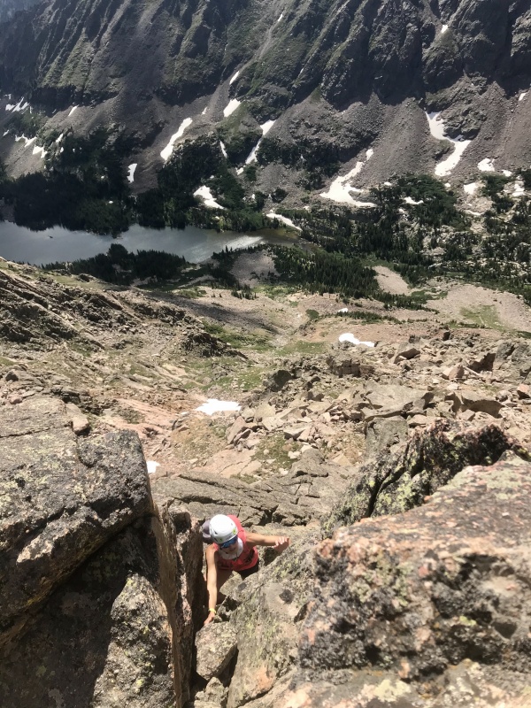
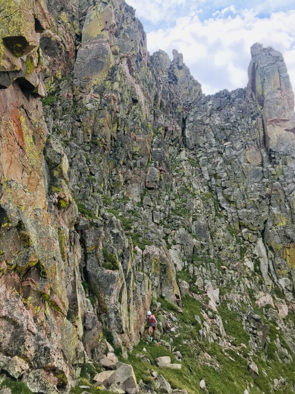
Instead of reclimbing the wall feature on our way off Guyselman, we downclimbed the aforementioned gully around the fin assuming there would be bypasses all the way to N. But in the process of downclimbing, we overlooked the easiest way off Guyselman closer to the ridge. This proved costly. We lost a couple hundred feet to the SW off ridge to bypass the fin. Then began contouring north on grassy ledges and loose gullies while separated from the ridge proper by cliffs above. Soon the only options to progress were a downclimb of cliffs to the west, a loose 100+ foot chimney downclimb north, or backtracking to Guyselman. Reluctantly we opted for the chimney. We battled lichen and loose blocks while stemming our way down facing inward. This was the most gripped we'd been all day. Risk fatigue was starting to set in. Luckily the difficult terrain started to relent. We were able to make our way back to ridge proper through 3rd cl gullies and ledges. We ascended moderate grass up to N, summiting at 1330.
Sketchy chimney downclimb behindDon't know if I'm peeing or what here. Gore Thumb and Peak L in the background.
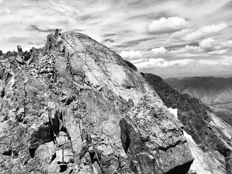
Peak O
The view of O from N is daunting.
Peak O from the N saddle
Continued complexity in more towers and fins along the ridge reveals itself, with a shear face dropping to O's SE Neither of us could wrap our heads around more exposed 4th+ climbing. We reluctantly started downclimbing from N, bypassing a first tower west then continued traversing north. Fatigue was setting in. Our progress north was haulted by a 40ft slab. We briefly entertained thoughts of bypassing the slab by descending further west. But I didn't have the energy or patience for more route finding far below ridge. I turned inward and started descending the ledge switching back and forth on a series of cracks for holds. It was probably 4th class but felt harder with the exhaustion. Nikki followed and we soon found ourselves at the lowpoint of the saddle. Most of the complex terrain was behind us or below us. We made our way through some ledges bypassing the last fin and enjoyed an easy blocky climb to the summit at 1400.
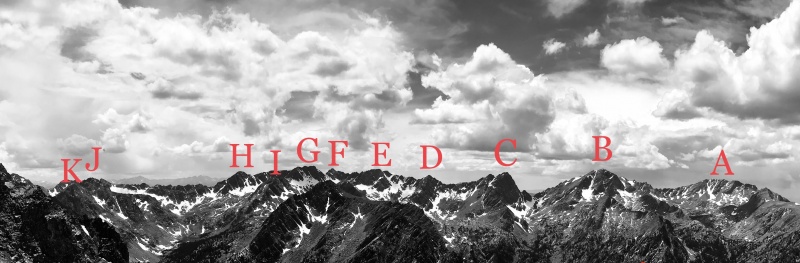
View from O
DESCENT TO LOST LAKE
Peak O provided my favorite views of the day. A panorama from west to south held Eaglesnest, Powell, Ripsaw and the Saw with the Elephant inset. Far below in the Black Creek drainage to the NE, the private ranch could be seen on the east end of Black Lake. Up ridge behind, steep snow choked couloirs descended from N's summit block. And down a steep talus field to the NE was little Lost Lake, our destination for salvation. It felt close. It was not. We descended about 3000ft of steep loose talus that finally gave way to flat meadows. I convinced myself that these meadows would bring us to the lake. No. Instead they gave way to a thick, riparian deadfall ridden classic Gore bushwhack. Our knees and flesh took a beating from the combination of deadfall hurdling and the assault by relentless thorny branches. We finally emerged from the darkness on the shores of Lost Lake at 1510.
EXIT STAGE EAST
Jumped on the Lost Lake trail and started running. We both needed to get back. Covered the next 6mi in about an hour arriving back at the car at 1615 with a profound sense of accomplishment and exhaustion.
My GPS Tracks on Google Maps (made from a .GPX file upload):
Nice job.
I ran L two summers ago (without the complicated traverse) ... one of the best runs / scramble combos out there.
Can't go wrong with the Gores.
I don't know if I could do just L alone as a day trip. Been eyeing that one for a while, but figured it might be a 3-day backpack for me! Always impressed with how fast/fit some folks in this community are!
You'd be surprised how fast you can go Tornadoman when you travel a little lighter. I feel like the Gore is all planning and execution. Can't get away with too much fapping in there.
I enjoyed your report, that is a big day. Just asking about Harrigan Creek parking as day use only, I was just there and saw no signs to indicate that. Need to know for future stuff. Thanks
Sent you a PM planet54. That was my understanding from a friend years back but I did not look for a sign so I could be mistaken.
Caution: The information contained in this report may not be accurate and should not be the only resource used in preparation for your climb. Failure to have the necessary experience, physical conditioning, supplies or equipment can result in injury or death. 14ers.com and the author(s) of this report provide no warranties, either express or implied, that the information provided is accurate or reliable. By using the information provided, you agree to indemnify and hold harmless 14ers.com and the report author(s) with respect to any claims and demands against them, including any attorney fees and expenses. Please read the 14ers.com Safety and Disclaimer pages for more information.
Please respect private property: 14ers.com supports the rights of private landowners to determine how and by whom their land will be used. In Colorado, it is your responsibility to determine if land is private and to obtain the appropriate permission before entering the property.


")
")
")
")
")
")
")
")
")
")
")
")
")
")
")
")


