Download Agreement, Release, and Acknowledgement of Risk:
You (the person requesting this file download) fully understand mountain climbing ("Activity") involves risks and dangers of serious bodily injury, including permanent disability, paralysis, and death ("Risks") and you fully accept and assume all such risks and all responsibility for losses, costs, and damages you incur as a result of your participation in this Activity.
You acknowledge that information in the file you have chosen to download may not be accurate and may contain errors. You agree to assume all risks when using this information and agree to release and discharge 14ers.com, 14ers Inc. and the author(s) of such information (collectively, the "Released Parties").
You hereby discharge the Released Parties from all damages, actions, claims and liabilities of any nature, specifically including, but not limited to, damages, actions, claims and liabilities arising from or related to the negligence of the Released Parties. You further agree to indemnify, hold harmless and defend 14ers.com, 14ers Inc. and each of the other Released Parties from and against any loss, damage, liability and expense, including costs and attorney fees, incurred by 14ers.com, 14ers Inc. or any of the other Released Parties as a result of you using information provided on the 14ers.com or 14ers Inc. websites.
You have read this agreement, fully understand its terms and intend it to be a complete and unconditional release of all liability to the greatest extent allowed by law and agree that if any portion of this agreement is held to be invalid the balance, notwithstanding, shall continue in full force and effect.
By clicking "OK" you agree to these terms. If you DO NOT agree, click "Cancel"...
I've had the X-Rated couloir on Sayres Benchmark on my radar for a while now. I never noticed it the couple of times I climbed nearby fourteener La Plata Peak, but once I saw pictures of Sayres' north face I knew I had to climb it. In addition to Sayres I also planned on tagging two nearby thirteeners - Point 13,460 B and Point 13,300 F - as well as a twelver, Point 12,601. The three additional peaks were essentially just the bumps on Sayres' northwest ridge. I kept a close watch on conditions and when they were finally good I went for it.
I started around 4:45am after a night with a good, hard freeze, and began up the La Plata Trail towards La Plata Peak. I crossed over creeks three times on smaller and smaller bridges: first a large one for vehicles across North Fork Lake Creek, the second across a sturdy foot bridge over South Fork Lake Creek, and then across a log bridge over the unnamed creek draining La Plata Gulch. I kept a close watch over my direction of travel up La Plata Gulch, as I didn't want to inadvertently take the trail too high up La Plata Peak's northwest ridge and have to backtrack. The trail steadily gained elevation and was mostly dry, which made for quick travel. Once the trail flattened out prior to turning up the ridge I just cut off the trail and into the forest. My elevation was almost exactly 11,000 feet, and Sayres Benchmark wasn't yet visible from where I left the trail.
Good trail that was a pleasant, early morning hike.
As I hiked up the gulch I kept an eye on Point 12,601, the terminus of the ridge I'd be descending. I wasn't sure exactly what the best descent would be off the twelver so I kept looking for various ways down.
Point 12,601's north slopes, which I could probably descend if desired.12,601's east gully. It's difficult to discern but a couple of small cliffs in the gully's center would probably prevent an easy descent.
Shy Sayres eventually showed itself with early morning light falling on its upper reaches.
Good morning to you, too!
The off-trail hike was a bit of a bushwhack but not as bad as the reputation that preceded it. For the most part it was very straightforward, as the upper gulch was mostly flat, and though there was no trail the willows weren't really that awful. Rock hard snow certainly helped, and I soon found myself in the final stretches. The willows here were certainly very thick, so I hiked down to the snow covering the creek and then just hiked directly up it since it was way easier.
A short bushwhack to the snowy creek, and then like lightning up the middle.
The views of the numerous couloirs on Sayres' north face were splendid.
Sayres Benchmark's north face in all its glory. Grand Central is the big line right of the summit, X-Rated is the direct line up the middle with the small shadows.Looking back down La Plata Gulch from my gear up spot.
I gleefully hiked to the bottom of the couloir and plopped down on a rock. I got my ice axe and crampons out, and strapped into the latter, cinching them down nice and tight. It's time to goooooo!
Looking directly up the couloir. At various points from within the couloir itself the path ahead or behind may not be visible in the bends.
The apron of X-Rated started off easy but quickly reared back into Moderate Snow and then Steep Snow and stayed there to the summit ridge. I switchbacked up the lower portion and eventually began facing in and front pointing in piolet appui (middle dagger) position. I quickly wished I had a second axe or an ice tool but never felt like it was a necessity, it would have just been extra security.
Enemy at the gates.Progressing easily.
Snow in the couloir was variable, trending towards bulletproof. About half the steps I kicked went right in and about half required three or four kicks in order to punch deep enough to feel secure and balanced. Most importantly though is that it was stable. This stuff wasn't going anywhere, which made me feel much better on such a steep line.
About 800 feet up I came to the first of two short sections of melt-exposed rock. This is also where the angle of the couloir reached its maximum, which was a rather spicy combo. I probably only spent a minute or two climbing through the first rocky section but it felt like a lot longer as I searched for the best way through. I wish I had taken a couple of good pictures of this section, but that was about the last thing on my mind as I hacked out the ice around the rocks looking for holds I could use, ultimately just grabbing the ice with one hand like a rock climbing jug (hey, it's probably at least as solid as a jug found on any random Elk peak!) I'd guess this section was at least 50 degrees if not more, and it really kept my focus.
Looking up at the first rocky section, which I had to make a couple of funky moves through.Looking down at the rocky choke.
The second rock band came shortly after the first, though it was melted out more and was a little less steep. The rocks here were covered in gravel but were more spaced apart, meaning I could stay more on snow than being forced to choose between the two.
Above the second rock band. The big rock in center made for a good, if narrow, platform to catch my breath on.
Above this second rock band the angle relented but only slightly, enough for me to feel less tense about making perfect steps every time. A few more rocks poked out of the snow ahead but the couloir had widened enough that I could just bob and weave around them entirely, avoiding the moments of intense focus required for the rock below me.
Almost to the top. The cornice is visible just above the rock near the center. For reference, the big rock far up in center is the same as the one in the photo below, and is also visible about 1/5 of the way from the top in the photo of the full face taken in La Plata Gulch.Around the big rock to the right.
A couple hundred more feet up the couloir and I was next to the big rock, which also marked the boundary between Steep Snow and Moderate Snow; below and above, respectively. I breathed a sigh of relief as I climbed up the final ramp to the summit. X-Rated had been a superb, exciting, and intense line and I only had a little bit more to go to the summit.
Looking up the last ramp where things lowered significantly in angle. I could basically walk up this instead of front point. The blob rock is the one on the left.Looking down what little of the couloir is visible given how steep it is.Small cornice at the top. I didn't get close to it but I'm sure it was frozen solid.Looking down the last Moderate Snow ramp before the summit ridge.Summit ridge.
The final summit ridge was easy and not all that exposed, unless venturing to peer down the north face. I was a little tired and a lot elated sitting on the summit. X-Rated had been 1,800 feet of pure joy. I'd call it a classic, even, and it's a route worth repeating.
La Plata Peak looking absolutely lumptastic. Note the faint trail between the two peaks - Gerry Roach says the ridge is a bad idea, but apparently plenty try.Looking towards Winfield with the Three Apostles in center and Huron Peak just to the left.
There was a short, snowy traverse to Sayres' western summit that I kept my crampons for, and after that things dried out enough that I could just boot most or possibly all of the remaining route. I scampered across the ridge and then packed up my crampons and ice axe.
Point 13,460 B is the somewhat indistinct, snowy peak left of center, and Points 13,300 F and 12,601 are farther right along the ridge.
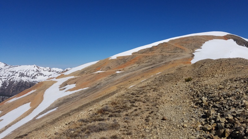
Most of the ridge to 13,460 B was Class 2 scree and talus, and the first two thirds was quick, easy, and not really noteworthy, with exception of the bright red rock and road that snaked up from Sayres Gulch. I can't imagine the road is actually driveable, as it looked very loose and in a state of disrepair. I couldn't make out any recent (past year or so) vehicle tracks.
Pretty red rock.Bizarre little ice mycelium.Secondary set of roads above the first, redder set.
From atop the red rock I could make out 13,460 B's summit and the rough towers that stood in the way.
Scruffy.
The first few towers were small and rotten but easy enough to get around on the left. After the towers a small catwalk-like protrusion stuck out, and this too was bypassed on Class 2+ terrain to the left.
This didn't look too fun or safe to go over, so I went left around it.The backside of the catwalk, which looks like it would have had some more difficult scrambling off of it.
There was a little more Class 2 talus and elevation gain after the catwalk, but 13,460 B was a few minutes away tops.
Point 13,460 B's rocky summit.Looking ahead at the ridge to 13,300 F (taken after descending slightly, since the ridge wasn't fully visible from 13,460 B's summit).Looking back across the red ridge to Sayres. Now the X on the north face is very apparent. Grand Central is the wide strip of snow just right of the summit.
The first two thirds of the 13,460 B-13,300 F connecting ridge was - like the ridge prior - easy and fast, mostly tundra. Some snow going north right off the summit was just softening up and posed no safety or difficulty problems.
Tundra stroll in the high country.Looking back at 13,460 B.
Near 13,300 F's summit some more rocky outcroppings appeared, this time on very solid granite. Passing around the first on the left and then directly over or through the others, I was able to keep this section at a fun, stable Class 2+.
Up the obvious weakness on the left.Mixed, pleasant terrain.The summit (left) of Point 13,300 F.Point 13,460 B and the ridge to Sayres.
I had one peak left, diminutive Point 12,601, and this one was ranked, unlike 13,300 F.
This might be a 12,601 foot tall mountain but it's dwarfed by everything around it.Point 12,601's southwest face and the ridge to the summit.
There was quite a bit of snow all the way down to the saddle, and it was steep enough that I didn't like plunge stepping it, so I put my crampons (my only traction) back on and skipped down to the saddle.
Looking up Point 12,601's south ridge. Not as bad looking from this angle.
At the saddle I once again took my crampons off and left my pack behind, since I'd be coming back to the saddle and then deciding whether to descend east or west. The hike up 12,601 was simple and quick, and I stayed below the ridge crest the entire time just sidehilling up in an arcing pattern. The terrain was a bit loose and sandy, but not terribly so, and not nearly as steep as it appeared from a distance.
12,601's rocky (surprise, surprise) summit.Sayres and Point 13,300 F.
The descent back to my car would prove to actually be the crux of the day. I had two options: a known eastern descent back into La Plata Gulch which included what looked like a Class 4 down climb on questionable rock replete with large cornice (parts of which had already broken off, which didn't inspire confidence), or an unknown descent west into the forest in Sayres Gulch. The former was a known quantity if I could get down safely, since there was a trail, and the latter had a road (FS 391). I chose the latter based on the crappy looking down climb east, and just hoped I wouldn't find cliffs hidden in the trees or something showstopping like that. (A third option would have been to go north down/under 12,601 back to La Plata Gulch, but seeing it from that side in the morning it didn't look so hot.)
Looking down into the forest from 12,601's summit.
I returned to the saddle, picked up my pack, then contoured across a large snowfield and down into the trees. Things were quite steep most of the way down and the forest was full of patchy, mixed quality snow, small streams, and just stupid amounts of deadfall. I never did find any cliffs, fortunately, but I got my money's worth on the bushwhack out. This was one of the more annoying descents in recent memory. My friend Whiley, who climbed these peaks from Sayres Gulch several weeks later, totally agreed with the assessment of the awful bushwhack; it goes, but it also sucks hard.
A metaphor for both the ascent route as well as to stay "what the hell is wrong with you, get out."So thick and dense it's literally dark in this forest.
After what felt like forever I popped out of the forest next to South Fork Lake Creek. There was no way across the creek, which was probably 50 feet wide, waist deep, and swift, so I just paralleled the creek all the way back to the trail near the trailhead. This was very pleasant and made up for the awful descent through the trees. There was no trail until I got very close to the La Plata Trail but I did pass an old cabin and a fire ring, so I knew others had been up here at least.
South Fork Lake Creek. "Lackawanna" is the peak on the right.The lair of a miner.
Near to the official trail I had to stay above the steep canyon walls of the creek as it dropped dramatically towards SH-82; this was the final unknown, and there was a nice, flat bench that continued to the trail before it switchbacked down and over the foot bridge, so there was no need to worry about the steep terrain above the creek. I returned to my car without issue, the only one at the trailhead. What a great route this turned out to be, and yet another amazing snow climb that should be on everyone's radar!
Point 13,460 B, Point 13,300 F, Point 12,601 (right to left) from La Plata Trailhead.
Statistics
Climbers: Ben Feinstein (myself) Trailhead: La Plata Total distance: 12.74 miles Total elevation gain: 4,983 feet Total time: 9:06:43 Peaks: Two ranked thirteeners, one unranked thirteener, one ranked twelver
Sayres Benchmark, 13,743'
Point 13,460 B
Point 13,300 F (unranked)
Point 12,601
Splits:
Starting Location
Ending Location
Via Time (h:mm:ss)
Cumulative Time (h:mm:ss)
Rest Time (m:ss)
La Plata Trailhead
Bottom of X-Rated Couloir
2:30:12
2:30:12
10:47¹
Bottom of X-Rated Couloir
Sayres Benchmark
1:35:25
4:16:23
0:00
Sayres Benchmark
Point 13,460 B
1:24:33
5:40:56
6:50
Point 13,460 B
Point 13,300 F
0:26:12
6:13:58
8:08
Point 13,300 F
Point 12,601
0:45:52
7:07:58
0:00
Point 12,601
La Plata Trailhead
1:58:45
9:06:43
Trip End
¹Gearing up.
Version history:
Date
Notes
June 16, 2020
Initial publication.
June 23, 2020
Fixed several typos.
My GPS Tracks on Google Maps (made from a .GPX file upload):
I think it took me 45+ minutes to move less than half a mile... I felt like nature was swallowing me whole, regurgitated me to chew me up, and finally spit me back out once I reached South Fork Lake Creek. Jumping into the waist deep orange creek was such a relief.
I have come to expect such atrocious bushwhacks from the lower & lesser visited peaks but this was some next level shit for 13ers!
I found the bushwhack to not be bad at all. Crossed the creek on a nice log just after leaving the La Plata Peak trail. From there I gained a bit of elevation and stayed above the willows on the west side of the creek the whole way up. There were even old trail segments or game trails in parts.
@HikerGuy: I think we're talking about two different bushwhacks here. There's the bushwhack on the ascent up La Plata Gulch to the base of Sayres' north face, which as stated, was not that bad. Then there's the truly awful bushwhack descending west off 12,601. Once at the creek (South Fork Lake Creek, not the unnamed creek in La Plata Gulch) it's not a bushwhack anymore, but the couple thousand foot descent to that point is my new benchmark for terrible bushwhacks.
You didn't delve into the X much in the report that I saw. Plenty of opportunities to increase the rating. I'm disappointed.
Although the bush comments in the replies here gets you closer. Try harder, feinsteener. Harder.
(I drove the shaft; just the tip would penetrate; c'mon you can do it)
I'll reread, just in case I missed something.
I mean there was some bush and some whacking, and some bushwhacking, but no whacking in the bush if you nah'mean, nah'mean? That just wouldn't do on this family friendly site.
PS There was nothing PG about how hard I dominated poor Sayres. I had to censor it, after all.
So you trimmed the bush when you were whacking away at it? That's nice.
I didn't get the memo on the family friendly site...and your report opened with the parental advisory!
haahaha...great climb though. I loved walking down the valley and staring at the face...just awesome and photogenic!
I could have uploaded these photos to Pornhub without the warning but it just didn't seem appropriate to do that here. Everyone who's part of my Rock Hard Mountain Porn Fan Club knows what they get themselves into with my reports, but for everyone else I gotta give them a heads up before I turn them into a drooling, quivering mess.
Seriously classic climb though. When I finish the 13ers this is a line that I'll repeat every so often because it's just amazingly good.
Tipper Gore, proto-Karen of the 90s, is a major figure in my youth. As a rebellious metalhead I made it my life's journey to piss off my parents and buy basically every album emblazoned with a Parental Advisory sticker I could spend my precious allowance on. Some classics include Agoraphobic Nosebleed's Frozen Corpse Stuffed with Dope, Cattle Decapitation's Humanure, and pretty much anything by Cannibal Corpse, Slayer, Pantera, anything subversive and extreme. Turns out I ended up a total nerd with awesome parents who had a great sense of humor about the whole thing, so the joke's really on Tipper after all. Fuck yeah. Hey Tipper!
This has been your public service announcement.
Caution: The information contained in this report may not be accurate and should not be the only resource used in preparation for your climb. Failure to have the necessary experience, physical conditioning, supplies or equipment can result in injury or death. 14ers.com and the author(s) of this report provide no warranties, either express or implied, that the information provided is accurate or reliable. By using the information provided, you agree to indemnify and hold harmless 14ers.com and the report author(s) with respect to any claims and demands against them, including any attorney fees and expenses. Please read the 14ers.com Safety and Disclaimer pages for more information.
Please respect private property: 14ers.com supports the rights of private landowners to determine how and by whom their land will be used. In Colorado, it is your responsibility to determine if land is private and to obtain the appropriate permission before entering the property.


")
")
")
")
")
")
")
")
")
")
")
")
")
")
")
")
")
")
")
")
")
")
")
")
")
")
")
")
")
")
")
")
")
")
")
")
")
")
")
")
")
")
")
")
")
")
")
")
")
")