Download Agreement, Release, and Acknowledgement of Risk:
You (the person requesting this file download) fully understand mountain climbing ("Activity") involves risks and dangers of serious bodily injury, including permanent disability, paralysis, and death ("Risks") and you fully accept and assume all such risks and all responsibility for losses, costs, and damages you incur as a result of your participation in this Activity.
You acknowledge that information in the file you have chosen to download may not be accurate and may contain errors. You agree to assume all risks when using this information and agree to release and discharge 14ers.com, 14ers Inc. and the author(s) of such information (collectively, the "Released Parties").
You hereby discharge the Released Parties from all damages, actions, claims and liabilities of any nature, specifically including, but not limited to, damages, actions, claims and liabilities arising from or related to the negligence of the Released Parties. You further agree to indemnify, hold harmless and defend 14ers.com, 14ers Inc. and each of the other Released Parties from and against any loss, damage, liability and expense, including costs and attorney fees, incurred by 14ers.com, 14ers Inc. or any of the other Released Parties as a result of you using information provided on the 14ers.com or 14ers Inc. websites.
You have read this agreement, fully understand its terms and intend it to be a complete and unconditional release of all liability to the greatest extent allowed by law and agree that if any portion of this agreement is held to be invalid the balance, notwithstanding, shall continue in full force and effect.
By clicking "OK" you agree to these terms. If you DO NOT agree, click "Cancel"...
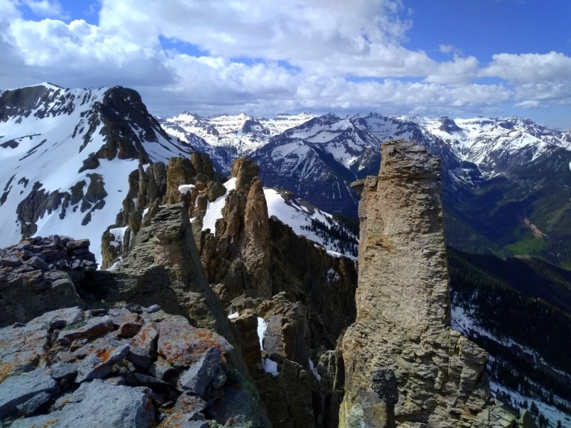
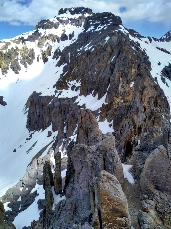
The numerous aiguilles of the Saint Sophia Ridge were visited by several members of the San Juan Mountaineers. The entire length of the ridge was traversed along the base of the pinnacles. None of them was ascended, but many will offer extremely good climbing if one will disregard the frequent outcroppings of loose rock. While a few of the points may be unclimbable, others, among the more solid of the lot, should go. At any rate the ridge is worth visiting.
Dwight G. Lavender American Alpine Journal 1933
Inspiration: Saint Sophia Ridge, 29 May 2019
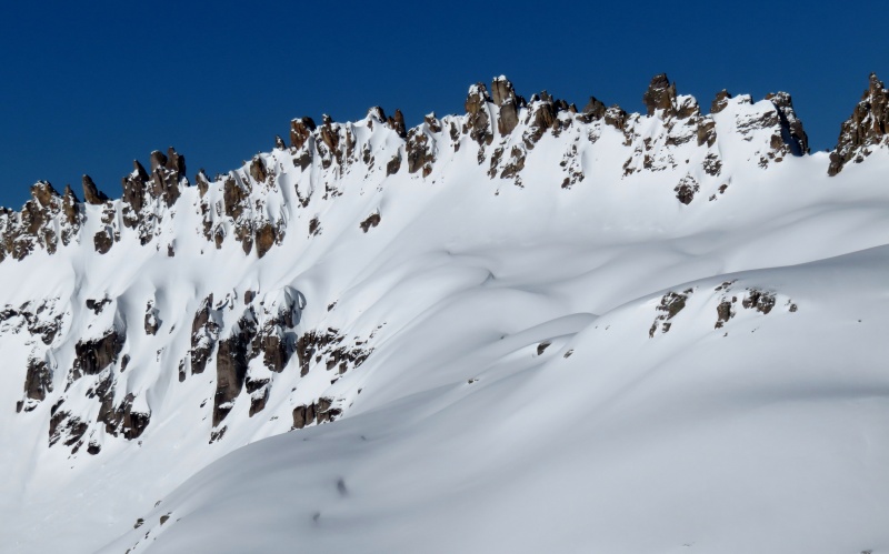
In the dim, flat light of a cloudy morning, the crumbling spires of Saint Sophia Ridge loom threateningly over Governor Basin like an army of missile troops waiting in ambush, preparing to rain down their chossy payload on any who seek passage beneath their lofty gaze. We tiptoe quickly up the basin towards them, hoping to catch them dozing in the cold. The only sound is the rhythmic crunch of frozen snow underfoot.
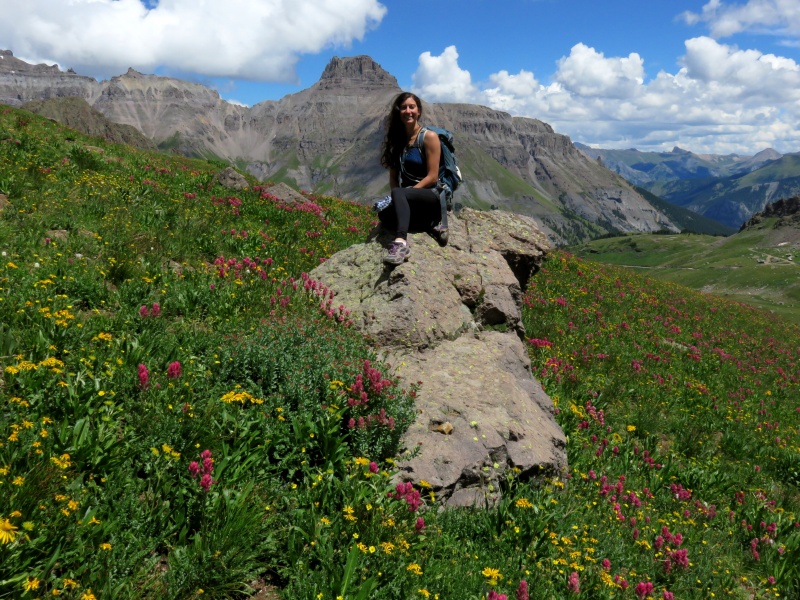
Kylie and I climbed Saint Sophia Ridge in the summer of 2016, and the scene was very different then. We had driven nearly to the Virginius Mine, and a short hike up steep grassy slopes blanketed in wildflowers and chirping pikas yielded a bench of rolling talus beneath the toothy ridge.
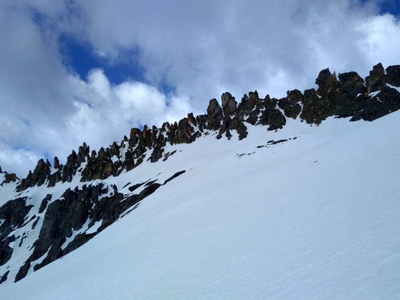
Last spring from a nearby peak I admired the beauty and contrast in the soft curves and smooth texture of a heavy winter's snow flanking the row of jagged towers that seemed to sprout from it, like the chaotic frothing of a wave about to break and crash down upon the basin. The access gully had been transformed into a funnel of snow that looked far more amenable than the hardpan flume we had groveled up to reach the summit tower years earlier.
Despite that unpleasantness, we had enjoyed the short technical pitch to the summit--not too long, not too difficult, and reasonably protected. So with enthusiasm buoyed by a remembered fondness for the experience and high hopes that spring conditions will aid our ascent, we're now staring up the snow-plastered gullet.
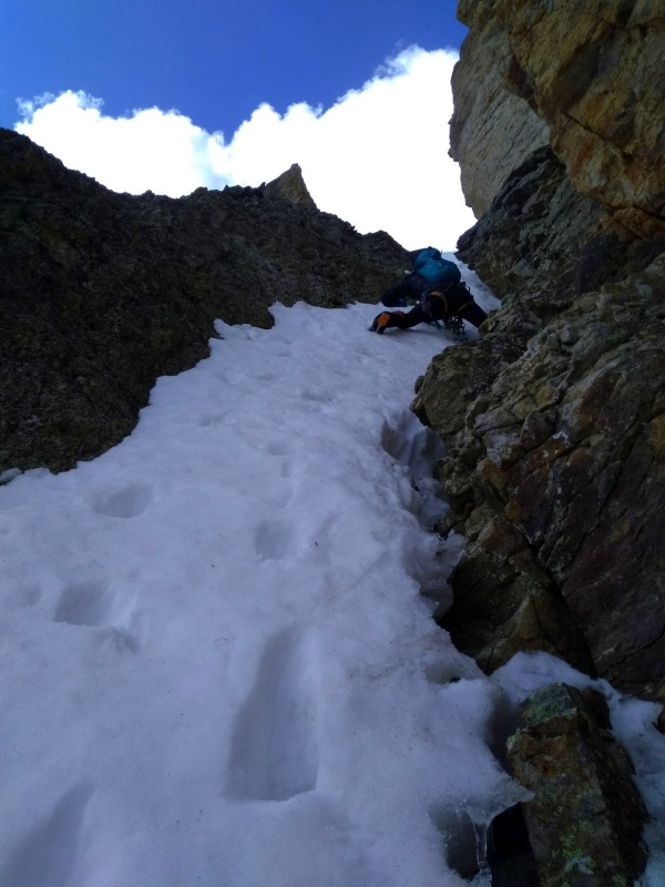
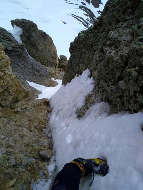
After a cold night, the snow is so good we've worn our crampons almost from where we parked at the creek crossing around 11,100', where someone with a much bigger rig than mine had failed to make progress through the deep snow on the far side of the creek. We don our helmets and harnesses and launch up the chute.
Having spent several minutes on the approach debating the relative merits of a traditional piolet versus ice tools, we're immediately given a chance to test our positions. I've brought a short straight-shafted aluminum axe--a decision I'd been sure I would regret as the steep ramp loomed closer--and Kylie has her tools. The snow in the gully consists of poorly-bonded crystals covering hard ice or rock a foot or so down. Too deep to swing, not consolidated enough to plunge: We're both wrong.
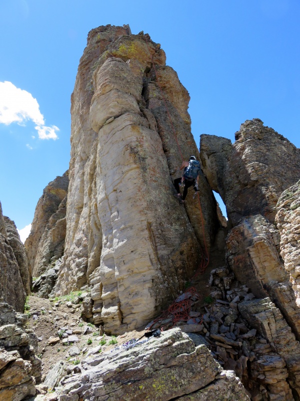
At any rate, the gully is short, and it's still supportive enough to kick steps and narrow enough to brace against the stacked choss lining the opposing walls. At the top, before reaching the ridge, we step right around the split tower, wondering if anyone has climbed the juicy offwidth direct.
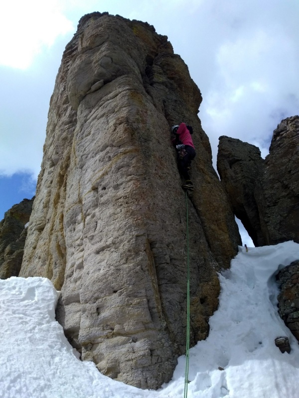
On the north side of the tower, Kylie decides she'll take the lead this time, so we stage the belay and she's off. Getting established in the crack proves trickier in mountaineering boots than in hiking shoes, and as she struggles I muse that she's about to get the first second ascent of Saint Sophia Ridge. Soon enough she's cranking her way up. She makes an exposed mantle onto a platform thirty feet up before dispatching the final short headwall that leads to a small ledge and the anchor. I follow in my usual following form.
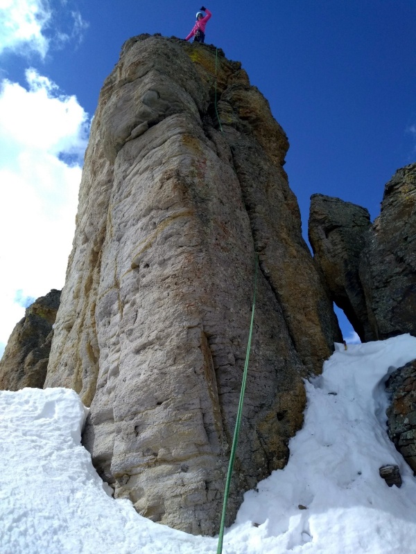
A few feet higher we scramble gingerly onto the precarious summit, and I recall seeing a photo of Abe squinting into the sun with Dom, Sarah, Natalie, and Ryan in echelon. The winds are gusty this morning and I'm not wanting to stand for long, but we sit and take in the exposure. PVC continues to prove its utter worthlessness as a vehicle for summit registers, and we can barely make out a blurred entry from Steve Gladbach before we stuff the soggy roll back into its oversized white tube.
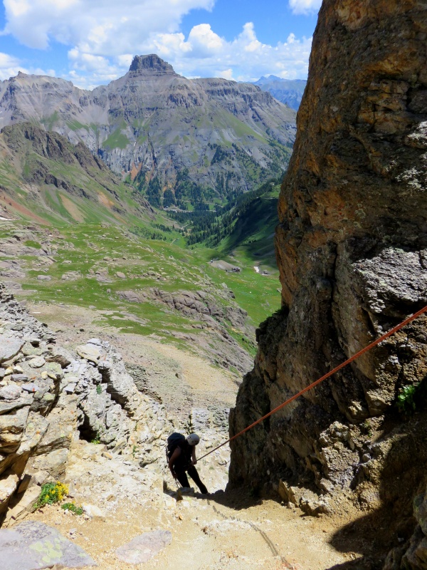
The rappel anchor needs attention, and we thread new cord through the ring before rappelling back to our staging area. Just on the north side of the summit tower, two gullies north of the ascent gully, is a squat hoodoo with sun-faded black webbing and a quicklink. We recall using this same piece of gear on our prior descent. The knot is frayed but I retie it to eliminate the damage, and we rappel 35 meters down a junky, low-angle side gully that meets the ascent chute near the bottom.
Now the sun is bearing down in force, and the missile troops are waking from their slumber. During our adventure the icy crust has morphed into slushy corn, and we speed to safety, glissading back to the truck in what seems like minutes.
Gear: Cams BD 0.5 to #4 (a #5 may also be used). Anchor material. A 70m rope is nice if rappelling the approach gullies.
Saint Sophia Ridge, 7 Aug 2016
Saint Sophia Ridge, 25 May 2020
East face detail
Starting up the chute
Kylie leads the summit tower
View to south
View to Emma
Rappelling the summit tower, summer 2016
Rappelling the east face, summer 2016
Kylie in Wildflower Heaven, summer 2016
Thumbnails for uploaded photos (click to open slideshow):
before I even read it, because I knew the report would deliver! Nice writing and I like the comparison of your summer outing of the pinnacle. Once again, thanks for sharing your adventures here! I would double like it, if I could...
Looks like fun! I did a high camp up there right above St. Sophia Ridge about 10 days ago; you might be interested to see the photos here. Really cool ridge.
@Darin, thanks for the kind words!
@Jack, nice photos and what a great spot to camp; love the possibilities a bit of snow makes.
@Abe, I was trying to remember why you all were there, haha. I think Kylie's TR would have been "nice day. easy climb. mad no flowers." Hope you're doing well, too. We've been kicking around a Boise trip--we'll be in touch.
Snow route: Via the Sneffels standard trailhead, hiking up around Stony to cross over the Stony-Emma saddle saves a small bit of gain but also affords a spring combo with Stony NF. This approach moreover highlights a way to gain the ridge that is less steep and has comparatively little overhead hazard versus the standard choss flume. Approaching or viewed from the north, there are 2 closely-spaced gullies just north of the main tower. The left/south one is the rappel gully we have used (though some rap the standard choss flume), and the broader right one is the easier/better approach gully. It's also a reasonable downclimb, so you can bring a shorter rope (30m is plenty for just the summit tower) going this way.
Caution: The information contained in this report may not be accurate and should not be the only resource used in preparation for your climb. Failure to have the necessary experience, physical conditioning, supplies or equipment can result in injury or death. 14ers.com and the author(s) of this report provide no warranties, either express or implied, that the information provided is accurate or reliable. By using the information provided, you agree to indemnify and hold harmless 14ers.com and the report author(s) with respect to any claims and demands against them, including any attorney fees and expenses. Please read the 14ers.com Safety and Disclaimer pages for more information.
Please respect private property: 14ers.com supports the rights of private landowners to determine how and by whom their land will be used. In Colorado, it is your responsibility to determine if land is private and to obtain the appropriate permission before entering the property.


")
")
")
")
")
")
")
")
")
")
")
")
")
")
")