Download Agreement, Release, and Acknowledgement of Risk:
You (the person requesting this file download) fully understand mountain climbing ("Activity") involves risks and dangers of serious bodily injury, including permanent disability, paralysis, and death ("Risks") and you fully accept and assume all such risks and all responsibility for losses, costs, and damages you incur as a result of your participation in this Activity.
You acknowledge that information in the file you have chosen to download may not be accurate and may contain errors. You agree to assume all risks when using this information and agree to release and discharge 14ers.com, 14ers Inc. and the author(s) of such information (collectively, the "Released Parties").
You hereby discharge the Released Parties from all damages, actions, claims and liabilities of any nature, specifically including, but not limited to, damages, actions, claims and liabilities arising from or related to the negligence of the Released Parties. You further agree to indemnify, hold harmless and defend 14ers.com, 14ers Inc. and each of the other Released Parties from and against any loss, damage, liability and expense, including costs and attorney fees, incurred by 14ers.com, 14ers Inc. or any of the other Released Parties as a result of you using information provided on the 14ers.com or 14ers Inc. websites.
You have read this agreement, fully understand its terms and intend it to be a complete and unconditional release of all liability to the greatest extent allowed by law and agree that if any portion of this agreement is held to be invalid the balance, notwithstanding, shall continue in full force and effect.
By clicking "OK" you agree to these terms. If you DO NOT agree, click "Cancel"...
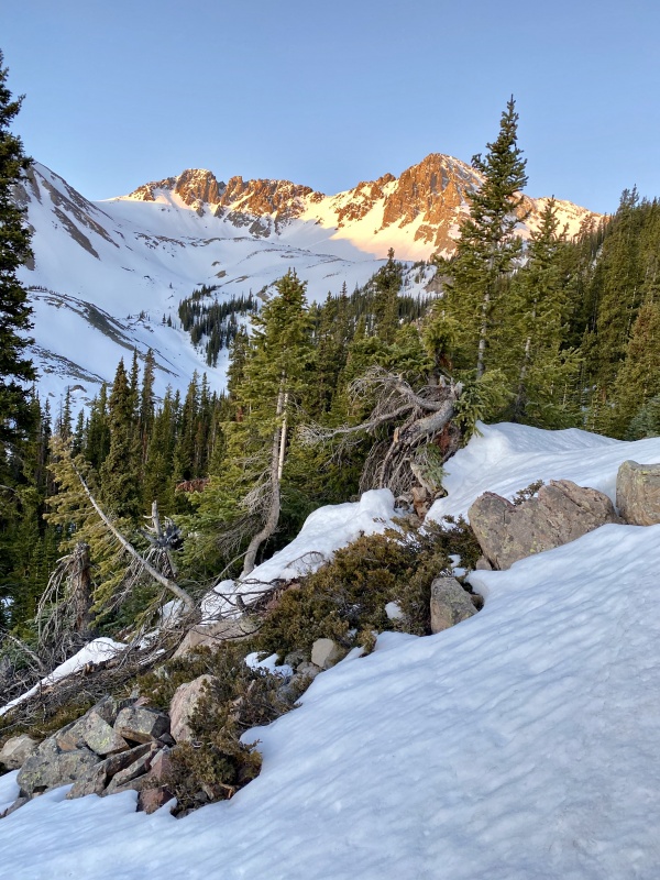
Cathedral Peak, the highest in the Elk Mountains, is a gorgeous if dangerous piece of rock. Studded with innumerable towers and built like a seven hundred layer cake (pretty but hard to eat), it nonetheless suffers from the same rotten rock as the Maroon Bells. For this reason it's best done as a snow climb, where the steepest 500 or so feet of the route can be done on snow instead of scree and dirt. I'm not even sure how one would climb the 40+ degree couloir when it's dry, as it'd just be a loose mess without anything to get purchase on. With good freezes recently Whiley and I knew it'd be a good time to get Cathedral out of the way.
We got up early and started around 5am, 30 minutes later than I wanted to start, but not showstopping. The Cathedral Lake Trail was in great shape and easy to follow, starting off dry and eventually intermixing with snow and finally becoming solid snow. Rising steeply the entire way to the lake, we were fortunate to have had a good overnight freeze and the snow on the trail was rock hard. We carefully stepped over and around the numerous icy postholes while trying to pray away our own inevitable postholing later in the day.
Two more snowshoes and one more ice tool than was necessary for our day. Note the small wet slab avalanche in the rocks to the left. Photo: Whiley H.Malemute Peak.Whiley's more artistic take on the peak in alpenglow. Photo: Whiley H.
We crossed a large, frozen wet slide and exited the trees onto a talus slope - lovely Bells mudstone - and came across probably the steepest, most compact switchbacks I've ever seen.
Switchbacks from hell.
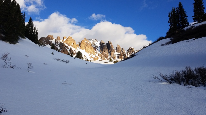
We climbed the bottom few switchbacks and stopped to put on our crampons and get out our ice axes at the top where it turned into pure snow. People had come this way but their steps had melted and frozen into small, bullet hard dishes that we couldn't climb without traction. The hard snow conditions here were great and we knew we'd have no trouble in the couloir to the ridge. The trail cut across the top of the slope from the last switchback and split, going straight ahead to Cathedral Lake or right to Electric Pass. We followed the trail towards the lake for a couple hundred yards then turned right and went over a knoll to get our first in-your-face views of Cathedral.
Cathedral Peak with the Pearl couloir dead in center. Left of the Pearl is the summit and east ridge, right is the north ridge.
The route here flattened out in the bowls below Cathedral, rolling over what must be small talus moraines which were now covered in snow, thankfully. We made good progress, crunching across the icy terrain, crossing under Cathedral's east ridge to make it to the southeast couloir.
If we had climbed the Pearl we would have gone straight ahead, but the standard route took us around to the other side of the ridge. Photo: Whiley H.Another view of Cathedral's east ridge.
When we'd gone around the east ridge's toe, really a giant blade of rock, Cathedral Lake came into view. We were far off the trail by this point.
A still-frozen Cathedral Lake.
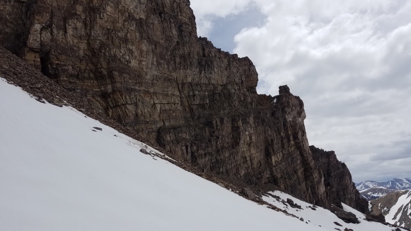
As we rounded the ridge Cathedral's east face (really the southeast face, but commonly just called the east face) came into view.
Photo: Whiley HBackside of the east ridge.I hope I'm not the first to call this tower the Bishop.Manky looking Bells rock.
We approached the face and took stock of our lines. I had wanted to climb the east face couloir, which splits the face itself and is steeper, narrower, and longer than the standard route.
The east face couloir is the narrow strip of snow farthest right that goes just below the summit.
Ultimately we decided on just doing the standard route, as neither of us had climbed much snow recently and we wanted the slightly easier variation. The east face isn't that much steeper, at about 50 degrees vs 40-45 for the standard route, but we took the latter nonetheless.
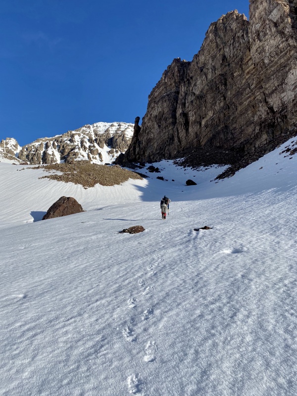
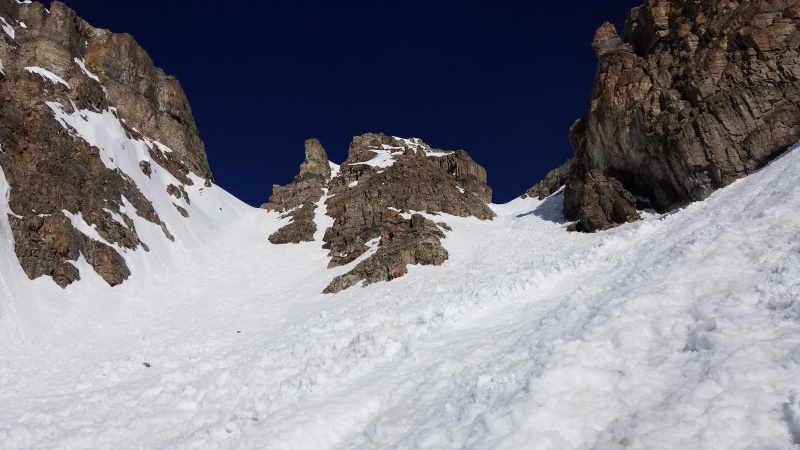
Numerous options, with the rightmost couloir being the correct one. I don't think any of the others successfully connect to the ridge, being blocked by towers.From the base of the couloir. Go up the right branch.
Our transition at the base of the couloir was quick since we already had our crampons on and axes out. We just dropped our snowshoes and ice tools on top of a knoll, since the former wouldn't be needed at least until we returned, and the couloir wasn't steep enough for the latter. We began up with me in the lead. It was just prior to 8am.
Whiley coming around the apron.
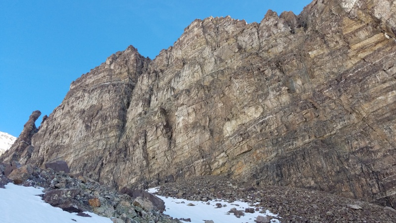
Cathedral's walls soared around us as we climbed.
The largest block on the ridge, topping the leftmost two couloirs.Looking south towards Castle (hidden behind this sub-peak).
The climbing in the couloir was a ton of fun - I thought so anyway, Whiley strongly prefers rock (she has provided a correction: not rock, but choss) to snow - and conditions could hardly have been better. There was a bit of debris to contend with but everything was frozen nicely in place and was perfect for kicking nice, forefoot steps into. A short section in the middle was smooth and a little steeper, and the very top was steeper, but overall it was very manageable.
Sprintin'. Photo: Whiley H.I love couloir photos. They always look a lot steeper than they are.
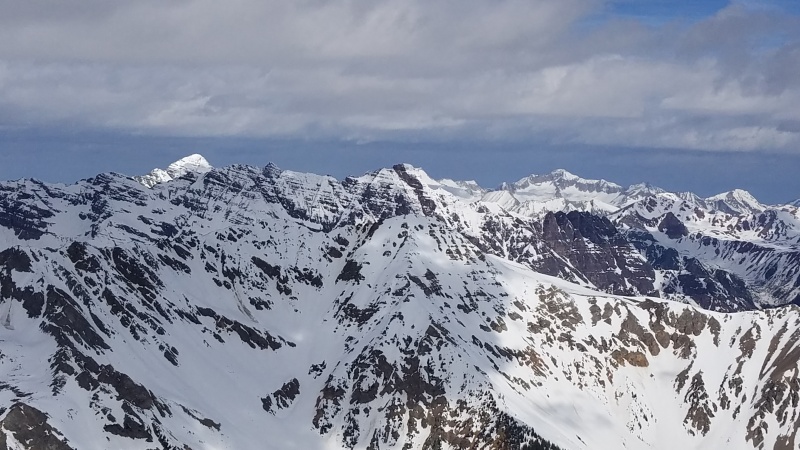
I got up to the top of the couloir at a flat saddle and was bummed the snow was over. I just wanted it to continue forever! I waited a moment for Whiley to catch up and admired the spectacular views northwest into the heart of the Elk.
Looking towards the Maroon Bells and Pyramid.A bit hard to distinguish with the photo being compressed, but Maroon Peak and North Maroon Peak are in center, Pyramid Peak is just right of center, and Capitol Peak is the brightly light peak on the right.
When Whiley topped out we regrouped and took stock of the route ahead. It looked mostly dry, so we took our crampons off and left our packs behind; axes were taken with, just in case. It was a relatively short distance and small amount of gain to the summit so we'd be up and down faster without all of the unnecessary gear. Still, we'd have to take our time on the normal Elk choss.
The start of the south ridge proper. Pretty gross.Junk, junk everywhere.
We almost immediately split up, with me traversing sidehill on loose talus and Whiley scrambling up the ridge, avoiding the larger blocks and buttresses.
I'm visible down there in the snow. Well, it was a nice talus swim, anyway. Photo: Whiley H.It's not as steep as it looks. It's as loose as it looks. Photo: Whiley H.
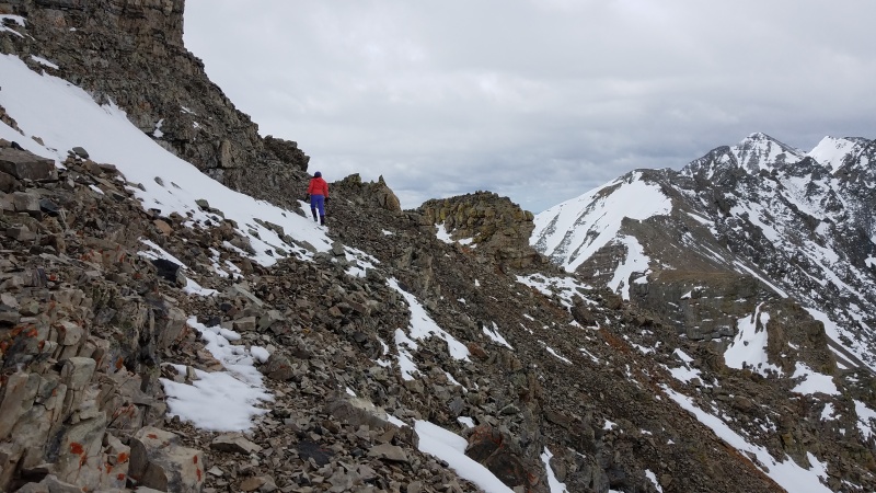
After going slow on the talus for a bit I decided I'd had enough of that and slipped and slid my way back up towards the ridge crest. Some of the larger chunks of rock blocked the very top, but they all had Class 2 to Class 2+ paths around them.
You can't go right over these towers unless you like dying (either physically, or on the inside, if you manage to get up and down). I presume you don't.Sneaking around broken junk on more broken junk.Ugly and yet somehow beautiful at the same time.
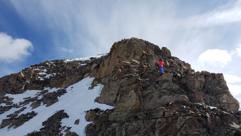
Closer to the ridge crest the Class 3 scrambling came out. The rock was loose but not as loose as the talus, and provided a more direct line up. Parts of it were fun, in spite of the rock.
Both more solid and more fun than you'd guess. Photo: Whiley H.Whiley sniffing out the weaknesses.Almost to the top.
We made abundant use of the ledges and fractures to make our way up the peak in a kind of step-like fashion. It didn't take us very long to climb the 500 feet from the col to the summit, and before we knew it there was no more to climb.
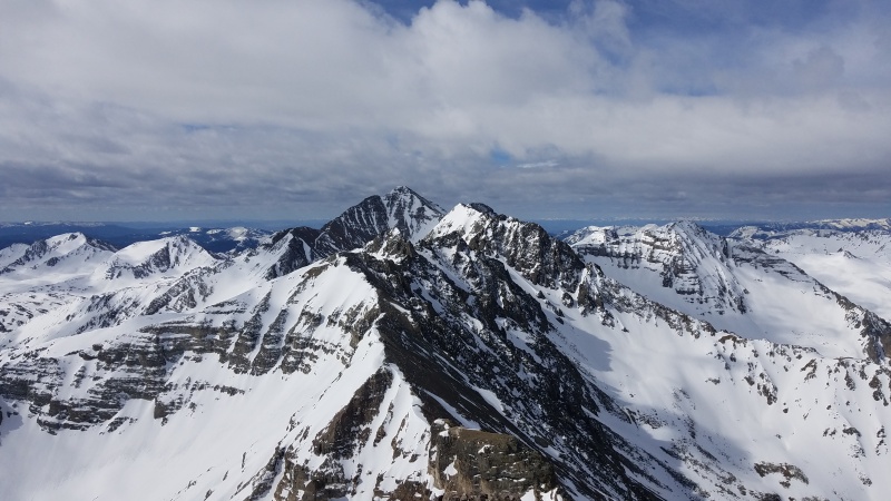
Photo: Whiley HSummit.Ridge north towards Electric Pass (and "Electric Pass Peak") and Hayden Peak.Heart of the Elk again. Maroon Peak and North Maroon on the left, Pyramid and Snowmass blending together in center, and Capitol on the right.Castle and Conundrum.
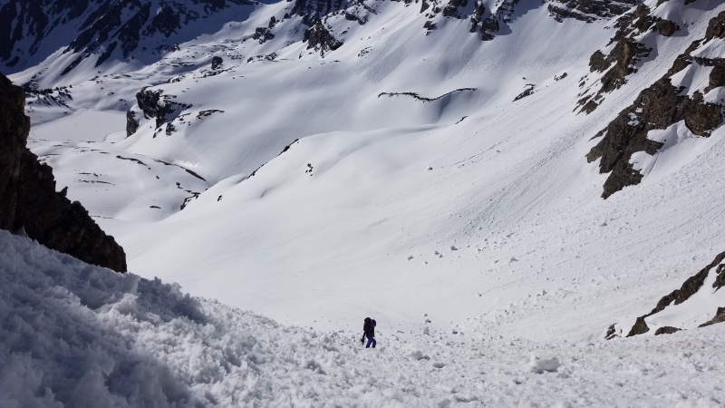
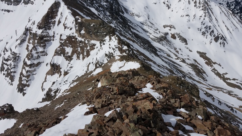
Since we were aiming to be quick in case snow conditions turned south on us we only spent a few minutes on top. Our food and water was all at the col anyway, so we sped down the ridge this time both staying high. From a higher vantage more trail segments among the crushed rock became noticeable, and we followed them as best as we could, reaching the col in about half an hour.
Looking down most of the ridge. The col is on the viewer's side of the snowy tower.It's faint, but there's a "trail" between myself and Whiley.
We strapped into our crampons and put on our packs, and I gave Whiley a short demo on facing in while down climbing snow, and we were off. Snow conditions at the top were still a bit icy, which was great, and I kept close to her as she tentatively began down climbing, kicking her own steps for comfort. As her comfort grew we moved faster and faster, until we reached the bottom third which was low enough angle to turn around and basically plunge step down. We fist bumped and had a short snack break at our snowshoe and ice tool cache, then began hiking out.
Getting close to the bottom. Our gear stash is a tiny dot just above the toe of the ridge.
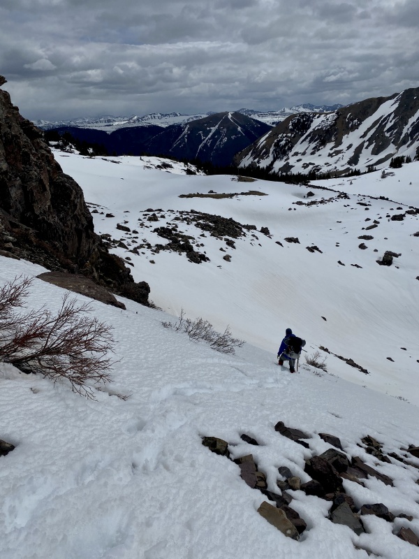
As we lost elevation the snow eventually became soft enough that we began to posthole, so we put our snowshoes on. I really didn't want to, but we had carried them up all that way, so might as well.
Icky snow.
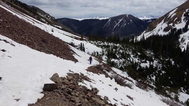
The snowshoe out went lightning fast now that we weren't wallowing, and when we reached the tight switchbacks on the lower trail we took off and packed away all of our gear and plodded down the now absurdly sloppy trail, leaving a trail of posthole destruction in our wake. We passed a couple of other hikers who were on their way to the lake and laughed when they asked if the trail improved higher up. "Nope," we said, "it just gets worse." They did not look happy, but continued on anyway.
Absolute mush.
The trail was significantly more melted out even a few hours later, but we were able to basically just plow through the soft snow, then hike quickly when the trail melted out completely. We reached the trailhead and stripped off our wet boots and clothes (it was bloody hot in the trees), stuffing our faces with food. Cathedral hadn't been quite as bad as we had expected, and our prayers for a safe climb had been answered. Climbing is my religion, the mountains my church; Cathedral may only be but one of them, and standing atop its summit one may feel closer to the heavens.
Statistics
Climbers: Ben Feinstein (myself), Whiley H. Trailhead: Cathedral Lake Total distance: 10.53 miles Total elevation gain: 5,289 feet Total time: 7:41:25 Peaks: One ranked thirteener
Cathedral Peak A, 13,943'
Splits:
Starting Location
Ending Location
Via Time (h:mm:ss)
Cumulative Time (h:mm:ss)
Rest Time (m:ss)
Cathedral Lake Trailhead
Base of Couloir
2:57:45
2:57:45
0:00
Base of Couloir
Top of Couloir
0:41:44
3:39:29
0:00
Top of Couloir
Cathedral Peak A
0:34:39
4:14:07
6:24
Cathedral Peak A
Top of Couloir
0:30:20
4:50:51
0:00
Top of Couloir
Base of Couloir
0:39:27
5:30:19
9:48
Base of Couloir
Cathedral Lake Trailhead
2:01:18
7:41:25
Trip End
My GPS Tracks on Google Maps (made from a .GPX file upload):
@TakeMeToYourSummit: I can't imagine how awful this route would be dry. Literally, I can't figure out how anyone would climb that couloir/gully without snow, it just seems too steep. I guess you could use crampons and an ice axe on the dirt but man that would suck!
Caution: The information contained in this report may not be accurate and should not be the only resource used in preparation for your climb. Failure to have the necessary experience, physical conditioning, supplies or equipment can result in injury or death. 14ers.com and the author(s) of this report provide no warranties, either express or implied, that the information provided is accurate or reliable. By using the information provided, you agree to indemnify and hold harmless 14ers.com and the report author(s) with respect to any claims and demands against them, including any attorney fees and expenses. Please read the 14ers.com Safety and Disclaimer pages for more information.
Please respect private property: 14ers.com supports the rights of private landowners to determine how and by whom their land will be used. In Colorado, it is your responsibility to determine if land is private and to obtain the appropriate permission before entering the property.


")
")
")
")
")
")
")
")
")
")
")
")
")
")
")
")
")
")
")
")
")
")
")
")
")
")
")
")
")
")
")
")
")
")
")
")
")
")
")
")
")
")


