Download Agreement, Release, and Acknowledgement of Risk:
You (the person requesting this file download) fully understand mountain climbing ("Activity") involves risks and dangers of serious bodily injury, including permanent disability, paralysis, and death ("Risks") and you fully accept and assume all such risks and all responsibility for losses, costs, and damages you incur as a result of your participation in this Activity.
You acknowledge that information in the file you have chosen to download may not be accurate and may contain errors. You agree to assume all risks when using this information and agree to release and discharge 14ers.com, 14ers Inc. and the author(s) of such information (collectively, the "Released Parties").
You hereby discharge the Released Parties from all damages, actions, claims and liabilities of any nature, specifically including, but not limited to, damages, actions, claims and liabilities arising from or related to the negligence of the Released Parties. You further agree to indemnify, hold harmless and defend 14ers.com, 14ers Inc. and each of the other Released Parties from and against any loss, damage, liability and expense, including costs and attorney fees, incurred by 14ers.com, 14ers Inc. or any of the other Released Parties as a result of you using information provided on the 14ers.com or 14ers Inc. websites.
You have read this agreement, fully understand its terms and intend it to be a complete and unconditional release of all liability to the greatest extent allowed by law and agree that if any portion of this agreement is held to be invalid the balance, notwithstanding, shall continue in full force and effect.
By clicking "OK" you agree to these terms. If you DO NOT agree, click "Cancel"...
To be honest I'm not even sure why I'm writing this report. About the only things that went well on this hike were the weather, views, and that we bagged the 4 peaks we had planned. I guess in many ways I hope this is beneficial for others looking for information on this loop and since some other trip reports don't have the gpx tracks attached I added it at the bottom. I also added other helpful tracks that we didn't have at the time like the Lindsey approach and Huerfano Trail at the end. We made a lot of mistakes in our first big outing of the year but that just adds a good reminder to always stay diligent with our planning.
Peaks Hiked:
"Huerfanito" - 13,081' (#584 in CO)
Iron Nipple - 13,500' (Unranked)
"Huerfano Peak" - 13,828' (#93 in CO)
PT 13,355 aka "Huerfana" - 13,355' (Unranked)
Hiking Statistics:
Total Length - 13.4 mi (Garmin Fenix 5/CalTopo)
Total Elevation Gain - 6,019'
Total Time (Car to Car) - 14:01:30 (Should've been around 10 hours)
Left Campsite - 6:28 AM
"Huerfanito" Summit - 11:13 AM (4:45 time; 6.00 mi) 49 min on Summit
Huerfano/Lindsey Saddle - 12:55 PM (:53 time; 1.01 mi) 45 min on Saddle
Iron Nipple Summit - 2:09 PM (:29 time; .58 mi)
"Huerfano Peak" Summit - 3:03 PM (:54 time; .83 mi) 23 min on Summit
PT 13,555 Summit - 5:30 PM (2:04 time; 1.61 mi) 50 min on Summit
Arrived Back at Campsite - 8:29 PM (2:09 time; 3.37 mi)
Trail Description:
The group (my hiking partner, his GF, her brother, and myself) arrived in the Huerfano Area the night before around 7pm and scoped out a place to set up camp. We could get all the way up the the upper 4wd TH but wanted to stay lower since we knew the end of the loop would be at the Zapata/Huerfano Trail signs. We had also planned to go for California and the neighboring 13ers from the same TH spot on Sunday. So we set up camp, cooked a really nice dinner, and tried to get some sleep before 5:30 AM wake up. My partner and I knew we had some less experienced hikers but we figured a 6:30 AM start would cover us since the weather looked good all day.
Nice fire and a small Coleman grill = Huerfano HashThe campsite
Early Morning LightThe picture everyone takes and my computer background (at least my 10/1/2016 version with the aspens)
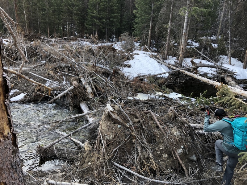
One of our first mistake was leaving the standard trail for Mount Lindsey. I added the correct gpx track below. We should've stayed on the "Class 4 Climber's Path" to the saddle. For some reason I had a track that took us off it which made us cross the creek early even though we found a crossing
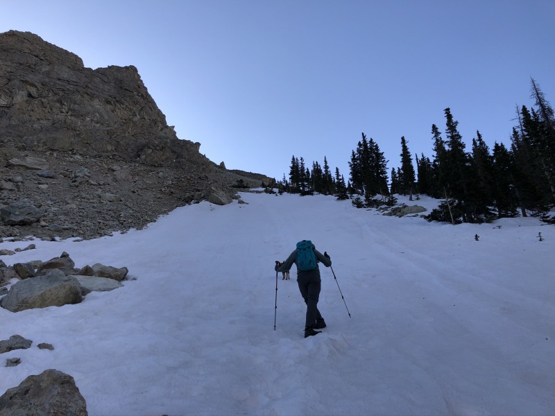
Creek crossing we usedHeading up one of the snow sections
Looking back on our route upJust can't get enough of these views
Once we get to the basin we decided to go to the Lindsey saddle and then head up the east side because some in the group didn't feel as comfortable on large snow fields so we avoided the west side of Huerfanito. The west side was the original plan (see picture below with 2 route options up west side). This turned out to be a bad call because the true summit of Huerfanito is on the west side. By starting on the east we kept getting to impassable areas and ended up having to lose elevation to get around so we split up to find a better route. My hiking partner and his GF's brother (GF decided against Huerfanito and went to Lindsey saddle) kept going higher but I had the pup (Mav) and it was windy to we kept poking around down low. I ended up finding a route but probably had wasted 20 min in time and effort. Mav and I waited on the top for the others and then heading down a much easier way. The second picture below shows the route we used after we summited and glissaded down a little ways.
Should've taken one of the two routes in red. Ended up going left off the pageRoute we used to get down from Huerfanito
After we got back to the saddle for Lindsey it was pretty straight forward direction-wise to Iron Nipple and Huerfano Peak
Heading up Iron NippleLooking back at Lindsey saddle from Iron Nipple
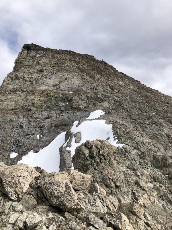
Once on top of Huerfano Peak we could see the challenge ahead to get to PT 13,555. As stated in a couple other reports staying on top of the ridge line as much as possible is best. A lot of the ridge is very enjoyable and Mav had no big issues. He just needed some help in a couple areas. Along the route there are a few points to get over so you gain 150' twice before the last 200' push to the real summit. Of course at this point in the day we were exhausted and each point felt like another 13er but we pushed ahead and waited on the summit the rest of the group to join
The ridge line to PT 13,555 which is the farthest peak on the ridgeLooking back at the last point before the summit push. You can see my hiking partner just barely in the background
Summit of PT 13,555One tired pup
A socially distanced final summit of the day
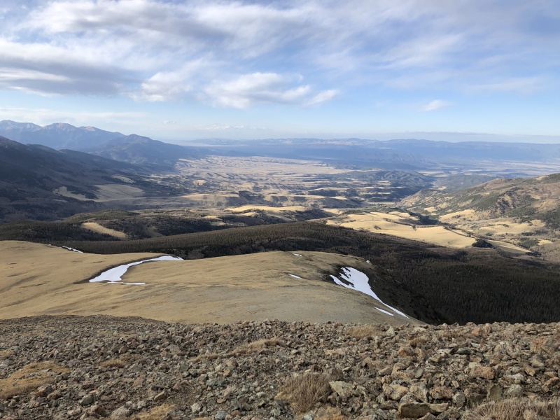
View to the north from PT 13,555Grassy stroll
So this is supposed to be the part where we say that it was a nice easy stroll down to the campsite on a nice Huerfano Trail, however, that's not the case when there is still a lot of snow past the grass in the pictures above. We had assumed that we could just meet up with the old Huerfano trail and switchback down the steep slopes, cross a wooden bridge, and roll right into the campsite. None of this happen. We foolishly didn't download the the Huerfano Trail GPX since we thought it'd be easy to find (only took 5 min of Google searching). It wasn't. We were in to twilight hours at this point and spent a good 30 min bushwhacking the trees and dodging snow trying to find the trail. No luck. It was getting darker and we knew the steep section was coming up based on map contours. We pressed on hoping to come across it but it never showed itself (hindsight we were just south of it) and soon we came to the clearing with the steep slopes. We could see our campsite but it was a good 800' below us. After trying to look around a little longer we decided to head straight down and get down fast before it was pitch black. So Mav and I started running down the steep scree and after about 10 min of that (and only falling once) came across a good stopping point. I looked around and sure enough we had stopped right on the furthest south point of a switchback. I called back to the group and we knew we were in good shape now. We ran down the rest of the nice switchback trail to the creek. Shocker. No bridge. I guess I could've paid more attention to other trip reports saying it was out. We jumped over and others walked across logs but we made it back.
Needless to say, it was a good reminder to myself that I need to stay diligent with planning, get as much beta and tracks as available, and be ready for changes in the plan by understanding different approaches. If we had done this then I think we would've saved an hour or two as a group and maybe we would've went for the California Group the next day but we decided it was best to go home and try another time when we're refreshed. The mountains aren't going anywhere.
My GPS Tracks on Google Maps (made from a .GPX file upload):
As your partner on this, I'll take half the blame for your frustrations. Do your research everyone, and know your groups fitness level before embarking on a less traveled 13er loop!
Yeah that sounds a bit rough! Some friends & I did this loop a few years ago (minus your snow). Technically I was the only one who did Huerfanito - as others in the group added 12,915 or Lindsey. I did go up the right option in your picture & glissaded down some snow between the two highpoints to the east. Even w/o snow after 13,555 its a bushwhack to reach that trail! Then we had to fetch the car at the upper TH & still make the long drives home! Awesome report - bringing me back to my time there!
did this one yesterday with a friend. Used your writeup a lot for beta, thanks.
My notes for future climbers doing this route.
We climbed the ridge NW of Huerfanito to get to the summit. Great ridge. Used your same route to get off Huerfanito and around to Iron nipple.
That ridge between Huerfano and 13,555 is no joke. Lots of sustained, tedious class 2+ and class 3 moves with some big exposure in areas. And the elevation regain on each notch was painful Took us 70 minutes to go the 1 mile. And we felt like we were hurrying.
To find the trail (Raspberry Trail?) on the north side of 13,555 for the descent, it seemed like way too long to get to it once you are in the trees. But if you hug the west side cliffs below treeline, without going down them, you'll eventually come across the trail. Its very well built, so you can't miss it. In any case, the GPX track is a good idea.
Caution: The information contained in this report may not be accurate and should not be the only resource used in preparation for your climb. Failure to have the necessary experience, physical conditioning, supplies or equipment can result in injury or death. 14ers.com and the author(s) of this report provide no warranties, either express or implied, that the information provided is accurate or reliable. By using the information provided, you agree to indemnify and hold harmless 14ers.com and the report author(s) with respect to any claims and demands against them, including any attorney fees and expenses. Please read the 14ers.com Safety and Disclaimer pages for more information.
Please respect private property: 14ers.com supports the rights of private landowners to determine how and by whom their land will be used. In Colorado, it is your responsibility to determine if land is private and to obtain the appropriate permission before entering the property.


")
")
")
")
")
")
")
")
")
")
")
")
")
")
")
")
")
")
")
")


