The indigenous Ute natives called them "breasts of the Earth". Visible in all their glory from I-25 near Walsenburg, these mammoth features are open to interpretation.

We made our trip to the Spanish Peaks with the intention of bagging both peaks in a single go. The less traveled north side of these great peaks is the key to unlocking both. Reports have also surfaced (perhaps hearsay?) that the tandem can be done from the standard Cuchara Pass TH connecting to the saddle.
Take the Highway of Legends south through La Veta. Turn off Main St and look for County Road 360. Pass two magnificent glimmering lakes before reaching the first intersection. Turn left to continue on County Road 360, then make a right to continue. The road eventually crosses Wahatoya Creek and continues a few miles on a good dirt road. It will be hard not to notice the remarkable sheer rock wall to your west as you drive in. This impressive feature is known by a few names: the "Big Wall", "Dakota Wall" and "Backbone of the Rockies". It represents one of the unique characteristics of the Spanish Peaks—the dike system.
Right after Big Wall Ranch (past the Dakota Wall) is a right turn. This marks the start of a rugged 4WD road to the Wahatoya TH. I made it about 0.75 miles up the road in a 2WD sedan before giving up and parking. There are a few pullout spots.

Even before reaching the trailhead, the hike up presented bold views.

After about 2 miles trek up the remainder of the road we reached Wahatoya Trailhead. There is a campsite here and a large area to park.

Thus begins the true hike up to the saddle between Spanish Peaks. The start points you on the north slopes of West Spanish Peak. The trail wraps around the mountain and brings you up on to the saddle. The first two miles are a gradual and consistent incline over the quietly thriving slopes.

The first mile or two of the hike begins slowly, and we made our way into the Spanish Peaks Wilderness boundary.

Until the saddle there are plenty of sections that can be crossed quickly, and definitely can be jogged on the way down. The trail narrows as the slopes get steeper, and a few washout rock fields must be crossed while gaining elevation.

The saddle is the official checkpoint of this hike. Reach the major fork between the Wahatoya Trail and the East Spanish Peak Trail. The masochistic mountaineer looking to snag West Spanish Peak can turn around at this sign, face west, and bushwhack immediately about 1,500ft up to the rocky and emotionless lower ridge of West Spanish Peak.

With a few sips of water and a stream of overconfidence, we attempted to bushwhack up to West Spanish Peak. We only made it about 500ft vertical before we made an executive decision to return to the saddle and make the better defined trip up East Spanish Peak. This will be my last warning in the trip report for those looking to capture both peaks. The bushwhack adventure is extremely difficult, and not to be underestimated.
When we returned to the saddle, we traveled about 1 mile east and directly onto the steep, sloping trail towards East Spanish Peak. The vast majority of the hike up to treeline is on this relentless serpentine trail. A few sections give way to low Class 2 rockfields, nothing to worry about.

As we worked our way up the west slope of East Spanish Peak, we gawked at the view of West Spanish Peak, it's more famous big brother.

Definitely stop to enjoy the view when reaching some of the washout boulder fields. The rocks have knocked away the trees and cleared out a magnificent view of the surrounding terrain.

As we approached treeline, the trail spread out and the trees moved like felt in front of us as we pushed through the last creeping bit of wilderness.

Immediately at treeline, we half-heartedly enjoyed the daunting view of the ridge to the summit. A massive, talus loaded line to the top of East Spanish Peak.

Hiking up a little ways, look back and enjoy the last glimpse of trees for quite some time.

The push up the ridge is consistent and straight-forward. Smaller, loose rocks can be traded for larger, more consequential ones. I preferred to jump across big rocks as the holds and footings were big. I was able to move quickly by avoiding the looser sections. While the talus bashing seems epic, the exposure is low and the view is always excellent.

Looking back from just below the summit. See how the ridge levels out and offers a fun ridge-walk as you piece together the last few hundred feet.

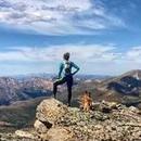
At the summit, we enjoyed the unmatched view of the Great Plains.

The impressive massif of Blanca and the rest of the Sangres dominates the view north and west. It is easy to get caught up in what surrounds you up here.

For me, I felt content admiring the immaculate view of West Spanish Peak directly across the saddle from us. Sometimes there are no words to describe what you feel.

At the summit, we enjoyed a snack and the opportunity to reach such heights in this beautiful part of Colorado.

")
")
")
")
")
")
")
")
")
")
")
")
")
")
")
")
")
")
")
")