| Report Type | Full |
| Peak(s) |
Little Bear Peak - 14,041 feet Blanca Peak - 14,350 feet |
| Date Posted | 09/26/2019 |
| Modified | 10/02/2019 |
| Date Climbed | 09/01/2019 |
| Author | OldTrad |
| LB NW Face to Blanca: Senior Ridge Curriculum 405 |
|---|
|
Little Bear NW Face to Blanca: Senior Ridge Curriculum 405 SENIOR RIDGE CURRICULUM LINKS
INTRODUCTION Report by a 60+ year old climber on another Senior Ridge Curriculum Denver “day-hike”. I.e., instead of camping, drive from Denver to the lower 2WD trailhead early AM, walk up, climb Little Bear’s NW Face, continue across the LB-to-Blanca Traverse, walk down and drive home in time for dinner 
EVOLUTION OF A TWISTED PLAN A week after climbing Gash Ridge with HB I took time off to do a normal hike with a co-worker who had flown into Denver from out of town. After his departure, I was left staring down the barrel at Labor Day weekend and I started to think about possible ways of maximizing the holiday’s hiking/climbing itinerary. Since HB had friends coming into town for the holiday, he would be unavailable and so I had to consider punishment that I could achieve on my own. At the top of my list was Little Bear’s Northwest Face, combined with the traverse to Blanca. I was also interested in Pyramid Peak and had discussed it with various friends over the past year, but still not had the opportunity to climb it either. Since Saturday was out due to a prior commitment, that left Sunday and Monday for possible “character building” days. After the rigorous ridge routes that HB and I had done over the prior weeks I felt strong and confident, although climbing solo on either of these prospective routes was not my preference. I felt I could do them, but the level of concentration required would be much higher while alone, and I’d miss the comradery of climbing with a buddy. I’ll also admit that the thought of being solo on Little Bear’s NW face and the Blanca Traverse was scary. These were very serious routes and being solo would make them more difficult than they already were. The NW Face would keep me clear of any holiday Hourglass circus, wouldn’t subject me to distasteful fixed ropes, and promised a far more technical adventure. On the other hand, if I were to try Pyramid instead, I’d be doing it on a crowded, holiday weekend which would mean that I’d likely not be alone, but would face a higher probability of rock fall, not to mention parking, traffic and other holiday challenges. The technical aspects of Pyramid were far less intimidating to me, however, and the mileage and overall effort required would be far less than what I’d face in the Sierra Blanca. Eventually I began to zero in on a plan, which would prioritize the Sierra Blanca on Sunday, leaving the possibility to go from there to Aspen in order to climb Pyramid on Labor Day. Not owning a 4WD vehicle, I thought back to a recent conversation I had with 14ers member Strayster2. He and I had rented a huge Ford F150 back in May of 2018 and used it to drive up Como road where we camped around 9,000 feet, climbing Blanca the next day. As we talked and I was raving about my distaste for the “road”, he enthusiastically mentioned that he was looking forward to his next trip up there, further wanting to do a “day hike” starting from the very bottom – the lower 2WD trailhead. After all, he and I had started this “day hike” madness in the first place, going out of our way to make already difficult hikes as hard as possible by squeezing them into single-day, single-push events, i.e., out-and-backs from Denver. 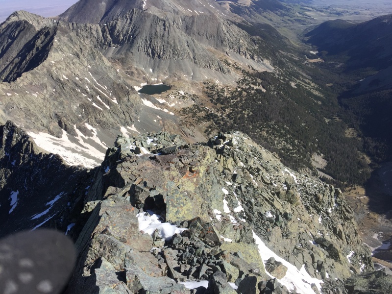
Strayster2’s brashness was impressive and infectious. However “day hikes” from Denver to the Sawatch or the Bells were one thing, but beginning and ending the day with a 3 ½ hour drive from and to Denver, with 12 miles of punishment on the Como “meat tenderizer”, all wrapped around the actual climbing, would mean turning the masochism amplifier all the way up to eleven. The idea was a completely new level of twisted beyond anything I had considered before. I worked backward from the time I felt it would take to get to the Black Hand around sunrise. If I left Denver around 11:00 pm, I ought to be able to start walking from the 2WD trailhead around 2:30 am, arriving at the initial difficulties at first light. From there a couple more hours up the face, a few hours across the traverse, and then all downhill from there back to the car! Almost a no-brainer really. The more I thought about it the more I convinced myself that I could do it. After all, Strayster2 and I had climbed the Harvard-Columbia combo this way, and on the surface the difficulty seemed similar; a 2.5 hour drive in, 6 miles of hiking at the start and 6 more at the end, with a 3 mile “difficult” section in the middle and similar vertical gain required. Despite these similarities, however, the Sierra Blanca effort promised to be slightly more difficult, requiring payment somewhere in the neighborhood of 900 RPs (Roach Points – adding an additional 100 points for the approximate increase in difficulty of LB’s NW Face over the West Ridge for the day’s 15.5 mile journey), versus the 409 extracted from us on HarvCo. Yet, who was I to nit-pick about trivial differences such as these? Though I knew Strayster2 wasn’t interested in this exact itinerary, he had not climbed Ellingwood yet so I pinged him in the off chance that he might like to join me for the death march up the meat tenderizer from the 2WD trailhead early Sunday morning. He was immediately interested, though he planned to hike again on Monday in the Crestones so we would need to take separate cars. Of course, that was not a problem because it would give me the flexibility to leave for Aspen afterwards. We could walk up together, part ways at the Blue Lakes, and then potentially meet later in the day if the timing worked out. Even with my high confidence and propensity for pain, I knew that if I wanted to pull this off, I’d need to travel as light as possible. Water would not be an issue, since water sources would be readily available. The real dilemma I faced was regarding footwear. After hiking the previous three seasons in a pair of Keens I had purchased when initially resuming hiking after my “retirement”, I realized in the midst of the previous summer’s rigor that I needed more support for the bottoms of my feet. With the Keens, I had never realized just how much hiking I would wind up doing, and during the summer of 2018, the soles of my feet got to the point where they would not completely recover between one hike’s bashing and the next. Luckily, my wife and I had put a serendipitous agreement in place for our Christmas gift exchange a few years back, where we would each buy ourselves what we wanted, then give our gifts to each another for wrapping and presentation – the result being that each of us received exactly what we wanted. My wife’s gift to me for Christmas 2018 was a pair of Salomon Quest 4D boots which fit perfectly the first time I tried them on! “How did you know????” The new boots were fantastic – comfortable and lightweight with terrific support. I had broken them in over 2019 and REALLY wanted to wear them on the meat tenderizer, but did not want to wear them during the extended technical climbing I knew would be required on LB and the traverse. On the other hand, I had worn my trusty Scarpa approach shoes during Senior Curriculum #s 401 through 404, and they performed almost as well as rock shoes on technical terrain. Furthermore, they provided midsole protection and support that was as good as any approach shoe out there. Nevertheless, even as good as my approach shoes were, I also knew that they would meet their match on the tenderizer. I wondered if there was a way to wear my Salomons on the way up, stashing them near LB and switching them out for my approach shoes, but I was worried about them being destroyed by critters. Hence, I finally made the decision to rely on the Scarpas for the entire 15-mile thrash. At least I could compensate somewhat by using my poles. The logistics were set, except for the details regarding Pyramid the following day. These logistics seemed trivial in comparison, however, and I threw some extra camping gear in my car figuring I’d decide where to sleep on Sunday evening, somewhere during the drive between the San Luis Valley and Independence Pass. On Saturday, as I was going through my final pre-launch check I was hit with another, rare moment of clarity (see also the decision not to link Lindsey with Gash Ridge). Was I off my rocker??? No, I wasn’t having second thoughts about the 900 RP “day hike”, but rather the notion that I’d somehow still be up for travelling to Aspen and up Pyramid the day after that final 6 miles on the meat tenderizer. I hastily yanked my camping gear out of the car so that I’d have no chance to reconsider, and at least slept with the small relief knowing I’d capped the potential pain I was about to subject myself to. CLIMB AND PUNISHMENT (yeah, I know – fun play on words and the cool name of a route in the Gunks) I left my house in Denver around 11:00 pm and met Strayster2 bright and early (well, dark and early actually) around 2:20 am Sunday at Como’s lower 2WD trailhead. We were walking by 2:30, anxious to begin the first half of our day’s scheduled “tenderizing”. We took our time, “enjoying” the walk up, though inexplicably got turned around in the dark at one point, losing perhaps 20 or 30 minutes in the process. It was a relief to finally arrive at Lake Como around dawn, and we continued for the next half-mile or so toward Blue Lakes where we would part ways. 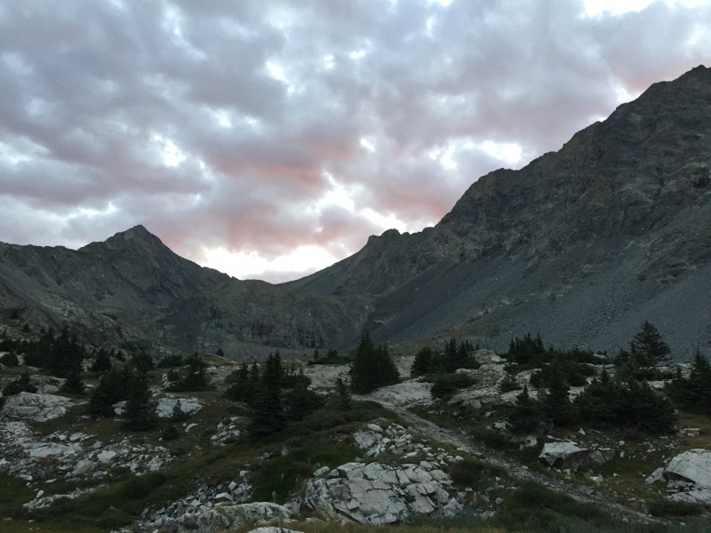
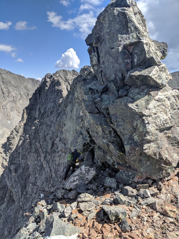
Suddenly, as we approached the lakes, we were surprised to hear voices coming from our right and noticed two climbers starting up toward the Black Hand. I was concerned about climbing below another party, hustling to catch up with them after a water re-supply and wishing Strayster2 well as he continued toward Ellingwood. Thanks to several detailed reports about Little Bear’s NW face on 14ers.com, I knew what to do on the initial section of the route. Of course, the crucial landmark is the so-called Black Hand; a hand-shaped watermark where the talus ends and the steeper NW face begins. Perhaps 200 feet to the right of the Black Hand is a second watermark near a mostly melted-out gully. The key is to start climbing up the rock face to the right of the Hand, trending up and right, until reaching a position on a rock rib where the second watermark and snow become visible. From there it is possible to reverse direction and trend up and left on fourth (?) class rock, continuing that trajectory until reaching the primary ascent gully. As I reached the point where I could see the second watermark, I was surprised to come across one of the climbers I had seen from below. He was sitting on a ledge facing outward, and appeared to be having second thoughts about continuing the climb. His partner was somewhere up to the left, and they were yelling back and forth trying to figure out what to do. It seemed his partner had done some moves that he didn’t want to reverse, and was trying to figure out whether there were any alternate descent options for a retreat. I explained to the first guy that I thought I knew where the route went, that his partner was on-route, and that I didn’t believe there was any easy way for his partner to descend without reversing back to the ledge where we were talking. He seemed to shrug this information off so I headed up and left across some steep, exposed moves (maybe fourth or fifth class) where I caught up to the second guy who proceeded to describe how tough the fourth class terrain had been and how he didn’t think he could reverse those moves back to his partner. At this point I started wondering what they were doing up there in the first place. Neither of them was wearing a helmet, they seemed confused about where the route went, and despite my insistence that I didn’t believe there was an easy route directly down to the Black Hand, the second guy began to climb straight down anyway in order to see for himself. Wishing them the best I continued up and left toward the main gully so was surprised when, perhaps 10 minutes later, I noticed climber #2 following a couple hundred feet down below and to my right. I took note and began paying closer attention, concentrating more on avoiding anything loose that I might dislodge and send in his direction. It turned out that the upward-left section on the way to the main gully went on for much longer than I expected, and I began to wonder whether I had erred in my route finding. Then, at that very moment, I happened to recall HB’s trip report where he described this very section, and mentioned seeing the only cairn on the route up on a rib and perfectly placed to mark the gully’s entrance. Lo and behold, I looked up and to the left and there was the cairn, and silently thanked HB for including that detail in his report. Once starting up the gully, I tended to stay toward its right side, preferring the better but more technical rock it offered, and felt it provided a more direct path to the saddle I could now see, immediately left of Little Bear’s summit ridge – my target at the top of the NW Face. 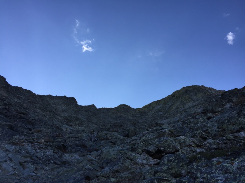

It was around this point that Climber #2 caught up to me and we finally introduced ourselves properly. His name was Matt, and he had decided to see the route through while his partner, who it turns out was actually relatively skilled on difficult terrain, had elected to turn around and return to camp for some R&R. Matt explained that he had left his helmet at their camp because he didn’t want his partner to feel psyched out since he had not brought his own. He also said that he wasn’t worried about his partner’s ability to retreat as he was an experienced hiker/climber in his own right. Matt was obviously a strong climber too, and had made up quite a bit of ground since I’d left him earlier. We climbed more or less together the rest of the way up the Northwest Face, though he preferred the central gully as opposed to the more technical terrain I naturally gravitated to, so there was plenty of distance between us in case either of us dislodged any rocks. As we continued up, perhaps midway up the face, I was surprised to find that my upper body was getting more of a workout than I expected. The climbing certainly didn’t involve my arms much, at least not in the traditional fifth class sense, however there was lots of pushing off of holds with my palms in order to stabilize while stepping up, along with ensuring my hands were always on something solid in case of a slip. Certainly, my forearms weren’t being taxed, but the combined climbing and altitude gain were making me work hard all the same. Somewhere, perhaps a hundred yards below the ridge, we heard voices and saw another party above us starting the traverse. They had presumably come up via the hourglass and were now on their way across toward Blanca. We would not see them again the rest of the day. Though overall, the NW Face did not feel technically very difficult it was quite steep, and I agree with others who have described it as fourth or fifth class. It’s dangerously exposed immediately from the start and remains so all the way to the ridge. Furthermore, it would be very easy to get off route once on the face, since it was difficult to tell exactly where you were as soon as you started to head up and left, and for the remainder of the route. On the other hand, once you reach the main gully, the target saddle becomes visible, and there appear to be many alternate ways of reaching the ridge. I must add, however, that an interesting gauge of difficulty is going back to see how many pictures you took during a given section of a climb, and it turned out I didn’t have many from the NW Face. The climbing was certainly steep and difficult enough that I wasn’t thinking about much beyond remaining safe while on the face, so take that as you will. Finally, we arrived at target saddle as planned, and turned right, onto and up the summit ridge. When we arrived at Little Bear’s summit, there were three other people already there. It appeared that they might be two paying clients and a guide – one of them was obviously the leader while the other two could not identify the route they had taken when I asked if they had climbed the hourglass. They had replied that they had not, so I assumed that they had climbed the Southwest Ridge (cool!). However, when the conversation shifted to fixed ropes they said that yes, they had come up that way after all. Their lack of knowledge about their route reinforced my guide/client theory somewhat, but to each their own. 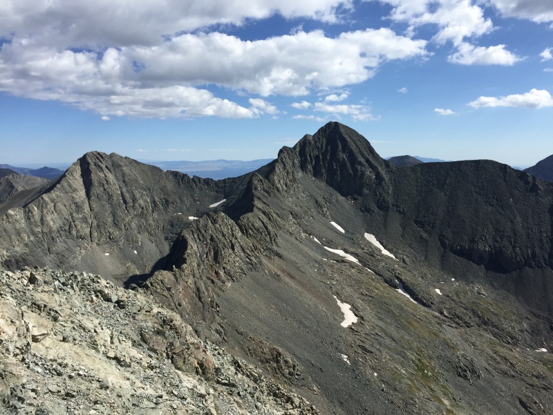
The leader then asked us if we had come across the traverse from Blanca and we said no and that we had come up the Northwest Face. Perhaps unaware that there was such a route, the leader seemed a bit taken aback by that. While introducing ourselves I mentioned that I had driven up from Denver that morning and then proceeded to take off my helmet, revealing my grey and balding pate. I then asked Matt if he wanted to join me on the traverse and he said he did. At that point, I sensed the social dynamic change slightly as the leader suddenly began a line of query, apparently gauging the interest of the other two in doing the same. Although I didn’t hear all of and don’t remember the exact exchange, the leader started to delicately say things like “You really shouldn’t do this if you don’t feel comfortable… I don’t want to talk you into anything… It’s a really cool route and even though it’s exposed I think you could probably do it…” – the kinds of things we might say when WE want to do something tough, but know it will be a leap for our partner(s), and are hoping that our partner(s) will somehow come up with the gumption to say “Hell yeah, – let’s go!” Given the circumstances, I couldn’t help but wonder if my age was contributing to the leader’s sudden motivation to continue across, but at that point I certainly did not expect the two “clients” to go along with what looked to be a sudden proposed change in plans. On this last point it turns out that I was at least partly mistaken – more on that later. After our relaxing summit break, Matt and I exited down the NE ridge to start the traverse. It was great to be able to team up with him, as he had seemed competent ever since joining me on the NW Face. He told me that he had started climbing in the Cascades, had since moved to Colorado, and had done a fair amount of technical climbing with his brother, including at altitude in RMNP. Additionally he seemed ok with the constant exposure, so I was confident we would both be safe on the traverse and was happy not having to “go it alone” (although I’m equally confident that I could have done so as originally intended). Plus, Matt was good guy, a solid, grind-it-out climber, and very pleasant to be around. 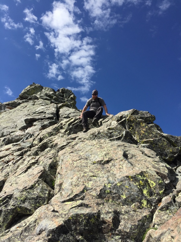
Matt was fine with me taking the lead as we started across the ridge. I was determined to take my time and had shifted into my “this is exposed”, “find the most secure route”, and “don’t make any mistakes” mindset and had decided beforehand that I’d do everything in my power not to trust anything without testing it first, etc… I was determined to get off in one piece, and my moderate pace ended up being a perfect speed for us both. 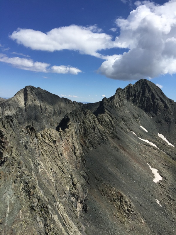
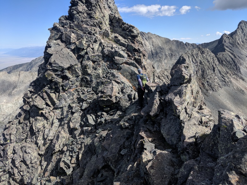
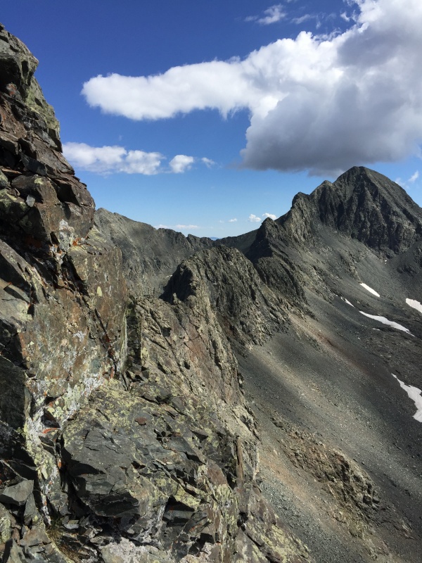
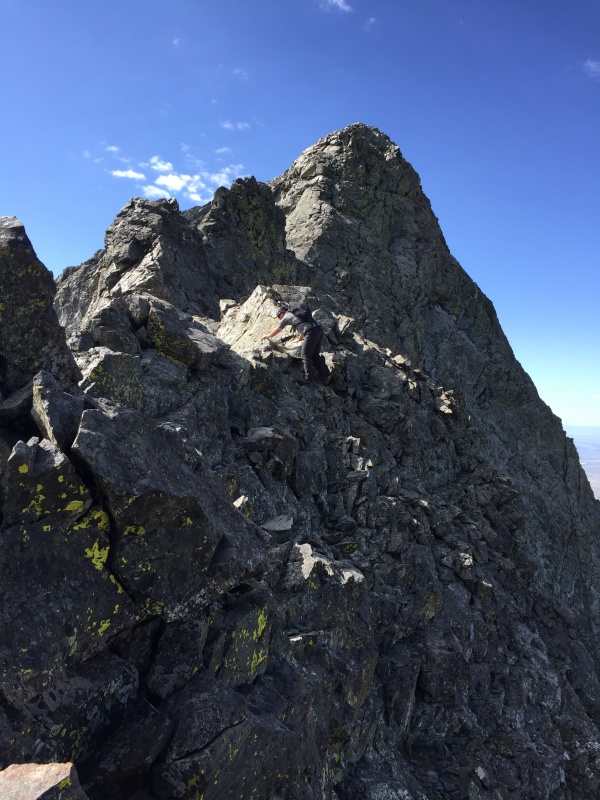
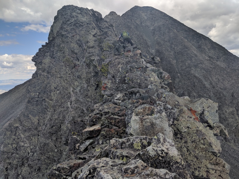
As we approached Captain Bivwacko tower we noticed that the other summit party had started across the traverse! We could hear them and saw that they were already down the summit ridge and navigating the big bump to the northeast of the initial saddle. I was surprised that they had elected to try it at all – their leader must have been very persuasive – but mostly I was concerned for the two climbers who I felt were probably talked into doing something they weren’t really prepared to do. The scrambling along the ridge is a blast, but as everyone who climbs it says, one has to maintain extreme concentration throughout – nearly everything is “no-fall” territory. There is all kinds of climbing to be had and it’s all great fun, though almost always exposed and sometimes outrageously so! There are knife-edge sections where you hand-traverse along one side or the other, there are pinnacles you climb over and around, there are “obvious” sections where you end up being tricked into heading into dead-ends, and the climbing just keeps going on and on and on. One my favorite parts about being able to lead Matt across, was how often I’d walk up to an apparent drop-off, only to look over and discover a surprise path heading down, rarely apparent until I looked right over the edge. Regarding the overall rock quality, most of the rock is solid, but in typical Rocky Mountains fashion, there’s always loose stuff everywhere. IMO, nobody should attempt this unless they understand that everything should be assumed “suspect” (i.e., loose), and can take appropriate care to ensure that they don’t make the mistake of grabbing or stepping on anything that would result in a fall. I mean, that is just Climbing Safety 101, amiright? WARNING: GEEZER OPINION/SOAPBOX! Sooooooooo, just as I’m horrified by peoples’ trust in the hourglass fixed ropes, I’m equally shocked by how many folks appear to assume that everything along the traverse is solid. For instance, a day or two later, a friend pointed me to a youtube video of Virtual Sherpa (who I’d like to think would know better) on the LB-Blanca traverse showing someone (VS himself?) seemingly grabbing and pulling on everything in sight – apparently not making any effort to test anything prior to pulling on whatever came into reach! I also recall a 14ers trip report on the traverse where the author, a seemingly skilled climber, expressed surprise when encountering something loose along the Catwalk. I mean, ARE YOU KIDDING ME? Call me conservative and old-fashioned. Again. So with that out of my system, I’ll resume by saying we passed Bivwacko via the 5.2 traverse to the north (not the crawl), and eventually reached the highway. Somewhere around there, we noticed that the other summit party was no longer behind us, presumably having retreated off the traverse and back up Little Bear to the West Ridge. This was a relief to me, as I really didn’t get the feeling that all three climbers were aligned enough to tackle it, and I’m guessing the exposure along the first pinnacle was enough to get them to change their minds. Hats off to their team for turning around and saving this beautiful ridge for another day! 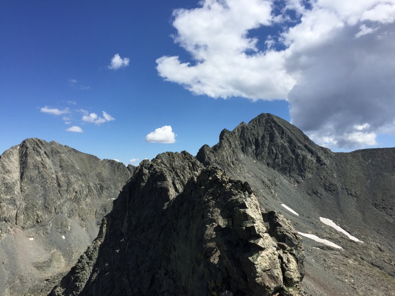
Beyond that, the climbing eases off in difficulty for a while, and we eventually got to the saddle. After traversing around the first tower, we climbed what I felt was the physical crux of the entire traverse, a seemingly endless section of steep climbing which finally brings you to the top of the second tower after what feels like an eternity of unrelenting elevation gain. The Catwalk is unforgettable too; a lengthy section, at least several hundred feet, of impossibly narrow ridge, which climbs steeply in its own right. Being quite fatigued by the time we arrived there, I was definitely not comfortable walking along that part of the ridge, and instead felt better scooting along on my butt and then sometimes swinging my feet off the side, enabling me to hand-traverse along the top. 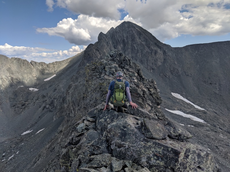
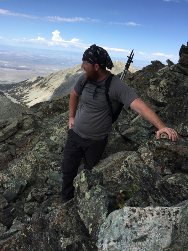
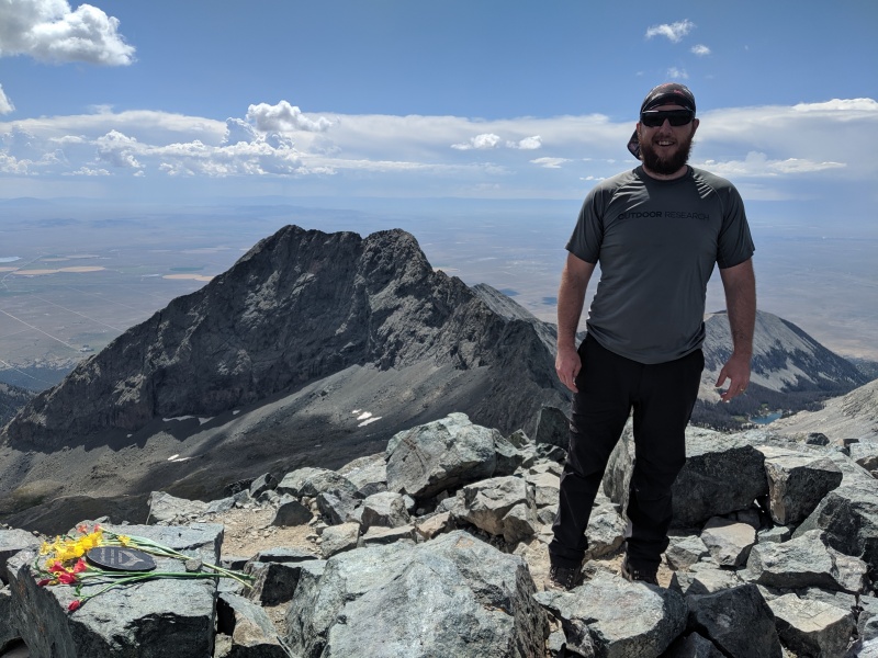

Ultimately and thankfully, we did finally arrive at the top of Blanca, and were all alone when we got there. We immediately noticed some spray-painted graffiti on one of bigger summit blocks, which made me sad, but were exhausted and relieved to have the relentless exposure behind us at last. After the requisite summit victory pictures we headed down the ridge where we met a couple on their way up, who out of nowhere stopped and asked me who I was, and then proceeded to deliver me a greeting from Strayster2! Apparently, they had met and chatted prior to heading up from their campsite, and I was thrilled to receive his greeting from these unlikely foot messengers! 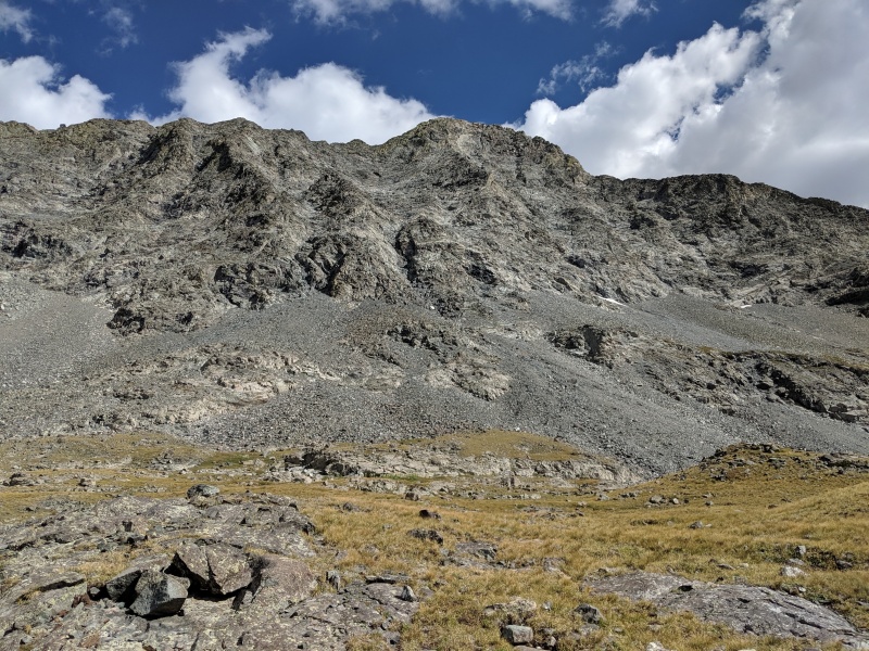
Once we got back to Lake Como Matt said goodbye and headed back to his campsite, his group planned to make the trip down the next day - Labor Day Monday. From there I figured I had missed Strayster2 and so I was left to my own devices on the meat tenderizer. After all, I wasn’t finished with my “day hike”, and therefore still had more “enjoyment”, “memorable walking”, “character building” and "treatment" ahead before all 900 RPs of dues had been paid in full. That “fun” walk down took forever, give or take, and I was ever-so-relieved to reach my car around 7:30 pm, roughly 17 hours from when Strayster2 and I had started on up. From there I drove home, massaging wicked cramps in my legs while I did, and arriving around 11:00 pm -- just in time for a post “day hike” dinner! Thumbnails for uploaded photos (click to open slideshow): ")
")
")
")
")
")
")
")
")
")
")
")
")
")
")
")
")
")
")
")
|
| Comments or Questions | ||||||||||||
|---|---|---|---|---|---|---|---|---|---|---|---|---|
|
Caution: The information contained in this report may not be accurate and should not be the only resource used in preparation for your climb. Failure to have the necessary experience, physical conditioning, supplies or equipment can result in injury or death. 14ers.com and the author(s) of this report provide no warranties, either express or implied, that the information provided is accurate or reliable. By using the information provided, you agree to indemnify and hold harmless 14ers.com and the report author(s) with respect to any claims and demands against them, including any attorney fees and expenses. Please read the 14ers.com Safety and Disclaimer pages for more information.
Please respect private property: 14ers.com supports the rights of private landowners to determine how and by whom their land will be used. In Colorado, it is your responsibility to determine if land is private and to obtain the appropriate permission before entering the property.