I read a LOT of Capitol trip reports over the years - some for route finding, some for risk analysis, some for time estimates...this one will be pretty photo-heavy, but hopefully you still find it useful if you're thinking about hiking the Big C, and good reminiscing if you already have.
Capitol was a big decision for us (as I'm sure it is for nearly anyone around here). We have focused almost entirely on class 3-4 scrambles in CO and elsewhere for the last couple years, but the Capitol’s reputation still gave us pause. We were glad to climb with Sean (stee), who has shared great adventures on the Crestones and Lone Eagle Peak. We were back and forth on what peak to tackle, but when Capitol's forecast continued to develop into a perfect day it seemed like the right choice. We opted to backpack to the lake and spend night.
TH to Capitol Lake Campsites
6.8mi, 2409 ft (per gaia, included checking out campsites), 3hrs 30 min

Just steps from the TH
The hike to Capitol Lake was one of our favorite approach hikes overall (probably tied with the hike into Crater/Mirror lake for Lone Eagle Peak), and we hit it perfectly for peak wildflowers.We stayed on the Ditch Trail until it joined with Capitol Creek and figured out a decent crossing given the relatively high water level. The elevation gain was nice and gradual with only a few real climbs and great scenery the whole time - you can see Capitol from the moment you step out of the car.

A large aspen grove early in the hike. This must be incredible in the fall.


Seriously, does it get any better than this?
We had a pretty unique experience when we saw a black bear munching on some grass about 3/4 down the trail. He was probably 100 feet off the trail, and seemed happy to sit and eat, so we enjoyed the experience and continued on our way.

Hey buddy

Flowers


Stream Crossings

More Flowers

And more flowers
Once we reached the campsites, we checked out sites 5-8 (they seemed closer), but they were full of climbers from the day before. We went back to 1-4. They may be slightly further away, but I think they are actually a better choice, as 5-8 have an annoying hill to climb. We went to dip our feet in the water at Capitol Lake, have dinner by the water, and scope out the ridge we'd be climbing the next day. We watched a dozen or so deer prance around some small snowfields during the sunset alpenglow, then turned in for the night.


Our evening entertainment

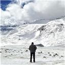
The ridge...It almost looks inviting with alpenglow
Capitol Lake to Summit
4:40 mi RT, 2280ft (5 hrs to summit, 3:20 descent to campsites)

We had discussed our departure time for a while, and landed on a 3am wakeup, and would depart whenever we were ready. We left the campsites around 3:45, and after a stop by the lake were on the trail up to the saddle w Mt. Daly. That initial hill was quite a wakeup, but was over soon enough, with just enough moonlight for views through the other side once we reached the top.
We began the traverse around the east side, which included crossing a number of snow-filled gullies. We had debated bringing along microspikes, but were very glad we had them - the pre-dawn snow was very firm and hard packed, and a couple of the snowfields would have been dicy. The scrambling began here and there, as well as some Elk loose boulders.


Even here, these refrigerator sized blocks would sometimes thunder as they rocked under our weight
Eventually, just as the sky began to brighten, we reached a final steep snowfield. We reached the hard right hand turn under K2 (around 12,700) around sunrise, with beautiful alpenglow and neon purple clouds.

The last snowfield - it was steep!

Some crazy clouds during sunrise


Around this time, my wife began to have some nausea struggles from what we assume was altitude issues. It was a rough day for her, as from here on out she wasn't able to keep anything down. She really gritted through to finish a difficult day with almost no calories and feeling low the whole time - what a champ! I definitely would have called it early.

My incredible wife, fighting through altitude sickness.
We got near the base of K2 (with views opening up to the rest of the Elks), with one of the few decisions for the climb: over the top of K2 on solid, but more difficult rock, or traverse around to the right on easier loose rock. We decided to give a shot going up and over and deal with the class 4 downclimb. I'm not 100% positive we were on route descending off of K2, but it felt like solid, stiff class 4 downclimb...never particularly exposed to the whole mountainside like the knife edge, but certainly several moves to pay close attention to.

Ascending K2

Moving down the ~Class 4 backside of K2

Beginning the NE ridge proper after K2
Once off K2, we were very quickly getting close to the knife edge. We had different feelings about it in our party of three, depending on the our current feelings about exposure, health levels, and general feelings about the route. Personally, while I didn’t felt any "heeby jeebies" on the knife edge and really enjoyed it (excellent rock, lots of holds, great exposure, and an incredible position), I was thankful for good conditions – ice/wind/rain would make this a different animal! As others have said, I think the section would be basic class 2 or easy class 3 if not for the exposure. There are a couple points where the position changes are somewhat awkward, from butt-scootch, to higher butt-scootch, to traverse, to other side traverse. These transitions take a little forethought about balance and holds.


After crossing the knife edge and the following "butter knife" ridges, we began the ascent of the summit tower. Up until this point I felt like we had made pretty good moving time, but things slow down here – the route steepens, route finding takes attention, and every step needs to be tested while keeping solid 3 points of contact. The combined conditions lead to a need to remain fully focused - look for the route, evaluate the rock, test its stability, consider your personal balance if something shifts. Repeat, while moving, a thousand times...then ramp up the focus level for the descent. For me, it was impressive that so much rock was (at least temporarily) stable, when EVERYTHING looked like it was disconnected and ready to slide down the big hill.

This is just after the knife edge.

All the scrambled blocks to work through


A steeper section nearing the summit ridge

The views don't suck!
Eventually, we finished the long ascending traverse, wrapped around the back, and climbed up to the summit ridge. The fun returned once on the summit ridge, with some great scrambling until the actual summit itself.


The summit itself is small-ish, with incredible views into the barren Pierre Lakes basin on one side, and the lush Capitol Lake basin on the other. We hadn't seen anyone else on the mountain at that point (and didn't until well into the descent), so lounged on the the summit alone for awhile. It was a nice respite from the moderate intensity of the ascent and upcoming descent.

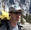
Summit Crew!
The descent took a lot of time, effort, and focus. At some point we got only 20 feet off route, and had some nerveracking, loose downclimbing to get back on track. Otherwise, it was relatively uneventful until we got back to K2, save for the dozen scrapes on my ankles and calves from rocks flipping into my legs. Since we had gone over the top of K2 for the class 4 variation on the ascent, we opted to try the class three traverse around K2 for the descent. It was pretty crappy - I'd opt for the class 4 up-and-over option.

Practice those dips...

Sean giving some beta on the descent

Hopefully this gives some sense of scale


Back on the knife edge
After a sloshy descent through the snowfields, we finally made it to the Mt. Daly saddle, and eventually down the hill to Capitol Lake. After a quick foot soak and pack up, it was time to cruise the 6 miles back to the trailhead. A few miles, cows, and flowers later we were back at the car.

Overall, I think Capitol had a different feel for each of us. Capitol’s reputation seems well earned - it’s not a death trap, but there is considerable time with very consequential scrambling and hiking. For me, everything through the end of the knife edge was awesome. After the knife edge, there was a lot of mental energy to stay focused on all those loose blocks in an extended no fall zone. I’m glad that we had such a gorgeous overall experience - the approach, wildflowers, Capitol Lake, Pierre Lakes Basin - to accompany the day. The Elks will impress in any conditions, and we were fortunate with a perfect day.
")
")
")
")
")
")
")
")
")
")
")
")
")
")
")
")
")
")
")
")
")
")
")
")
")
")
")
")
")
")
")
")
")
")
")
")
")
")
")
")
")
")
")
")
")
")
")
")
")
")