Download Agreement, Release, and Acknowledgement of Risk:
You (the person requesting this file download) fully understand mountain climbing ("Activity") involves risks and dangers of serious bodily injury, including permanent disability, paralysis, and death ("Risks") and you fully accept and assume all such risks and all responsibility for losses, costs, and damages you incur as a result of your participation in this Activity.
You acknowledge that information in the file you have chosen to download may not be accurate and may contain errors. You agree to assume all risks when using this information and agree to release and discharge 14ers.com, 14ers Inc. and the author(s) of such information (collectively, the "Released Parties").
You hereby discharge the Released Parties from all damages, actions, claims and liabilities of any nature, specifically including, but not limited to, damages, actions, claims and liabilities arising from or related to the negligence of the Released Parties. You further agree to indemnify, hold harmless and defend 14ers.com, 14ers Inc. and each of the other Released Parties from and against any loss, damage, liability and expense, including costs and attorney fees, incurred by 14ers.com, 14ers Inc. or any of the other Released Parties as a result of you using information provided on the 14ers.com or 14ers Inc. websites.
You have read this agreement, fully understand its terms and intend it to be a complete and unconditional release of all liability to the greatest extent allowed by law and agree that if any portion of this agreement is held to be invalid the balance, notwithstanding, shall continue in full force and effect.
By clicking "OK" you agree to these terms. If you DO NOT agree, click "Cancel"...
Mountain(s): Rio Grande Pyramid (13,821') Route: East Slopes/Opal Lake Trail from Rio Grande Reservoir Date: September 2-4, 2019 RT Distance: 20.2 miles RT Gain: 4,410' RT Time: 10.5 hours (moving + stopped time, not counting camps) Climbers: Solo + Zia the Dog
I haven't authored a trip report in so long that this "new" editor is a total novelty. Nice job, Bill. You TR-writing whippersnappers have it so easy these days...
After racing through the 14ers as fast as I could in about 2.5 years, I became burned out on lists. The Centennials have never called to me simply because I enjoy doing what I want, when I want to do it, and sometimes that's paddling a lake or backpacking in the desert instead of feeling obligated to attempt a new peak whenever I drive westbound out of Denver. Obsessions can quickly become suffocating; toward the end, several 14ers certainly felt like something I "had" to do instead of something I truly enjoyed in that particular moment. I vowed never to let that happen again. Still, the Centennials are there, and I've ticked off a handful every year since wrapping up my first 14er lap in 2012. I do plan to finish them eventually. There's just no rush.
Rio Grande Pyramid is one of the Highest 100 that has actually always serenaded me with its siren song. Something about the trip reports I read, the views of the almost-perfect triangle from elsewhere in the San Juans, or simply the name itself made me regard RGP as an absolutely classic, must-do peak. Having now summited, I can confidently say that the alluring mystique of the eastern Weminuche's most famous mountain is mostly a facade. To steal from and paraphrase one of the best passages from Jon Krakauer's Eiger Dreams, the most enjoyable part of climbing Rio Grande Pyramid is having climbed Rio Grande Pyramid and being done with it.
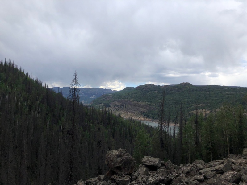
Don't get me wrong. The setting is spectacular. The eastern Weminuche Wilderness has more piles of horse shit than people (by a wide margin), and the views of Weminuche Pass and The Window make it one of the most scenic mountain routes in Colorado. It's a stunning hike until about 11,500', at which point you should be prepared to spend the next several hours either hopping deadfall, losing trails, wrestling willows, slipping backward in ankle-deep scree, or "scrambling" on loose talus that's about as trustworthy as the Denver Broncos' offensive line. The approach is an A+. The actual climbing sections are a D-. Luckily, the payoff is worth the misery -- the summit view takes that A+ approach, throws in some extra credit, gets published in a trade journal, and ends up with a final grade somewhere in the 120-130 range with a whole lot of gold-star stickers.
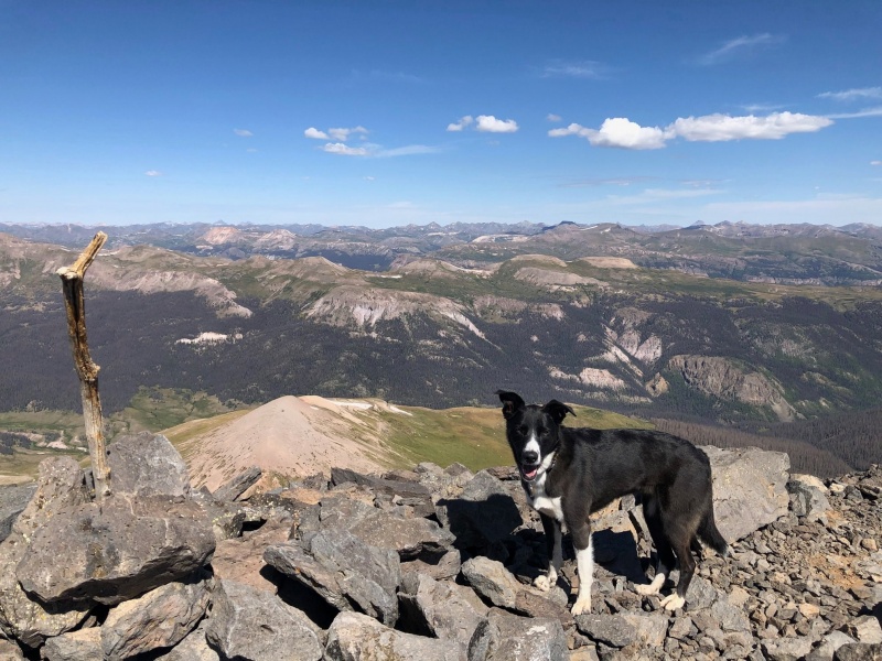
Rio Grande Pyramid summit views.
I first attempted Rio Grande Pyramid in the summer of 2017. I blew right past the turnoff for the Opal Lake Trail at Weminuche Pass, ended up on the Continental Divide Trail, and camped below The Window. I tried in vain to find a way up RGP from that location -- which is very possible and commonly done -- but gave up after an hour or so of willow bashing and accepted a summit of 13er "The Window Peak" as a consolation prize. The Window blew my mind when I encountered a photo of it in one of my very first Colorado hiking guidebooks, and I'd yet to actually have close-up eyes on it. I left that 2017 attempt not with feelings of failure, but fulfilled from an amazing weekend wandering above treeline surrounded by features that had captivated my imagination for nearly a decade.
Still, the mountain begged to be climbed. I decided to return this September after my partner for a planned thru-hike of the entire Weminuche Wilderness from Endlich Mesa to Highland Mary Lakes bailed last-minute (COUGHDILLONCOUGH). Solo on a post-Labor Day weekday ended up being a fantastic choice. I had the mountain and surrounding trails largely to myself, and this time my prior experience aided with navigation.
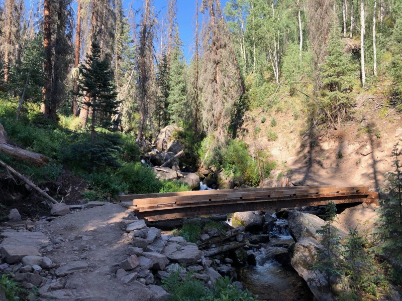
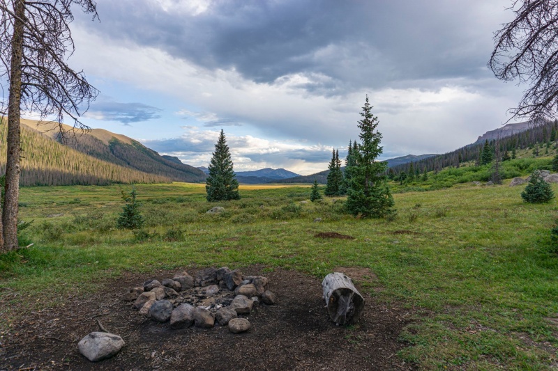
I left Denver at a leisurely pace the morning of Monday, Sept. 2, arriving at the Rio Grande Reservoir trailhead in the mid-afternoon. I started my hike up the Weminuche Creek Trail sometime around 3:30 p.m. in unsettled weather. The path climbs gently yet steadily as it parallels the southeast section of the reservoir before cutting hard left. It's the perfect grade for quickly eating up miles and elevation. Shortly after turning away from the reservoir, you'll climb to a well-maintained wooden bridge. The trail remains steep after the crossing, but once you crest about 10,000' it mellows out considerably and remains flat to Weminuche Pass. I covered the 5 miles to the pass in about 1 hour and 45 minutes and set up camp. There are several fire rings in the area, but in my opinion the legions of beetle-kill trees make most of them dangerous. The best site, by far, is in the last stand of (mostly healthy) trees on the southern edge of the pass. It was also the only site that wasn't completely overrun with fresh horse crap. Seriously, I get horse poop is biodegradable and fine for the environment and all that, but some of these trails are more shit than dirt at this point.
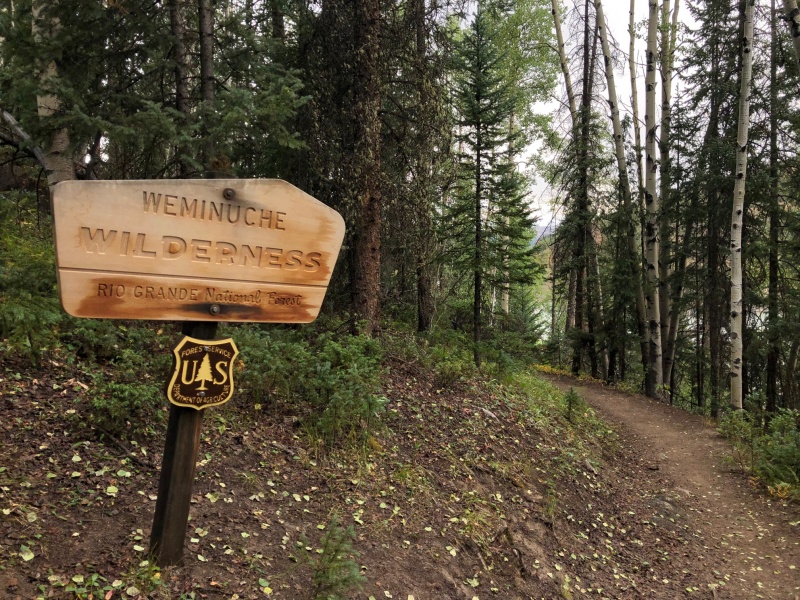
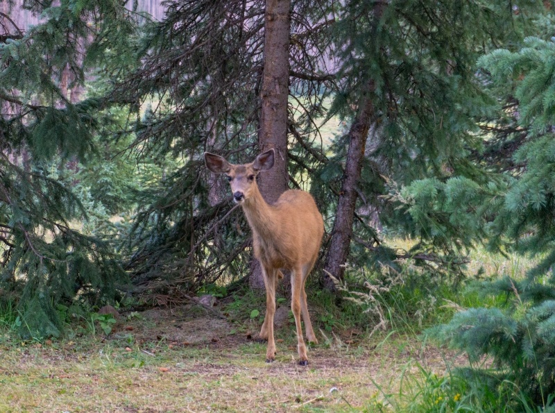
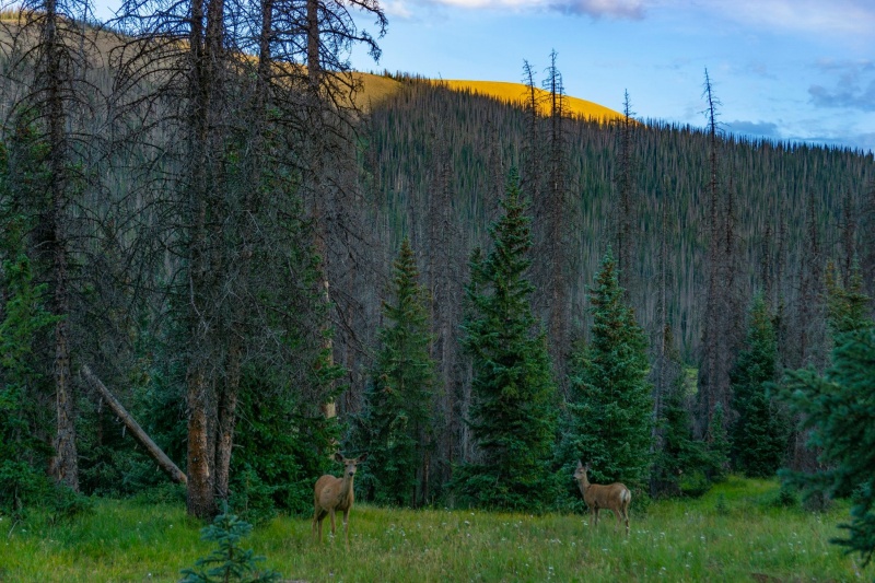
No matter where you camp, the correct trail junction will be obvious. You'll see a large cairn with a stick and a faint trail heading off to hiker's right (southwest) about 100 feet after crossing the third of three minor streams. How I missed it in 2017 is beyond me. The aforementioned stream is the last available water source on the route, so I made camp on Weminuche Pass and set my alarm for 6 a.m. The deer here were insane. A pair of does were my constant companions, supremely curious and even entering my campsite several times. I suspect they would have come right up to me if it weren't for the barking dog. They were joined, at times, by a herd of up to a dozen animals, including two bucks with huge racks. Sadly, I assume their friendliness wasn't the result of my solo commune with nature, but rather stemmed from feeding tourists or baiting bow-hunters.
My happy place.
Turning away from Rio Grande Reservoir.
Bridge crossing over Weminuche Creek (taken on descent in better weather).
The best campsite on Weminuche Pass.
No zoom required.
...or maybe they were just screwing with the dog.
We started up the Opal Lake Trail at 6:30 a.m., about 10 minutes before sunrise. The path begins faint, but turns into a fairly robust trail for most of the first 1-2 miles. You follow it as it climbs steeply up a hill, then traverses around to the south side of a long ridge running up to Fool's Pyramid and RGP.
If you don't take away anything else in this trip report, remember this paragraph. The trail peters out and becomes lost in a maze of deadfall and other use/game trails as soon as you round the corner and start shooting straight west toward The Window and RGP, both of which are now in view. Here's how to stay on the correct route. Ensure you are always a couple hundred feet below the ridge crest that will be above you and to the right. You should not be on any scree or talus at any point here. If you are, drop back down to the grassy forest. Almost every side trail I encountered -- several of which were stronger than the correct Opal Lake Trail -- headed down. Do not go down. If you are going down, stop, because you're on the wrong trail. The Opal Lake Trail either traverses flat or mildly climbs during the entirety of this 1-2 mile section. If you stay on the correct path, the trail will become more obvious again as you pop above treeline. This does require some creative gymnastics under, around and over fallen trees. Eventually you'll ascend to an area of flat alpine tundra with the namesake Opal Lake on hiker's left.
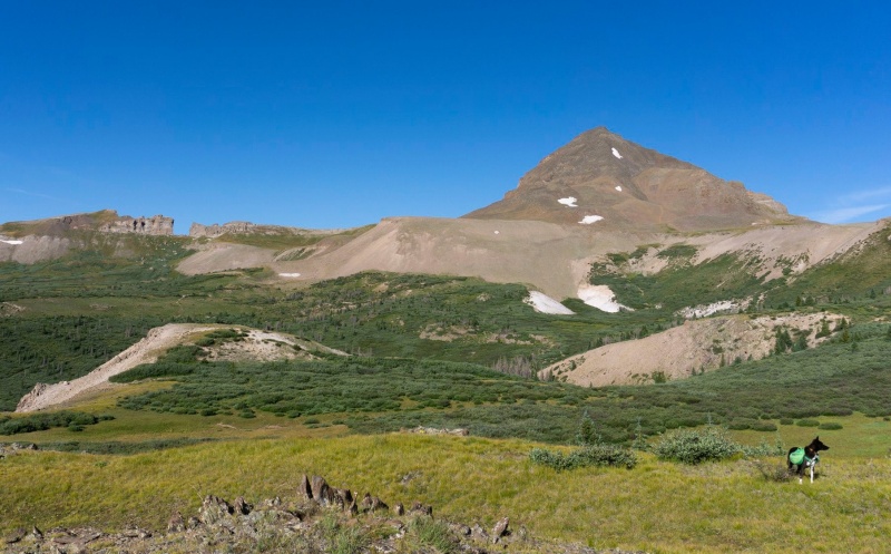
The trail remains easy to follow beyond Opal Lake. The danger of getting lost is over if you've made it this far. Unfortunately, now you get to tunnel through a mile of willows to reach the scree ramp that will bring you to the broad saddle between 13er Fool's Pyramid and Rio Grande Pyramid. You can see the remaining use-route from here if you look closely at RGP's upper slopes. Gerry Roach's 13ers book is a little vague, in that he states to look for an unmarked trail junction that heads up to the saddle when you hit 12,200' in elevation. Well, you'll hit 12,200' in elevation all right, but you still have to continue your flat traverse for about another half-mile before cutting upward. Again, if you look, you can see the trails that lead up Rio Grande Pyramid. Use your eyes -- the most obvious-looking path is the correct path.
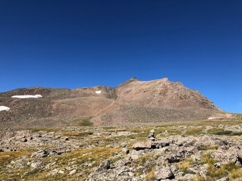
The Window and Rio Grande Pyramid, from near Opal Lake.
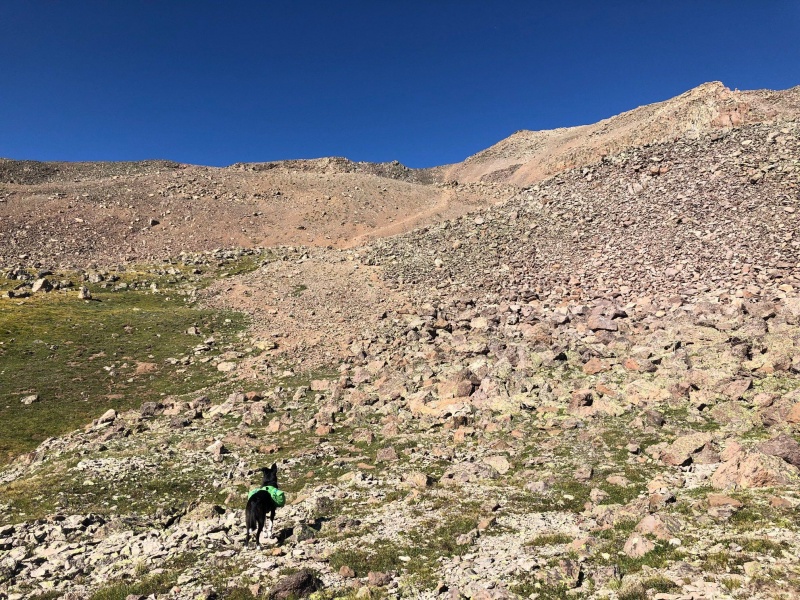
Zia on the trail. You can see the scree ramp you're aiming for slicing up and right about dead center in this photo. The trail contours that direction.
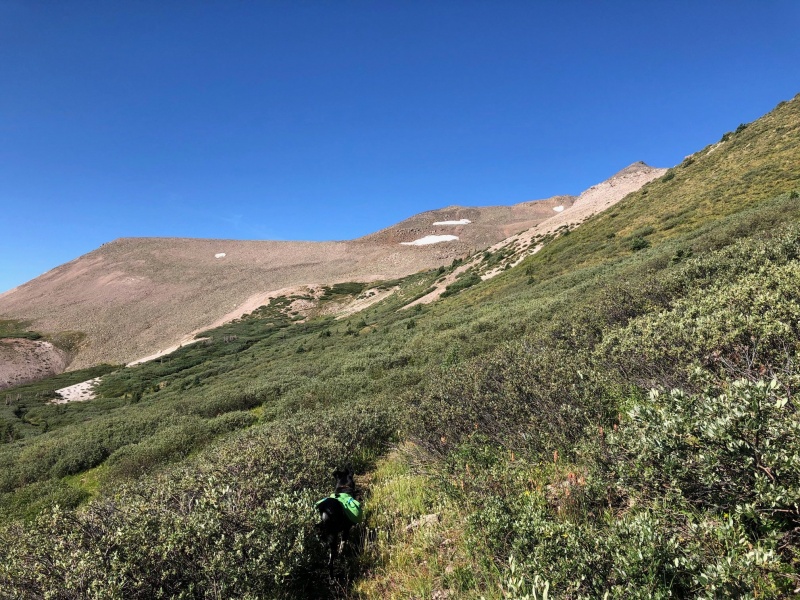
On the saddle, looking up at the final 1,300' of scree and talus.
Here's where the tedium takes over. After so long cruising and contouring along a mostly flat trail, it's time to reengage the legs for the steep slog up that scree ramp you've ogled for the past half an hour. It mercifully passes quickly and deposits you on the huge saddle just east of RGP's summit slopes. Re-lace your footwear and put on your trail gaiters: it's time to go surfin'.
The good news is you can see the use trail you're intended to take; it's one of the most obvious sights on RGP's east slopes. The bad news is, it consists of either ankle-deep scree or completely eroded hard-packed dirt that's apparently coated in bacon grease. All you can do is plod upward. The old scree adage of "two steps up, one step back" rarely applies in real life, but here it does. Expect to slide down half a foot for every step you take. I had good luck staying to the extreme left or right sides of the gully and working up talus or other more stable ground.
You'll receive a brief respite once you reach 13,200' at the top of the scree gully, where you'll curve around a minor ridge point on a small, flat shoulder. The final 600-700 feet is as miserable as it looks from below. The scree gives away to talus that simply behaves like scree. Everything is loose. Test it. Don't climb directly above or below anyone else. If you have a dog, as I did, I'd strongly recommend booties. You won't find a dog with more toughened paw pads than Zia, yet she was stepping gingerly for the next two days -- the first time she's even showed an inkling of soreness despite a peak list pushing 60.
There are small trail(ish) segments you'll encounter, which are beneficial for 50 feet or so before the talus swallows them again. Link these pieces as best you can. I had success more or less trending leftward, then cutting back right in short spurts to ensure I wasn't wandering too far toward the south slopes. No matter how you cut it or who you are, the last 700 feet will take you a while. I'd preach patience, but given that I was alone I was guilty of cussing out a few talus blocks myself, and I don't want to be a hypocrite. Take heart in that the view from the summit will be more than worth the banality.
Zia sizing up the scree gully, with the obvious use trail.
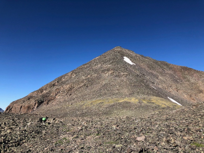
The last pleasant area before 700 more feet of talus. We basically tackled the upper slopes dead on, just left of the snow patch.
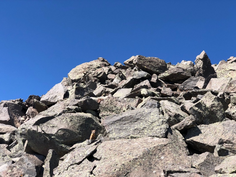
A weasel WOULD live in this hellscape.
Toward Lake City.
Tired dog = happy dog.
Obligatory summit selfie so the 14ers.com Facebook admin team doesn't accuse me of lying.
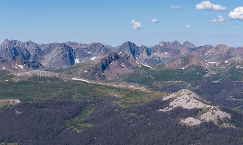
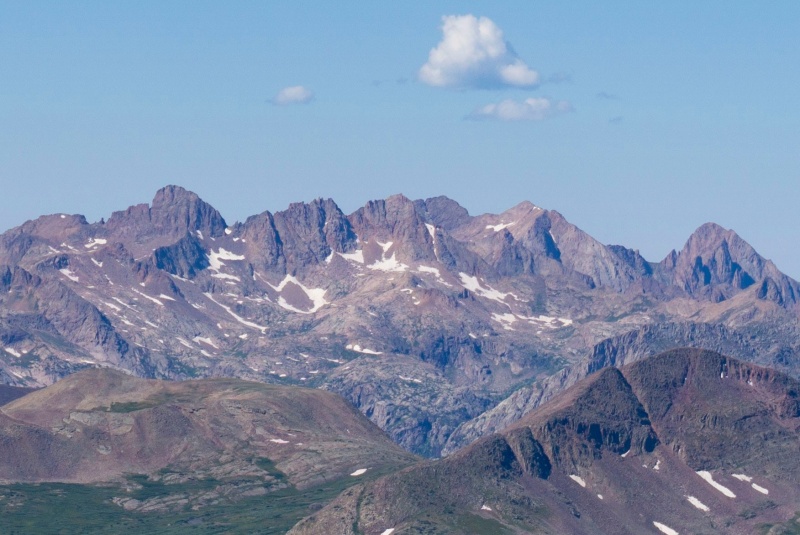
The Grenadiers.
Chicago Basin.
Looking back down toward The Window and the CDT.
We reached the top around 10:15 a.m., a little less than 3 hours after leaving camp. That includes about 15-20 minutes of getting lost on the Opal Lake Trail following various descending use trails. The weather was holding beautifully, so it was nice to hang out for about an hour basking in such impressive vistas. Eventually we had to head down, however, and we took our time navigating the unstable rocks. The scree section was much easier to descend than it was to ascend, and we surfed on down in a fraction of the time it took to climb. Armed with the knowledge of where the Opal Lake Trail does and doesn't exist, we cruised on back to camp in time for a Ramen-noodle lunch with our deer friends. It would have been easy enough to hike out the 5 miles that afternoon, but with the gorgeous weather and pristine backcountry site, I opted to bed down another night before heading back to the car.
I am supremely glad that I've now climbed Rio Grande Pyramid, bringing my Centennial count to #79. I might be even more glad that I don't have to go back anytime soon. If you have the desire and skills, it seems like the mountain would be way more fun in the spring via one of its couloirs. Anyway, I had a hard time finding decent information about this -- the standard -- route, done in summer. I hope this report proves helpful to someone who goes next.
Happy trails!
Thumbnails for uploaded photos (click to open slideshow):
I dunno Jeff...your summit selfie is a bit questionable. I am not seeing a snowy reflection of mountain slopes in your sunglasses, so that's a good start. But as long as you can show me a screenshot of a GPS track, I'll accept it.
I don't recall so much suck when I did RGP. Other than all the dead trees. I do recall great views, especially from 13,278 ("Fools Pyramid") looking at RGP.
And to stand in the window is special.
Nice report Surf. I agree with the new formatting, great job BM!
oh Surf, don't worry about this TR being helpful or not. For me, it absolutely is! I only have so many trips from sea level to Colorado left in me and RGP is on a shorter list...so wild and so remote. I would definitely be attempting it in summer-like conditions. The hike is long enough as to be almost prohibitive as a day hike, yet the photos and description here make it sound worth all of the *$&#@* scree and talus. Thank you for posting.
Handies is often regarded as one of the best 14er views. Another thread perhaps would ask if RGP and Handies have the best views of the Centennials...
Caution: The information contained in this report may not be accurate and should not be the only resource used in preparation for your climb. Failure to have the necessary experience, physical conditioning, supplies or equipment can result in injury or death. 14ers.com and the author(s) of this report provide no warranties, either express or implied, that the information provided is accurate or reliable. By using the information provided, you agree to indemnify and hold harmless 14ers.com and the report author(s) with respect to any claims and demands against them, including any attorney fees and expenses. Please read the 14ers.com Safety and Disclaimer pages for more information.
Please respect private property: 14ers.com supports the rights of private landowners to determine how and by whom their land will be used. In Colorado, it is your responsibility to determine if land is private and to obtain the appropriate permission before entering the property.


")
")
")
")
")
")
")
")
")
")
")
")
")
")
")
")
")
")
")


