| Report Type | Full |
| Peak(s) |
Großglockner (3798m) |
| Date Posted | 09/09/2019 |
| Modified | 09/10/2019 |
| Date Climbed | 09/05/2019 |
| Author | hokiehead |
| Grossglockner Normal Route (04-06 Sept 2019) |
|---|
I'm sure there are multiple members here with far more European mountaineering experience than I, but this is for people like me: you've fallen in love with the mountains from climbing 20 - 40 Colorado peaks, maybe done some Class 3 and Class 4 routes, you find yourself in Europe on a business trip or family vacation, and are thinking "I'd really like to make a summit attempt on a cool mountain in the Alps (or other European range)". My hope is that someone like me has enough information so that you can successfully plan and execute this. I'm happy to answer any more questions in replies or DM as well. Background: I've been on a travel-heavy work assignment taking me to Europe monthly for about 1.5 years now. One of my personal goals for this assignment was "summit an Alp, any Alp". Goal not only achieved, but now crushed. Last year, Rob (a friend from high school), his son and I made a successful summit of the Zugspitze via the Höllental Route (my first via ferrata/Klettersteig). This year, our goal was Großglockner's Normal Route ("normal route" seems to be the European equivalent of "standard route"). We weren't explicitly setting out to checkoff the European highpoints, rather looking for "notable peaks, that push our skills, within a reasonable drive of [my buddy's home in] Munich", but I now have three Euro HP's under my belt, depending on your criteria -- Skafell Pike is the other; it's the highest point in England, but not in the UK (that is Scotland's Ben Nevis). In general, I felt that my experience on CO peaks prepared me fairly well, although I definitely need more expertise on roped glacier travel and would not have attempted that without a more experienced partner. Keep in mind that most of the Alps are further north than CO, so snow stays arouond longer and the weather window is shorter. Both of my Alp summit attempts took place above the 45th parallel.
A few notes on huts: This is not like the 10th Mountain Division Huts that we see in CO. Throughout the Alps (and other European ranges), there are these huts where mountaineers stop overnight in midst of their adventures. These are staffed and equipped for overnight rental. Some are part of multi-day, end-to-end, long routes, others provide a waypoint for a single summit attempt. The advantage of these is that you don't have to carry a tent, sleeping bag, pad, stove, water filter, as much food, etc... as you can book a night at the hut, get a hot dinner, cold beverage, breakfast with coffee, etc.. You can sleep on a mattress and take care of other business on a toilet.
They will also have the most current weather information, and a chance to talk with other climbers (both ascending and descending) for beta.
First, if, like me, your initial reaction to this is "that's not mountaineering! It's cheating" -- get over it. You're in Europe, do like the Europeans do. Second, many of these routes (most?) don't allow camping or bivying -- you must stay at a hut, or push through without an overnight. Third, embrace the benefits I described above! I definitely didn't miss the extra weight.
All the huts have websites and take reservations. All seem to be independently owned, and you will absolutely see variety in facilities, services offered, prices, etc.. I've stayed in three different Alp huts now (one in Germany and two in Austria), and noted some differences and similarities:
In general, the more remote the hut, the less services they will offer (and the more expensive they will be). This only seems fair.
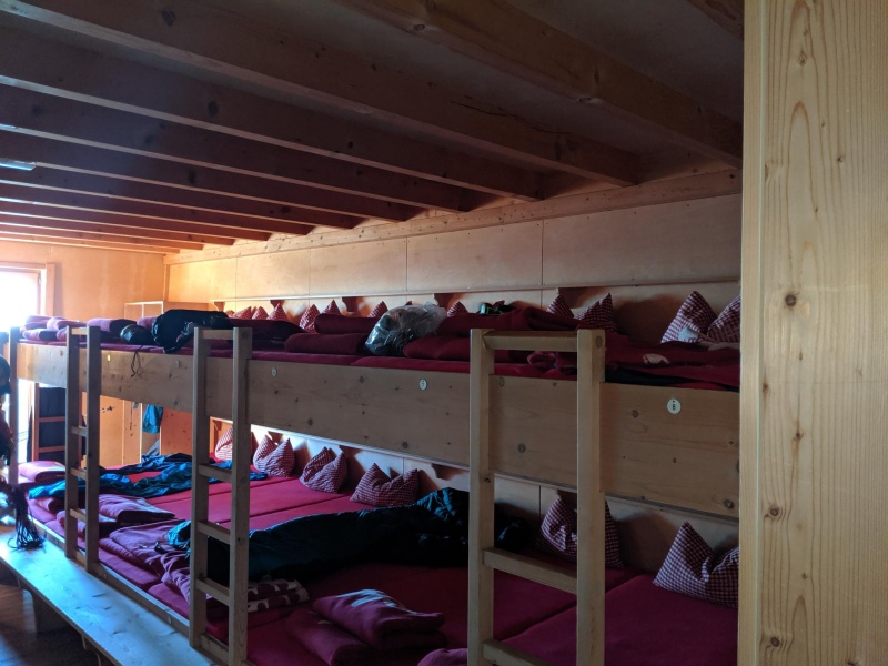
What you do want to bring to the hut is:
The team:
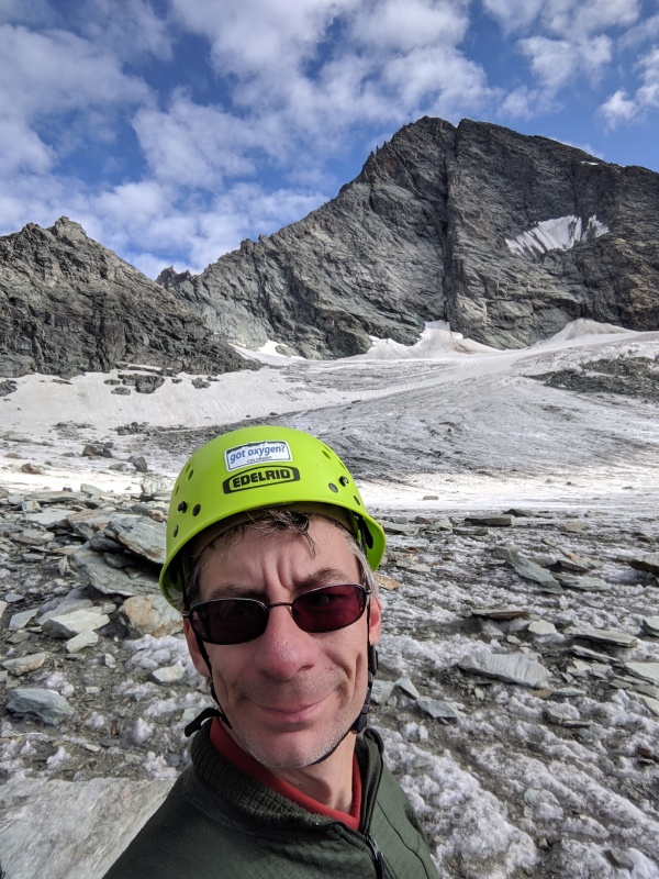
hokiehead -- look at my profile page to gauge my Colorado mountaineering experience. I haven't done anything more technical outside of CO than the mountains mentioned here. My previous glacier experience is limited to the Zugspitze summit (crampons but no axe or rope) and a few times practicing at St. Mary's Glacier. Of the group, I do have the most experience on Class 3 - 5 rock, especially at elevation.
Rob -- my buddy who lives in Munich. He's in great shape but isn't as active in the mountains as me, but has experienced guided trips up Mt. Hood and Mt. Ranier, that included formal glacier travel training he was able to immediately put into practice.
Junior -- Rob's 15 year old son with very limited mountaineering experience, but he's an athlete and in the best shape of the group.
Großglockner original plan:
Wind, snow and rain was coming in Saturday and Sunday, but the forecast looked fantastic for our planned days.
Note: most people do Grossglockner's Normal Route in two days (one overnight), skipping the Stüdlhütte and going direct to the Erzherzog Johann Hütte on Day 1, with the summit push and descent to TH on Day 2. In retrospect, this would've been completely reasonable for a group of our fitness and skill level. We planned the extra day to ensure we were set up for success.
Rob helped me with gear immensely: loaning me a helmet, prusiks and water bottles, buying trail food and renting an axe and crampons for me. Good friend.
Summitpost is the best source I've found for these routes. SP typically has a description of each route, and each hut (with links). Various social media groups on Alpine mountaineering can help with beta as well. Youtube also has a plethora of helpful videos. Camptocamp.org has information as well, but neither they nor SP have as many recent trip reports for Alp routes as 14ers.com has me spoiled into expecting.
The adventure:
Wednesday happened mostly as planned. I overslept a bit at Rob's home, but we had a great breakfast and left Munich by 10:00, arriving at the TH around 14:00 and finished arranging gear. Humorous moment as Junior opens a side pouch of his pack, and discovers leftover food, from LAST YEAR'S climb of Zugspitze, including sausage sticks (the unopened gummy bears and Cliff bars we decided were salvageable). Rob and I shake our heads, roll our eyes, and remark under our breaths, "teenagers". 30 minutes preparing and arranging gear and we were off on a steep hike up a great trail in shorts, sweating like pigs in the heat. Junior ran ahead of his dad and I, as we talked about the trials and tribulations of child-rearing and other "old guy" topics. We arrived at the first hut 2:15 later and gratefully dropped our packs. Cold drinks, a hot dinner and beautiful night skies consumed the evening.
Thursday I woke up first and headed down to the dining room for a cup of coffee while my climbing team slept in a bit. We had a short day planned with lots of buffer... until I checked the weather update. Wind and snow were moving in, expected to arrive Friday around noon, with temperatures dropping notably starting later today. We were prepared for temperatures to drop below freezing, but not for a full winter experience. The decision was made to alter our plans: we would push for the summit today (Thursday), then spend the night at the second hut, rise early on Friday and descend the rest of the way before the weather arrived. The day started with a short hike on a well marked route from the Stüdlhütte to the base of the glacier. Here we stopped to put on crampons and rope up. This is where I discover that the 'pair' of crampons that Rob rented for me, had two lefts (no right). Improvise, adapt, overcome. It took a while to get it on securely (and one stopping to readjust), but I was able to get it to work. The glacier travel with rope and axe went smoothly for the most part, although as noted, Rob had to coach me on knots to secure the coils and it took me a while to get the hang of watching the climbers in front of me and pacing myself to maintain correct spacing. I'm not the dumbest guy, but my brain doesn't process visual geometry -- knots are my nemesis. I was also far less smooth transferring the axe between hands than my climbing partners.
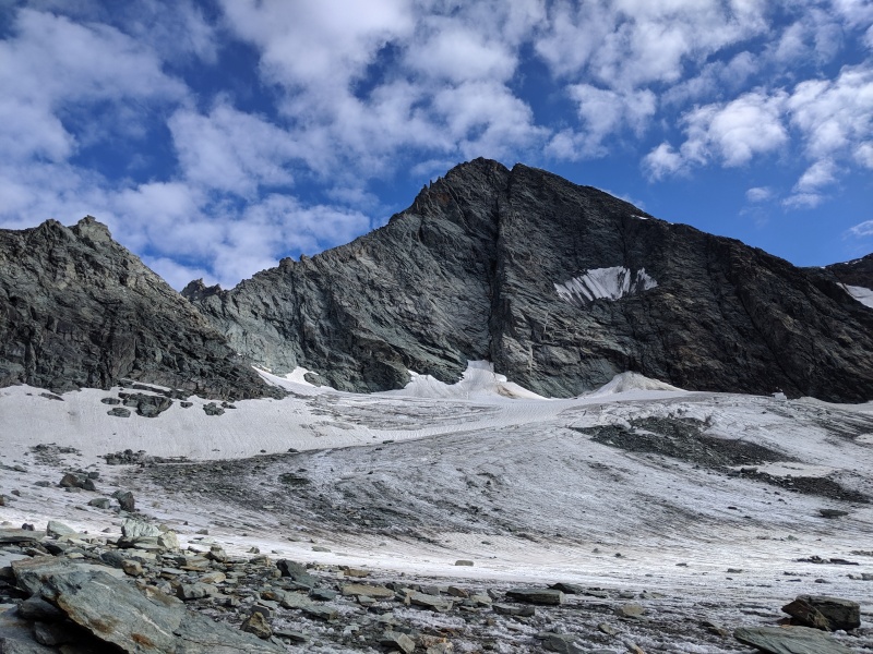
Overall, the glacier travel was not as challenging as I expected. I thought it would be steeper from the descriptions I read. While we never feared for the quality of ice on our well defined switchback route up the glacier, we got a great view of a seriously scary looking crevasse at the top of it. 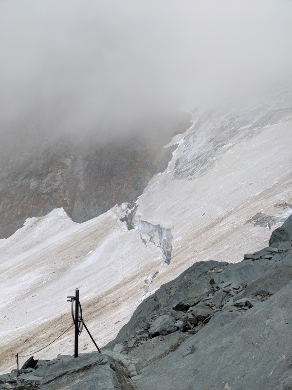
After clearing the glacier, we had a short easy Class 3 scramble (no real exposure) on solid rock to the hut. Two sections had fixed cables as aids, keeping the climb to easy Class 3. The only think that made this challenging was that Rob decided we should leave our crampons on, since there was not a great place to stop and remove them. But, he also suggested that gaining experience on rock in crampons was a good thing, which turned out to be correct. Overall, I found that having crampons on for dry rock was an impediment, but my skill at this improved over the journey as I learned to use the points to help wedge into toe cracks. Another technique at which I could benefit from more instruction and practice. We achieved the second hut (I gave up trying to pronounce that first word and just called it the "Johann hut"), took a rest, ate, checked the weather and confirmed our decision to go for the summit today. Fog was moving in and it looked like we would be deprived of our panoramic summit view, but the forecast was definitely getting worse, so onward it was. At the Johan Hut, we left all the gear (weight) we didn't need for the summit push and headed out around 13:00.
This leg started with crossing a moderately steep snow field (back in crampons with axes) before gaining the dry rocky ridge leading to the first unranked summit (Kleinglockner). This climbing was a more challenging exposed Class 3 (a. la. Kelso Ridge) that also included downclimbing Class 3 on Kleinglockner (I'm lacking a good analog to a CO route that I've done for the downclimb, but it was definitely easier than descending the Hourglass of Little Bear) before the final summit push to Großglockner. This was more exposed Class 3, with occasional fixed cables, routes and iron rungs to keep it to that level. It seems that most groups stayed roped up for this section, and Rob decided it was the correct thing for us as well. I'm not sure I understand the logic here, as we weren't using anchors (there were a dozen or so fixed posts cemented into the rocks, where people would put a loop of the joining rope, so I guess that offered some protection). Staying roped up without anchors on dry rock is a topic I want to research more -- I'm not convinced it makes sense.
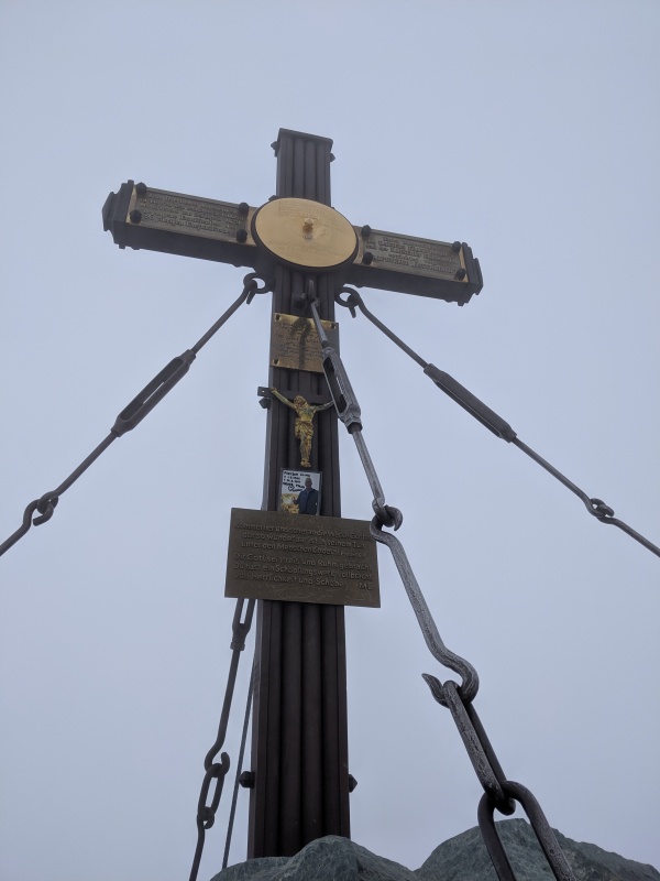
We achieved the summit in thick fog - visibility was limited to several meters in any direction.
Our summit time was short as we didn't like the weather at all, and were sitting in pea soup on a windy summit anyway. We knew we had more Class 3 up and down climbing on the return, and wanted to be back at the hut for dinner. Graupel snow started falling on our way back, an observation all three of us noted but none of us verbalized, until we were back at the hut safely. The trip from the Johan Hut to summit and back to the hut took about four hours. Friday morning we woke up to ~5cm of snow that had fallen overnight. We congratulated ourselves on the decision to make a summit push the day before. There were three groups (at least) that did leave the hut toward the summit that morning, but I wouldn't have felt great about it. I think there's at least a 50/50 chance we would have bailed. We observed that at least two of those groups going for the summit had a professional guide, so I'm guessing they made it.
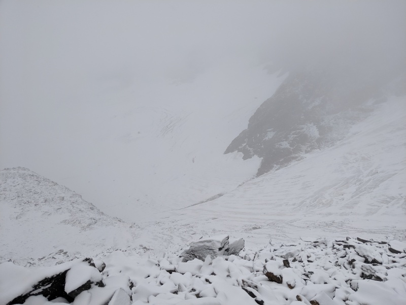
However, we still had a challenge going down. Not only did we have 5cm of snow, but the fog had thickened overnight. Our return journey would be made in very limited visibility. After the unsatisfying breakfast of "rye bread with jelly variety", we packed up and headed out. It started with the Class 3 downclimb of a ridge from the hut to the top of the glacier. Between limited visibility and the necessity of very, very, very careful foot placement on the snow-covered rocky ridge, progress was slow. Recall that on the way up, in good conditions, I called it "easy Class 3". The way down the ridge was indeed slow, but uneventful. My biggest concern for the day was now in front of us. We had to descend the glacier, with no visibility. The image of the crevasse was prominent in my mind, but invisible to my eyes. Fortunately, the snow had not completely covered up the switchback route across the glacier and we safely descended to the bottom, easily following the same route as we did up. After this point, navigation was still difficult in the fog as we lost the trail on the dry rocks, but we managed with map and compass and quickly passed the Stüdlhütte (prominent waypoint that became visible about 50m away, in midst of a map & compass orientation huddle) and then continued hiking down. Shortly after this point, we were sufficiently below the fog to see the trail and navigation stopped being a challenge at all.
About 2km from the TH, there was actually another hut with a full restaurant (popular destination for day hikers). It was now around 12:00 and the Wiener Schnitzel with (what Americans would call) steak fries tasted delicious after a very basic breakfast. After lunch, another 45 minutes back to the TH and the car. A few hours later, on the return trip to Munich, we stopped in Kitzbuhel, a ski town that Rob and family frequent in the winter, at Simple Food and Drinks. Rob says they serve the best burger in Austria, and the guy who owns the place is one of those "never met a stranger" people you'll want to spend ten minutes talking with. Despite cleaning my Schnitzel plate a few hours earlier, I had no trouble doing the same to that burger and I saw no reason to challenge the claim of "Austria's best". I stayed at Rob's again that night and spent a day exploring Munich on my own before heading back to work in the Frankfurt area, while writing this TR (which was way more fun than the mountain of email I still have to face). I forgot how much fun writing TR's can be; I hope I make it a habit.
What's next?
well, I've done a good job of making the most of this assignment, doing and seeing a lot of cool stuff in Europe (not only mountains). But I'm ready to end the intense travel. Yeah, Europe is cool and I'm grateful I've had the opportunity, but at this point its "just another fvcking work trip... with a really long flight... and the added language hassle". I want to push to finish the Colorado 14ers, the Centennials, maybe a few California 14ers, as well as Mt. Hood and Mt. Ranier. Oh, and I do like spending time with my family and friends in Colorado.
However... this assignment probably has another 1.5 to 2 years left and I'll gradually be spending more of my travel time further East in Europe (note to American friends, be careful about the term "Eastern Europe" -- there's a stigma attached to that term -- most Hungarians, Poles, Romanians, etc.. will correct you that those countries are part of "Central Europe"). I'm not intending to start spending the weekends sitting in my hotel room, so my new goals include summitting a peak in the Carpathians as well as the Tatras. Continuing the theme of European high points, Rysy and Vârful Moldoveanu seem like good candidates that I could hit now, solo if necessary. Rob and I are discussing Montblanc, among others, for next summer. The Matterhorn would be a dream, but is logistically challenging unless on a guided tour, as huts book up two years in advance and no camping is allowed.
I really need additional training and practice at glaciated travel, as Rob felt compelled to give me more coaching on axe and roped-travel techniques than either of us would've preferred.
Closing tangent:
The problem of fitting in a mountaineering adventure while traveling for business or a family vacation (vs traveling for the primary purpose of climbing a mountain) is one I'm still working to optimally solve. I don't usually have Rob to help me borrow and rent gear. Bringing a bunch of outdoors gear on a trans-Atlantic flight, while still having room for business clothing, laptop, etc.. isn't practical. A second checked bag is usually $100, never mind the hassle of dealing with three pieces of luggage to/from the airport (I could rent a car if I absolutely had to, but it's usually far easier to just use public transport). A few notes on this (should probably be a topic for a forum post, as I'm interested in how others approach this):
Thanks for reading! Thumbnails for uploaded photos (click to open slideshow): ")
")
")
")
")
")
")
")
|
| Comments or Questions | |||
|---|---|---|---|
|
Caution: The information contained in this report may not be accurate and should not be the only resource used in preparation for your climb. Failure to have the necessary experience, physical conditioning, supplies or equipment can result in injury or death. 14ers.com and the author(s) of this report provide no warranties, either express or implied, that the information provided is accurate or reliable. By using the information provided, you agree to indemnify and hold harmless 14ers.com and the report author(s) with respect to any claims and demands against them, including any attorney fees and expenses. Please read the 14ers.com Safety and Disclaimer pages for more information.
Please respect private property: 14ers.com supports the rights of private landowners to determine how and by whom their land will be used. In Colorado, it is your responsibility to determine if land is private and to obtain the appropriate permission before entering the property.


