Download Agreement, Release, and Acknowledgement of Risk:
You (the person requesting this file download) fully understand mountain climbing ("Activity") involves risks and dangers of serious bodily injury, including permanent disability, paralysis, and death ("Risks") and you fully accept and assume all such risks and all responsibility for losses, costs, and damages you incur as a result of your participation in this Activity.
You acknowledge that information in the file you have chosen to download may not be accurate and may contain errors. You agree to assume all risks when using this information and agree to release and discharge 14ers.com, 14ers Inc. and the author(s) of such information (collectively, the "Released Parties").
You hereby discharge the Released Parties from all damages, actions, claims and liabilities of any nature, specifically including, but not limited to, damages, actions, claims and liabilities arising from or related to the negligence of the Released Parties. You further agree to indemnify, hold harmless and defend 14ers.com, 14ers Inc. and each of the other Released Parties from and against any loss, damage, liability and expense, including costs and attorney fees, incurred by 14ers.com, 14ers Inc. or any of the other Released Parties as a result of you using information provided on the 14ers.com or 14ers Inc. websites.
You have read this agreement, fully understand its terms and intend it to be a complete and unconditional release of all liability to the greatest extent allowed by law and agree that if any portion of this agreement is held to be invalid the balance, notwithstanding, shall continue in full force and effect.
By clicking "OK" you agree to these terms. If you DO NOT agree, click "Cancel"...
With a few weekends of work trips to Denver on the horizon, I decided to try and climb my remaining Front Range thirteeners, all in Rocky Mountain NP. Originally I had planned to tackle them all in one trip with a bivy up high, but the logistics of such a slog with brief technical climbing interspersed seem less than ideal. So, on my first trip in late July I hiked up Alice via Hourglass Ridge. Two weeks later I turned my attention to Powell, Chiefs Head, Pagoda, and Keyboard of the Winds, where at least the west ridge of Pagoda is a known, with a short but reputedly hard-to-protect 5.7 slab crux. It was time to enlist an Elite partner.
I email Ryan about potentially traversing from Powell to Keyboard, and he fires back this response: "Spearhead N Ridge to Chiefshead, descend Stoneman?"
The inclusion of the Spearhead's north ridge represents a typical elitist upping of the ante, wherein the elite climber at least doubles either the difficulty or number of pitches of proposed technical climbing. This is the man for the job. Six or eight pitches of slabby 5.6 granite sounds like my nightmare, but I figure I'll just make him lead it all. We begin paring down gear and settle on simul-climbing with a single rack and a skinny 60m twin.
Off I go to Denver Friday evening; the volume of westbound hordes is shocking, but it's nice to drive against it. We meet up to car camp outside the park, wake up at three o'clock, and are hiking by 3:45. Ryan sets a blistering pace and, after a quick water stop, we arrive at the base of the Spearhead around six. A bunch of other parties are already gearing up for assorted routes on Spearhead; one party launches up the north ridge just as we arrive. We start climbing and they graciously allow us to play through on the first real pitch. Play through, of course, is a term for an action that only Elite climbers (such as Ryan) are privy to--namely, passing another party on a technical route, the most gratifying execution of which occurs mid-pitch.
McHenrys and Arrowhead
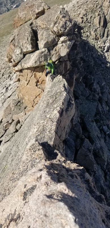
Pleasantly, the reality of this route turns out to be very different from my expectations. Fantastic clean cracks, jugs, and secure stances characterize the entire climb, except for a brief section near the top where Ryan, having decided the climbing isn't hard enough, goes off-route and pulls an awkward, overhanging 5.8 lie-back boulder problem to justify using a Micro Traxion. We finish up the technical climbing in just over an hour from the base with one rack swap (Ryan leads it all), switch to trail shoes, and scramble to the exposed summit of the Spearhead.
Following the upper pitches
Exposure high on the route
On the Spearhead
McHenrys
The imposing north face of Chiefs Head looms a thousand feet overhead. We contemplate our options to tackle it. Though the going looks difficult from our vantage point, we decide to have a look at the traverse. We scramble to the saddle and take a ledge out left (east) of the prow at the base of the north ridge of Chiefs Head. A snow-filled couloir snakes across its northeast face, and we debate inching along nasty-looking ledges to reach the arete adjacent. Instead we head up and right on class 4 or 5 ledges to gain the ridge above the prow. From here, easy scrambling directly up provides access to the north face, where we take a high ledge to the right (west) to join the west ridge, followed by a short hike to the top. This efficient route brings us to the summit an hour after leaving Spearhead.
North ridge/face of Chiefs Head
The views are sweeping, the weather is holding, but we waste no time descending the east ridge of Chiefs Head and are soon faced with Pagoda's intimidating west ridge. Some time has passed since our last technical moves and Ryan needs to do something Elite, and stat, so when he wonders whether a certain knife-edge fin is on-route, I say with confidence that I have seen a photo on Tha Proj depicting an epic hand traverse upon said feature. Ryan rockets across the airy knife edge immediately, only to determine the downclimb doesn't necessarily go in approach shoes.
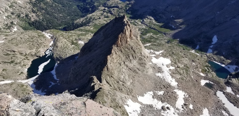
The Spearhead from Chiefs Head
West ridge of Pagoda
Knife edge
After this, we traverse onto the north side to bypass a difficult gendarme and climb back up to find ourselves in a notch with the slab crux directly ahead. It is indeed a slab, with bad deck potential and a death fall below. Here comes a question only Elite climbers are likely to pose: "Do you want the rope?" Ryan asks. Yes I do.
He dispatches the slab like an afternoon sidewalk and I follow, pondering the sense in grade progression for blank rock (although this pitch isn't featureless and is actually manageable). Again we put the rope away. Beyond this section, a huge overhanging gendarme blocks progress up the ridge proper; this time we traverse onto the south side and scramble up some fun and fairly vertical 5th class back to the ridge, where we switch back to trail shoes and hike to the summit of Pagoda.
Can you identify the Elite climber?
Crux slab on Pagoda's west ridge
Final bypass
Chiefs Head from Pagoda
We descend to the Pagoda-Keyboard saddle and hike past Sievers and Jackpot towers to the official Keyboard of the Winds tower (discussion in this report), aka Mrs. Stubbs. Unlike most of the other Keyboard towers, this one requires technical climbing to reach the summit from this ridge. Our beta is that there's a 5.7 corner on the south or east face of the tower. I spy a reasonable-looking dihedral and crack system on the left side of the south face as we approach and decide to do my part. Again we tie in and I lead the tower, which turns out to be fun, if a little dirty, though I think it feels harder than 5.7. Ryan cruises up and says 5.8 or 8-, so it's probably at least 5.10.
Keyboard of the Winds tower on left (not our photo)
Up Keyboard
Our route (not our photo)
The absence of a fixed anchor means we'll need to leave tat. The obvious choice is Ryan's old rack cord, but he opposes the idea for "sentimental" reasons. He goes on and on about how the cord has been on prestigious climbs all over the world. I argue what more fitting tribute could there be for such an accomplished piece of gear than to leave it on an obscure pinnacle? A block ten feet below the summit is tied off and we rappel.
We touch down with a few feet of rope to spare, around thirty feet above the saddle between Keyboard and the next tower (Mr. Stubbs). This gives Keyboard of the Winds at least 120 feet of prominence. The official elevation and interpolated prominence of Keyboard of the Winds are 13,220 and 40 feet, respectively, but in reality the actual summit elevation--based on the saddle contour of 13,160'--must be between 13,280 and 13,320 feet. [Post LiDAR Update: Indeed. The actual measured elevation and prominence of KotW are 13,307 and 150 feet.]
Chiefs Head and the Spearhead
Keyboard of the Winds; summit is the 3rd tower from the gully on the right
While we finish our climb on Keyboard of the Winds, a gentleman hikes up from the Pagoda-Keyboard gully, and we learn that he has come to climb this tower specifically. What are the odds it sees two ascents in the same day? His plan is to rope solo the same route we've just climbed, and we assume he succeeded because he rated it 5.7 on LoJ the next day. There may be a 5.7 route on Keyboard but I do not believe it's the one we climbed. Maybe after we cleaned it. Spend enough time with Elite climbers you'll start to think this way, too. As for me, I'm still waiting for my old man strength to come in.
Ryan just jumped off this thing
All photos credit Ryan except where noted. Cameo by Dom.
Thumbnails for uploaded photos (click to open slideshow):
Caution: The information contained in this report may not be accurate and should not be the only resource used in preparation for your climb. Failure to have the necessary experience, physical conditioning, supplies or equipment can result in injury or death. 14ers.com and the author(s) of this report provide no warranties, either express or implied, that the information provided is accurate or reliable. By using the information provided, you agree to indemnify and hold harmless 14ers.com and the report author(s) with respect to any claims and demands against them, including any attorney fees and expenses. Please read the 14ers.com Safety and Disclaimer pages for more information.
Copyright: Route information, text, risk factors, maps, GPX files, charts, photos, 14ers.com-created map imagery, flythroughs, and other content provided in this route description are copyrighted by 14ers.com and may not be copied, reproduced, republished, distributed, modified, or used to create derivative works without prior written permission.
Please respect private property: 14ers.com supports the rights of private landowners to determine how and by whom their land will be used. In Colorado, it is your responsibility to determine if land is private and to obtain the appropriate permission before entering the property.