Download Agreement, Release, and Acknowledgement of Risk:
You (the person requesting this file download) fully understand mountain climbing ("Activity") involves risks and dangers of serious bodily injury, including permanent disability, paralysis, and death ("Risks") and you fully accept and assume all such risks and all responsibility for losses, costs, and damages you incur as a result of your participation in this Activity.
You acknowledge that information in the file you have chosen to download may not be accurate and may contain errors. You agree to assume all risks when using this information and agree to release and discharge 14ers.com, 14ers Inc. and the author(s) of such information (collectively, the "Released Parties").
You hereby discharge the Released Parties from all damages, actions, claims and liabilities of any nature, specifically including, but not limited to, damages, actions, claims and liabilities arising from or related to the negligence of the Released Parties. You further agree to indemnify, hold harmless and defend 14ers.com, 14ers Inc. and each of the other Released Parties from and against any loss, damage, liability and expense, including costs and attorney fees, incurred by 14ers.com, 14ers Inc. or any of the other Released Parties as a result of you using information provided on the 14ers.com or 14ers Inc. websites.
You have read this agreement, fully understand its terms and intend it to be a complete and unconditional release of all liability to the greatest extent allowed by law and agree that if any portion of this agreement is held to be invalid the balance, notwithstanding, shall continue in full force and effect.
By clicking "OK" you agree to these terms. If you DO NOT agree, click "Cancel"...
My take on the Wetterhorn Uncompaghre combo, trying to fill in some gaps in the earlier beta.
Times
I completed this in just under 8-hours, but I was pushing it in order to beat the weather. I might have gone out too hard as I was really lagging up Uncompahgre which I did as my second peak.
5:00am: Matterhorn Creek 4WD Trailhead
7:30am: Wetterhorn Summit
10:00am: Rock Chair
11:25am: Uncompahgre Summit
12:20pm: Rock Chair
1:05pm: Matterhorn Saddle
1:50pm: Trailhead
Peak Order
Roach describes this route with Uncompahgre first. One advantage of this is that you knock off the furtherest peak up front. If the weather catches up with you can bail on Wetterhorn, which is definitely how it played out in my mind as I tried to guess the clouds before committing to Uncompahgre knowing I still had 9 miles still to go. If you did Uncompahgre first, I’d recommend taking the direct line from the Matterhorn Saddle to the Wetterhorn trail even though finding the livestock trail would be difficult from that direction: the going is easy so finding your own way would be preferable to dropping 500ft down the Wetterhorn Trail - Ridge Stock Driveway (233) junction. The drop from the Saddle to the stream crossing before joining the Wetterhorn trail is around 200ft.
Wetterhorn Crux
This was much less scary than I anticipated. At no point did I feel a fall would be fatal and the staircase description is apt. I took the catwalk just to test the exposure, but continuing straight up would have been easy. Exposure is a very subjective thing, I think being in a gully rather than on a ridge helps me, but the catwalk was not a challenge. Maybe walking the ledge to the start of the Telluride Via Ferrata last week desensitized me: there were some wall-hugging moments on that.
Matterhorn Saddle Shortcut
Finding this shortcut is the key to a good day. Thanks to those before me who have noted this: Here is how I would describe it. Descend the Wetterhorn trail to the point where it leaves the boulder field and starts dropping down an open meadow at around 12,400ft. (Thanks to the Colorado Fourteeners Initiative crew who were doing trail work in the boulder field while I was there.)
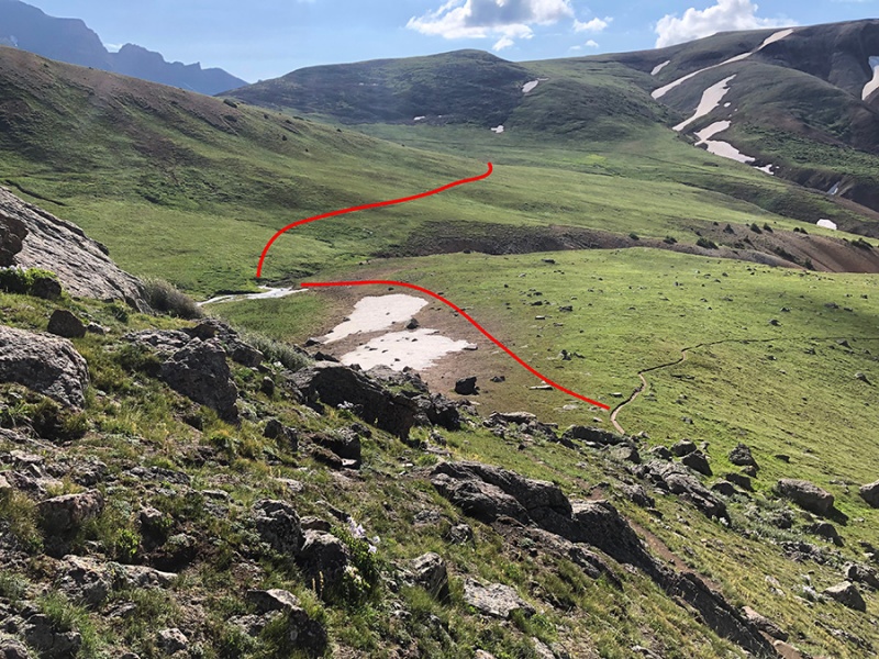
Head to the left towards the stream between the Wetterhorn and Matterhorn. Cross this at the last point before it starts to drop into a steep-sided gully. The stock trail starts on the other-side of the stream and climbs gently until you round the ridge and can see the Matterhorn saddle. The trail is faint but visible under the red line in the photo. Then it ends. I was able easily walk up on an angle to reach the Ridge Stock Driveway 233 just before the Saddle.
The livestock trail to the Matterhorn Saddle just below the red line in this photo.
Scouting the route from 13,000 feet one can make out a faint line higher up. This would require some rockhopping and crossing a scree slope. The livestock trail is easy and only climbs 200ft. My guess is the higher line would not be worth the effort.
Cimarron Headwaters Traverse
On both my Nat Geo map and the Gaia App default map, the trails through here either drop into a gully or climb 300ft in a big loop. It’s not on the map, but there is an obvious and direct line to the Cimarron-El Paso Creek saddle that avoids both mapped options.
The direct line to the Cimarron-El Paso Saddle is more obvious than either alternative trail on the map.
The Rock Chair
This is at 12,600 feet on a small ridge crest about half a mile before you join the official Uncompahgre trail. It is roughly halfway in distance (9 miles) whatever peak you climb first.
My GPS Tracks on Google Maps (made from a .GPX file upload):
Awesome trip report! And thanks for the shortcut tip and photo. I'm thinking of doing this exact combo next week. What was your total elevation gain when it was all said and done?
5,600 on Gaia
5,900 on Strava, but on my watch which might be less accurate
Caution: The information contained in this report may not be accurate and should not be the only resource used in preparation for your climb. Failure to have the necessary experience, physical conditioning, supplies or equipment can result in injury or death. 14ers.com and the author(s) of this report provide no warranties, either express or implied, that the information provided is accurate or reliable. By using the information provided, you agree to indemnify and hold harmless 14ers.com and the report author(s) with respect to any claims and demands against them, including any attorney fees and expenses. Please read the 14ers.com Safety and Disclaimer pages for more information.
Please respect private property: 14ers.com supports the rights of private landowners to determine how and by whom their land will be used. In Colorado, it is your responsibility to determine if land is private and to obtain the appropriate permission before entering the property.


")
")
")
")
")