| Report Type | Full |
| Peak(s) |
Mount Hood |
| Date Posted | 06/12/2019 |
| Modified | 06/13/2019 |
| Date Climbed | 05/30/2019 |
| Author | jchapell |
| Mount Hood Blitz |
|---|
|
In 2014 my wife and I had big mountain plans in the works: Mt. Rainier, maybe some overseas travel, and anything we could fit in the calendar. When we found out early in the spring that she was pregnant with our first child (yay!), we changed plans and went to Mt. Hood for a lower elevation adventure with Timberline Mountain Guides. A big snowstorm the day before our climb that year turned our group around due to avy conditions near the base of the Hogback, so we’ve been trying since then to schedule a return attempt. Five years later, we made it back…
With 2 kids now, we were looking for a short travel window, so scheduled an lightning trip to Oregon: We landed in the evening in Portland, on May 29 drove to the parking lot for a couple hours of rest, climbed, and drove straight back to the airport after the climb (and brunch of course) on May 30. Thanks to some good weather, good conditions, and no flight delays, it all went perfectly.
 View from the plane on the flight in. Wrong side of the mountain to see our route, but still cool to see the giant mountain!
Mount Hood Southside Route: 6.8 Miles, 5470 ft
 The weather earlier in the week had been a bit of a mess, but by the time we arrived in Portland temps were mild, skies were clear (a bit hazy from Canadian wildfires), and maybe most importantly almost no wind at all in the forecast. We got to Timberline Lodge in time to fill out our permit around 9pm and sat in the car relaxing (hard to sleep in a rental car expecting a fun climb shortly!), then set off around midnight. There were probably another 20 cars in the parking lot, with a handful of climbers who had set out before us, and maybe a half dozen gearing up when we set out.
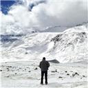
 The summit poking through the clouds on the drive in.
 The view just before parking for a couple hours of rest.
The lower mountain is a pretty boring snow slog, ascending a direct line in the dark about 1k feet in the first mile, then 1500ft in the 2nd mile, and 1900 feet in the 3rd mile. At some point in prior weeks a snowcat had groomed the first 2500 feet, but it by the time we were on it after hundreds of climbers, rain, snows, and freeze/thaws it was broken up icy crust that we opted to put crampons on to avoid the hassle of sliding in and icy footprints. The 3000-4000 overall snow travel of the lower mountain leads to what I call intense “body boredom” – the same motion, in the same speed, leading to an intense desire to change the pattern. Whew!
 Working up the lower mountain with the lights of Timberline below, Milky Way above.
During this time we didn’t see too many people, but spent some time hiking with “Larry,” the father of a father and son (the son had gone ahead) who had climbed the Southside route almost 50 years ago (!) and was now in his mid 70’s (!!), and seemed to have experience in virtually every outdoor location we talked about – The North Cascades, Yosemite, Utah deserts, Rainier, Chicago basin, the San Juans, RMNP, Lofoten Islands, treks in the Alps…and all this time had no trouble hiking at our pace or even a bit faster. Kudos to you Larry.
 Finally at about 9500 feet, after a few hours of hours of sulfury, boring hiking (the wind/temperatures kept the rotten egg smell on the lower mountain), we began to get a feel for the upper mountain, passing Illumination Rock, and getting views of Crater Rock directly ahead, above that the Devils Kitchen, and eventually the upper headwall w the Pearly Gates & summit. Daylight was still a little ways off but there was enough light to make out the features of the massive rocks nearest to us.
 A shot from around 9500 feet looking at climbers ahead beginning the traverse around crater rock.
Just about 10000ft, we crossed up onto the same spot we had turned around in 2014 at Devil’s Kitchen, and had a good snack break as blue hour gave us awesome views of the icy summit crater around us. The mountain farts were strong here, as we were close to smoking fumeroles! A guided group that must have started way before us (we hadn’t seen them all night) was beginning their way up the Hogsback right ahead of us, where they ended up waiting for over an hour.
 Climbers on the left traversing around crater rock, and tiny climber headlamps in the center moving up the Hogsback and at the base of the Pearly Gates.
 Suzanne beginning the traverse, with the large fumerole below her.
 A guided group getting to the base of the Hogsback
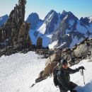
Once we had some good snacks down, we started up the traverse of Crater Rock onto the Hogsback proper. While it steepened from the route so far, we were both energized from the views and more interesting terrain and moved ahead. We could see a couple climbers working around the bergschrund and entering the Pearly Gates up ahead.
 Suzanne moving up the hogsback with two climbers up ahead.
 The early morning crew getting into the pearly gates
 Looking back down at crater rock, and the guided group hanging out at the base of the hogsback.
 The two climbers ahead of us traversing wide around the bergschrund.
 Suzanne moving up the steep hogsback
I’d heard from another climber a couple days ago that the bergschrund had opened just in the last week or so, and by the time we got there it only stretched 15-20 feet into a direct line up the hogsback, though we traversed a solid 30-40 feet out of the way just to be safe and avoid any thinning snow bridge.
 Traversing below the bergschrund
 Looking across the bergschrund - a few snow bridges still somewhat intact across the top!
The snow was pretty firm – excellent for crampons, but a little firm for deep purchase with the spike of our ice axe, with that in mind we crossed back above the bergschrund relatively high. The views were gorgeous!
 Nearing the top of the hogsback
Eventually we got to a steep traverse to get over to the Pearly Gates – which at this point was worn into a narrow ramp allowing us to just walk over. By this time, while the rising sun was on the other side of the mountain, we were getting gorgeous colors in the clouds behind us and getting some great views of Mt. Jefferson.
 We decided to go up the left side of the pearly gates, and waited briefly while the 1 or 2 climbers who were near the top finished – even this early in the morning there was a constant tinkling of icefall, and regular quarter- to golfball-sized snow and ice chunks rained down from the person above us. Once the chute was free we pulled out our second ice axes and started up. The snow conditions were perfect, the light was gorgeous, the views couldn’t have been any better….I wish this portion of the route was 10x longer! We were probably only climbing in the pearly gates for 5-10 minutes before it mellowed out into the last hill before the summit.
 Looking up at the left branch of the Pearly Gates
 About halfway up the pearly gates
 Exiting the closed in portion of the pearly gates, with another ~100 feet of steep snow
 It is a gorgeous summit – we arrived just after 6am, and sunrise was a great time to be there. The skies were a little too hazy to see the peaks to the north, but there was zero wind, and mild temps, so we were happy relaxing and taking photos. We spent 20-30 minutes before heading back down.
    We talked about whether to take the Old Chute down (that was our original plan), but we thought the guided group had chosen the Old Chute to ascend so we hoped to avoid them – Turns out we were wrong...
 Looking down at the entrance to the pearly gates from above
 A climber entering the pearly gates from above
By the time we were 20 feet into the Pearly Gates on the descent (which felt very secure with 2 ice axes, facing in), we saw the guided group was heading up…and it was a bit of a mess. There were a dozen or so on that rope, and after they let us come by on one side of the chute, there was another guided group directly behind them at a somewhat difficult spot for everyone, leading to some picket placement issues and some yelling….we were just glad to get out of the morning traffic jam, but probably waited 10 minutes in all to try and avoid raining ice down on the people below us.
 A quick snap of the morning traffic jam
What to say about the descent? It continued to be fun on the upper mountain in morning light, but by the time we were down below the Devil’s Kitchen, it was a bit arduous, and once the sun softened the snow on the lower snowfields it was just time to put our heads down and power through. I’m sure glissading is an option sometimes, but we saw one climber trying multiple times and only managed to lose 2 nalgenes in the process. In all, it took just under 3 hours to get back to the car.
     Looking back at the upper mountain on the descent. If you zoom in, you can see another traffic jam in the pearly gates
After repacking our bags in the Timberline parking lot and brunch in Sandy, OR we drove on back to PDX for some naps on the airport floor and flights back to Denver. All in all, we were only in Oregon for 23 hours and 15 minutes!
Now that we have done a few of the Cascades, it seems worth comparing:
- Mt Hood: ~6 miles, 5300 ft: We haven’t been training hard this spring, but trying to get out on weekends as possible to dial in our systems & the benefit of living in Colorado. This didn’t seem too hard, just relentlessly steep – it’s a lot of vert, but short mileage, low elevation, & light packs help. It’s basically doing Longs elevation gain in less than half the mileage.
- Mt Shasta: ~12 Miles, 7400 ft: ~6 miles and 2500ft include overnight heavy packs, then 5000 feet with light packs. This was hard for us, even with moderate training & Colorado living but probably because we had the stomach flu the couple days before.
- Mt Rainier DC route: ~15 miles, 9000 ft: Definitely the hardest of all, even with consistent training (though we were living in the Midwest both years). 5000k of vert with heavy packs to Camp Muir is brutal. Getting to the summit actually wasn’t too bad, but the 9000k descent to car destroyed my knees/hips in a way you don’t get here in CO.
This was a fun, fast, and unique climb. It's certainly the trade route on the mountain, but we only felt crowded for one small section. We would certainly go back for another time, or to try another route. These PNW peaks provide some great variety to our CO mountains!
Thumbnails for uploaded photos (click to open slideshow): ")
")
")
")
")
")
")
")
")
")
")
")
")
")
")
")
")
")
")
")
")
")
")
")
")
")
")
")
")
")
")
")
")
")
")
")
")
")
")
")
")
")
")
")
")
")
|
| Comments or Questions | |||||||||||||||
|---|---|---|---|---|---|---|---|---|---|---|---|---|---|---|---|
|
Caution: The information contained in this report may not be accurate and should not be the only resource used in preparation for your climb. Failure to have the necessary experience, physical conditioning, supplies or equipment can result in injury or death. 14ers.com and the author(s) of this report provide no warranties, either express or implied, that the information provided is accurate or reliable. By using the information provided, you agree to indemnify and hold harmless 14ers.com and the report author(s) with respect to any claims and demands against them, including any attorney fees and expenses. Please read the 14ers.com Safety and Disclaimer pages for more information.
Please respect private property: 14ers.com supports the rights of private landowners to determine how and by whom their land will be used. In Colorado, it is your responsibility to determine if land is private and to obtain the appropriate permission before entering the property.