Download Agreement, Release, and Acknowledgement of Risk:
You (the person requesting this file download) fully understand mountain climbing ("Activity") involves risks and dangers of serious bodily injury, including permanent disability, paralysis, and death ("Risks") and you fully accept and assume all such risks and all responsibility for losses, costs, and damages you incur as a result of your participation in this Activity.
You acknowledge that information in the file you have chosen to download may not be accurate and may contain errors. You agree to assume all risks when using this information and agree to release and discharge 14ers.com, 14ers Inc. and the author(s) of such information (collectively, the "Released Parties").
You hereby discharge the Released Parties from all damages, actions, claims and liabilities of any nature, specifically including, but not limited to, damages, actions, claims and liabilities arising from or related to the negligence of the Released Parties. You further agree to indemnify, hold harmless and defend 14ers.com, 14ers Inc. and each of the other Released Parties from and against any loss, damage, liability and expense, including costs and attorney fees, incurred by 14ers.com, 14ers Inc. or any of the other Released Parties as a result of you using information provided on the 14ers.com or 14ers Inc. websites.
You have read this agreement, fully understand its terms and intend it to be a complete and unconditional release of all liability to the greatest extent allowed by law and agree that if any portion of this agreement is held to be invalid the balance, notwithstanding, shall continue in full force and effect.
By clicking "OK" you agree to these terms. If you DO NOT agree, click "Cancel"...
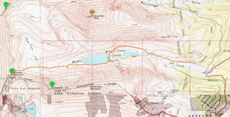
8.8 miles, 2800 feet, when Blue lakes road is closed. Maybe 5 miles, 2200 feet when road is open to dam.
Snowman Couloir about 1300 feet long, about mid 40s angle average, highest angle we measured was 52 degrees.
So a group of friends and I decided on Wheeler Mtn for a snow climb. It had the advantage of being a new peak for all of us, which is a hard thing to find when you have four experienced 13er and 14er hikers. Also the standard route seems to be fairly loose and tedious in summer. Plus, we hoped the trailhead had been opened in the 3 weeks since the last update, saving us 3.5 miles roundtrip.
This route starts from the Blue Lakes TH, the same TH as Quandary west ridge or Cristo Couloir. The Blue lakes road turned out to be unplowed and impassible about 0.25 miles up, just past the last house. So we knew we would be adding about 3.5 miles and 600 vertical to the day.
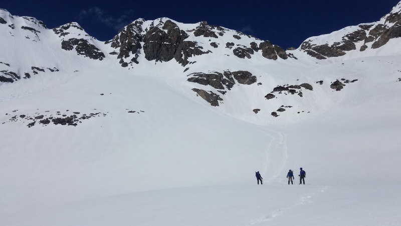
We started an hour before sunrise, up the Blue Lakes road. It was almost completely snow covered with a foot or two, with occasionally a strip of bare gravel on the side. Due to freezing weather the night before, the snow was very supportive and we made good time. After about 1.7 miles, we made it to the dam. Having read previous reports, we decided to stick to the south side of the lake. It was fairly flat, and has no trees, so again we made good time. We brought snowshoes, but didn't wear them.
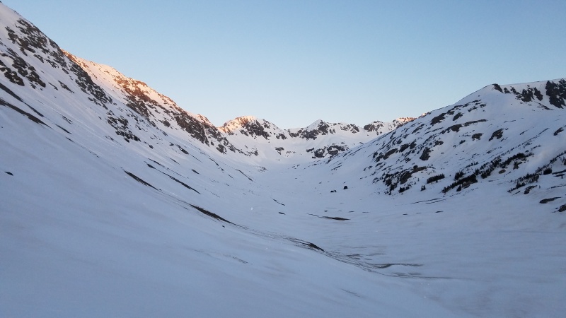
Wheeler in alpenglow. This is JUNE. What a snow year
The NE face of Wheeler gets alpenglow, and then immediate sun. So we knew it was important to get to the couloir and get started before the snow got too warm. The only couloir we had found on the internet was the NE couloir. And even then, there was only a couple reports on it. The downside to this couloir is that it is fairly short, maybe 700 feet. Also, it tops you out on the ridge several hundred feet below the summit. And the information we found was that it was exposed class 3/4 climbing to get to the real summit. However, that couloir was known to be wide, and consistently in the low 40s for slope angle.
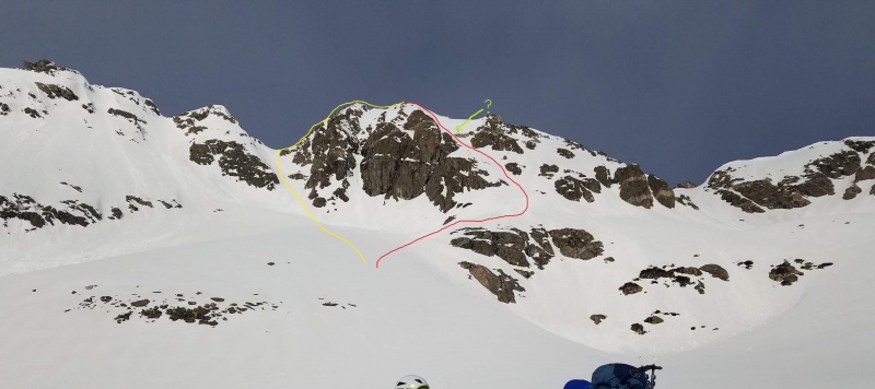
So, as we neared Wheeler, we got excited as we started seeing another possibility...... a larger couloir on the north side of the NE face. We reached the base of Wheeler at about 12,200' and eyeballed our choices. Our only concern with this new unnamed couloir (the red line) was a small cliff band, that went across the couloir about 3/4ths of the way up (The green line on the photo). We could see snow on the side of it, and assumed we could get around it safely, but we knew if we were wrong it would entail a lot of downclimbing, or some sketchy moves across rocks wearing crampons. However, if we could climb all the way up, it appeared to put us right on the summit. Which would save a lot of the aforementioned class 3/4 ice/snow/rock climbing (the NE couloir, the yellow line). And we'd get a longer couloir. Having brought a monocular, we studied it, voted, and decided to give it a go. We stashed our snowshoes and strapped on crampons.
Yellow NE couloir. Red is Snowman couloir. Green is cliff band.
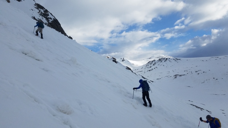
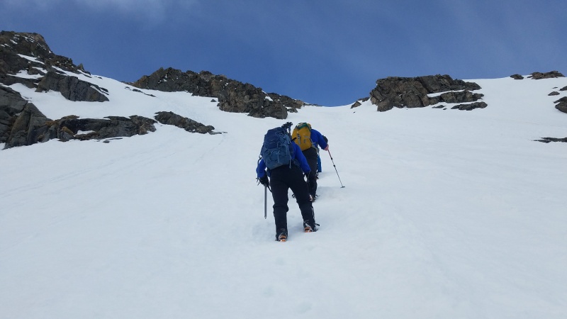
We started up the lower section of Wheeler, which was maybe a 30 degree slope. It was fairly easy, and the snow was just soft enough for us to side step up without having to kick steps. Next we came to a section of avalanche debris from previous wet slides. This was annoying because some sections were very soft, and some were fairly hard. Nothing quite like postholing every third step to sap your enthusiasm.
Old wet slide debris
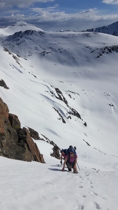
But this was short, and soon we found ourselves on the lower section of the true couloir. We measured it once with a phone app, and found it to be in the low 40s for angle. We could see the slope got steeper ahead, and we still couldn't see the cliff band that might block us off.
We began to kick steps, and the snow was just right. One or two kicks, step up, and repeat. Soon we got to the steeper section, and measured it at low 50s for slope angle. This was the steepest couloir I had been on, and I was glad the snow was in such great condition. And as everyone took turns leading, we soon found ourselves to be getting hot as hell. Soon we were down to T shirts, and continuing up.
About 2/3rds of the way up the couloir, the slope went back down to the low 40s, and we were able to see the cliff band. I was leading at the time and switched from a tired grunting to a happy grunting. The cliff band was nowhere near to closing off the couloir, it left a good 20 feet of snow on the left side, where we could easily go.
Steeper
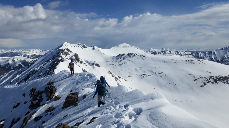
Soon we found ourselves at the top of the couloir. While there was no overhanging cornice, the snow was stacked for a foot or two. Happily, we could step over and easily gain the ridge.
Looking back at Snowman couloir top
The ridge was very snow covered and very narrow. We picked our way across about 50 feet, and found ourselves on the highest summit of the 3 subsummits.
Looking north from summit, towards drift and fletcher
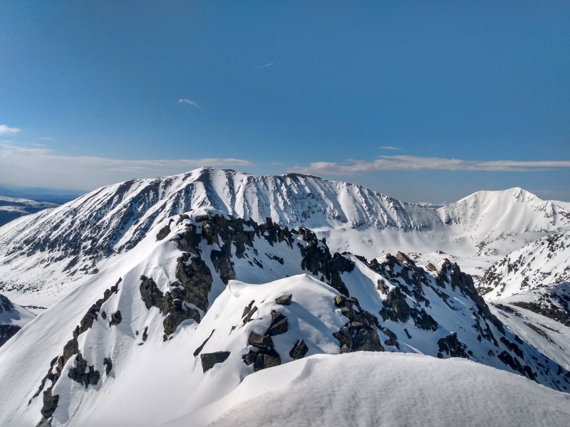
We were very glad we hadn't come up the NE couloir, as the ridge from that side looked a little scary with the rock/snow/ice mixture.
Ridge to south, lower subsummits. Decalibron on horizen.
The wind was very strong and cold at the summit, and soon all the clothes that had come off for the ascent were put back on for the obligatory summit selfie. The views were incredible, and we could see people on the summits of Lincoln and Quandary as well. The cold wind plus the thought of the snow softening further shortened our summit time, and soon we were picking our way back to the couloir for our descent.
We had originally hoped to glissade back down, but the steepness of the couloir put an end to that thought. We downclimbed our steps, finding that as the snow softened that sometimes the step hole would break and we would slide down a few inches, causing a few curse words and tense moments. Once we reached the lower section of the couloir where the slope was down to 40 degrees, we began to carefully glissade down. Soon we passed over the avalanche debris and our glissading speed increased. Soon we were back down to the rock where we had stashed our snowshoes.
Glissading path
After enjoying a break and a couple incidents of snowball throwing, we strapped on our snowshoes and began hiking back down the valley. The snow was soft enough at this point that the snowshoes were very helpful.
Back to TH
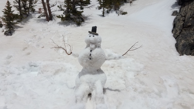
We watched several people glissading down Cristo couloir on Quandary. Soon we made it to the lake, where we celebrated our victory over the unknown couloir by building a very quality snowman. In his honor, I named our newfound couloir the "Snowman Couloir"
Snowman
It began snowing, showing us that the mountain gods approved our naming of the couloir.
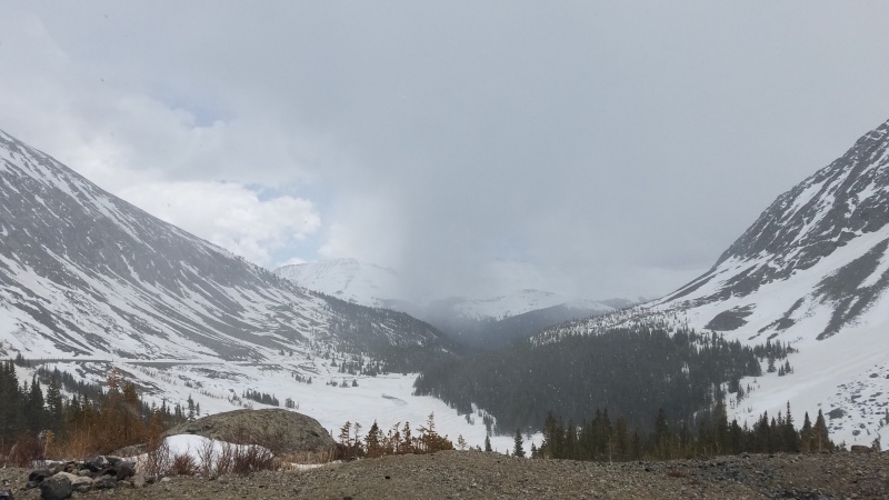
Snowy road walk
Soon we headed back down Blue lakes road to our cars, passing all the day hikers in yoga pants and shorts heading up into the snow. It was a great day.
Approx route
Thumbnails for uploaded photos (click to open slideshow):
You are correct - the summer route is tedious - I like your choice much better. And the line "Nothing quite like postholing every third step to sap your enthusiasm." kinda says it all.
Bummer I couldn't make it... I don't think I would have been anywhere close to the Roaring Fork Valley for my afternoon plans. We will have to get out there in the near future!
You climbed the standard NE couloir on Wheeler which is a popular ski route, surprised you didn't see any tracks? It's described in a guidebook Wheeler
And the trip report you posted, it appears they went down our couloir, but climbed the couloir further north of ours. Ours, the snowman couloir, puts you 30 feet horizontal and about 5 feet vertical from the summit. So there would be no ridge climbing as they describe.
However, it links to a different report that shows someone has climbed the snowman couloir, back in 2007 and they called it two different names. So I guess our couloir is not new, but its definitely not the NE couloir.
http://www.stanwagon.com/wagon/coloski/wishlist/HTMLLinks/wishlist_3.html
That area is locally known as the NE Face. The names in the report off Stan's site are in reference to different, neighboring lines. It's a bit confusing but Meshuggeneh is on an unnamed point just North of Wheeler and Seder Chute is referenced to the hidden exit off the hanging snow face. Regardless it's a really great place.
It's been seeing more traffic as skiers have been venturing into more obscure terrain , but it's never really a busy place. I think I was first back there in the very early 2000s and the place was a ghost town. Still really cool.
I climbed and skied the couloir you went up last year, it went directly from the summit. Popular line, there was another party ahead of us. Again, this is line #20 in this guidebook 50 select ski descents
as well as in Fritz Sperry book Guide book #2
Please don't come up with some random names for well established and popular couloir lines in one of the most popular basins in the state. What's next, "discovery" of Polaris?
well established and popular? Not on the internet its not. Search polaris couloir and you'll get dozens of hits. Wheeler couloir search showed one, the NE couloir. Which ours was not. Sorry we didn't have your guidebook. Sounds like ours was the NE face then.
Caution: The information contained in this report may not be accurate and should not be the only resource used in preparation for your climb. Failure to have the necessary experience, physical conditioning, supplies or equipment can result in injury or death. 14ers.com and the author(s) of this report provide no warranties, either express or implied, that the information provided is accurate or reliable. By using the information provided, you agree to indemnify and hold harmless 14ers.com and the report author(s) with respect to any claims and demands against them, including any attorney fees and expenses. Please read the 14ers.com Safety and Disclaimer pages for more information.
Please respect private property: 14ers.com supports the rights of private landowners to determine how and by whom their land will be used. In Colorado, it is your responsibility to determine if land is private and to obtain the appropriate permission before entering the property.


")
")
")
")
")
")
")
")
")
")
")
")
")
")
")