| Report Type | Full |
| Peak(s) |
Jebal Tobukal - 13671 |
| Date Posted | 12/10/2019 |
| Date Climbed | 04/30/2019 |
| Author | mtn_nut |
| Highpoint of Northern Africa |
|---|
|
This was about as random of a trip as I'll ever take, and it was certainly memorable. I figured a nice write up might help anyone else looking into visiting Morocco in the future. I was funemployed for the month of April. My old employer was bought out 6 months prior, and I did not enjoy working for my new employer. My new employer wasn't doing so well financially after the buyout, and at the start of April I was out of a job with 6 weeks severance, and within two weeks I had new job offers. I decided to take a few weeks between accepting the new job and starting, and I wanted to go somewhere unique. Apparently, the climbing season in the high atlas mountains of northern Africa seems to be best in April and May, as the snow has receded enough to make approach hiking enjoyable, but it hasn't gotten too hot yet. I had looked into these peaks during one of my "daydream" sessions of just looking at faraway mountains that look interesting and remembered hearing about an incident in December with a couple of European hikers in the area. This caused a reaction that made guides and passport checks mandatory in the area, but beyond having to find a guide, the access was still pretty straightforward. The rest of Morocco has pretty easy access and no permit requirements, with the only issue being poor road quality once you get off the paved roads. Getting to and from Morocco was pretty easy. The national airline, Royal Air Maroc (R.A.M.), flys between Casablanca and North America via several routes (Miami, DC, and NYC), Air Canada flys from Montreal, and most major European carriers fly to at least Casablanca, some serving other cities like Marrakesh and Tangier. Morocco is also one of the countries in Africa that has a pretty positive political relationship with the USA, so 90-day tourist visas are free and issued on arrival, making traveling to and from Morocco simple. There are a few big peaks in Morocco, most in the High Atlas mountains near Marrakesh, some to the east of Marrakesh as well. There are also a few shorter but interesting mountain ranges in the north of the country. Last-minute award tickets seemed easy enough as well. R.A.M. partners with Etihad, and for 22k miles each way, it's one of the cheapest transatlantic flight awards available, and the taxes and fees were pretty reasonable. Getting to Miami was the easiest of the three cities R.A.M. flew out of, and a last-minute award flight on United non-stop Denver to Miami got me there Sunday morning. The layover in Miami was complicated by the fact that R.A.M. will not let you check-in or check your luggage more than 3.5 hours before the flight, luckily there is a nice Priority Pass lounge at the Viena in the airport hotel, which made the layover nicer. While at the Miami airport, I received an email from another user on peakbagger that had climbed Jebel Toubkal a few weeks prior, the first peak I was wanting to hike while in the country. He gave me a lot of great detailed information, including the email address of a guide he used. He had climbed the peak in a single day, something I was wanting to do but was on the fence about since my itinerary wasn't fully figured out and wasn't sure if the guides or park officials would allow it. I sent a quick email off to the guide to see if he was available. Finally, they opened up the airport counters and I was able to check-in, check my bag, and go through security. I was also able to also snag a whole row to myself in economy, which made sleeping on the 787 a little nicer on the flight over. 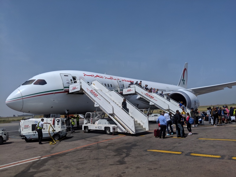
While flying into Marrakesh directly would have made the trip easier, as the mountain is only an hour and a half from Marrakesh, the only flight available Monday to Marrakesh was very late, and it would actually be faster to drive. I needed to get a rental car anyways since I was planning on doing some other adventures to peaks that wouldn't be accessible by bus or taxis later, so I landed, picked up my rental car (a little diesel Dacia Dokker van) and headed off towards Marrakesh. I had read about the speed traps on the Moroccan highways, and sure enough, I found a few but stuck to the speed limit so I didn't get pulled over. There are also police checkpoints along the highway, but it seems like all they want you to do is treat it as a stop sign, and they wave you through a split second later. I guess I didn't look too suspicious. Also, while the roads were decent, all of the non-toll roads are non-divided two-lane highways with all sorts of odd vehicles driving on them, so passing overloaded slow trucks was pretty common. I decided on the way back to pay the toll for the nicer highway, and it wasn't too costly and made the drive a little quicker. I had made a last-minute reservation at one of the hostels in Aroumd called "Roches Armed" after landing in Casablanca and seeing that all of my luggage made it. I had also gotten an email back from Abdo, the mountain guide. He was on the mountain already and was guiding in the morning. He said I had two options, either wait till Tuesday afternoon and hike in with him then, trying for the summit Wednesday morning, or a family friend could meet me Tuesday morning and take me to the huts, and he's climb with me in the afternoon. I replied saying I would prefer to hike Tuesday morning, and he confirmed, saying a family friend named Larbi to meet me that evening. After cruising through Marrakesh and making my way up to the road to Aroumd, I checked my phone for any last messages and turned it off as there wasn't much service off the highway. Finding the hostel ended up being one of the hardest things. I got there well after dark, and while it showed that I was in the correct place, I couldn't find the front door. The road to the hostel is also an extremely steep single lane dirt road with a big drop off, so be careful. However the hostel was in a great location, and once inside the staff was very friendly, making me a great dinner and giving me a nice room to sleep in. I was happy to have earplugs though as the place doesn't have much sound sealing. I was very tired after not sleeping much between the plane and the extra driving from Casablanca. Larby showed up a little bit after I got there, and I gave him the time I'd like to leave in the morning and asked him about conditions, if I needed crampons, etc. He said that a different person, Abdo's brother, would be the one to get me in the morning to take me up to the hut, where I'd meet Abdo. I repacked my bags so I was all set, and went to sleep. 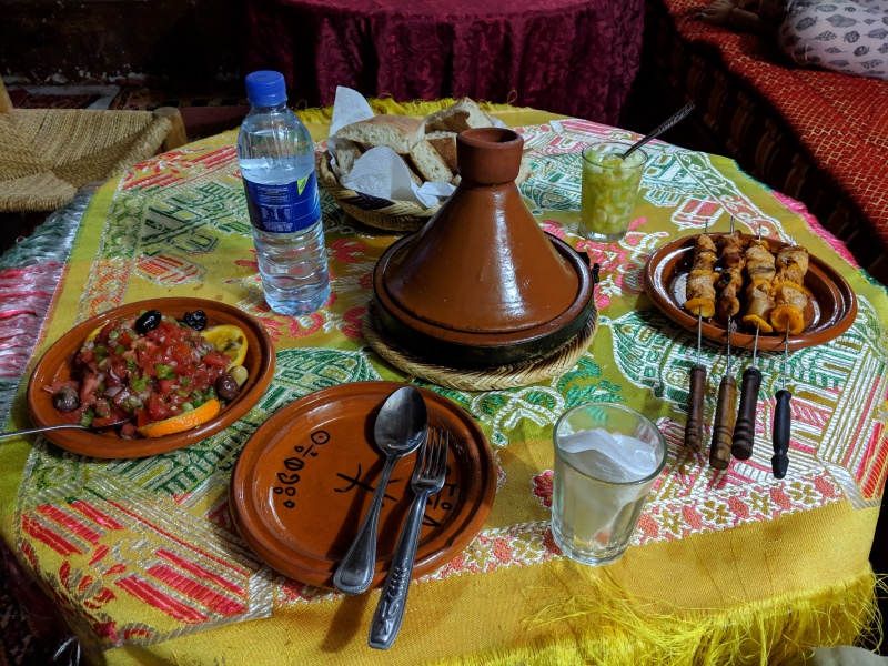
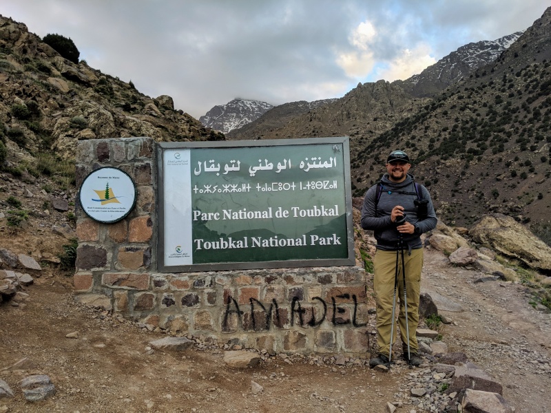
At first light, Abdo's brother showed up, a few minutes early, as I was finishing my breakfast. We hoped in the van and drove carefully over to a parking lot in front of the family's house, which is very close to the start of the trail. We checked in with a guard at the trailhead, who took down my passport information and we started hiking. The first part of the hike was nice. There is a good road that you hike up to get to a small town (31.0985553,-7.9127570) where we had to have a second person check my passport and take down my info, and then hike up to the third passport check. The trail is in good condition and is pretty easy walking. There are normally a lot of vendors selling food, juice, and other items, but because we were hiking so early, most of the shops hadn't opened up yet. They had oranges everywhere for making fresh orange juice, but when I wanted to eat the oranges whole, I got a few funny looks before being able to buy them. 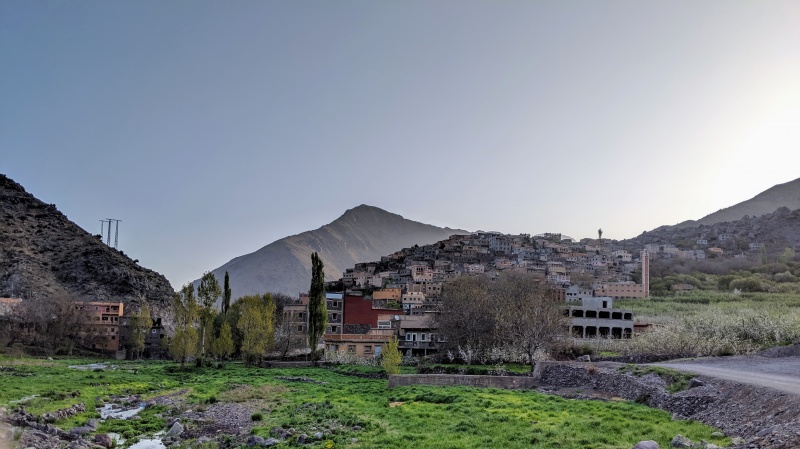
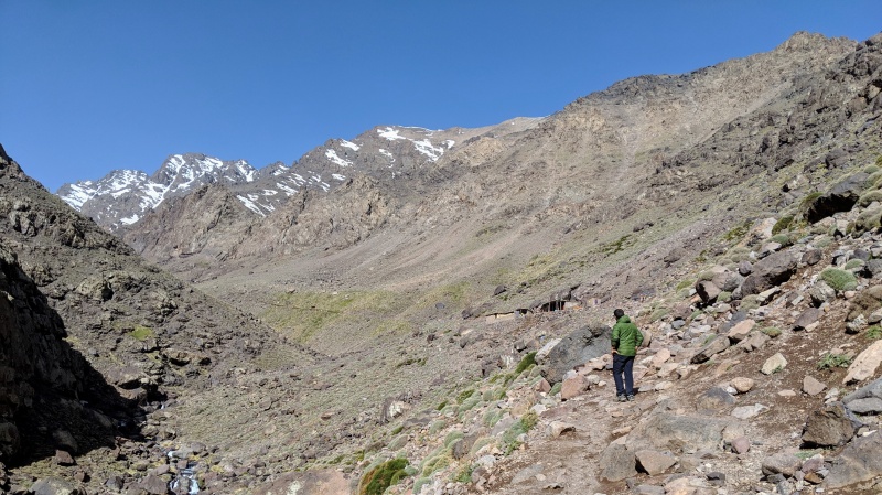
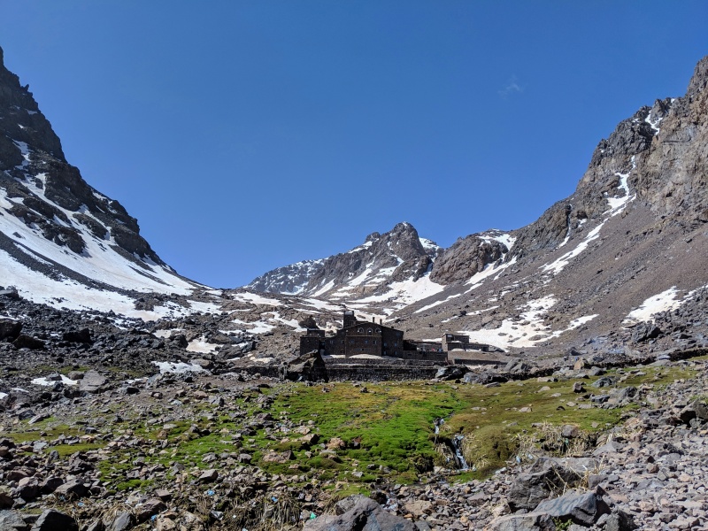
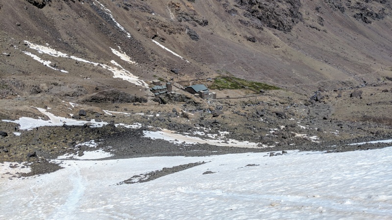
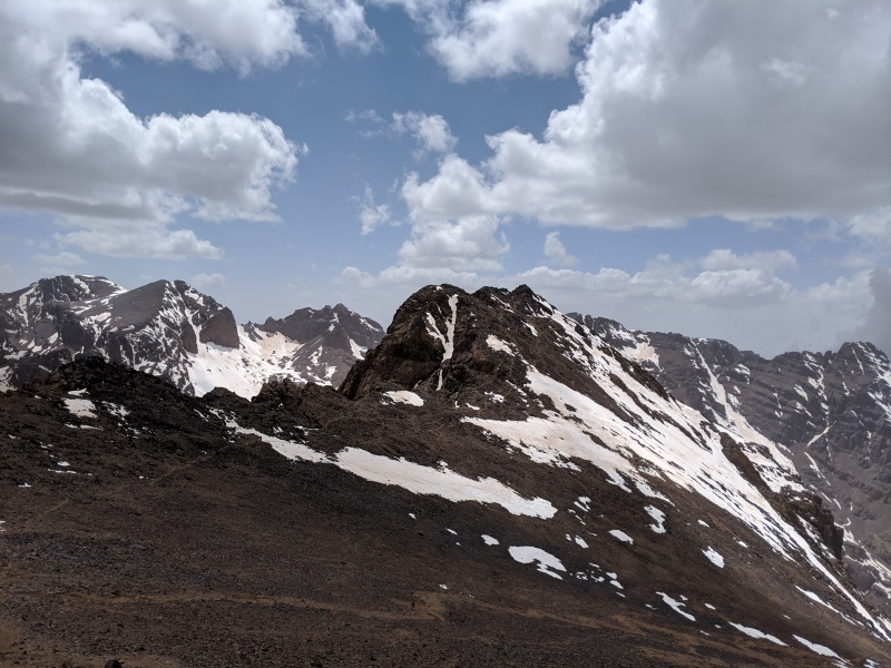
After about 4 hours of hiking, we got to the overnight huts. There are two huts here, one called Les Mouflons, and the other is the CAF hut (French Alpine club). I met Abdo at the CAF hut, as he had just gotten back to the hut from guiding two Spaniards up to the summit. He said I should have lunch and be ready to go in an hour, so I repacked my bag for summiting, leaving my overnight gear and anything else I didn't really want to carry to the summit in my bag liner at the hut. I had packed my overnight gear just in case I was too tired to hike out that evening, but the plan was to do the whole thing in a day. Abdo came out with some sweet Moroccan green tea, and after drinking it we headed up. I explained to Abdo that I was pretty experienced, having climbed lots of 4000m peaks, soloing Mont Blanc, and having been to almost 7000m in South America. He seemed to understand and was pretty hands-off, pointing out the different peaks around the valley as we climbed. If I had been climbing first thing in the morning, crampons would have been required as it was mostly snow-covered from the huts to the summit ridge, but the sun had softened up the snow, so it was easy to boot up the tracks in the snow, although every once in a while I'd punch through and have to posthole up a few steps. I was carrying my microspikes, but never actually used them. Near the saddle between Toubkal and the south summit of Toubkal, the snow lessened and we were mostly on rock and gravel. 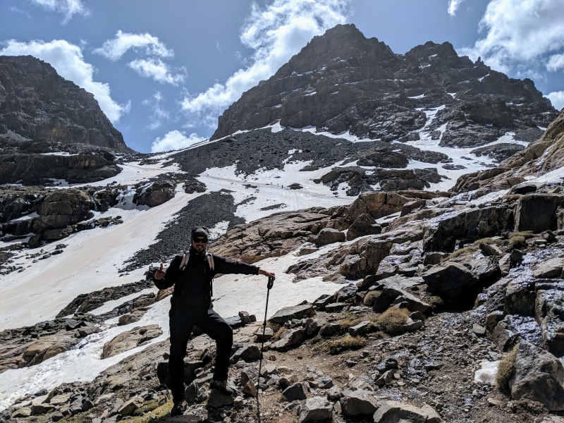

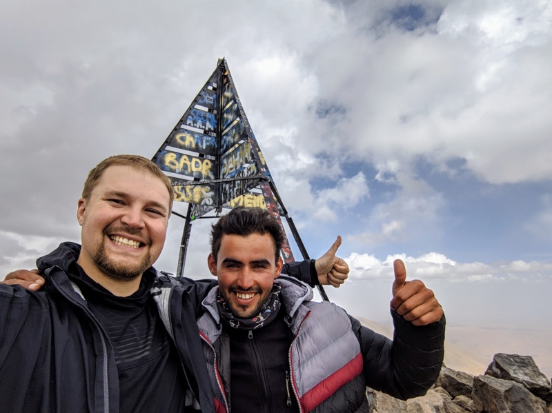
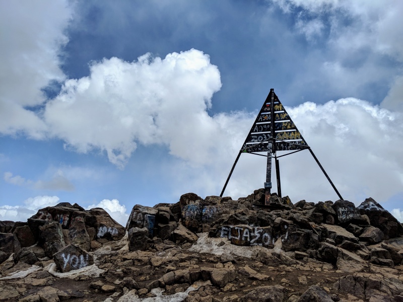
After summiting, taking a few minutes to take some photos and have a snack, Abdo said that we could take a different route back down, or just go back the same way. I asked him to point out the way he wanted to take back down, and since I was tired it didn't look that appealing, as I saw a better route down some gravel scree that looked nicer that connected back to the standard trail. The descent was fast, and when we got back down Abdo grabbed the stuff I had left at the hut and brought out some more tea. The descent re-energized me, and I started feeling much better. I told him I'd like to go back to Aroumd that afternoon, and he agreed, although I could tell that he was hoping I'd stay the night as he'd get paid for another day of guiding and wouldn't have to hike anymore. 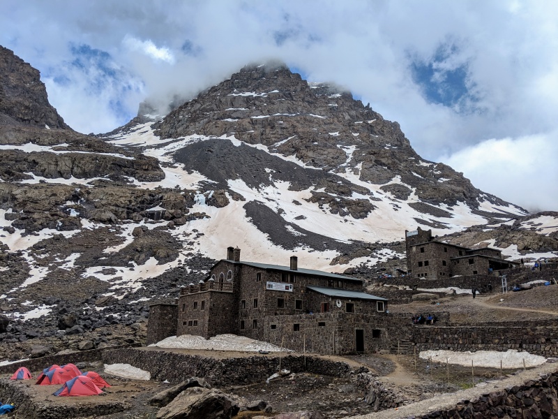
We got back to Aroumd just after sunset, and we stopped over at his family's house where the car was at. After paying him for the day and an extra tip for helping set up everything last minute, he invited me into his family's house where we had some more tea and some different types of bread in a very ornate family gathering room. I thanked him for everything and then headed back to Marrakesh to find a hotel for the since I wanted to be somewhere with a cell phone signal. Thumbnails for uploaded photos (click to open slideshow): ")
")
")
")
")
")
")
")
")
")
")
")
")
")
")
")
")
|
| Comments or Questions | |||||||||||||||
|---|---|---|---|---|---|---|---|---|---|---|---|---|---|---|---|
|
Caution: The information contained in this report may not be accurate and should not be the only resource used in preparation for your climb. Failure to have the necessary experience, physical conditioning, supplies or equipment can result in injury or death. 14ers.com and the author(s) of this report provide no warranties, either express or implied, that the information provided is accurate or reliable. By using the information provided, you agree to indemnify and hold harmless 14ers.com and the report author(s) with respect to any claims and demands against them, including any attorney fees and expenses. Please read the 14ers.com Safety and Disclaimer pages for more information.
Please respect private property: 14ers.com supports the rights of private landowners to determine how and by whom their land will be used. In Colorado, it is your responsibility to determine if land is private and to obtain the appropriate permission before entering the property.


