Download Agreement, Release, and Acknowledgement of Risk:
You (the person requesting this file download) fully understand mountain climbing ("Activity") involves risks and dangers of serious bodily injury, including permanent disability, paralysis, and death ("Risks") and you fully accept and assume all such risks and all responsibility for losses, costs, and damages you incur as a result of your participation in this Activity.
You acknowledge that information in the file you have chosen to download may not be accurate and may contain errors. You agree to assume all risks when using this information and agree to release and discharge 14ers.com, 14ers Inc. and the author(s) of such information (collectively, the "Released Parties").
You hereby discharge the Released Parties from all damages, actions, claims and liabilities of any nature, specifically including, but not limited to, damages, actions, claims and liabilities arising from or related to the negligence of the Released Parties. You further agree to indemnify, hold harmless and defend 14ers.com, 14ers Inc. and each of the other Released Parties from and against any loss, damage, liability and expense, including costs and attorney fees, incurred by 14ers.com, 14ers Inc. or any of the other Released Parties as a result of you using information provided on the 14ers.com or 14ers Inc. websites.
You have read this agreement, fully understand its terms and intend it to be a complete and unconditional release of all liability to the greatest extent allowed by law and agree that if any portion of this agreement is held to be invalid the balance, notwithstanding, shall continue in full force and effect.
By clicking "OK" you agree to these terms. If you DO NOT agree, click "Cancel"...
Grizzly Peak's N Couloir is one of Colorado's classic ski descents, but the Lincoln Creek approach road isn't usually open all the way until late May or early June, and prime skiing conditions may be over by then. I learnt this the hard way a few years ago, and ever since then I've wondered if one could approach from Graham Gulch, on the E side of Independence Pass. (There's an E side route up McNasser Gulch, but that puts you in the wrong place for skiing the N couloir). I tried the Graham Gulch approach on Memorial Day weekend and was pleasantly surprised to discover that it worked well. It's hard to imagine that no-one else has ever done this, but I couldn't find any trip reports that mention it.
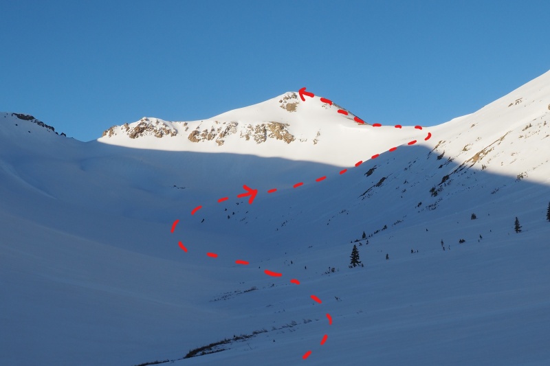
Graham Gulch is the last turnoff on CO-82 before the E side winter closure. There's a parking lot a short distance from the highway, at the Grizzly Reservoir/Twin Lakes water tunnel exit. Starting elevation is about 10,500'. At first you can follow an old road (closed to motor vehicles) that goes roughly parallel to the creek. Look out for a fork about a half-mile from the trailhead, and take the left fork. If you're not paying attention you'll find yourself going up the wrong drainage (ask me how I know this). The road eventually disappears under the snow. After about 2 miles you'll reach tree-line (11,400') and the gulch opens up. From the head of the gulch an ascending traverse leads to a saddle at 12,600' on the Continental Divide, between Graham Gulch and Grizzly Creek. Ski crampons are useful on this section if the snow's frozen.
Route up Graham Gulch to the 12,600' saddle and the start of Grizzly's E Ridge
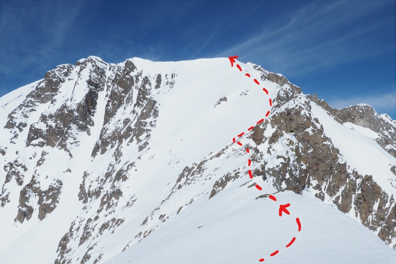
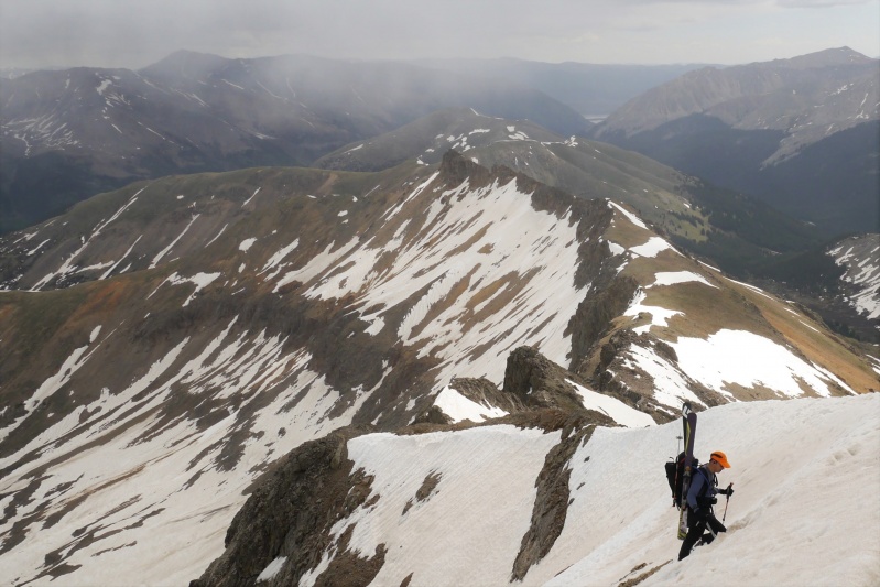
At the saddle you'll get your first view of Grizzly Peak. Take skis off here and bootpack along the ridge, first heading S towards point 13,441' and then W. (This section of the route is described in Lou Dawson's out-of-print "Colorado Backcountry" guidebook, but with an approach from the Grizzly Creek side). From the saddle it looks like the ridge might involve lots of tedious scrambling over loose pinnacles, but the other side is quite straightforward when covered with firm snow.
Final section of Grizzly's E Ridge.
Beyond point 13,441' the E ridge is roughly level for 3/4 mile, and then it climbs up to end at 13,900', right at the entrance to Grizzly's N couloir. (The summit is a bit higher and few hundred yards to the S). Click in to your bindings and enjoy the ride down! But don't get carried away; as soon as the couloir ends, make a sharp right turn followed by a long traverse parallel to the E ridge until you're on the slopes below the 12,600' saddle. Regain about 300-400' to get back up to the saddle.
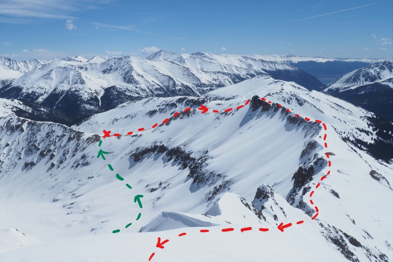
Grizzly's E Ridge (red) and return to the 12,600' saddle (green). Taken from 13,900' at the entrance to the N Couloir.Looking back at Grizzly Peak from the 12,600' saddle
From the saddle, ski back down the way you came.
If it's a warm day it's best to make a very early start. I started around 4:30am, and earlier would have been better. The N Couloir is well-shaded, but the traverse back to the 12,600' saddle crosses numerous slide paths, and the E-facing slopes at the head of Graham Gulch are in the sun from early morning onwards.
Round-trip distance is roughly 10 miles with about 4,200' of elevation gain.
Left car 4:37am 12,600' saddle 7:20am Top of N Couloir 10:12am Back at 12,600' saddle 11:10am Back at car 12:20pm
As a comparison, here's a view of the E ridge from the top of the N Couloir in early June 2013. This is why you might not want to wait for Lincoln Creek Road to open.
Spot the difference!
My GPS Tracks on Google Maps (made from a .GPX file upload):
For posting this. I've been wanting to ski grizzly this year, but was hung up by the same issue, especially given the delayed opening of Indy pass. Looks like a legit option. I spied the couloir from Lackawanna today. What a cool looking line
Yes, I think you're correct that the peak in the CAIC report is Grizzly E, not Grizzly A. I didn't see any signs of slab instability in the couloir on Grizzly A. It had slid naturally a day or two earlier.
Caution: The information contained in this report may not be accurate and should not be the only resource used in preparation for your climb. Failure to have the necessary experience, physical conditioning, supplies or equipment can result in injury or death. 14ers.com and the author(s) of this report provide no warranties, either express or implied, that the information provided is accurate or reliable. By using the information provided, you agree to indemnify and hold harmless 14ers.com and the report author(s) with respect to any claims and demands against them, including any attorney fees and expenses. Please read the 14ers.com Safety and Disclaimer pages for more information.
Please respect private property: 14ers.com supports the rights of private landowners to determine how and by whom their land will be used. In Colorado, it is your responsibility to determine if land is private and to obtain the appropriate permission before entering the property.

")
")
")
")
")