Download Agreement, Release, and Acknowledgement of Risk:
You (the person requesting this file download) fully understand mountain climbing ("Activity") involves risks and dangers of serious bodily injury, including permanent disability, paralysis, and death ("Risks") and you fully accept and assume all such risks and all responsibility for losses, costs, and damages you incur as a result of your participation in this Activity.
You acknowledge that information in the file you have chosen to download may not be accurate and may contain errors. You agree to assume all risks when using this information and agree to release and discharge 14ers.com, 14ers Inc. and the author(s) of such information (collectively, the "Released Parties").
You hereby discharge the Released Parties from all damages, actions, claims and liabilities of any nature, specifically including, but not limited to, damages, actions, claims and liabilities arising from or related to the negligence of the Released Parties. You further agree to indemnify, hold harmless and defend 14ers.com, 14ers Inc. and each of the other Released Parties from and against any loss, damage, liability and expense, including costs and attorney fees, incurred by 14ers.com, 14ers Inc. or any of the other Released Parties as a result of you using information provided on the 14ers.com or 14ers Inc. websites.
You have read this agreement, fully understand its terms and intend it to be a complete and unconditional release of all liability to the greatest extent allowed by law and agree that if any portion of this agreement is held to be invalid the balance, notwithstanding, shall continue in full force and effect.
By clicking "OK" you agree to these terms. If you DO NOT agree, click "Cancel"...
This will be the shortest trip report of this series I am writing on climbing all the 13ers in Rocky Mountain National Park. It is really just an add-on to the longer trip report I have already written about climbing Ogalalla Peak.
When I first climbed Ogallala in August, 2002, it was such a long round-trip day climb--over 20 miles from the Wild Basin trailhead to the summit and back, with over 5,000 feet of elevation gain and loss--that I never repeated the climb. Yet on my descent, I passed a slope that I thought at the time might work as a good descent route down off Ogalalla and down to Junco Lake and from there down to Bluebird Lake and out to the trailhead.
I didn’t have the energy to try a new descent on my climb of Ogallala, though. Really, I was just worn out. I descended the same way I had ascended, back over Ouzel Peak, and then down from Ouzel using Roach’s “North Slopes” route. Of course, tired as I was, that long slog from the low point on the Ogalalla/Ouzel ridge-line back up to the summit of Ouzel, regaining the elevation I had lost earlier that day, was tough. That is why the alternate descent route appealed to me—there was no uphill on the alternate descent to return to Bluebird Lake! Instead of having to re-climb Ouzel Peak, it looked to me that I could just descend to Junco after summiting Ogalalla, and head back to Bluebird from there! That sounded great to me!
To test whether the descent route would work, in September, 2002, after my first climb of Isolation Peak, I felt I had enough energy (And time! I had learned how those long Indian Summer days usually remained fair late into the afternoon.) to give the alternate descent route down from either Ogalalla or Ouzel a whirl. To make a long story short, after climbing Isolation, I climbed Ouzel for a second time, once again using Roach’s North Slopes route. Then I descended from Ouzel south, towards Cony Pass. I knew my alternate descent route started at the Continental Divide just north of Cony Pass.
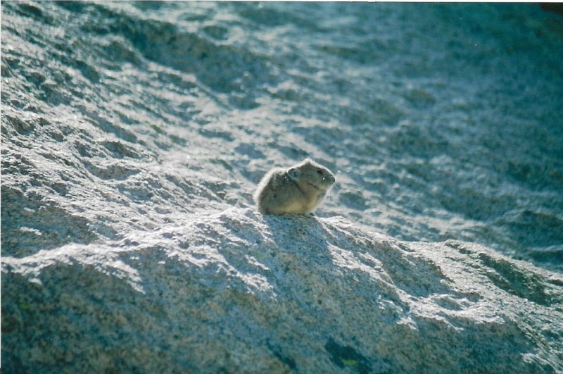
(By the way, for those of you who don’t know what a “cony” is, in this particular case it is another name for the pika, those small little mammals who make their home in rock fields only at high elevations. Unlike the much larger marmots also found in rock fields, pikas do not hibernate. They remain active under rocks and snow much of the winter, and for that reason are very busy all summer making “haystacks” of summer forage to eat later.)
Pika, or Cony. They do not hibernate. In the winter, they eat from "haystacks" of alpine forage they have spent all summer building.
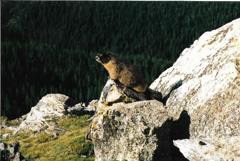
Marmot. They hibernate.
It is only now, seventeen years afterwards, through looking at the photographs I took the day when I succeeded in that alternate descent, that I realize I had found not only an alternate descent route for Ogalalla, but actually a better ascent route as well! If I were going to climb Ogalalla again this coming summer, I would use this route. I would not climb Ogalalla via Ouzel Peak again.
Why? For one thing, instead of being a nearly 20 mile round-trip, this route is only about a 15 ½ mile round-trip. For another, there is less elevation gain and loss, a little over 4600 feet, not over 5000. There is no significant elevation loss that must be subsequently regained, as there is in the route via Ouzel Peak. I would say that a day climb of Ogalalla via Junco Lake is roughly comparable in distance and elevation gain to my climbs of Isolation, with about the same distance from the trailhead, and the same elevation gain.
In fact, if I were going to climb Ogalalla Peak again this coming summer, I wouldn’t do it as a day climb at all. I would make a reservation at the closest back-country campsite, Upper Ouzel Creek, which is below Bluebird Lake and about 5 ½ miles from the Wild Basin Ranger Station and trailhead. I would camp there that night, and start for the summit of Ogalalla shortly after first light the next day.
I only covered this terrain once, in 2004, as a descent, so I am presenting my photos here as an alternate descent route. It wouldn’t take too much imagination to just follow my photos in reverse, and do this as an ascent. This is doable as a round-trip ascent and descent day climb for a strong, well-trained climber. It is also doable (for those of us who are now less strong) as a two day outing with a high camp and overnight at the Upper Ouzel Creek Back-country Campsite, and a climb of the peak early the following morning.
In doing some research on-line about what has already been written about Ogalalla, I did stumble upon another trip report somewhere that contained photos of this route similar to the photos I am about to present to you. So, I don’t delude myself into thinking I “discovered” this route, or have been the only one to use it. Others have ascended or descended this route, but it remains not as widely known as the route via Ouzel Peak. I hope to make it better known through this trip report.
Once again, since most avid hikers and climbers can follow maps and trail signs from the Wild Basin Ranger Station and Trailhead to Bluebird Lake, and back, I will end this descent trip report there. I will begin the report on the Continental Divide, which passes directly over the summit of Ogalalla.
Ogalalla’s summit is at 13,138 feet, and by this route, looks to be a little less than 8 miles from the Wild Basin Ranger Station. Junco Lake lies at about 11,600 feet. So from the summit of Ogalalla, you descend about 1500 feet over a little less than 1 ½ miles to Junco Lake. Junco Lake is a little more than 6 ½ miles from the trailhead. Bluebird is about ¾ of a mile below Junco, with about 600 feet more of elevation loss. Once you reach Bluebird, you contour around its southerly shore. There is an informal fisherman’s trail around the lake that will lead you to Bluebird’s outlet and the formal trail back to the Wild Basin Ranger Station and Trailhead. The distance from Bluebird back to the trailhead and parking area is about 6 miles, with about 2,500 feet of additional elevation loss.
Because I descended this route in September, the fall foliage was coloring up, making my descent that much more enjoyable and beautiful!
By the time in the afternoon I descended this route, clouds were beginning to build. Sometimes I was in cloud shadow, other times in sunlight. That is why some of these photos appear darker than others. There was no thunder, and I just trusted it would not rain until I had at least reached the shelter of trees below. And it ended up not raining at all that afternoon, just threatening to do so.
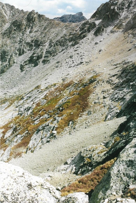
In the next series of photos, you will see the easiest and shortest route from the Divide down to Junco Lake. The first part of my descent was down bare but pretty stable talus. After that, most of the route was down an intermittently grassy slope that again alternated with stable talus. The route is not straight up and down. It goes down to the lake diagonally at a much more gradual inclination and angle.
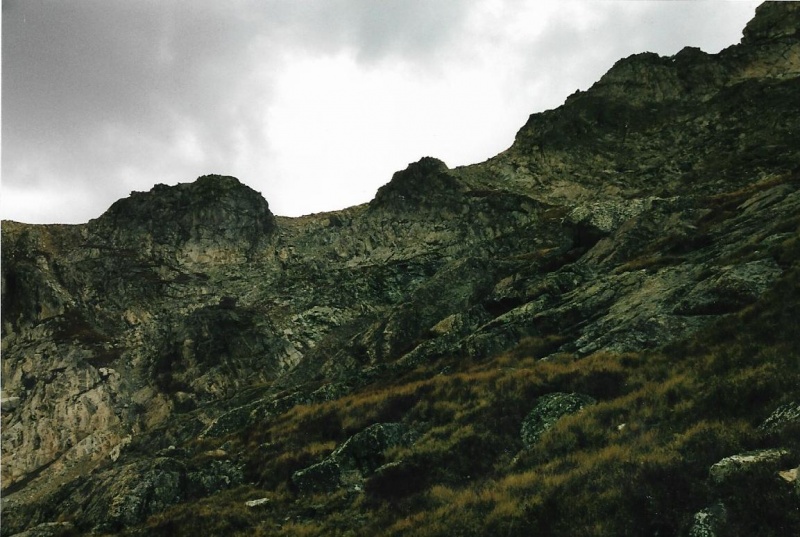
Cony Pass, And a Good Path to Reach It. Elktooth Beyond. My descent route begins near this point.
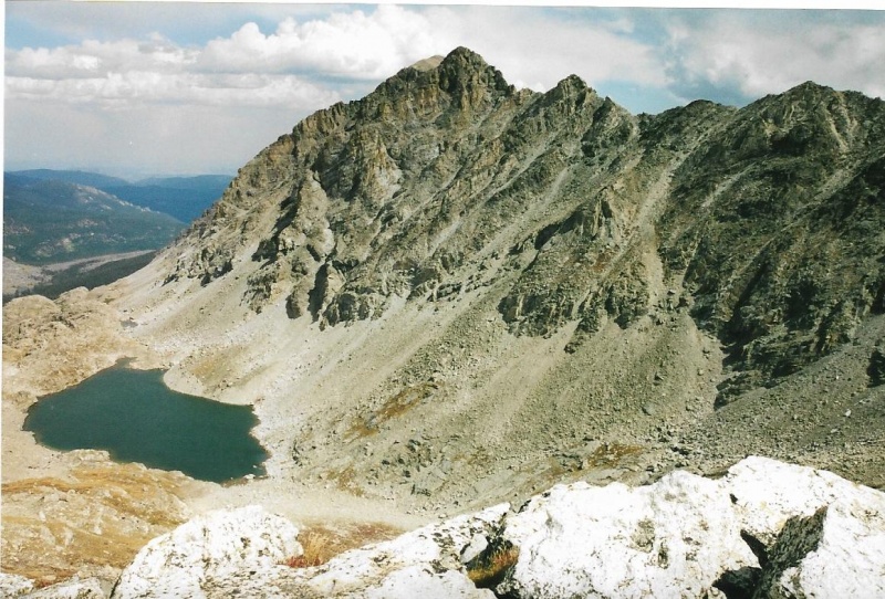
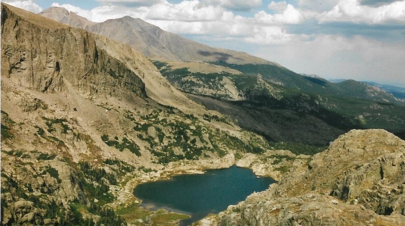
Junco Lake Directly Below My Descent Route. Bluebird Farther Below, Left. This is the slope I spotted, but didn't take, on my descent from Ogalalla.
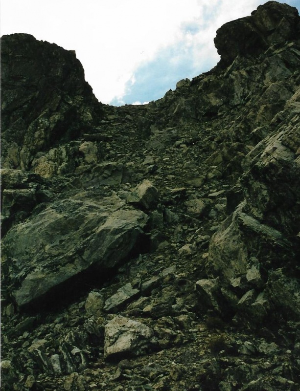
The Continental Divide Is The Skyline. At The Beginning Of My Alternate Descent Route, Looking Back Up.
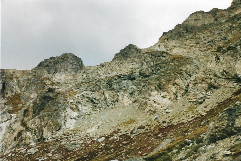
A Bit Lower On My Descent. I Passed Between The Little Knob Center, And The Big Knob Left.
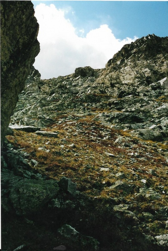
Still Lower. On A Grassy Slope Now.
Even Lower. You Can See The Route Zig-Zags Some, Like A Series Of Switchbacks, Through Alternating Rock And Grass Slopes.
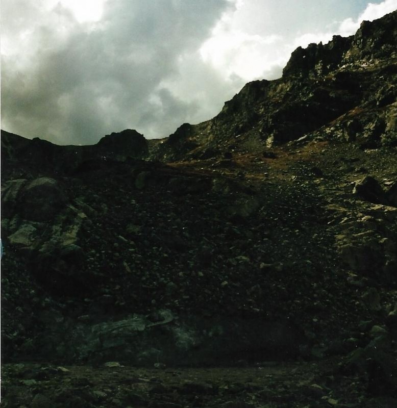
Lower, In Cloud Shadow.
That's the end of the photos looking up. The next series of photos are looking down.
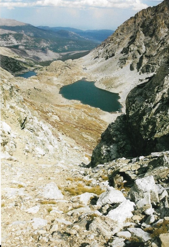
Copeland Mountain Over Junco Lake, From My Route.
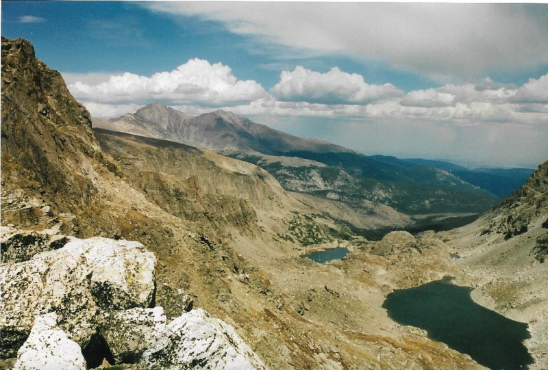
Longs and Meeker In The Distance. Junco Lake Right Corner. Bluebird Lake Distant, Left.
Very Close To Junco Lake, Low On The Descent.
Junco Lake At Last! Ogalalla, Left. Much Of My Descent Route Is Visible In This Photo. You can see why I think this would work as a better ascent route than the route via Ouzel Peak.
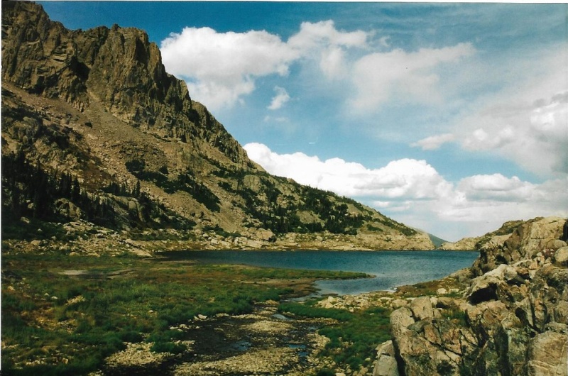
Longs, Meeker, At The Beginning Of My Descent From Junco Lake To Bluebird Lake. Great Views.
Inlet To Bluebird Lake.
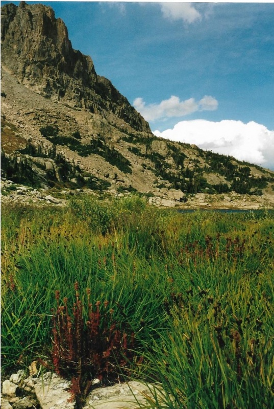
Reeds and Rushes At Bluebird's Inlet Coloring Up In Fall.
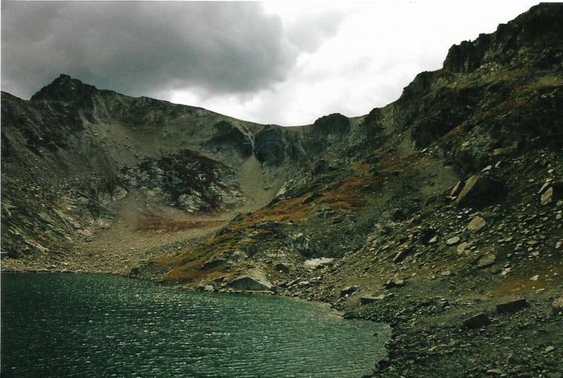
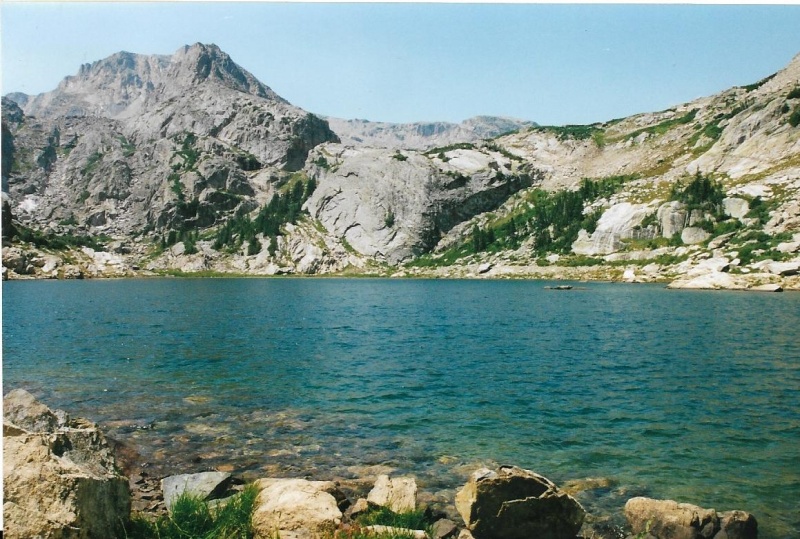
Ouzel Peak Over The Southerly Shore Of Bluebird. See the Yin-Yang symbol in the rock to the right of Ouzel Peak, just above the shoreline?
Though I was happy to have descended successfully from the Continental Divide near Cony Pass via Junco Lake to Bluebird Lake, I still had six miles to hike back out to the Wild Basin Trailhead and Parking Area! My long day that had begun with my first climb of Isolation Peak wasn't over quite yet! Miles to go before I rest!
Thumbnails for uploaded photos (click to open slideshow):
I have a reservation at Upper Ouzel the first weekend of August and was doing some research on the 13ers when I stumbled on this report you just posted! Excellent timing and thanks for sharing this nice alternative. I was looking at Furthermore's report which does all three 13ers in one go but not sure I have the desire/energy to do all that in one day.
Meaning "What is a "cony?" (one of my wife's favorite creatures by the way).
I used to participate in a now defunct on-line forum dedicated to RMNP
where a few of the members were absolutely obsessed with getting to
Cony Pass. Eventually they succeeded and as I recall (maybe incorrectly)
they went up to the pass via Junco Lake (but I think they veered south
from your route up to the Divide) and went down the other direction
by Cony/Hutcheson/Pear Lakes and out by the Pear Lake trail. Why they
were obsessed with the Pass I never understood. Ouzel and Ogalalla
seem like far more worthy objects of obsession. You've provided great
beta for anyone thinking about climbing Ogalalla Peak and a few of your
photos are truly "magazine worthy." Thanks for the entertaining read.
Caution: The information contained in this report may not be accurate and should not be the only resource used in preparation for your climb. Failure to have the necessary experience, physical conditioning, supplies or equipment can result in injury or death. 14ers.com and the author(s) of this report provide no warranties, either express or implied, that the information provided is accurate or reliable. By using the information provided, you agree to indemnify and hold harmless 14ers.com and the report author(s) with respect to any claims and demands against them, including any attorney fees and expenses. Please read the 14ers.com Safety and Disclaimer pages for more information.
Please respect private property: 14ers.com supports the rights of private landowners to determine how and by whom their land will be used. In Colorado, it is your responsibility to determine if land is private and to obtain the appropriate permission before entering the property.

")
")
")
")
")
")
")
")
")
")
")
")
")
")
")
")
")


