Download Agreement, Release, and Acknowledgement of Risk:
You (the person requesting this file download) fully understand mountain climbing ("Activity") involves risks and dangers of serious bodily injury, including permanent disability, paralysis, and death ("Risks") and you fully accept and assume all such risks and all responsibility for losses, costs, and damages you incur as a result of your participation in this Activity.
You acknowledge that information in the file you have chosen to download may not be accurate and may contain errors. You agree to assume all risks when using this information and agree to release and discharge 14ers.com, 14ers Inc. and the author(s) of such information (collectively, the "Released Parties").
You hereby discharge the Released Parties from all damages, actions, claims and liabilities of any nature, specifically including, but not limited to, damages, actions, claims and liabilities arising from or related to the negligence of the Released Parties. You further agree to indemnify, hold harmless and defend 14ers.com, 14ers Inc. and each of the other Released Parties from and against any loss, damage, liability and expense, including costs and attorney fees, incurred by 14ers.com, 14ers Inc. or any of the other Released Parties as a result of you using information provided on the 14ers.com or 14ers Inc. websites.
You have read this agreement, fully understand its terms and intend it to be a complete and unconditional release of all liability to the greatest extent allowed by law and agree that if any portion of this agreement is held to be invalid the balance, notwithstanding, shall continue in full force and effect.
By clicking "OK" you agree to these terms. If you DO NOT agree, click "Cancel"...
This is a very easy class 1 hike. There is maybe a single step that's class 1+. Signage all the way and very well marked trail.
I went on a Saturday and it was busy. Almost as busy as a front-range 14er on a weekend with good weather. Apparently you can ride a horse to the top but I didn't see anyone trying it. It's about 4.25 miles each way and 3,000 feet elevation gain. The ascent is almost 100% uphill so you don't really have to re-gain any elevation on the way down which is nice.
I started out at a good clip and then slowed down a little toward the end. Finished with an ascent time of 1:44. Surprisingly the descent took me exactly 1:44 as well but I've always been slow on descents. I always keep track of my pass ratio on the ascent. I went 42-1 (darn trailrunner passed me!). For reference I generally get about a 10-2 or 10-3 ratio in Colorado.
There is a campground near the summit but I'm not sure why anyone would want to make this a multi-day trip.
You have to pay at the visitor's center, $7 per hiker who is 16 and over. Or, it's free for everyone in your group if someone has a national parks pass (As I understand it). You have to pay to get a sticker for your car.
The trailhead is far away from the only parking lot (for non-campers) at the visitor's center and it's uphill to get there so if you have a weak link in your group it would be worth it to drop that person off at the trailhead, go park, and then meet them at the trailhead.
I wouldn't recommend people from Denver leave all the Colorado mountains to come do this one but if you happen to be anywhere near the area it's definitely worth it. Honestly, the views on the ascent and the summit are better than some 14ers.
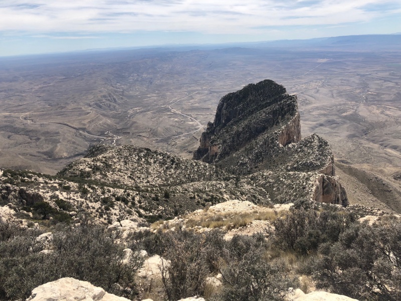
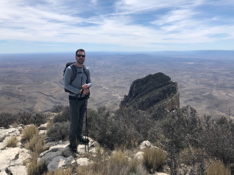
Picture taken from the summit looking at El Capitan.Same
Thumbnails for uploaded photos (click to open slideshow):
Well, it isn't the Lubbock natural high point, but it will have to do. I daydream about a southwest tour that includes Guadalupe, Truchas, Taylor, Wheeler, Humphreys, Charleston, etc. Someday. Question: how warm/cold was it at the trailhead and up top? Thanks!
I checked the montain-forecast.com weather the morning of and it said the high was going to be 44. It was probably 60 at the summit (at about 2pm). I don't know if that's a consistent thing that they are so off and in that direction but it certainly was that day.
I was up there Feb 20. With 50 mph wind and temps in the low 30's, it didn't take long to get cold. I imagine summer temps are pretty tough and, with no water on the trail, make it a challenging hike. My son and I ventured to the summit of El Cap which was an adventure. Not difficult but a lot of bushwhacking and it took a lot more time than we expected.
Beautiful views of the Permian Basin and the Delaware Mountains from the summits.
I was up there March 17th for St Patrick's Day. Drove in the night before, hiked, and drove back to Colorado Springs. There was a dusting of snow. If you're in the area make sure you visit Carlsbad Caverns as well. In fact, you can hike Guadalupe Peak in the morning and be at the Caverns well before noon.
https://wildwandererlmc.wordpress.com/2019/03/18/texas-highpoint-guadalupe-peak-8749/
Check out McKittrick Canyon next time you are up there. Two buddies and myself ran from Pine Spring TH to McKittrick and back and it was phenomenal. Did yall attempt Humboldt on Friday?
Caution: The information contained in this report may not be accurate and should not be the only resource used in preparation for your climb. Failure to have the necessary experience, physical conditioning, supplies or equipment can result in injury or death. 14ers.com and the author(s) of this report provide no warranties, either express or implied, that the information provided is accurate or reliable. By using the information provided, you agree to indemnify and hold harmless 14ers.com and the report author(s) with respect to any claims and demands against them, including any attorney fees and expenses. Please read the 14ers.com Safety and Disclaimer pages for more information.
Please respect private property: 14ers.com supports the rights of private landowners to determine how and by whom their land will be used. In Colorado, it is your responsibility to determine if land is private and to obtain the appropriate permission before entering the property.
")
")


