Download Agreement, Release, and Acknowledgement of Risk:
You (the person requesting this file download) fully understand mountain climbing ("Activity") involves risks and dangers of serious bodily injury, including permanent disability, paralysis, and death ("Risks") and you fully accept and assume all such risks and all responsibility for losses, costs, and damages you incur as a result of your participation in this Activity.
You acknowledge that information in the file you have chosen to download may not be accurate and may contain errors. You agree to assume all risks when using this information and agree to release and discharge 14ers.com, 14ers Inc. and the author(s) of such information (collectively, the "Released Parties").
You hereby discharge the Released Parties from all damages, actions, claims and liabilities of any nature, specifically including, but not limited to, damages, actions, claims and liabilities arising from or related to the negligence of the Released Parties. You further agree to indemnify, hold harmless and defend 14ers.com, 14ers Inc. and each of the other Released Parties from and against any loss, damage, liability and expense, including costs and attorney fees, incurred by 14ers.com, 14ers Inc. or any of the other Released Parties as a result of you using information provided on the 14ers.com or 14ers Inc. websites.
You have read this agreement, fully understand its terms and intend it to be a complete and unconditional release of all liability to the greatest extent allowed by law and agree that if any portion of this agreement is held to be invalid the balance, notwithstanding, shall continue in full force and effect.
By clicking "OK" you agree to these terms. If you DO NOT agree, click "Cancel"...
After putting over 1,400 miles on my car and being shut down from two trailheads in Colorado due to the "bomb cyclone" I was very upset. On the way back home I stopped at Texas Tech to tour the campus. At one point the tour guide pointed out the highest natural point in Lubbock. Since I had trained so hard for Colorado and still had all my gear in my car, I decided I would tackle this beast. I am well aware of the dangers of solo ascents, especially in winter, but I was determined to get a summit on this trip.
There's plenty of parking near the trailhead but you probably have to have a Texas Tech pass to park there. I got lucky and had good conditions but even in snow, I bet the university keeps access to the trailhead plowed. Camping is NOT allowed at the trailhead. Please respect the university's rules as to not ruin this for the rest of us.
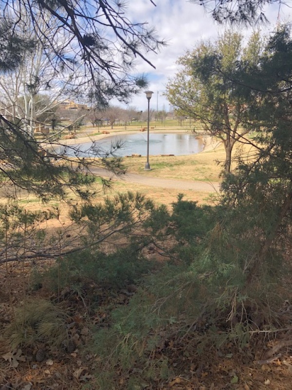
This is the view from the trailhead.
The climb is a gentle class 1- but there are some obstacles to watch out for.
One of the tricky areas on the ascent.
I was in good shape after training all winter so I was able to make it down before sunset but even if I didn't, the trail is well lit.
Trail is well lit.
Like I said, I trained really hard and was already acclimated so I didn't need to but there are some convenient benches on the way up if you need to take a break. Although, in the amount of time it would take to walk over to them and sit down, you could be on the summit.
Benches
Always be sure to bring plenty of water. If you didn't want to hike in all that water, there is a source nearby but accessing it would make the round trip three times longer. Also, if you didn't want to bring all the water purification gear there are lots of buildings nearby that have water fountains but stopping halfway up to go access that water source will make the roundtrip about eight times longer.
Water source
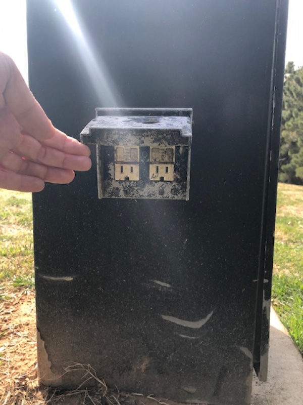
Right next to the summit there's an electrical outlet, so that's convenient.
Electrical outlet near summit
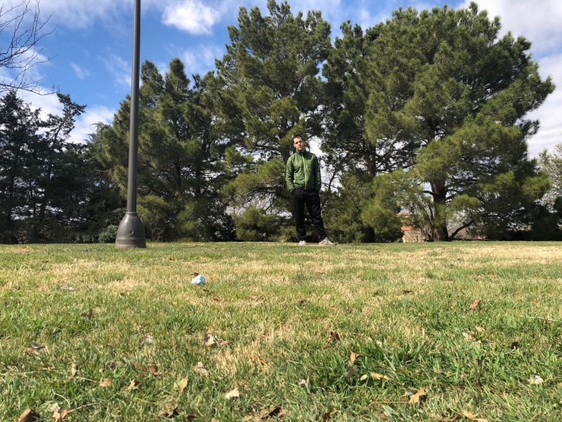
I know everyone always wants to know times so I left the trailhead at 1:17:30. About halfway up I started having doubts but then summit fever took over and I pushed through and summitted at 1:17:50. The view from the top was totally worth it.
Summit photo: I'm appropriately enthused
I should point out that while I had good cell service at the trailhead and on the summit, I didn't check on the way up so it may be spotty in places.
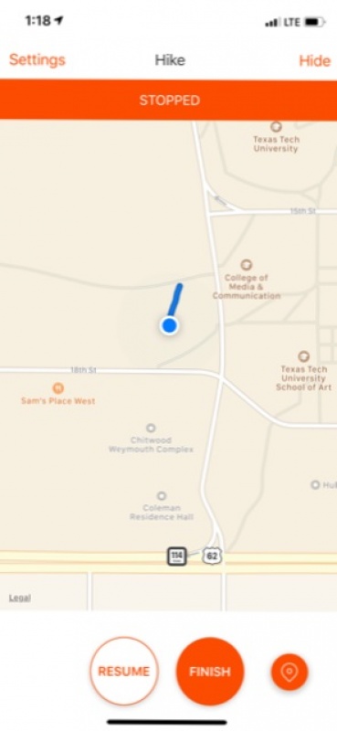
Here's the route.
Strava must have somehow malfunctioned on the way up because it didn't register the climb but I would estimate it's about 0.08 miles roundtrip with a total elevation gain of 12 feet.
Let me know if you have any questions about the climb.
Thumbnails for uploaded photos (click to open slideshow):
Seriously, though, I'm sorry your initial plans got ruined, but man am I glad you channeled your frustration into this! I laughed so hard that I irritated my upstairs neighbor, and since she spent an hour vacuuming last night, I laughed even harder from getting my revenge.
MikefromCraig, I was thinking about this summit, but from an alternate route, perhaps West Slopes. Would you suggest a guide service for this climb? Not from Texas, how is customs getting in and out? Malaria/Altitude/GI issues?
Rick Canter, I would stay away from the north face in the winter as it gets windloaded with snow. Sure, at only a 5% incline it is unlikely to cause a slide but better safe than sorry.
Caution: The information contained in this report may not be accurate and should not be the only resource used in preparation for your climb. Failure to have the necessary experience, physical conditioning, supplies or equipment can result in injury or death. 14ers.com and the author(s) of this report provide no warranties, either express or implied, that the information provided is accurate or reliable. By using the information provided, you agree to indemnify and hold harmless 14ers.com and the report author(s) with respect to any claims and demands against them, including any attorney fees and expenses. Please read the 14ers.com Safety and Disclaimer pages for more information.
Please respect private property: 14ers.com supports the rights of private landowners to determine how and by whom their land will be used. In Colorado, it is your responsibility to determine if land is private and to obtain the appropriate permission before entering the property.

")
")
")
")
")
")
")
")