Mt Elbert - Southeast Ridge Trail (Black Cloud Trailhead)
17 August 2017 (Thursday)
Hike Times: 6:08am - 2:45pm MDT (8h 36min hike duration)
Distance/Elevation: 11.95 miles / 4905 ft (MapMyRun estimates)
Mountain Conditions: Full summer conditions. Dry, with only minor snow patches on the north facing slopes of North Elbert.
Weather Conditions: Dry. Cool. Clear in the morning, increasingly cloudy in the afternoon with isolated showers.
Crowds: Sparse. Encountered only 3-4 groups on the Southeast Ridge Trail. Very busy at the Elbert summit.
Mt Elbert was my first 14er and a life changing experience. Given how much I used this website as a resource leading up to the hike, I can only try to give back to the larger community with this Elbert Trip Report. Thanks to all the contributors on this site.
I was born a flatlander and spent most of my formative years in the Midwest. I think my fondness for hiking is directly linked to the absolute lack of topography of my upbringing. I currently live in Northern Virginia and try to get out to the Blue Ridge (Shenandoah NP) as often as I can. My training regiment leading up to the Elbert hike included six major Appalachian hikes (10-15 miles, 2000-4000 ft) in addition to cycling and running. I also allowed myself six days for altitude acclimation in Colorado and slept two nights in Aspen (8000 ft elevation) before the hike. My overall assessment is that my legs were in sufficient shape to climb 5000 ft, but my lungs were struggling in the 13,000 - 14,433 elevation band.
Elbert was appealing to me as my first hike because it's the highest peak in Colorado and it has lower difficulty ratings than other trails. I chose to hike Elbert from the south, starting at the Black Cloud Trailhead and hiking up the Southeast Ridge trail. This decision was partially out of convenience (I was staying in Aspen and it was a shorter drive), preference (I would rather be hiking on the trail than driving up a dirt road to the East Ridge Trailhead) and challenge (~5000 ft elevation hike from the river valley to the highest peak). In retrospect, the view to the south towards La Plata Peak while hiking was breathtaking and much better than the summit view.
The Black Cloud Trail starts uphill and doesn't really stop. This is typical for the first phase of the hike:

As you start to climb up the hillside, La Plata Peak comes into view and is one of the first peaks to get the Sun's first rays as the sun rises.

There are two stream crossings early in the hike, but they are not difficult and do not require fording. Your shoes should not get wet on this hike!


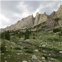
By the second mile, the trees are starting to get a little more sparse and you encounter a relative flat. The trail is still very easy to follow through the landscape.

However, this does not last for long, and you soon find yourself in the leg-burner phase of the hike that I described to myself as the never-ending up. It's a well-trodden hiking trail that looks up to South Elbert peak, but the incline just keeps going at a decent rate and will continue all the way to the first Elbert ridgeline. This is definitely steeper than anything I've encountered in the Appalachians.

Again, the beauty of this hike as you clear the treeline is the gigantic landscape tapestry that opens up to the south. It's classic Sawatch Range scenery. Big, rounded peaks that are dominated by La Plata, but with a relatively dramatic drop into the Lake Creek valley below. In all, about 5000 ft of topography spills out before your eyes.


By about mile 2.75, you have reached the never-ending switchbacks that give your legs the opportunity to climb 1300 feet in a little less than a mile (12,000-13,300 ft elevation). If you started at sunrise, the first rays are finally starting to clear the mountains to your east. Don't forget to apply sunscreen as you are completely exposed above the treeline.

There is a beautiful sense of solitude being the only shadow on the hillside:

Eventually, at long last, you reach the ridgeline. A cairn marks the general change in slope. At this point, the decrease in slope is a welcome change and a great spot to take a break before the next push.

Once you reach the first platform at mile 3.75, Elbert finally comes into view. Your destination is in sight, but you still need to gain another 1000+ feet to reach the summit. You also get the bonus of bagging South Elbert along the way, although with the cost of some elevation loss between the two peaks.

Continue hiking towards your goal. The trail on the ridgeline becomes a little less apparent, but can still be maintained with a good map and some keen eyes. I will admit that this section of the hike was a little deceiving. The slope was more gradual, but this was punctuated by short climbs up rocky mounts that remind you how thin the air is getting. Elbert also slowly approaches during the nearly 2 mile stretch, eventually giving you a sense for how large the pile of rocks that the mountain actually is. [EDIT: I should stress that the ridgeline is quite long and there are not great bail points along most of the ridge. Keep your eyes on the sky and be prepared to turn around if conditions start to deteriorate.]


The last phase of the hike is along the spine of the Elbert massif that will lead you to the summit. It's generally rough stuff, consisting of frost-heaved metamorphic rock talus (cobble to boulder sized). However, the rocks are large enough that there isn't a huge amount of sliding. Some basic scrambling is required and there is no real trail to speak of. Keep pressing as you are getting close to your goal!


The summit is worth the effort. The air is noticeably thinner and you will be happy to know that it will only improve from this point. A clear view of Mount Massive to the north is a highlight.


Clouds were starting to build as the hour approached noon. Isolated rain storms were dumping significant amounts of rain on isolated spots. I still passed two groups on my way down and conditions were not improving. Please consider starting the hike no later than sunrise as it minimizes your chances of inclement weather.

The Western Paintbrush provides a nice shot of color in the Rockies during August and was a good touch.

Elbert is one of those mountains that gets a whole lot of foot traffic, so I don't know how much this report will add to the picture. However, I would only stress that this non-standard path up Elbert may re-invent the mountain and give you a renewed excitement for the Sawatch Range. It was a really satisfying experience and the views were incredible.
I used two camera on this hike (phone and camera), so the order of the thumbnails below is a little screwed up. Phone photos are Picture 1 to the the Yellow Western Paintbrush. Camera photos follow afterwards.
My phone also died on the way down, so my GPX file (below) is missing the last 1.8 miles and 59 minutes of data. I reached my car at 2:45pm MDT.
")
")
")
")
")
")
")
")
")
")
")
")
")
")
")
")
")
")
")
")
")
")
")
")
")
")
")
")
")
")
")
")