| Report Type | Full |
| Peak(s) |
Nevado de Colima - 14000 Volcán ParicutÃn - 10800 |
| Date Posted | 02/11/2019 |
| Modified | 02/12/2019 |
| Date Climbed | 12/08/2018 |
| Author | mtn_nut |
| Volcanoes of Western Mexico |
|---|
|
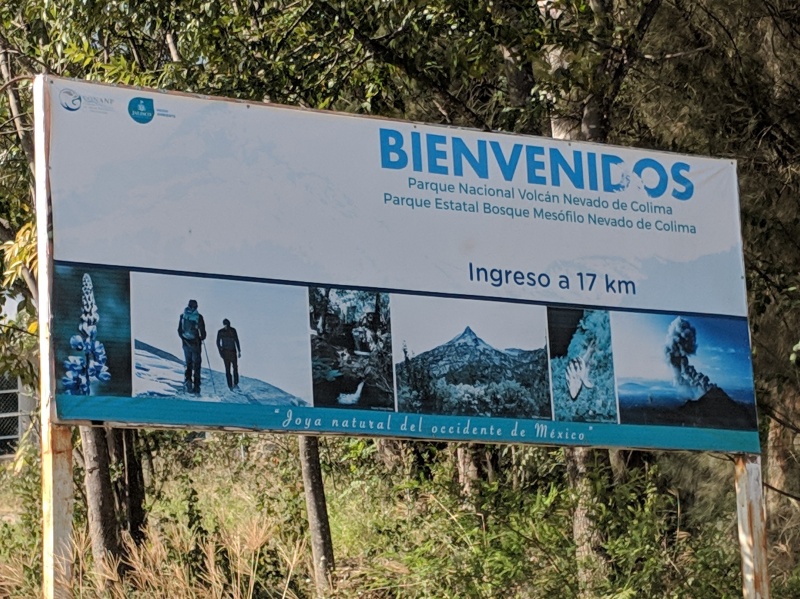
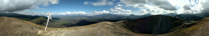
Is it a 14er? Is it a 13er? Either way, Nevado de Colima is really close, and it's definitely another ultra prominent peak, so it has been on my list for a while. I actually planned on climbing it in Nov 2017, but due to a death in the family, that trip was canceled. Then I had another trip tentatively scheduled for New Years 2019, but then that also had to be canned due to some more schedule conflicts. Third time's the charm, and I had a free weekend in December. They do have non-stop flights from Denver to Guadalajara on Volaris, but the flight schedule sucks, leaving Denver mid-Thursday and flying back early Sunday. After a quick search, I found something a little better. American Airlines had a short one stop award flight DEN-PHX-MEX that left late in the evening on Thursday and also had a Sunday night award flight back from Guadalajara (GDL-PHX), but there wasn't enough time to catch the last AA flight from PHX after the flight came through. There were two frontier flights from PHX to DEN, one very late on Sunday, and one early enough Monday morning that I would still allow me to make it to work Monday morning if something delayed my flight into Pheonix. Both Frontier flights happened to be on sale for ~$20 each, so for $40, I had a Sunday night flight plus a Monday backup. I still had to get from Mexico City to Guadalajara on Friday morning, and an early Interjet non-stop flight kept my overnight layover in MEX to a minimum and only cost another $40. It was a bit of a patchwork, but I felt like as long as my first flight from DEN-PHX wasn't delayed, everything else should fall into place. The flights all went off without a hitch, and I even got a decent amount of sleep on the flight from PHX-MEX and at the Mexico City airport at the priority pass lounge (Lounge 19), and another quick nap on the Interjet flight to Guadalajara. I'm pretty fortunate that I can fall asleep just about anywhere with some earplugs and eye covers. We landed in Guadalajara just after sunrise, and since my plans didn't involve climbing much on Friday, I took another nap in the car after picking up my rental VW Tiguan (#1 rule of Mexico, always have something with clearance for the speed bumps). Driving in the areas away from Mexico city was nice, everyone drives more or less normally, and even though I don't like driving toll roads, I paid a few dollars worth of pesos to take the toll highway to Ciudad Guzmán. After a quick stop at a grocery store to pick up some dinner and breakfast items, I headed up towards the mountain, with my goal to camp where I could see Volcán de Colima, and maybe get a photo of some lava glow and enjoy camping under the stars. After a long windy single lane dirt road, I made it to the first gate (19.593068, -103.593439), where I had to pay my obligatory park entrance fee of $34 MXN (about $1.50) and continued up the road. Drove to the second gate (19.581253, -103.610711) which was locked and parked next to a few trucks. At this point, it was getting late in the day, so I packed up my overnight gear and set off up the road. There is a small camping area at turn in the road, a few hundred feet from the gate, with latrines, and from there the road turns to the south towards the main summit. 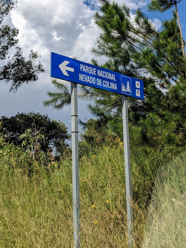
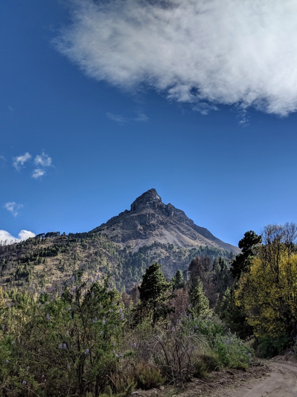
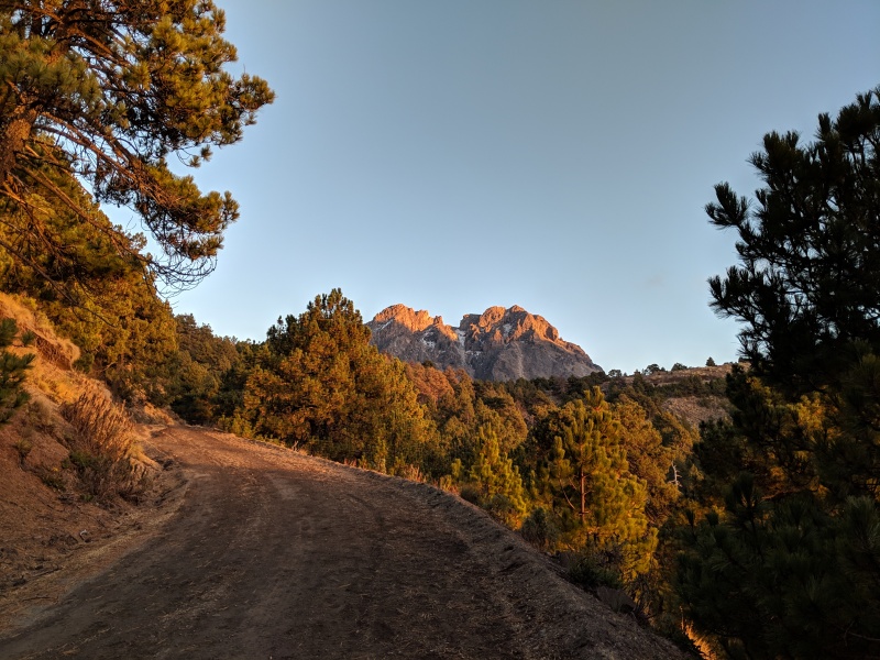
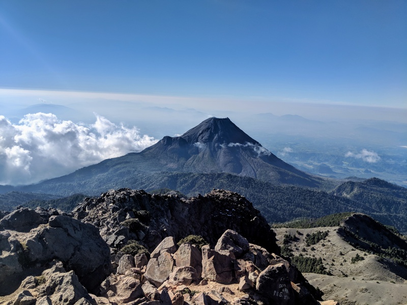
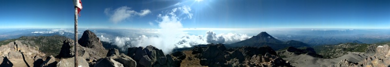
It's an easy well-graded road so it is an easy walk. At the sign for Volcán de Colima overlook (Mirador Volcan Fire on google maps) is where you finally leave the trail, going down 20-30 feet before traversing towards the next saddle between Nevado de Colima and the radio tower covered sub-summit directly above the overlook. At the saddle, the trees ended and I found a nice flat bivy spot that avoided most of the wind. The weather had held out perfectly, and it was a crystal clear night with only a light wind. It was cold at 13k feet, but not cold enough to freeze any of my water. Unfortunately, there was no lava glow that evening off Volcán de Colima, but the stars gave me a good show and I got to test out my new camera a little. Even if there had been some lava glow, any photo would have been terrible because all the lights of the city of Colima were directly behind the volcano. My new camera's lens wasn't really up to the task of taking good star photos like my old Ricoh GRII, so the star shots weren't anything to write home about. The next morning I woke up at sunrise, packed up my camp stuff and hid it in the trees. With only about 1000 vertical feet remaining, it was a quick morning, and the climb was pretty fun with some scrambling and not too much gravel and scree. I summited around 8:30 am local time, took my obligatory summit photos, and enjoyed the solitude. My watch showed an elevation of 14098 feet at the summit, higher than the "official" height of 4260 meters/13976 feet, but then again my Suunto Ambit3 isn't always the most accurate. It seems like there are widely cited elevations, so I'm not really sure if it was another 14er, but it was an enjoyable climb anyways. It was a quick descent down, but I had to make sure to pay attention to my routing since it would be easy to miss the turn from south to northwest. I ran into some others on the descent, all of which were very friendly as we both wished each other luck (Suerte!). Back down at the saddle, I grabbed my gear, and a few locals that spoke English asked me how my night was, saying they always had wanted to come camp out there and thought that was neat. On the road, I ran into a few other Americans, and then made it back to my car by 10:30 am and headed down the road. The most dangerous part of the entire trip was driving down that road, and twice I had to swerve out of the way of a truck barreling up the one lane road on Saturday morning. After making back down to Ciudad Guzmán, I had a choice to make. I could go after another ultra, with the choice of Volcán de Tequila or Cerro Tancítaro, or I could do something a little more touristy. 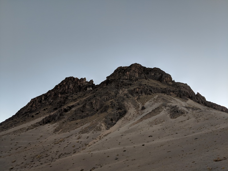
I had read in my guidebook about Volcán Paricutín, which erupted in 1943 out of a farmer's field, and continued erupting until 1952. I actually remember hearing about it when I was a kid, thanks to my mom watching reading rainbow with me. The trip reports for the nearby ultra Cerro Tancítaro left a lot to be desired, as it sounds like a pretty terrible climb and didn't seem too appealing. It was a long drive between Ciudad Guzmán and the town of Angahuan, but I had plenty of time, and the hike the next day looked good as long as I started early enough to get back to Guadalajara that evening. Angahuan ended up being a bad place to try to car camp, as the area is mostly agricultural and rural, and most people were only interested in selling me a horseback tour of the volcano in the morning instead of letting me sleep. After looking at the maps, it looked like there was a road between Zacán and the ruined church of San Juan Parangaricutiro, and sure enough it provided easy access. I parked a half mile away from the church in the middle of a lava field and enjoyed another night under the stars camping. 
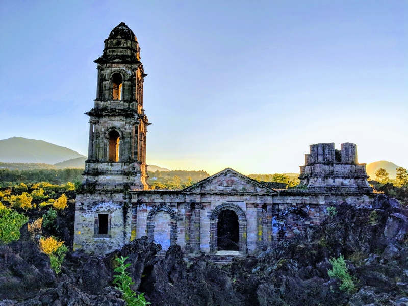
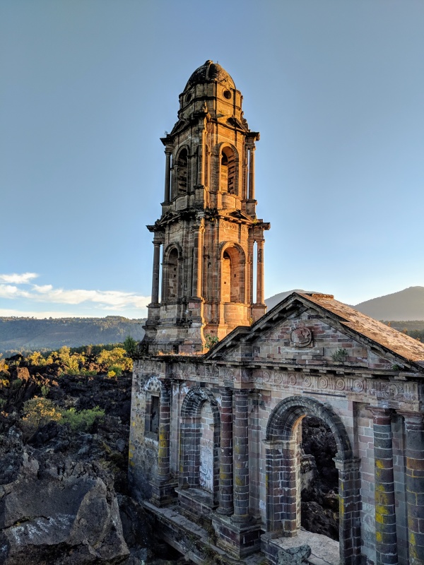
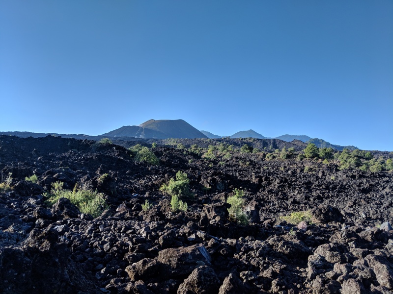
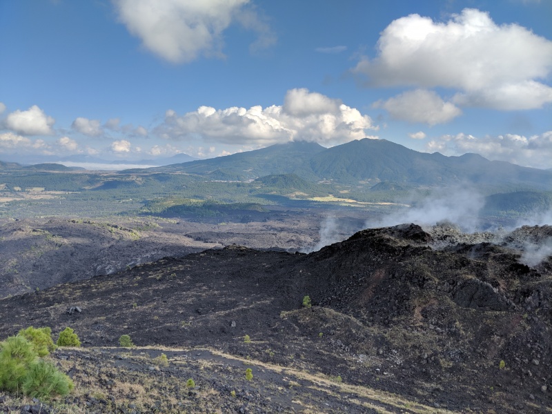
At sunrise, I got up and set off towards the church. Nobody else was up yet, so I had the ruins to myself and after a few photos, I headed up the road a little more towards something referenced as the "white gate" on a trip report I found on peakbagger. Sure enough, there was a large white gate with an opening that allowed a person to fit through, and I headed up the second road till I came to the massive lava field crossing. The lava was quite rough, which gave me plenty of traction but I was careful not to trip since I didn't feel like having to patch myself up. Navigating the field was eased by the white rock markings, but it was still pretty easy to lose the markings as I headed towards the base of the final cinder cone. From the base, it was a quick but steep hike to the edge of the cone, and I finished on the west edge of the cinder cone where there was a cross marking the high point. Retracing my tracks, it was much easier to find the white markers on the descent than the ascent and was able to cut the lava field crossing to around an hour, whereas it took me about an hour and a half on the ascent. After that, I just had to put in a few miles back to the car, which was still sitting along the road where I had left it. The drive back to Guadalajara was unremarkable, as I opted to take the toll road instead of the side highways since it was a long drive back, and the flights home were unremarkable as well, getting into Phoenix early and whizzing past customs in less than 5 minutes (thank you global entry), making it back on my sunday night frontier flight :-) 
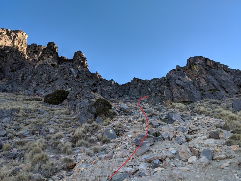
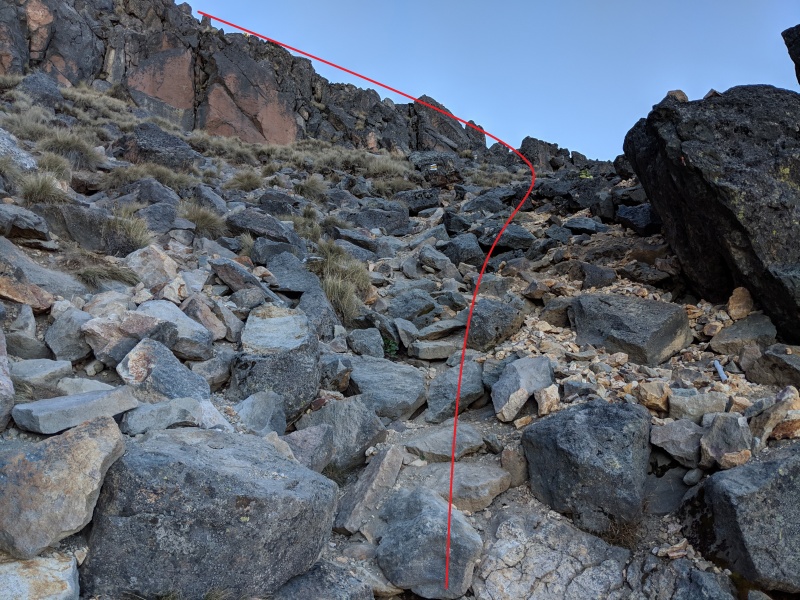
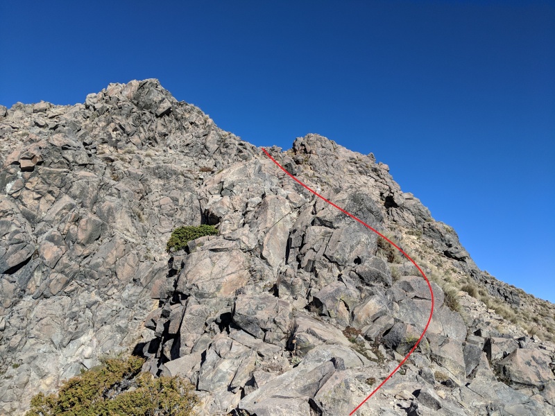
If anyone is wanting more directions up Nevado de Colima, here are some 14ers.com style route photos. 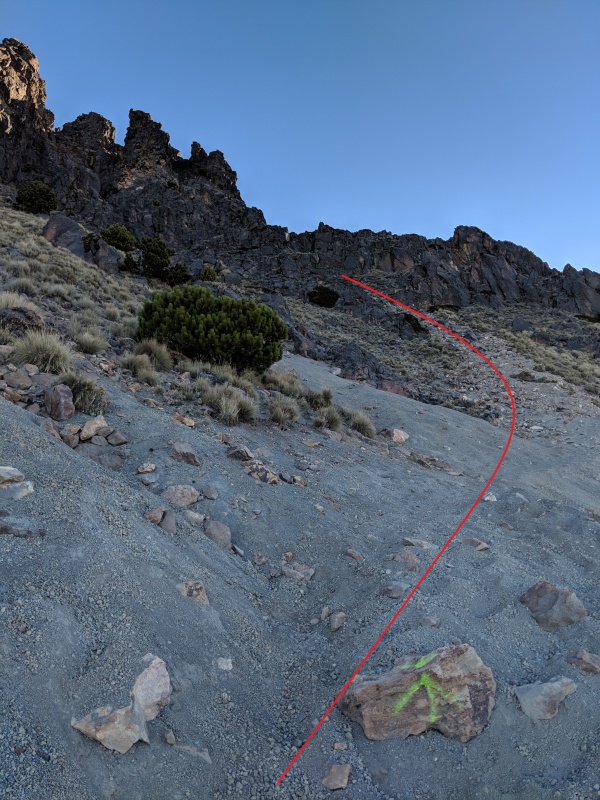
Thumbnails for uploaded photos (click to open slideshow): ")
")
")
")
")
")
")
")
")
")
")
")
")
")
")
")
")
")
|
| Comments or Questions | |||
|---|---|---|---|
|
Caution: The information contained in this report may not be accurate and should not be the only resource used in preparation for your climb. Failure to have the necessary experience, physical conditioning, supplies or equipment can result in injury or death. 14ers.com and the author(s) of this report provide no warranties, either express or implied, that the information provided is accurate or reliable. By using the information provided, you agree to indemnify and hold harmless 14ers.com and the report author(s) with respect to any claims and demands against them, including any attorney fees and expenses. Please read the 14ers.com Safety and Disclaimer pages for more information.
Please respect private property: 14ers.com supports the rights of private landowners to determine how and by whom their land will be used. In Colorado, it is your responsibility to determine if land is private and to obtain the appropriate permission before entering the property.

