Download Agreement, Release, and Acknowledgement of Risk:
You (the person requesting this file download) fully understand mountain climbing ("Activity") involves risks and dangers of serious bodily injury, including permanent disability, paralysis, and death ("Risks") and you fully accept and assume all such risks and all responsibility for losses, costs, and damages you incur as a result of your participation in this Activity.
You acknowledge that information in the file you have chosen to download may not be accurate and may contain errors. You agree to assume all risks when using this information and agree to release and discharge 14ers.com, 14ers Inc. and the author(s) of such information (collectively, the "Released Parties").
You hereby discharge the Released Parties from all damages, actions, claims and liabilities of any nature, specifically including, but not limited to, damages, actions, claims and liabilities arising from or related to the negligence of the Released Parties. You further agree to indemnify, hold harmless and defend 14ers.com, 14ers Inc. and each of the other Released Parties from and against any loss, damage, liability and expense, including costs and attorney fees, incurred by 14ers.com, 14ers Inc. or any of the other Released Parties as a result of you using information provided on the 14ers.com or 14ers Inc. websites.
You have read this agreement, fully understand its terms and intend it to be a complete and unconditional release of all liability to the greatest extent allowed by law and agree that if any portion of this agreement is held to be invalid the balance, notwithstanding, shall continue in full force and effect.
By clicking "OK" you agree to these terms. If you DO NOT agree, click "Cancel"...
January 4-5, 2019 ~20.4 Miles, ~7,100 Gain TH: Snowmass Creek (winter closure, 2WD)
A long stretch of stabilizing snow with good weather...it looked like a good time to attempt Capitol. It's been 17 years since my last visit. Admittedly, the climbing at Shelf Road looked even better but I needed a good slog. I reached out to Natalie, who invited Matt, to team up for an adventurous outing on this fine peak. Although the Avalanche conditions were moderate, I'm never one to fully trust the CAIC forecast due to such variance even within their forecasting zones. I've released avalanches – though small – in forecasted “green” conditions on unexpected aspects. I have also otherwise observed better than predicted conditions in moderate/considerable conditions; all of which, were approached with caution.
Arriving just before 9AM at the winter Snowmass Creek road closure on Jan 4th, we met up Matt and Natalie. We finished last-minute packing and started booting up the road. Although not mandatory, we donned our snowshoes just after the first gate past the start of the summer trail. Following a good trench, we quickly reached the trail junction for West Snowmass Creek.
That's one way to cross the river, burrr
Blindly following the trench up West Snowmass Creek we quickly veered off the summer trail, which I was hesitant. Continuing, the trench had some creative route finding and bushwhacking where we found a party of three making their way through some nasty bushes. We took the lead and corrected course and arrived quickly back on trail. Remnants of an old trench then guided us upward as that trench dissipated near 9,400.
Near 9,600, the snow became deep with unconsolidated powder. This is where the hellacious trail breaking commenced. We took turns breaking trail as our progress slowed immensely. Usually, pockets of firm snow could be found but today that wasn’t the case. Ah, a real fine leg burning workout of a normal winter snow-pack. Near 10,000 feet we decided to stay on the left side of the creek and snake our way up the valley. The snow deepened and remained unconsolidated. It. Did. Not. Let. Up.
Trenching (Photo by Natalie)
Not digging this trenching (Photo by Natalie)Lovely POW (Photo by Natalie)
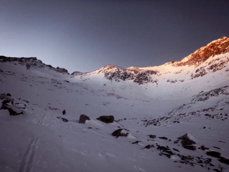
Just before full darkness set in, we arrived at camp near 11,340 after 8 hours of trail breaking. Matt earned MVP of the day with more than his fair share of trail breaking. I'm bummed I didn't have my AT ski setup but due to a house fire in October, that wasn't an option as it destroyed a large portion of my outdoor gear. The tradition of boiling water and other winter busy work ensued.
Making our way to camp just before darkness
A tropical vacation? With fine dining?
Lovely camp
Alarms went off and we progressed upward towards Moon Lake at 5:30 AM. A slight navigational error on my part due to an old track from 5 years ago when I did Clark was promptly corrected. It would have probably worked but it's good I had teammates to keep me in check.
Who loves alarm clocks in the winter?
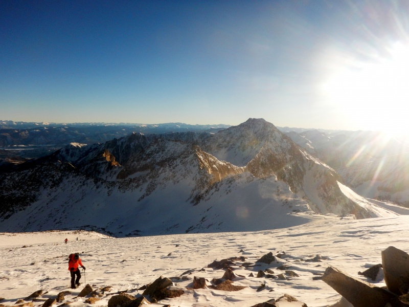
Slogging upward, the snow quality didn't improve and more powder trail breaking commenced. We kept our snowshoes on – Matt and Natalie their skis – until just below K2 at 13,600. Now that's a full value slog. After a short break and a stashing of snowshoes, we arrived on the top of K2 just before 9 AM. At this point, we had split into two separate teams.
Working our way above Moon Lake.
Alpenglow
Working our way towards K2 (out of sight)
Working towards K2
First view of the mountain.
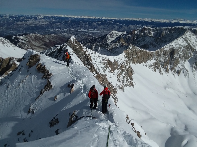
David and I started our down-climb off K2 and quickly reached the Knife Edge. The snow wasn't inspiring. No rock was showing and there were small cornices going both ways off the ridge! We decided to simul-climb this section due to the poor quality snow. Punching through, and sluffing off snow from some rock, we slowly made progress towards the summit. Before reaching the crux, I had to maneuver across a deep snow loaded slope (no signed of avy unstability) and proceeded up the fairly steep snow slope. In hindsight I could have stayed on the ridge for a little easier climbing, which we down-climbed on our return.
Climbing up K2
Down-climbing K2 (tilted by accident – not that extreme)
Matt starting the Knife Edge (Photo by Natalie)
Working across the Knife Edge. Photo taken from K2 by Natalie
Starting across the Knife Edge (Photo by David)
(Photo by Natalie)
(Photo by Natalie)
Snowy Knife Edge (Photo by Natalie)
Matt stating up towards the base of the crux headwall (Photo by Natalie)
(Photo by Natalie)
Once at the crux step, we opted for the bypass. We created a belay anchor and I started across the steepening snow slope. About halfway across, I hit a pocket between the rock and snow and sunk down to my shoulders which isn't the most inspiring on steep snow. Cursing, I managed to finagle my way out of the hole.
Tiredly, I made it across the slope to the “rock” rib that allowed me access up towards the ridge. This was the technical portion of the climb. I proceeded upward in soft snow, digging down to the rock looking for decent holds to climb on. At one point, I was stomach deep in snow and while I was dry-tooling, a grapefruit sized rock dislocated knocking my balance off. I continued to wallow painfully.
Fighting upward, I reached “The Horn” and set up a belay for David. From The Horn, it was a short steep snow scramble to the ridge. A small notch in the ridge provided perhaps one of the more exciting portions of the traverse which was a step across with horrid snow, steep on both sides, to an awkward mantle on a slab with sluffing snow. With better consolidated snow, this would have been a non-event.
Looking down at the crux traverse
Looking down the crux up-climb.
Before reaching the final dihedral gaining the summit ridge, Capitol gave us one more energy consuming battle. Now, neck deep in steep snow at a point, trying to claw upward, I made zero progress. A funky dry-tooling move with some awkward gymnastics allowed me to gain traction to reach the final dihedral. Fortunately, the final dihedral (class 4? was expecting mid 5th from prior reports) went without a hitch. David and I reached the summit just before 11:30 AM.
Gymnastic-Dry-Tool Maneuver™
Just before the gymnastics and summit Dihedral (Photo by David)
Summit views (Photo by David)
Summit views (Photo by David)
The wind had started to pick up so we started back towards K2. We were able to down-climb the ridge fairly easily to The Horn were I added webbing for a rappel anchor. With our 30M rope we were able to rappel back to our traverse with about 5-10 feet of down-climbing after getting off rope. Some may want a longer rope and a 40M rope would suffice.)
The Horn Rappel
Descending the final summit ridge (Photo by Matt)
(Photo by Natalie)
Now back on easier terrain, we reached Natalie and Matt who weren't stoked on the snow conditions, rightfully so, and decided to bail before climbing the crux. David and I passed and made better progress back across to K2 now that the trail had been blazed. A bit tired, the scramble back up K2, seemed harder than it should have. We arrived back at the top of K2 at 1 PM, ate a quick snack and limped back into camp around 2:30 PM.
David and I took a break in camp, ate some dinner, boiled more water and waited for the second party to return back to camp which they did safely. To avoid an impending forecasted storm and an awful drive back on I-70 to Denver on Sunday, we decided to pack up camp and slog back to the car. We left camp around 4:30 PM and slogged. And slogged. And slogged. Exhausted, we arrived back at the car at 8:00 PM and arrived home just before midnight. It's amazing how much faster travel goes when a trench is in place and a drive without Sunday, snowy traffic.
My GPS Tracks on Google Maps (made from a .GPX file upload):
That would be too much work for this old guy. Now if someone could heli-drop me on K2 (or the summit) so I could ski that beast, I'd be a happy camper.
That is hardcore. I saw a photo by Natalie on IG and wondered when the TR would show. A tremendous task and accomplishment for all involved. Tip of the hat.
The slog to end all slogs! Thanks Derek, Matt, and Natalie for a great trip! Think I'll seek out some sunny relaxing sport climbing and camping for my next outing....
Huge congrats! I'm wondering why the route from Snowmass TH vs standard route? Is it shorter due to the standard approach road being closed much further down? OR was it in lieu of avy reasons? Been looking at doing this and curious of your TH selection. Thanks and congrats again.
Sounds like an excellent suffer fest ;). Great TR!
I'm looking at making an attempt this weekend, any advice on what protection you'd bring if you did it again?
Thanks
Alex
Caution: The information contained in this report may not be accurate and should not be the only resource used in preparation for your climb. Failure to have the necessary experience, physical conditioning, supplies or equipment can result in injury or death. 14ers.com and the author(s) of this report provide no warranties, either express or implied, that the information provided is accurate or reliable. By using the information provided, you agree to indemnify and hold harmless 14ers.com and the report author(s) with respect to any claims and demands against them, including any attorney fees and expenses. Please read the 14ers.com Safety and Disclaimer pages for more information.
Please respect private property: 14ers.com supports the rights of private landowners to determine how and by whom their land will be used. In Colorado, it is your responsibility to determine if land is private and to obtain the appropriate permission before entering the property.


")
")
")
")
")
")
")
")
")
")
")
")
")
")
")
")
")
")
")
")
")
")
")
")
")
")
")
")
")
")
")
")
")
")
")
")
")
")
")
")


