Download Agreement, Release, and Acknowledgement of Risk:
You (the person requesting this file download) fully understand mountain climbing ("Activity") involves risks and dangers of serious bodily injury, including permanent disability, paralysis, and death ("Risks") and you fully accept and assume all such risks and all responsibility for losses, costs, and damages you incur as a result of your participation in this Activity.
You acknowledge that information in the file you have chosen to download may not be accurate and may contain errors. You agree to assume all risks when using this information and agree to release and discharge 14ers.com, 14ers Inc. and the author(s) of such information (collectively, the "Released Parties").
You hereby discharge the Released Parties from all damages, actions, claims and liabilities of any nature, specifically including, but not limited to, damages, actions, claims and liabilities arising from or related to the negligence of the Released Parties. You further agree to indemnify, hold harmless and defend 14ers.com, 14ers Inc. and each of the other Released Parties from and against any loss, damage, liability and expense, including costs and attorney fees, incurred by 14ers.com, 14ers Inc. or any of the other Released Parties as a result of you using information provided on the 14ers.com or 14ers Inc. websites.
You have read this agreement, fully understand its terms and intend it to be a complete and unconditional release of all liability to the greatest extent allowed by law and agree that if any portion of this agreement is held to be invalid the balance, notwithstanding, shall continue in full force and effect.
By clicking "OK" you agree to these terms. If you DO NOT agree, click "Cancel"...
I know others have day tripped North Massive & Massive in winter, but most of the winter trip reports I saw were either not day trips or indicated going up and down the east ridge from Massive's main summit, doing the traverse between the peaks twice. I did a practice run of the route I'll describe on November 30, 2017 to see if I thought it would go in a day in winter; it went really well yesterday, so I thought I'd go ahead and write it up in case a trip report is helpful to someone down the road.
The Hike - January 2, 2019
Stats: Solo Mileage - my InReach says 13.2 miles Vertical ~5,000' Round Trip Time - 12:23 car to car from the Fish Hatchery
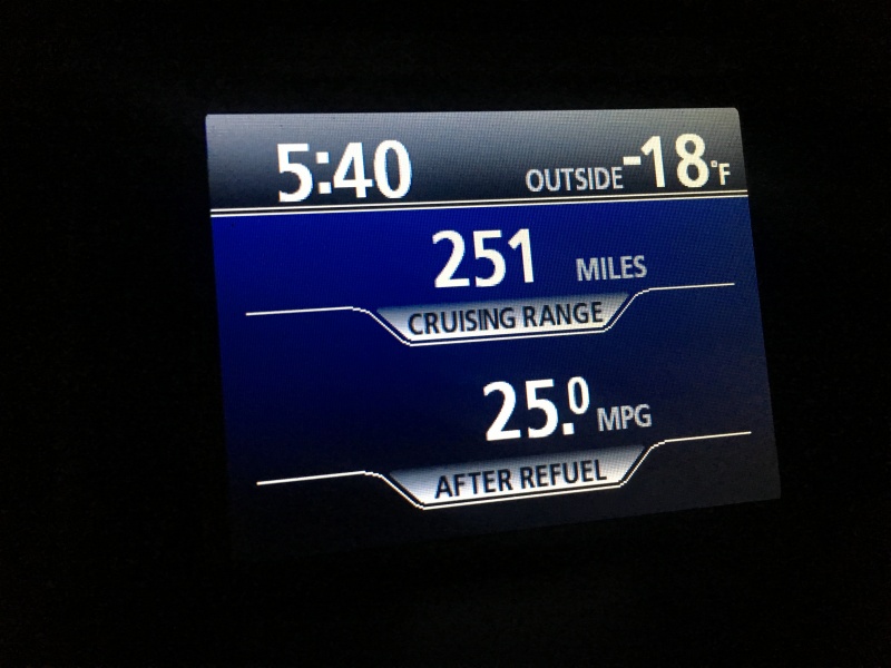
I left my house at 3:30 AM and drove to the Leadville Fish Hatchery trailhead. It was a little brisk as I pulled in at 5:40 AM. I geared up and started walking at 6:00 AM on the dot.
Ouch
The forecast called for a cold, but clear and most importantly calm day (wind forecast was 5-10 mph - it ended up being 0-5 mph - basically non-existent). There was a well established trench up past where the Highline Trail crosses the Colorado Trail, but the trench ended in the clearing around 11,400'.
Thanks pre-trenchers!
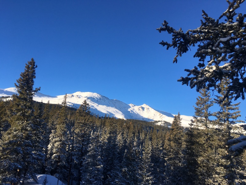
View from the clearing - Main summit in center; North Massive is the pointy one on the right with the ascent ridge coming down from it.
I knew I wanted to do North Massive first so I could come down Mt. Massive's east ridge route and end up back at this clearing. I had bolted on the tails for my snowshoes to give myself a bit more flotation knowing that I was solo and that it was unlikely that anyone had been up North Massive this winter before me. That was a good call. I left the clearing and aimed northwest towards the east ridge that provides easy passage to North Massive. It is not easy getting there though with no trench. I followed my track from November of 2017 and gradually got to the area below the ridge.
Tough trenching through the trees.
More trenching potential.
Continuing to trench and keep aiming for the North Massive ridge.
Finally getting closer to the North Massive east ridge.
There is a frozen lake on the right below the trees. I walked around the right hand side of it, still making my way towards the ridge.
Beyond the lake, it's time to decide how to gain the ridge.
I didn't love the look of getting to the ridge crest in very many places. Even though the avalanche danger was only at yellow, I didn't feel like taking my chances and going up anything remotely suspect. I saw a rocky area on the ridge a little higher up that looked like it would provide safe passage and made my way towards that.
I aimed for the rocky, dry-looking section in the center of the photo as everything else looked quite loaded.
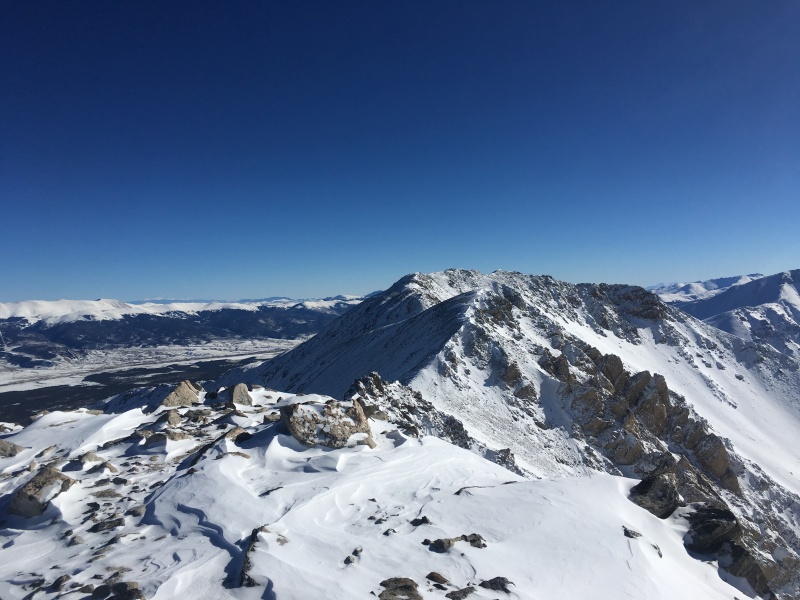
Once on the ridge, I aimed for the right hand of the dual spines on the ridge and hung pretty close to that for the duration of the ridge. The summit of North Massive is directly above that right hand spine.
Note the two spines on the ridge. I went up the right hand side. It's easier than the left hand side and takes you to the actual summit.
Looking back down the North Massive east ridge.
It had taken me 6:52 to get to the summit of North Massive, 52 minutes longer than my 11/2017 dry run, but I was still pleased due to more trenching work this time.
Looking out at the Elks from North Massive.
Looking across at Massive Green & Massive from North Massive.
The descent off of North Massive can be a touch tricky. I switched from snowshoes over to crampons. My axe never came out, but it was with me in case needed. I went over to the false summit, then descended from there, initially taking a scrambly path down, but one that cliffed out slightly more than I was comfortable with on a winter solo. I backtracked and found an easier and safer path down by going farther east and coming back around to the south on a snowy ramp.
My initial descent route that cliffed out.
Looking back at North Massive. I ended up descending farther to the east (right) and traversing down the gentle snowy area with the rock rib in the middle.
Once down at the saddle, I worked my way up some snow on the east side of the ridge to regain the ridge crest. Once back on the ridge crest, large blocks prevent you from staying on the ridge crest. I took the advice of a friendly goat who was kind enough to leave me his tracks and dropped a few feet down the right hand (west) side of the ridge crest where there were a few exposed Class 2+ moves to get back to the ridge crest. Once that was done, the rest of the ridge was a breeze.
Gentle ridge after the goat-advice section that leads to the summit of Massive Green.
Looking back at North Massive with all of the trickier spots in the rear view mirror.
The drop to the saddle between Massive Green and the true summit is nothing and the climb up to the true summit goes quickly from there. After having taken a leisurely snack break, snapped lots of photos, had to backtrack once on the North Massive downclimb, etc., I was on top of Massive Green at 8:28 elapsed time and the true summit at 8:59 elapsed time. Since it was about 3:00 PM and I was a long way from my car, I didn't stay on top long. The Mt Massive east ridge route comes directly up to Massive's true summit, so I just headed straight down its east ridge.
Looking down at the Mt. Massive east ridge from the summit.
I flew down 1,700 vertical feet in the first hour after leaving the summit, but still wanted to be back down in the trees on my original path before dark. The upper part of the descent ridge is easy. The slightly more difficult sections (Class 2+ max if you take your time to find the path of least resistance) are down as you curve back left (north) with the ridge.
Cruising down the ridge trying to beat the darkness.
A key landmark on the descent is this prominent rocky point in the trees shown by the arrow. When you come down off the ridge and prepare to head into the trees, you want to aim for that rocky outcropping and end up on the left (north) side of it.
Look for the rocky outcropping on the way down to get you to the right point in the trees.
Around this area, I found an old set of ski tracks that I followed from the north side of the rocky outcropping that took me the rest of the way back to where I ventured off the established track and trenched over to North Massive.
The rocky outcropping is on my right as the alpenglow lights up the Mosquito range to the east.
Once I was back at the clearing where I had broken off for North Massive, I cruised down the rest of the well-established approach trench. It was pretty close to a new moon last night, so I had to break the headlamp out for the last hour or so, but was back at my car at 6:23 PM. I didn't see another soul all day until I was nearly back down to the Fish Hatchery when a cross country skier (also with headlamp) zipped past me. After a quick dinner at Subway in Leadville, I headed for home and was there before 9:00 PM. Nice little winter solo day trip.
Thanks for reading and I hope this is helpful.
My GPS Tracks on Google Maps (made from a .GPX file upload):
Thanks for sharing and congrats on completing this loop. I looked at this this morning (while driving to work) thinking where the route would go. Perfect weather....
mountainute
It was a cold one alright! My thermometer registered -25 this same morning a bit further south at Elbert. Nice work on this, methinks your trench will see some refurbishment soon...
Had you on my list for these this season, but then I got distracted and never reached out! Nice job, Brad. I may copy this trip later in the year.
Caution: The information contained in this report may not be accurate and should not be the only resource used in preparation for your climb. Failure to have the necessary experience, physical conditioning, supplies or equipment can result in injury or death. 14ers.com and the author(s) of this report provide no warranties, either express or implied, that the information provided is accurate or reliable. By using the information provided, you agree to indemnify and hold harmless 14ers.com and the report author(s) with respect to any claims and demands against them, including any attorney fees and expenses. Please read the 14ers.com Safety and Disclaimer pages for more information.
Please respect private property: 14ers.com supports the rights of private landowners to determine how and by whom their land will be used. In Colorado, it is your responsibility to determine if land is private and to obtain the appropriate permission before entering the property.


")
")
")
")
")
")
")
")
")
")
")
")
")
")
")
")
")
")
")
")
")
")
")
")


