Download Agreement, Release, and Acknowledgement of Risk:
You (the person requesting this file download) fully understand mountain climbing ("Activity") involves risks and dangers of serious bodily injury, including permanent disability, paralysis, and death ("Risks") and you fully accept and assume all such risks and all responsibility for losses, costs, and damages you incur as a result of your participation in this Activity.
You acknowledge that information in the file you have chosen to download may not be accurate and may contain errors. You agree to assume all risks when using this information and agree to release and discharge 14ers.com, 14ers Inc. and the author(s) of such information (collectively, the "Released Parties").
You hereby discharge the Released Parties from all damages, actions, claims and liabilities of any nature, specifically including, but not limited to, damages, actions, claims and liabilities arising from or related to the negligence of the Released Parties. You further agree to indemnify, hold harmless and defend 14ers.com, 14ers Inc. and each of the other Released Parties from and against any loss, damage, liability and expense, including costs and attorney fees, incurred by 14ers.com, 14ers Inc. or any of the other Released Parties as a result of you using information provided on the 14ers.com or 14ers Inc. websites.
You have read this agreement, fully understand its terms and intend it to be a complete and unconditional release of all liability to the greatest extent allowed by law and agree that if any portion of this agreement is held to be invalid the balance, notwithstanding, shall continue in full force and effect.
By clicking "OK" you agree to these terms. If you DO NOT agree, click "Cancel"...
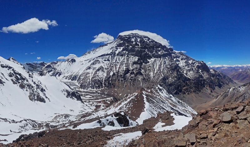
Cerro Aconcagua, or Mount Aconcagua, is the highest peak of the Andes at 22,841 feet above sea level. Not only that, it is the highest peak of the entire Americas, the second most prominent peak in the world, and the highest peak in the Southern and Western Hemispheres of Earth.
My college runs on the quarter system, so I have a 6-week break from Thanksgiving to New Years. Wanting to step it up a notch from last year's trip to Izta and Orizaba, I set the goal of a 6000-meter peak in the Andes. I made plans for various mountains, rejecting each in turn for some combination of logistics, difficulty, and aesthetics. Originally, I shied away from Aconcagua due to stories of crowds, dirty campsites, and ridiculous regulations. Despite these issues, though, itis the highest peak in the region, which attracted my peakbagger mind.
So, long after the Copa Airline tickets were booked, as my term rolled to a close, I settled on a plan to make an unguided expedition to Aconcagua with my parents, who decided to join in the fun of slogging up the world's highest dirt mound.
It's an attractive dirt mound though, I think.
The Objective
Logistics:
After flying into Mendoza, we wasted a day chasing incorrect information around the overcrowded and confusing Argentine city. Specifically, the park headquarters, where permits are issued, had moved effective this year, so unguided groups like our family were following old information from online and from suddenly outdated guidebooks. Different officials, locals, and websites sent us to dozens of different locations, none of which housed the park headquarters. After much ado and some weird phone calls, we finally got the logistics figured out for the next day.
In the end, the logistics of getting a permit looked like this: (1) Fill out a lengthy form online at www.aconcagua.mendoza.gov.ar for each person. (2) Go the the "Ciber Oraculo" gamer haven / computer shop to access a cheap printer and get physical copies of our permit application along with a bar-code sheet for the payment. (3) Go to a "Cambio" (money changer) to convert cash US dollars into the correct amount of Argentine pesos. (4) Find an open "Pago Facil" (Easy Pay--Argentine street version of PayPal) and pay the previously printed bar-code sheet with the pesos. (5) Go to the Aconcagua Provincial Park headquarters in a small building near the entrance to San Martin Park and hand over the payment confirmation sheet along with our applications. (6) Wait for the officials there to give us our climbing permits.
All in all, it's a rather large amount of unnecessary bureaucracy just to go for a hike.
That evening, we drove a couple hours to Penitentes, a tiny ski town near the Aconcagua trailhead, where we stayed in the Hotel Ayelen. Next door, we arranged for the local company Grajales to transport 4 duffels of gear to basecamp via mule.
Clouds hung low over the mountains, it rained heavily at times throughout the evening and night, and the weather forecasts called for a significant amount of snow in the mountains. Spirits were low as we headed into the Park wearing our warm winter clothes--typically, this lower section of the trek can be done in shorts and a t-shirt.
Day 1: December 4 / Trek to Confluencia
After about 4 miles of hiking through a snowstorm, we arrived at Confluencia, the first night's camp around 11,200 ft. The park rangers (called Guardaparque) were freaked out because we arrived in the middle of heavy snowstorm without wearing coats--they didn't understand that it was hot hiking uphill! After a lot of convincing in Spanish, they decided that maybe we could survive the snowstorm, and they allowed us to pitch our Trango 3 tent in the area of camp near Grajales. As our mule providers, Grajales would also provide us with bathroom services and free drinking water in Confluencia and basecamp.
Our tent at Confluencia - Snowy!
The officials and guides at Confluencia told us that the snowstorm was basically unprecedented for this time of the season--typical conditions would be dry, sunny, and hot. Instead, it snowed 6 to 8 inches with temperatures well below freezing. At one point we were told that no one would be allowed to proceed up the valley the next day; luckily this was not true.
After cooking dinner, we went to our appointment with the local Argentinian medic who has to sign off that we were fit to continue. It turns out, climbing Aconcagua is half about negotiating the absurd Argentinian bureaucracy! How many other mountains does the government force you to check in with doctors while camping? Ridiculous! Since the altitude was only 11,200 ft., we of course passed with fine medical results (pulse-ox and blood pressure).
Typically, guided groups are required to spend two nights here with a daytrip to Plaza Francia around 13,000 ft. However, we eventually convinced the Guardaparque that we didn't need to do this, and made plans to leave the next morning. Grajales informed us that because of the snow, the mules would be delayed a day, but we had enough gear to last a day or two anyway, so when the snow stopped falling in the evening, we finalized our plan to leave the next morning.
Confluencia from a nearby hill
Day 2: December 5 / Trek to Plaza de Mulas
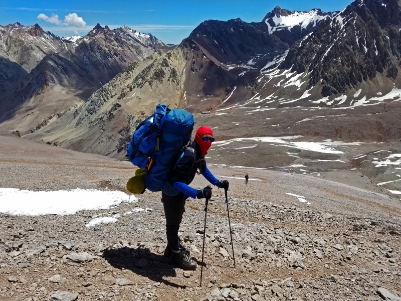
We woke to broken clouds, with the first patches of blue sky we had seen since entering the Park. By now we had made friends with one of the Guardaparque and he wished us well as we started hiking. My mountaineering boots were packed in the mule duffels, and I hiked in leather 3-season hiking boots, which were frozen completely solid from the cold, snowy night. Our approach was rapidly becoming more extreme than expected!
Morning at Confluencia
The trail was snowy but not too deep, and as the clouds cleared, the views became stunning. The previous day's snow was actually a blessing as it made the whole trek much more beautiful. The towering peaks, instead of looking like rubble heaps, shone like white gold under the azure sky.
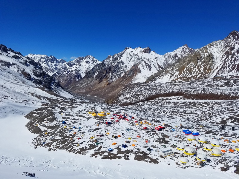
From Confluencia, the trail crosses a second bridge and heads into the massive, flat-bottomed Horcones River valley. The trail runs another 11 miles up the valley from Confluencia to Plaza de Mulas, the metropolitan tent city that serves as basecamp for Aconcagua's normal route.
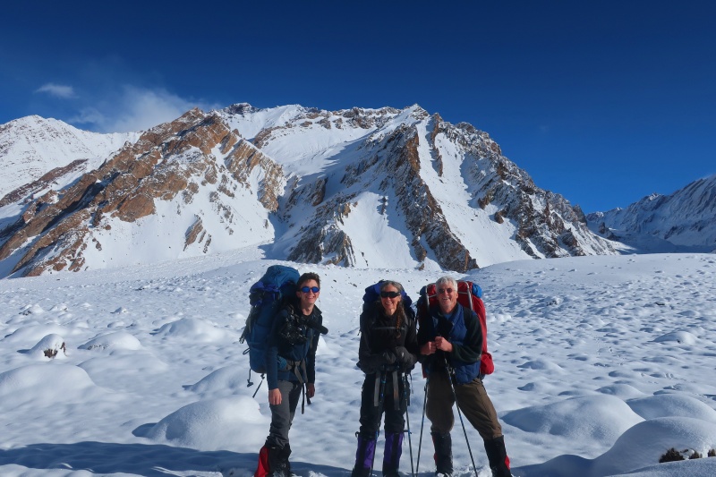
Our family in front of Cerro Mirador, an 18,000-foot peak
The trek was beautiful but relentless, as we hiked for hours up the flat valley alongside the river. The sun was remarkably intense, and despite wearing sunscreen, we would end up with serious sunburns from this day.
Every mile, the distant peaks became a little closer, and as the hours ticked by, we marked off landmarks. There are two large rocks, "Roca Grande y Colorada" (the Big Red Rock) and "Piedra Ibanez" (Ibanez Rock) which offer wind breaks for snack stops, but between these, the valley is exposed and harsh, with few signs of life or shelter in the desolate floodplain.
The massive peak on the left is Cerro Tolosa, a very prominent and difficult-looking massif, and the distant diamond-shaped peak is Cerro de los Dedos (Mount of the Fingers, due to its spires).
Hiking up the Horcones Valley
Toward the afternoon, the sky clouded again, and snow began to fly as we scaled the final, steep 800-foot headwall to basecamp at 14,300 ft. We set up the tent in about 10 inches of fresh, powdery snow.
By sunset, the day's snowstorm had passed through, leaving another inch or two and making Aconcagua's west face look more dramatic than normal.
Aconcagua looms above Plaza de Mulas with fresh snow
Day 3: December 6 / Rest Day in Basecamp
With the fresh snow on the mountain, everything was more difficult than normal, from cooking to hiking. Combined with being tired from the previous day's long uphill hike, we decided to take a rest day in basecamp to sort gear. Around midday, the Grajales mules arrived, bringing our duffels. We set up a second tent, our usual 3-season backpacking tent, to use as a gear tent.
I discovered that the previous day's extreme sun exposure had left my face extremely sunburned--I was blistered and oozing all over my face, which was bright red and hurt to touch. My dad's face was swollen from the sun, while my mom had escaped with more mild burns.
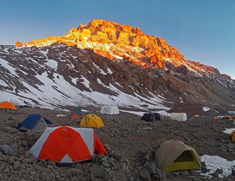
Once again, an evening snow storm put a damper on our spirits and another inch of snow on the mountain.
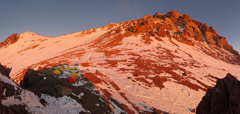
Unsettled weather and colorful tents at basecamp
Day 4: December 7 / Carry to Camp 1 (Canada)
The next day, the weather was clear and sunny in the morning. Every moment I was in the sun, I wore a balaclava to protect my burned face from further damage.
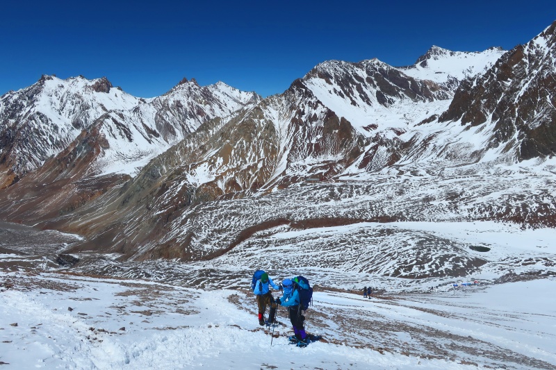
We decided to carry gear up to Camp 1, at 16,600 feet elevation, only a short hike of less than 2 miles from basecamp. The typically dry trail was invisible under fair amount of snow, giving the hike a mountaineering feel as we wore crampons for most of the distance. From Plaza de Mulas, the route climbs up some steep switchbacks and traverses cliff tops on the way to Conway Rocks, a landmark geologic formation about halfway between basecamp and camp 1. These rocks, at elevation 15,600 ft., offer a common place to get out of the wind for a quick break before continuing onto the exposed slopes above.
Basecamp as seen from the first part of the route up
The peaks of the upper Horcones cirque stood out like snowy sentinels all around. Cerro Los Dedos is the peak on the far left here, while Cerro Bonete is the snowy ridge-like summit on the far right.
Climbing around 15,000 feet
Above Conway Rocks, the trail cuts across a steep slope below some cliffs. Eventually, climbers wrap around the left of these cliffs and climb to Plaza Canada, which sits on top of these same cliffs. After a short, steeper snow climb, we topped out at Plaza Canada at 16,600 feet, or 5,050 meters. This location offers a compact area of flat ground with a number of established tent sites. We picked the most sheltered one and cached some gear (mainly a tent, food, and fuel) in a duffel with rocks piled on top.
The edge of the flat area is defined by some jagged rocks which drop off into cliffs. I climbed up onto one of these rock pinnacles to enjoy the view a couple thousand feet down towards basecamp.
After caching our gear, we returned to basecamp. Once again, the evening saw some new snow showers.
Scrambling around Plaza Canada
Day 5: December 8 / Rest day in Basecamp
Extremely high winds up on the mountain encouraged us to take another rest day in basecamp. Besides, my entire face was now unbelievably uncomfortable, as my sunburn had left my whole face scabbed over with lizard-like tough, tight skin. While walking around at basecamp, my mom tripped and hurt her arm; after returning to the United States we found out it was broken! She managed to heroically continue the climb anyway, one-armed.
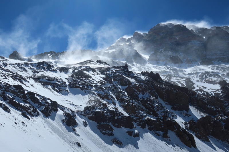
The benefit of the wind was that it scoured most of the deep snow off the upper mountain, making future travel easier.
Extreme winds scour the upper mountain
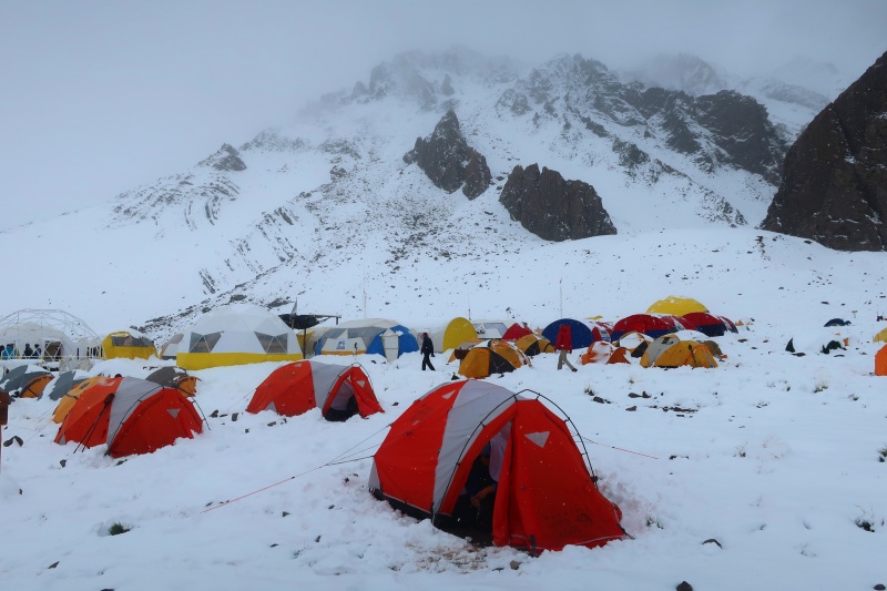
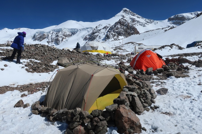
In basecamp, we rested, fortified the tents, and sorted gear to prepare for the upcoming days. Our 3-season Sierra Designs tent (yellow and gray tent in the picture) is not designed for extreme winds, so we spent a long time building a high rock wall to protect it from the strong gusts.
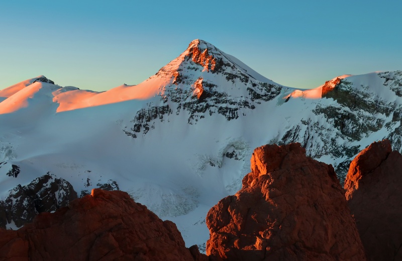
In the background, Cerro Cuerno (Mount Horn) loomed ferociously over the tents. It is one of the most beautiful peaks of the region.
Our basecamp tents with Cuerno in the background
Day 6: December 9 / Move to Camp 1 (Canada)
This was an exciting day, as it was the first time that any of us had camped above 5,000 meters. After waiting for the sun to warm the frigid morning, we hiked up the familiar path to Plaza Canada at 16,600 feet, where we recovered our cached gear and made Camp 1.
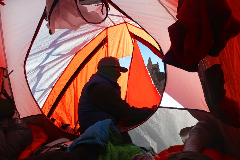
We ended up with two Trango 3 tents, one which we left set up at basecamp and one which we used at high camps. The Trango 3s performed admirably, with plenty of room for sleeping inside and gear organization / cooking in the vestibule. At Canada and higher camps, we would spend the better part of an hour using rocks to secure the tent's numerous guy lines and balloon stakes. The ground was usually too rocky and frozen to accept stakes, but with endless rocks lying around, the task of fortifying camp was straightforward, albeit time-consuming.
View from inside the Trango 3 tent
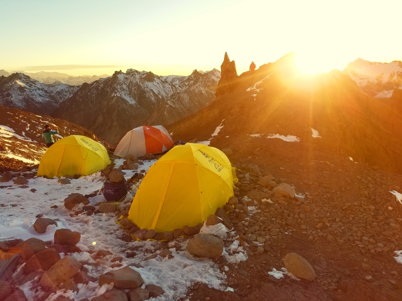
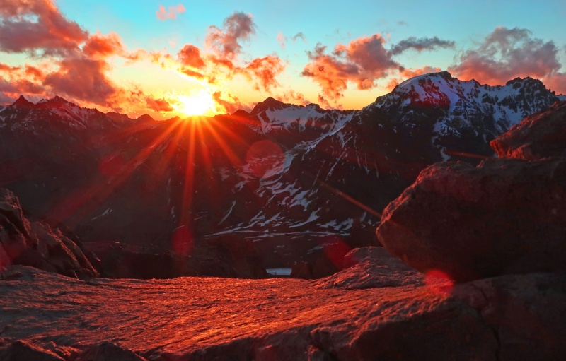
In the Argentinian summer, the sky stays light until about 9 p.m. I made a habit of staying up and photographing sunset from our high camps. My first high sunset was this night, at Plaza Canada. As the sun sunk behind the distant mountains of Chile, the camp took on an ethereal feel. A high camp is a fragile human toehold suspended in an extreme environment, but for a moment at sunset, everything felt settled and peaceful, like a blessing radiating onto the mountain slope.
Sunset, Plaza Canada
This view looks back on at the collection of tents nestled in a flat spot on the slope leading up to Aconcagua's looming bulk. The summit is about 6,200 feet above here, but with the foreshortening, it looks much closer.
Alpenglow on Aconcagua, Camp 1 on the left
The surrounding peaks caught incredibly beautiful light as well; Cerro Cuerno's dramatic ice faces were perhaps the most dramatic of all.
Sunset on the Horn
Day 7: December 10 / Carry to Camp 2 (Nido); Descend to Basecamp
After a good night's sleep, despite the altitude and wind, we spent the next morning carrying gear up to a large plateau at 18,200 feet called Nido de Condores, or Nest of the Condors. (A condor is a type of large raptor common in the area.) From Canada, the route traverses up and left across a fairly steep slope, which was complicated by all of the recent snow. Few people had been up this high since the storm, so I got to do some extremely aerobic step-kicking at 17,000 feet to establish the route.
Around 17,300 feet, the trail passes by some rock outcroppings popularly referred to as Plaza Alaska. This area is also called Cambio de Pendiente (Change of Slope) because the slope angle lessens above here. After another hour or so of hiking up a gentle fold in the mountain, we reached the windswept plain of Nido, a massive plateau on the shoulder of Aconcagua. Numerous rocks of jagged volcanic composure ring the borders of this area, and we found one of these which offered a protected spot from the wind where we left our gear cache.
Climbing the snow slope just below Plaza Alaska, 17,300 feet
After taking a break and caching some food and fuel, we headed back to basecamp. First, though, I used a little extra energy to detour to the summit of 17,828-foot Cerro Manso (Mount Meek), a gentle, low-prominence summit with great views in all directions. This was my first chance to see the dramatic peaks of Mercedario and Ramada to the north, and I was at eye level with the nearer summits ringing the Horcones cirque, such as Cuerno, Horcones, and Catedral. Most dramatically of all, the north face of Aconcagua rose 5,000-feet above me to its rocky summit.
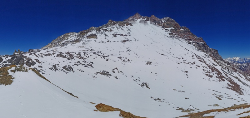
On the far left edge, the gray rocks of Nido de Condores are visible. The wide, central snowfield is the Gran Acarreo (Long Haul); at its top, it turns into the Canaleta. At the bottom right edge, the route going down to Canada is visible, and the shallow valley along the bottom is the route from Alaska to Nido. Overall, Cerro Manso offered an easy way of getting a great panorama of the upper route.
Panorama of Aconcagua's north slopes from Cerro Manso
Day 8: December 11 / Rest day in Basecamp
After our combination acclimatization hike / gear carry to Nido at 18,200 feet, it was time to have a rest and recovery day in basecamp. Besides, with the forecasting help of mountain meteorologist Chris Tomer, we knew that a period of lower winds was coming several days away, so we wanted to be rested and ready to make a summit push.
Already, most of the snow around basecamp had melted, making tasks easier. Alpenglow lit up the highest elevations of Aconcagua, some 8,500 feet higher than our tents.
Evening in basecamp, Plaza de Mulas, 14,300 feet
Day 9: December 12 / Climb Cerro Bonete; Move to Camp 1 (Canada)
Today, we woke up with the plan to make our move up to Camp 1. However, howling winds as low as basecamp convinced us this was a bad idea. Further, the weather was looking even worse for the next day, so we decided to stay two more days in basecamp to wait out the high winds.
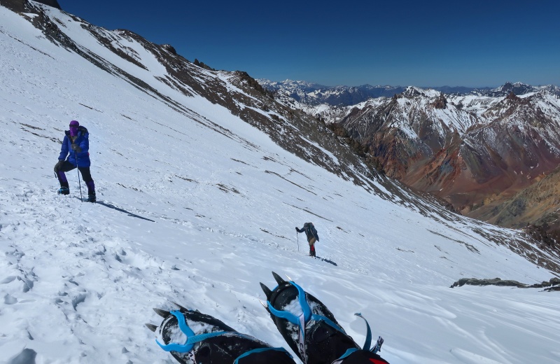
I decided to take a solo hike up Cerro Bonete, a 16,417-foot peak with almost 275 feet of prominence which is visually distinctive on the west edge of the Horcones cirque. A pleasant trail led up into a subsidiary hanging valley, and steep scree slopes with a little snow and rock mixed in led to the summit. I made good time on the ascent, climbing at a rate of about 1,400 vertical feet per hour, even above 15,000 feet elevation. The winds subsided enough for me to enjoy the summit for a little bit, including views of peaks in Chile and a bird's eye perspective on the lower Horcones Valley.
The two high, snowy peaks in the distance to the left of the summit cross are Nevado del Plomo, 19,915 feet (left); and Nevado Juncal, 19,521 feet (right).
Summit of Cerro Bonete, 16,417 feet, looking southwest into Chile
The biggest advantage to climbing Cerro Bonete was getting far enough away from Aconcagua to get a good angle for photography. Aconcagua's west face rises steeply above basecamp in this panorama, and with close inspection, many of the aforementioned landmarks (such as Plaza de Mulas, the Conway Rocks, Canada, Alaska, Manso, Nido, and the Gran Acarreo) are visible.
Aconcagua viewed from the slopes of Bonete
I descended very quickly and was back to basecamp in the early afternoon. At this point, the winds were lower, the skies were clear, and several teams had been visible moving up the mountain. We weighed our options and decided that our best chance was to go for it. With some hurried packing, we rushed off to begin our multi-day summit push around 2:30 p.m. Our packs were heavier than usual due to carrying extra gear for the summit bid, but we still made fairly quick progress, arriving at Plaza Canada with plenty of daylight to spare for pitching the tent and cooking dinner.
Dramatic evening light on Cerro Horcones (center) and the Horcones Glacier
Day 10: December 13 / Rest day in Camp 1 (Canada)
This day was forecast to have extreme winds up high, so we laid low in Canada. The previous night and early morning were indeed very windy, but we were lucky that the windstorm died down towards the afternoon, making it more enjoyable to hang out.
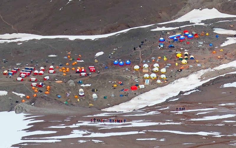
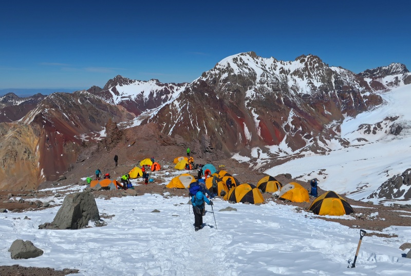
At one point, I walked over to the edge of the cliffs to get a view down to basecamp. This photo shows about 2/3 of the full tent city, which includes a medical center, a restaurant, many huge guiding companies, a porter service, and individual tents. Two groups are visible in the foreground, about a thousand feet above basecamp on the final approach to Conway Rocks.
Some quick thoughts about the larger guiding companies, such as the one in the center foreground: the clients have almost everything done for them, including carrying their backpacks, setting up their tents, and cooking their meals, and they often have little or no experience. In my opinion, this is really bad style. I think to count an ascent in good style, everyone should have a baseline level of experience, hire minimal support, and carry their own personal gear above basecamp. It seems that these huge guided groups are an over-commercialization of the discipline.
Plaza de Mulas seen from Plaza Canada
Anyway, not much happened this day, besides lying in the tent and enjoying our last day of relaxation on the mountain.
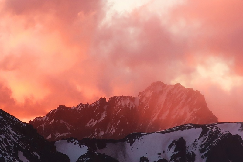
Towards evening, the rocks, near and far, lit up in shades of scarlet as the sun slid between the clouds on its journey over the horizon. It was rather surreal to stand at eye-level with the 5,000-meter peak I had climbed the previous day and watch the sun slide down its ridgeline. In this photo, Cerro Bonete is the small, triangular peak in the center, just right of the sun. Cerro Los Dedos is on the far left, and Cerro Catedral is the massive peak on the right.
Magnificent sunset from Camp Canada
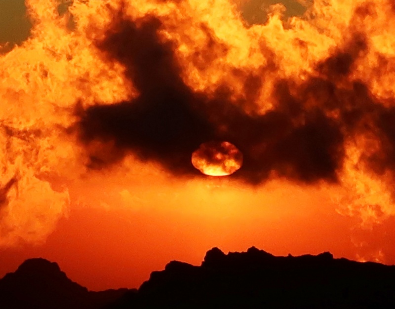
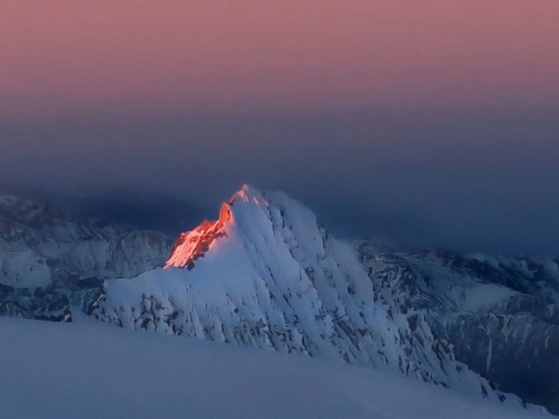
Cerro Pan de Azucar (Mount Sugary Bread) is a jagged fin of ice and rock that juts up from one valley over. This evening, it was shrouded in a mysterious pink cloud.
Cerro Pan de Azucar, elevation 16,732 feet
Everything seems more intense at high altitude.
Sundance
Day 11: December 14 / Move to Camp 2 (Nido)
The next day, we set out up the snow-packed trail with heavy packs, bound for Nido de Condores. This was our second time crossing these slopes, and the route was familiar. In addition, many other parties had passed this way, making the steps easier to follow. The crowded Camp Canada makes for a striking visual combination with the red rocks of the distant peaks. The colorful rocks of the Aconcagua environs reminded me of the San Juans in Colorado.
Leaving Plaza Canada with Bonete (16,417 ft.) and Catedral (17,238 ft.) in the background
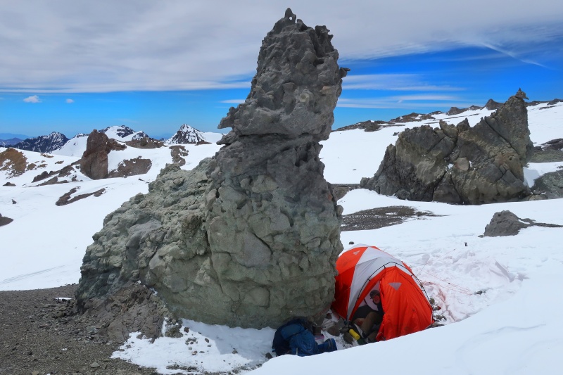
After finishing the familiar climb up to Nido, we recovered our cached gear and pitched the tent in a hole between a snowdrift and a rock pinnacle to provide wind protection. The rocks of Nido de Condores are distinct from the other areas of the mountain, as they have fantastical shapes and spires at every facet.
Camp 2, 18,200 ft., Nido de Condores
Nido is a large area and the groups tend to spread out, so we finally had a campsite that was fairly private. In the late afternoon, we walked over to the edge of the plateau, where Aconcagua's shoulder drops into the Guanacos Valley. This vantage point affords incredible views for a hundred miles to the north, with prominent peaks to the west and east, too. The Guanacos Valley is part of the Aconcagua Provincial Park, but sadly it is completely forbidden to visitors. It is completely illegal, with no permits or loopholes, to explore this ruggedly beautiful country.
Looking east to Cerro del Tambillo, elevation 18,635 ft.
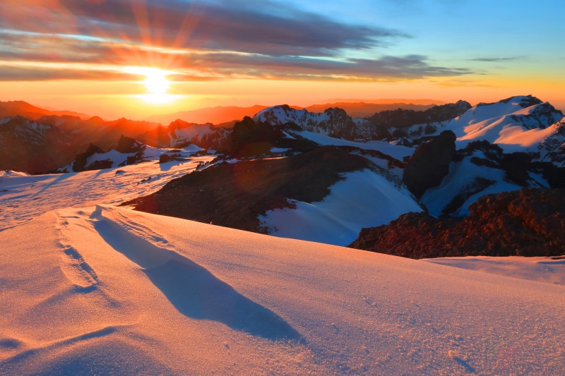
Sunset from Nido was one of the highlights of the whole trip for me: the vast sea of snow-clad peaks lit up in shades of yellow, pink, and red, with the deep valleys holding indigo shadows. I think this might be the best sunset picture I have ever taken.
Sunset, Nido de Condores
This shot provides a zoomed view of the next major peaks to the north. Mercedario, at 22,047 feet, is the highest summit on the left, with the broad, snowy plateau-like summit of La Mesa (20,210 feet) directly below and in front. The right-hand peak by itself is Ramada, elevation 20,866 feet. This trio of 6000-meter peaks provides a constantly daunting spectacle from the upper reaches of Aconcagua. Maybe my next Andes expedition will be there? One can dream.
Northward from Nido
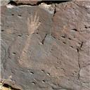
La Mano (The Hand) is an 18,044-foot fin of rock and ice on the edge of the forbidden Guanacos Valley. The fluted ice face was a high-quality technical objective for elite climbers before the Argentinian authorities closed all legal access several years ago. It may be possible to climb it from the back side, from the unrestricted Rio Volcan Valley.
Alpenglow on La Mano
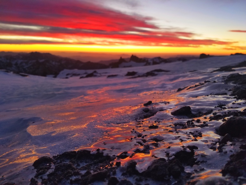
I caught the last light of sunset reflecting in a thin ice formation a little distance from camp. These are the moments we climb (and live) for.
Frozen sunset
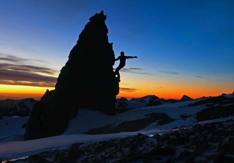
On a whim, I flipped the camera to self-timer and frantically clawed my way up this rock pinnacle with a couple seconds to spare, capturing this sublime moment.
Maybe I'm saying, "The trail goes up that way."
Last light
Day 12: December 15 / Move to Camp 3 (Colera)
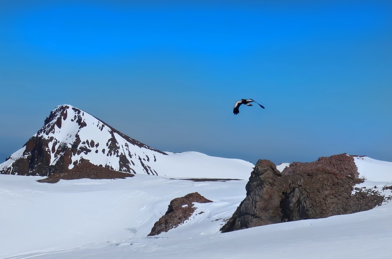
In the morning, while we were taking down the tent and packing our gear, I spotted a condor flying in the distance. I barely managed to snap a few photos before it disappeared, but it was cool to actually see one of the famous birds that the whole area (Nido de Condores) is named for.
Condor flying above Cerro Cuerno, seen from Nido
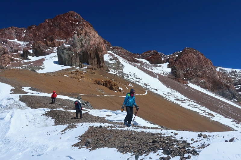
This day consisted of a short but very steep hike up to where we would make Camp 3, at Plaza Colera, elevation 19,600 feet. Our packs were exceptionally heavy today, as we had to carry everything necessary for two nights of camping plus our summit bid, and we had not done any previous gear carries to Colera like we had done for Canada and Nido. The path traverses some scree slopes before switchbacking up steep dirt with occasional snow patches. The whole time, the Mercedario massif provided a stunning backdrop.
This was a special day for all three of us, since a couple hundred feet above Nido, we all broke our previous altitude record of 18,491 feet (the summit of Orizaba). Every step above here was a new personal altitude record.
A note on clothing: We wore Scarpa Inverno double plastic boots the whole time we were above basecamp, but most of the time, during the day, it was warm enough to only wear a single shirt and maybe a light jacket. The sun's radiant heat sometimes made it so hot that I only wore a single, thin hiking shirt, even at 18,000 feet! In this picture, also notice my balaclava, which I wore daily to protect from further sunburn. At this point, most of my face was peeling badly as the final effect of the sunburn on our approach day.
On the way to Colera
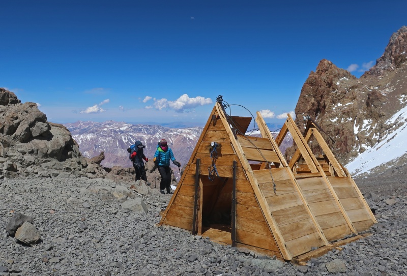
After two hours of climbing, we reached Berlin, a less-popular and slightly lower high camp with a couple of wooden huts. From there, the route to Colera traverses a dirt slope and climbs a short snowfield to some rock ledges. This section has some of the route's toughest climbing, and a steel cable provides extra assurance.
Final push up to Colera
The winds had died down to a reasonable level at this point in the expedition, and we had no trouble pitching the tent at Camp 3 on a little overlook. Colera is a spacious and beautiful camping area, with dramatic rock spires, natural crystals scattered around, and of course the ever-present views of Mercedario et. al. to the north.
We all felt well enough, and after cooking and eating dinner, we got to bed early to be ready for an early start tomorrow. The alarm was set for 4:30 a.m., the water bottles and inner boots were placed in our sleeping bags, and the die was cast. Tomorrow was our big day.
Camp 3, 19,600 feet
Day 13: December 16 / Aconcagua Summit Day
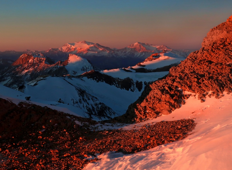
After getting dressed in the warm confines of our sleeping bags, we pulled on our outer plastic boots and started up the mountain at about 5:20 a.m. My toes started warm but began to grow cold as we climbed in the pre-dawn darkness. Before long, a sliver of the eastern skyline turned blue, yellow, and red, and moments later the northern peaks lit up in a fiery sunrise show. As we climbed to 20,400 feet, a little higher than the highest ground in North America (Denali), the backdrop was a radiant mixture of hues cut by the jagged spine of the Andes.
Summit day sunrise, 20,400 feet
Despite having started at about the same time, we were rapidly gaining ground on the guided groups, and at this point I believe we were the highest people on the mountain. We reached Independencia Hut, at 21,000 feet, moments before the sun brought its warmth to our cold faces and rapidly freezing toes. Reassured by this newfound warmth, we rested for a while here, eating some snacks and drinking tea from a thermos. Supposedly, the ruins of this wooden hut form the highest man-made shelter in the world.
Independencia (photo taken on descent)
We put on our crampons at Independencia and continued up a moderate snow climb to a section called the Windy Ridge. Luckily, Chris had helped us choose a great weather window, and it was only slightly windy as we crossed this section. Beyond, we lost the sun's warmth again as we started across the shaded section La Traversia, a trail leading up and across the vast scree field of the Gran Acarreo. This photo (taken on the descent) provides an overview of the area. At the far side of the traverse, we continued climbing deliberately upward and rightward, crossing some larger snowfields and resting frequently as the altitude took its toll. In addition to looking at the distant and close peaks, I enjoyed the vertigo-inducing view down to basecamp, where I could just make out the shapes of tents some 7,200 vertical feet lower.
Most of the time, though, I simply concentrated on breathing and stepping, often mentally counting my breaths to give myself a feeling of progress. 30 breaths, stop, rest for 20 breaths. Continue.
Cresta de Viento and La Traversia (taken on the descent)
The views became different as we climbed, despite looking at the same mountains. The close peaks of Cuerno, Horcones, Catedral, and Bonete faded into a single sea of rock and snow far below us, while the 6000-meter peaks to the north stood out with prominence. At long last, the sun crested the ridge and brought warmth as we reached the base of the Canaleta (Gutter) at 22,000 feet above sea level. Here, a huge yellow rock escarpment creates a cave (aptly called La Cueva), where we rested and had another snack break. We were still the highest group, and making good time to beat, having climbed the thousand feet from 21,000 to 22,000 in only two hours.
The Canaleta is infamous for its unstable slopes, steep gradient, and unrelenting mental and physical difficulty. Luckily for us, the snow storms that had plastered us on our first days had also deposited a firm layer of snow over the Canaleta's unstable rocks, allowing us to crampon up firm, enjoyable snow instead of sliding backwards on loose scree. Still, the extreme altitude was taking its toll, and we slowed to a pace of about 250 vertical feet per hour.
The Canaleta--snow climbing at 22,000 feet
The Canaleta broadens at the top, turning into a small cirque where we climbed up to just below the crest of the Guanacos Ridge connecting Aconcagua's north summit and (lower) south summit. From here, we traversed some large talus and snow, trying to stick to the snow when possible since it was more stable and easier walking in our crampons. A French team passed us and returned quickly from the summit--we were close! After crossing the top of the Canaleta's cirque, we scrambled through some large boulders for a few dozen feet to top out on a small plateau with nowhere higher to go--the SUMMIT!
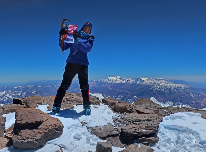
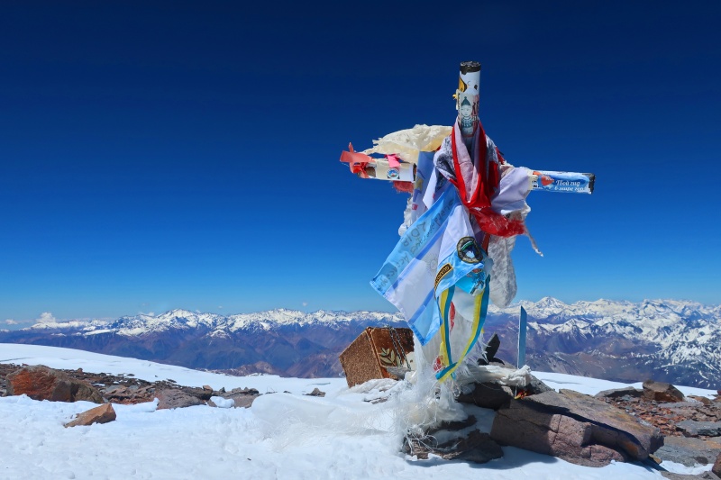
Feelings of joy, relief, and accomplishment swelled like a sudden dramatic orchestra as we stood at the pinnacle of the magnificent cathedral of the Andes. We were the highest people in the American continents, and for a few moments nothing else mattered. The sky was blue, the wind was present but manageable, and the day was absolutely gorgeous.
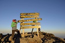
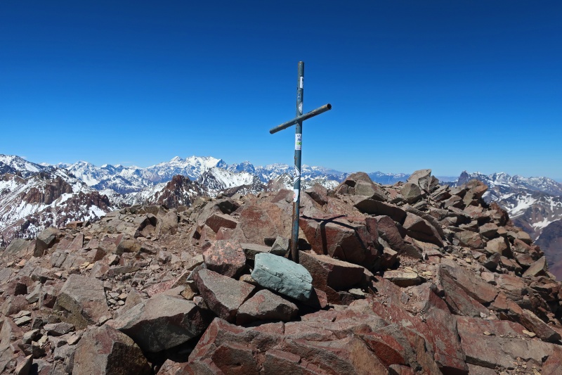
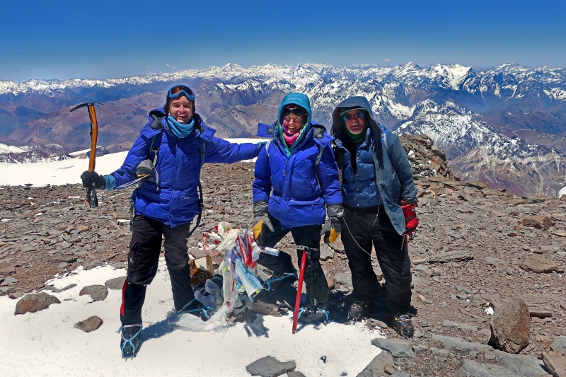
Excelsior! 22,841 feet.
Me holding the American and Colorado flags on the summit of Aconcagua
We spent quite a while on top enjoying the views and making the moment last. We were lucky to be the only group on top at the time, the French team already having descended when we reached the top. After a little while, another group of two topped out, and after sharing congratulations, our groups traded photo ops. What better place for a family portrait than the highest summit in two hemispheres?
The iconic Aconcagua summit cross is visible in the foreground with its drapings of various banners and ribbons.
Happy family, made the summit
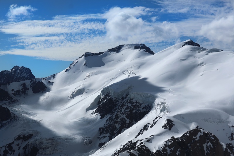
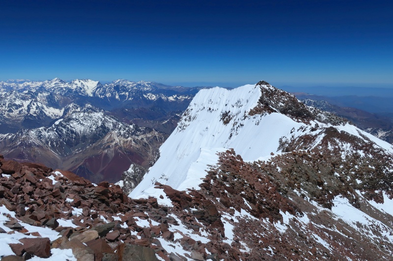
The dramatic South Peak of Aconcagua loomed a few hundred feet lower at the other end of the Guanacos Ridge, with the lowlands of Chile stretching out behind on the right.
South summit of Aconcagua, elevation 22,408 feet
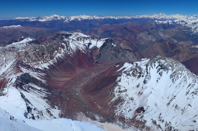
We lounged on top for the better part of an hour before heading down. Along the way, I stepped a few feet left of the path to peer down the incredible South Face, an 8,000-foot sheer cliff of ice, hanging seracs, and vertical rock that drops precipitously into Plaza Francia. This is the site of world-class big mountain technical routes, and it was amazing to look down from the top.
The snowy peak in the lower right-hand corner is Cerro Mirador, at 18,081 ft. Looking to the horizon, I could see endless peaks. Cerro Tupungato, the beautiful bell-shaped mountain on the right side of the horizon, is the highest peak to the south, at 21,539 ft.; the prominent peak on the left side of the skyline is Cerro El Plata at 19,488 ft.
View south over Plaza Francia
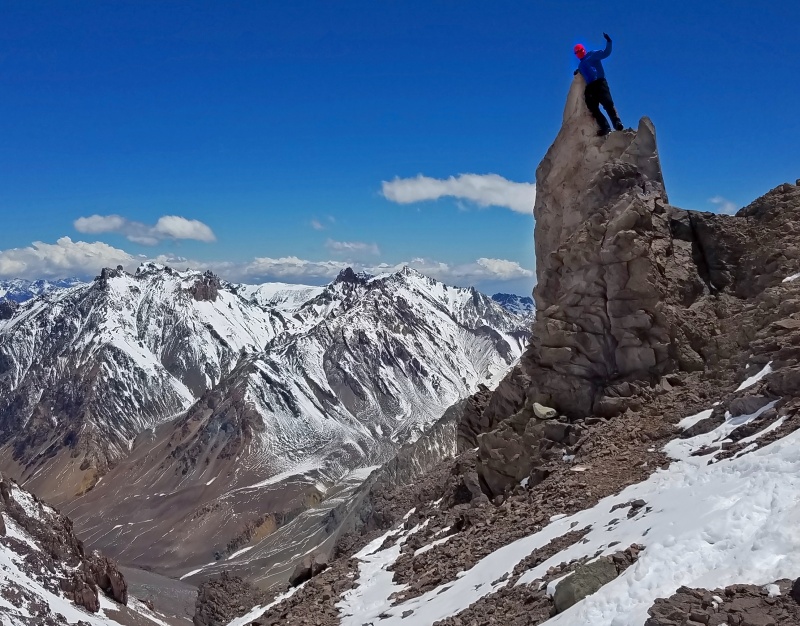
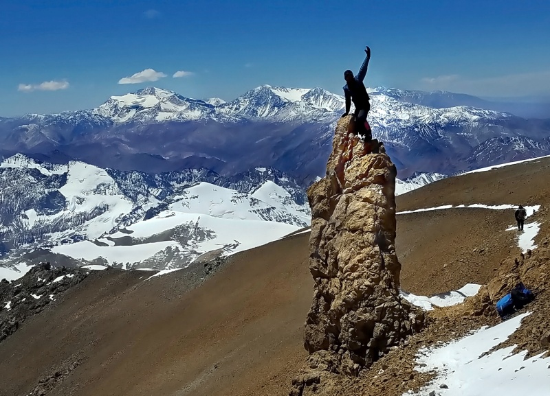
The descent went much quicker than the ascent of course, and before long we were back on the Traverse. I walked quickly to get ahead of the group and scampered up this little rock pinnacle popularly called "El Dedo" or The Finger.
Sometimes you just get the urge to scramble up a loose, chossy volcanic pinnacle at 21,500 feet, I guess. Afterwards, we finished our descent to Colera, where we collapsed for the night.
High Jinks!
Day 14: December 17 / Descend to Basecamp
Our last day high on the mountain saw us getting a leisurely start from Colera and descending quickly to Nido, Canada, and finally to Mulas. At each intermediate camp we passed, we had to retrieve the rest of our cached gear, including leftover food, fuel, etc. By the time we left Plaza Canada headed down, my pack must have weighed at least 80 pounds, and with a duffel bag strapped on the back, it looked a little like I was trying to carry an entire house.
We plodded carefully back to basecamp, where we sorted gear and arranged with Andesport Expediciones to hire a mule to carry a few duffel bags out to Horcones. Several companies run mules each day, and almost all climbers send some weight via the mules. Despite sending out about 55 kilograms via mule, we still carried 40 to 50 pound packs for the hike out.
Heavily loaded on the descent to basecamp
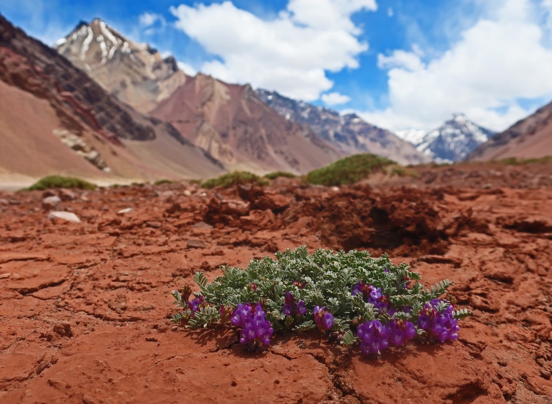
Day 15: December 18 / Trek Out to Horcones
After our final night on the mountain, we got an early start and hiked the 15 miles downhill to the Park entrance at Horcones. The views were dramatically different from when we entered--where there had previously been snow, now the valley consisted of dry rocks and cracked dry mud fields. A few tenuous plants clung to life in these harsh environs.
Springtime in the Andes
After finishing the dusty, dry hike out to Horcones, we drove to Uspallata where we spent a few nights in the Gran Hotel, eating the wonderful local cuisine and enjoying poolside relaxation. On the drive back to Mendoza for our departure, we stopped at Termas de Cacheuta, a lovely hotspring spa where we finished the "relaxation phase" of the trip.
Final Thoughts:
Overall, the trip was a huge success. Supposedly, about 30% of people who attempt Aconcagua make it to the summit, so we were blessed to have the whole family counted in that group. Thank you to my parents, for helping and joining me on this expedition! Thanks also to the Dartmouth College Outing Club for sponsorship and partial funding. Thanks to Chris Tomer for the great forecasting service that let us pick the best possible summit day.
Would I recommend Aconcagua? Yes. It's a fine mountain, with beautiful views and an overall enjoyable route. The Provincial Park Service is annoying at times, like when I got whistled at for glissading (apparently glissading is too dangerous), but overall, it can be dealt with. The campsites can be crowded and some of the groups are rude, but the spectacular sunsets make up for it. After all, it's the highest peak outside the Himalaya, so what more could we have possibly asked for besides to have all of us summit under great conditions, which we did?
I guess you could say it was one of those perfect moments.
Edit / Update: Here is the trailer for the feature film I am producing from this expedition. The film explores the question of "why do we climb" in a relatively broad context, but the focus is on Aconcagua.
Vaya con Dios!
Summit of the Americas, 22,841 feet above sea level
Thumbnails for uploaded photos (click to open slideshow):
From a Dartmouth alum and someone heading to Mexico's high volcanoes in a week...this really makes me excited at the thought of attempting Aconcagua someday! Great trip report and great photos!
Very cool. Aconcagua was a much more enjoyable experience than I had expected. I recommend it to everyone. Nice write up, it took me back. What's next? You should do Denali!
@ChrisinAZ, that's awesome that you're a Dartmouth alum! As a '22, I'm just starting to explore the DOC, but I've already met lots of great outdoors people there and can't wait to do more with the club. Good luck in Mexico, and let me know if you ever want to do a "Dartmouth hike."
@I Man, @jbchalk, @kushrocks, thanks for the comments guys, it means a lot coming from some of the forum's most accomplished big-mountain climbers. For those asking what next, I do indeed want to do Denali, but probably not too soon, due to a combination of partners and the route I want to take. I think my next big goal will be something a little closer to home, another list in a different state, with a FKT attempt thrown in. After that, I'm looking into logistics for another big mountain of similar elevation to Aconcagua on the other side of the world. My school calendar just so happens to line up very nicely with the fall or spring Himalayan seasons...
@SplanoKC, thanks Craig! Nothing better than summits with the family.
One word though...Establish your own style or rules if you will and follow them, but try not to impose them on others, good style is relative and that's all good but stating that someone's good style is somehow less than yours or not worthy to count is lame. mountaineering is a personal endeavor and should be kept that way.
Great TR on Aconcagua! I climbed with friends a couple years ago and had a great time. We went Plaza Argentina then down Mulas. On summit day we hiked all the way down to Mulas and caught a heliocopter out. Cheating, yes, but I was drinking a fine Malbec and eating a cheeseburger the night after I summited.
Congratulations on the achievement! I completely enjoyed the pics and your writing is top notch! Acon is on my bucket list as well but most probably 2 years away.
@Jay, I think the next project will be Wyoming peakbagging, but the next big mountain will probably be Kilimanjaro.
@ScralptheGnar,"mountaineering is a personal endeavor," yes, precisely my point, mountaineering should be personal and not over-standardized and over-commercialized. These big guiding companies do not provide for personal endeavor.
@jbprof, good question, I forgot to include that in the report. We used a GravityWorks/Platypus gravity water filter in Confluencia and basecamp, and boiled snow for water at all of the high camps. Since we booked Grajales mules to enter the park, they let us dip water from the barrels they fill with a hose that comes from a distant pond in basecamp. We were not sure about the cleanliness of this system, so we filtered it anyway. Up high, there was never any liquid water to be found, so we didn't carry the filter and instead just boiled the snow.
Never looked at the Platypus gravity filter. Looks like a great option versus the MSR Guardian style filters. Did you have any issues with silt? I've been told the water in & around Aconcagua is ultra-silty.
We didn't encounter any silt problems, but our liquid water came from the barrels that are filled from nearby ponds via long hoses and pumps, so I don't know how the melt-water sources would have been. I also don't know how standard it is for the mule companies to let people take water with the only contracted service being the mules. We were surprised that they offered to give us water from the barrels in basecamp.
I think that a lot of the silt issues are from people collecting melt-water during high season (late Dec through Feb) at the high camps, but since we just boiled snow, we were fine in that regard. It never got above freezing on the upper mountain, so there were no melt-water sources.
Caution: The information contained in this report may not be accurate and should not be the only resource used in preparation for your climb. Failure to have the necessary experience, physical conditioning, supplies or equipment can result in injury or death. 14ers.com and the author(s) of this report provide no warranties, either express or implied, that the information provided is accurate or reliable. By using the information provided, you agree to indemnify and hold harmless 14ers.com and the report author(s) with respect to any claims and demands against them, including any attorney fees and expenses. Please read the 14ers.com Safety and Disclaimer pages for more information.
Please respect private property: 14ers.com supports the rights of private landowners to determine how and by whom their land will be used. In Colorado, it is your responsibility to determine if land is private and to obtain the appropriate permission before entering the property.


")
")
")
")
")
")
")
")
")
")
")
")
")
")
")
")
")
")
")
")
")
")
")
")
")
")
")
")
")
")
")
")
")
")
")
")
")
")
")
")
")
")
")
")
")
")
")
")
")
")