Download Agreement, Release, and Acknowledgement of Risk:
You (the person requesting this file download) fully understand mountain climbing ("Activity") involves risks and dangers of serious bodily injury, including permanent disability, paralysis, and death ("Risks") and you fully accept and assume all such risks and all responsibility for losses, costs, and damages you incur as a result of your participation in this Activity.
You acknowledge that information in the file you have chosen to download may not be accurate and may contain errors. You agree to assume all risks when using this information and agree to release and discharge 14ers.com, 14ers Inc. and the author(s) of such information (collectively, the "Released Parties").
You hereby discharge the Released Parties from all damages, actions, claims and liabilities of any nature, specifically including, but not limited to, damages, actions, claims and liabilities arising from or related to the negligence of the Released Parties. You further agree to indemnify, hold harmless and defend 14ers.com, 14ers Inc. and each of the other Released Parties from and against any loss, damage, liability and expense, including costs and attorney fees, incurred by 14ers.com, 14ers Inc. or any of the other Released Parties as a result of you using information provided on the 14ers.com or 14ers Inc. websites.
You have read this agreement, fully understand its terms and intend it to be a complete and unconditional release of all liability to the greatest extent allowed by law and agree that if any portion of this agreement is held to be invalid the balance, notwithstanding, shall continue in full force and effect.
By clicking "OK" you agree to these terms. If you DO NOT agree, click "Cancel"...
Mount Katahdin is not a 14er. It is not even in the Colorado Rockies. But it is a mountain worthy of a report.
Mount Katahdin is a horseshoe-shaped mountain complex of peaks located in central Maine. It was named Katahdin, the Greatest Mountain, by the indigenous Penobscot Indians. The state highpoint, it lies within Baxter State Park and is the northern terminus of the Appalachian Trail. There are several routes up the mountain but all involve at least some scrambling, ranging from Class 2 to Class 4.
Back in 2002 I climbed it taking the Helon Taylor Trail from the Roaring Brook Campground up to Pamola Peak. I then traversed across the Knife Edge to reach the summit of Baxter Peak. I descended via the Saddle Trail and returned to Roaring Brook along the Chimney Pond Trail.
But on that particular day the weather was not optimal. A thick curtain of cloud and mist hung directly over the entire high ridge of the mountain dividing it in two and preventing any kind of view to my left as I scrambled over the rocks.
It was such an amazing experience, however, that I vowed to return and climb it again someday. I especially wanted to return in the fall when the trees were turning color. I was also anxious to ascend via the Cathedral Trail, which I later read was an interesting scramble.
A little over a year ago my friend, John, and I got to talking about Katahdin. We discovered that each of us had climbed it in the past and both of us have always wanted to return and try it again. We made arrangements to attempt it this year.
As neither of us do camping anymore, we booked a couple of nights at the Big Moose Inn, Cabins and Campground, a lovely old resort with lots of rustic character and flavor. I highly recommend this place, especially a room in the Inn where you get an excellent breakfast included in the price. The staff are all very friendly and helpful and cater to your every need.
The Big Moose Inn as seen from the road.
The Climb:
As we noted when we drove up to Millinocket from Portland the day before, the spectrum of color in the trees got progressively better the farther north we went. When we started our first hike from Roaring Brook, we could tell immediately that the hardwoods were now in their prime; the splash and contrast of color was amazing!
Roaring Brook at the start of the trail.
The Chimney Pond Trail closely parallels Roaring Brook initially for about a quarter mile before branching away. It is a rugged trail and because the area had been under considerable rain for the past several days, the wet leaves and roots along with damp, moss-covered rocks made for slick footing. It was an overcast day for the most part, but at least it wasn’t raining during this hike. The colors of the trees, however, seemed to emit their own soft glow even without sunlight shining through them.
The rugged Chimney Pond Trail.John following the blue blazes.Beautiful path!Rocky steps
There are several timbered bridges, as well as a few raised split log sections along the way, which made passing over marshy areas and wetlands much easier.
Getting ready to take another photo.
When the cover of the trees opened up briefly, we got our first glimpse of Pamola Peak with the western edge of Katahdin peeking around behind it.
Finally we reached Chimney Pond, a small glacial lake within the cirque of the South Basin. There was another Ranger Station there where you are encouraged (required?) to check in and record your plans for the day. She warned us about a strong wind advisory and cautioned us against crossing the Knife Edge.
Chimney Pond, just below the Rangers Station.
Originally, John and I had planned to ascend the mountain separately, he by way of the standard Saddle Trail and I taking the Cathedral Trail. We would meet at the summit and then continue over the Knife Edge and return down from Pamola if conditions were favorable. If the weather was as bad as predicted, we would just return via the Saddle Trail.
John had done the Cathedral route in the past and told me now, “That’s not a trail for old guys!” It wasn’t so much about the exposure, he explained, it was more about stiff knees and joints reaching for high steps and footholds and pulling yourself upward. But I had my heart set on trying the Cathedral Trail ever since I read a description about it after my last ascent of Katahdin. Although I was willing to go it alone if need be, I’d prefer to have a partner along.
We went down to the lake to take a short break and get a little nourishment and water. Three young men were already sitting there now. They had passed us on the trail just prior to reaching Chimney Pond. Talking with them, they told us they were taking the Cathedral Trail up. I asked if they would mind if I tagged along and they were all agreeable. This would work out well for all of us! We would meet John on the summit.
The sharp ridge of the Cathedral Trail as seen from Chimney Pond.
Bidding John a safe hike, the four of us branched away heading southwest on the Cathedral Trail. Almost immediately it took to the boulders and began its initial climb up to the first ‘Cathedral.’ All the routes up Katahdin, including this one, are marked with painted blue-blazes, so each route is roughly identified.
Matt, Ryan, and Will starting up the Cathedral Trail.The first 'Cathedral,' our initial goal.Headin' on up!
As we climbed, we introduced each other and got better acquainted. Ryan, Will, and Matt, all in their early 20’s, were all merchant marine engineers. When I asked what they did exactly, they replied, “We keep the propellers spinning and the lights on.” Kind of like Scotty on the Star Trek Enterprise, I guess!
Looking back down to Chimney Pond.Climbing up the eastern flank of the first Cathedral.
After attaining the first Cathedral, we took another short break, Matt, Ryan and I on the apex. Will was content to remain at the base below us.
Matt and Ryan on the top of the first Cathedral.MtnHub also on the Cathedral.
Looking over to the Saddle, I tried to spot John ascending in the gully but he was likely hidden from view within the scrubby brush.
The Saddle and the gravelly gully John was going up.
We continued on to the next Cathedral and eventually saw the junction of the Cut-Off Trail.
Matt giving a 'thumbs up' sign as the Cut-Off cairn and marker are spotted up ahead.
The Cut-Off Trail traverses over to the Saddle in a relatively level manner and bypasses the final Cathedral. It acts mainly as a safety exit should bad weather arise unexpectedly. But we kept going upwards on our way to the summit.
Looking back down at Chimney Pond and the Basin Ponds.Climbing up the last Cathedral.A quick breather.
While it had been quite windy the entire time we were climbing, once we got out of the large boulders and over the more exposed rim, the gales were really strong. The ranger’s prediction held firm, and if you were not careful and braced yourself, it could easily knock you over.
Coming out of the boulders to the final stretch to the summit.
It was difficult to take a decent summit shot of each other, because holding the camera still enough in the galing wind was nearly impossible.
Will, Matt, and Ryan hanging on for dear life.MtnHub's second summit of Katahdin.
I was also amazed at the number of Appalachian Trail finishers coming up from west on the other side. There were literally streams of them climbing up along the Hunt Trail. I had no idea that that many hikers finished the nearly 2,200 mile trek originating in GA. Matt, who finished the long trek himself last year, even recognized a few of them.
AT finishers on the summit. Note the other through-hikers coming up the trail on the other side.
It was fun to witness the excitement and celebrations they all shared in joining up with each other at the top.
AT finishers celebrating at the top, culminating their long hike from GA.
Looking over at the Knife Edge and Pamola Peak, I was sadly thinking we would not be able to continue around on it. The wind just made it so much more treacherous and dangerous to even attempt.
Pamola Peak and the Knife Edge.
John finally arrived about 30 minutes after we had made the summit, and we had someone take our picture in front of the large summit cairn for documentation.
John and I at the Baxter Peak summit cairn. (South Peak on the right)
After a long stay on the top, we finally became chilled enough with the need to get moving again. The trail down to the Saddle is a fairly gentle grade, but the rocky pathway in conjunction with the extreme wind pushing hard on us from the side, still required us to proceed slowly and cautiously.
John heading down to the Saddle.The stark look of the alpine terrain.Cairns and blue blazes line the way.The Great Basin, just before we drop down into the gully. Despite the winds we were experiencing, those clouds over the valley persisted the entire day.
Clumps of alpine grasses were whipping around us, and in spite of it all, it was rather exhilarating to experience.
The mouth of the Saddle gully.
The steep Saddle gully was quite tedious and even more slow-going. At least the rocks on the alpine plateau were fairly stable but you really had to watch your every move in the looser gully. Once we finally reached the trees again the trail leveled off a bit and became the usual woodland trail.
John descending the Saddle gully.
About halfway down the Chimney Pond Trail we came across a bird sipping water from a puddle on a flat-topped boulder just adjacent to the trail. We slowly walked up to it but it didn’t seem to be bothered by us at all. It just stood there and almost posed for us until it finally moseyed into the woods.
A Franklin Spruce Grouse.
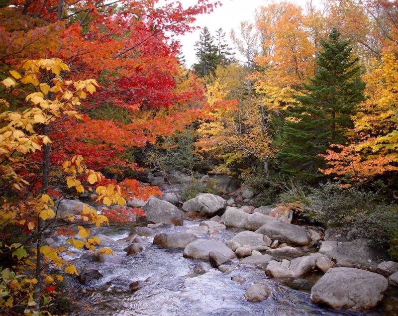
The end of our hike was like the beginning. We passed through more hardwood forest so we were surrounded by more color the closer we got to the trailhead. A pleasant way to end our day.
The colors of fall.
When we signed out at the Roaring Brook Ranger Station, we showed the image to the ranger on duty. He identified it as a spruce grouse. Later after I returned home and did more research, I discovered it was actually a Franklin spruce grouse, a sub-species of the spruce grouse. They are apparently quite rare to spot so we were thrilled to know we had witnessed it on this hike.
Thumbnails for uploaded photos (click to open slideshow):
Brings back memories of me cutting my hiking teeth as a kid. Also in high school my whole biology class hiked it - also the first weekend of October for max fall colors. Good timing on your part, and great pics and report!
Druid - Yes, the time we went was the perfect time , trees were at their peak of color! That's exactly what I was hoping for.
Eddie - The Rockies are really my favorites, but New England has a lot of beauty to offer in a very different aspect. But yes, they are definitely worth the effort to experience!
Glenmiz - I was hoping to also get into the NH Whites again and hit Washington and some other Presidentials once more on this trip. But weather was not good at all for those planned days. But the two days we had on Katahdin made the whole trip worth it!
So glad you were able to get out and up so successfully on these peaks!
Gorgeous time of year to hike.
I love northern New England summits.
I bet we crossed each other on the interstate in ME. I was just up there visiting my mom 10/5-10/9.
Really enjoyed your reports - and happy for you! :D
Jay - that trip has been in my mind for many years but I knew I would never be able to try it in Oct when I wanted to do it until after I retired. So for the last couple of years it's been forefront in my mind. It was purely by chance that we discovered each of us wanted to do it again, and it worked out well this year. John was a great partner.
Nancy - good to hear from you! Yeah, we easily could have crossed paths. We drove down to Portland on I-95 Sat morning Oct 6.
Katahdin is #1 on my short list of state high points climbed and this route is why. It is non stop scrambling with zero slogging from start to finish. Is there anything comparable to this in Colorado? Had the same grin from ear-to-ear as you partners had. This is worth repeating! Also I drove to Acadia NP after the climb on Katahdin, car camped then woke up to the sunrise and it's fun to say I was the first person in the USA to see the sunrise since I'm literally on the farthest eastern point in the country.
Caution: The information contained in this report may not be accurate and should not be the only resource used in preparation for your climb. Failure to have the necessary experience, physical conditioning, supplies or equipment can result in injury or death. 14ers.com and the author(s) of this report provide no warranties, either express or implied, that the information provided is accurate or reliable. By using the information provided, you agree to indemnify and hold harmless 14ers.com and the report author(s) with respect to any claims and demands against them, including any attorney fees and expenses. Please read the 14ers.com Safety and Disclaimer pages for more information.
Please respect private property: 14ers.com supports the rights of private landowners to determine how and by whom their land will be used. In Colorado, it is your responsibility to determine if land is private and to obtain the appropriate permission before entering the property.


")
")
")
")
")
")
")
")
")
")
")
")
")
")
")
")
")
")
")
")
")
")
")
")
")
")
")
")
")
")
")
")
")
")
")
")
")
")
")
")
")
")
")
")
")
")
")
")
")


