Download Agreement, Release, and Acknowledgement of Risk:
You (the person requesting this file download) fully understand mountain climbing ("Activity") involves risks and dangers of serious bodily injury, including permanent disability, paralysis, and death ("Risks") and you fully accept and assume all such risks and all responsibility for losses, costs, and damages you incur as a result of your participation in this Activity.
You acknowledge that information in the file you have chosen to download may not be accurate and may contain errors. You agree to assume all risks when using this information and agree to release and discharge 14ers.com, 14ers Inc. and the author(s) of such information (collectively, the "Released Parties").
You hereby discharge the Released Parties from all damages, actions, claims and liabilities of any nature, specifically including, but not limited to, damages, actions, claims and liabilities arising from or related to the negligence of the Released Parties. You further agree to indemnify, hold harmless and defend 14ers.com, 14ers Inc. and each of the other Released Parties from and against any loss, damage, liability and expense, including costs and attorney fees, incurred by 14ers.com, 14ers Inc. or any of the other Released Parties as a result of you using information provided on the 14ers.com or 14ers Inc. websites.
You have read this agreement, fully understand its terms and intend it to be a complete and unconditional release of all liability to the greatest extent allowed by law and agree that if any portion of this agreement is held to be invalid the balance, notwithstanding, shall continue in full force and effect.
By clicking "OK" you agree to these terms. If you DO NOT agree, click "Cancel"...
It's more fun when you have no idea if your plan is possible!
Weather forecast was perfect again so I threw my gear in the truck and called in sick for another 4 day weekend. My target was the Grenadiers to keep working at my top 200 list. Having just done Jagged, Animas group, and Pigeon group 2 weeks before from Purgatory I needed to shake it up a bit so I looked for another approach that would let me see more nooks and crannies of this great state. This time I drove in from Creede to the Rio Grande anti-Reservoir and pedaled my 2 wheeled Strava hunter into Kite Lake to start my walking adventure. This trip would bring me to 79 summits for the year and like all of my trips before, the plan was to connect the dots in the most geometrically pleasing GPS track I could muster. Out and back day hikes from basecamps might as well be camping with a Yeti Cooler beside your 4Runner in a rooftop tent with a dog and 1.5 kids. I don't have 1.5 kids. Or any of that other stuff, for that matter. Loops are king!
After giving my bike a nice warm hug and leaving it a dish of water I locked it to a pole and set off up White Dome and over to Peak One. Straight forward stuff.
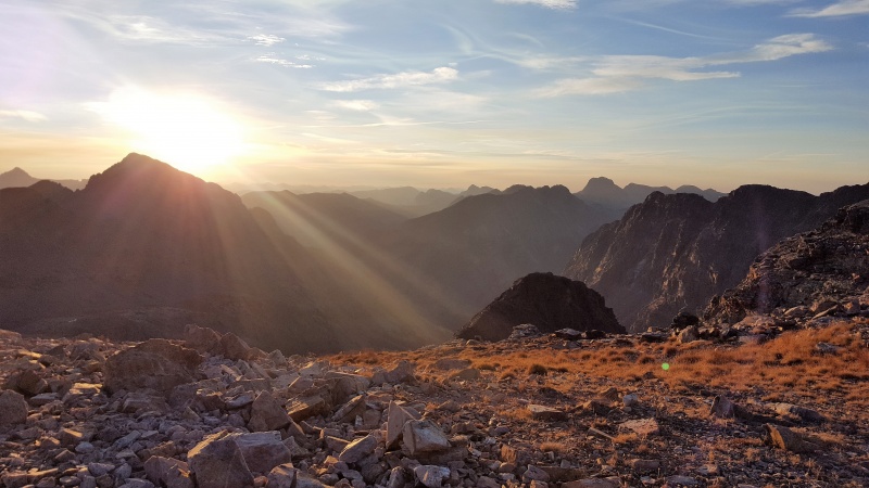
Kite Lake - The fun begins
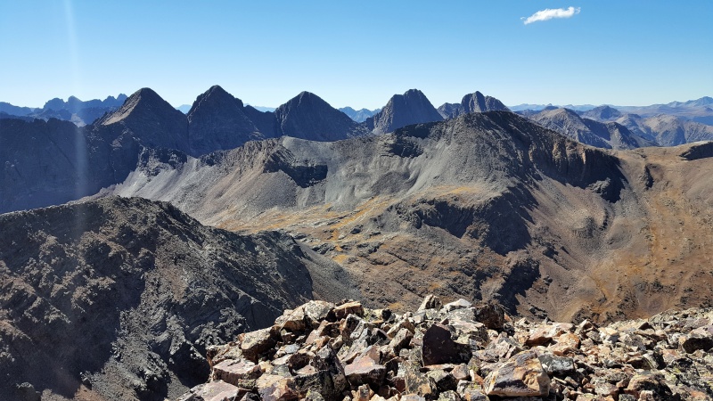
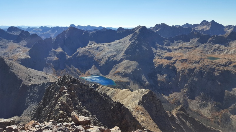
On Peak One looking at the Trinities, Vestal and Arrow
It's always a great idea to do an Idiot Check every time you get up from a sit-down. Guess what idiot didn't do his Idiot Check? Huh, huh? Yeah, you guessed it. If anyone wants a sweet stove, new fuel canister, Gucci cuben fiber stuff stack in a titanium pot, just have a quick look on one of these two summits. It will be sitting right there for ya just a few yards from the summit! If you feel guilty, I'll pay for shipping and you can send it back to me but I wont think anything less of you if you keep it cause I'm a dumbass. Just send me a picture enjoying a warm meal to rub in the fact that I got to eat cold mush out of a ziplock baggie for the next 4 days!
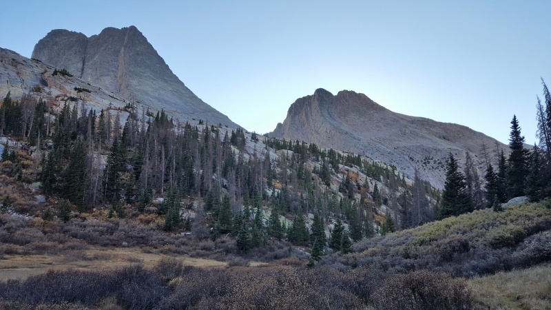
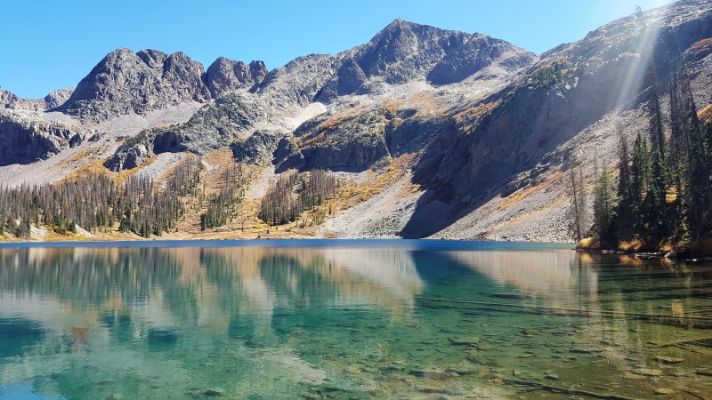
Vestal and Arrow stood guard and kept me safe all nightBreakfast was a perfectly prepared scramble up Arrow with a side cold oatmeal.
Day couldn't have been better! One of these days Travis Pastrana is going to do something ridiculous on Vestal.
After a quick little out and back on Arrow it was time to get back with the plan. I grabbed all my stuff and backpacked over Wham Ridge, yelling encouragement on some new friends, Katie and Greg, that were half way up Center Shift when I shuffled on by. Being my second time up Wham, it was 100% fun being on perfect rock with a firm notion of what was lurking ahead. I did have climbing shoes the first time I danced with Wham but this time but I opted to leave them at home.
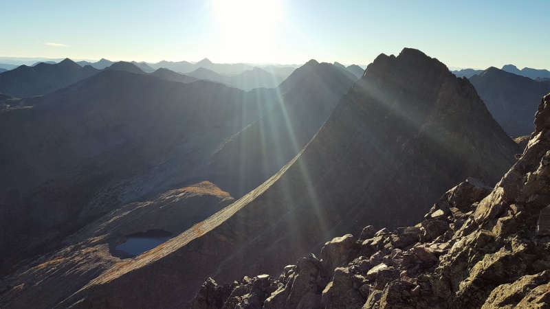
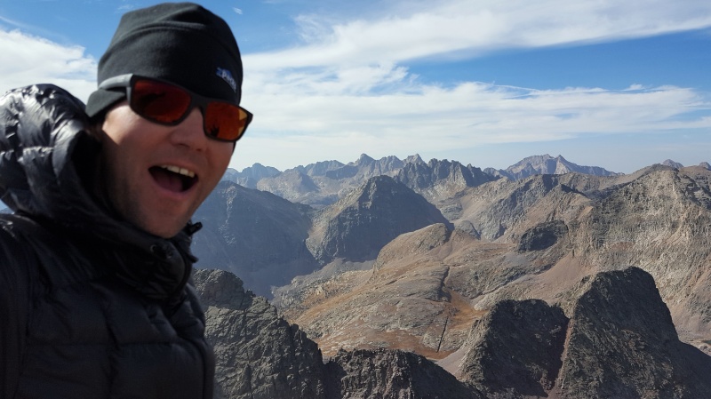
The view from the top of Vestal!
Once on top I threw my loose game plan out the window and made a Bee line for that magnificent looking lake!
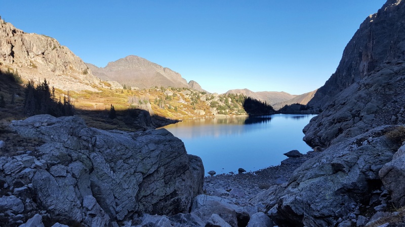
Rest stops dont get better than this!
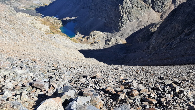
To my surprise there was a really good trail leading out and up to the shoulder of Peak Six, no doubt from the adventurous folks that link up Wham over to Jagged. For me I put on my blinker and made a hard left turn up to the top of Six by mid afternoon. I really wanted to bust a move across the ridge directly to Seven but figured darkness might catch me before I can get off of it. Hunting for a campsite in the dark pushes the epic meter farther than I wanted for this trip so instead I took the express train down off the first low point on the ridge into Leviathan Lake.
Surf's up dude!
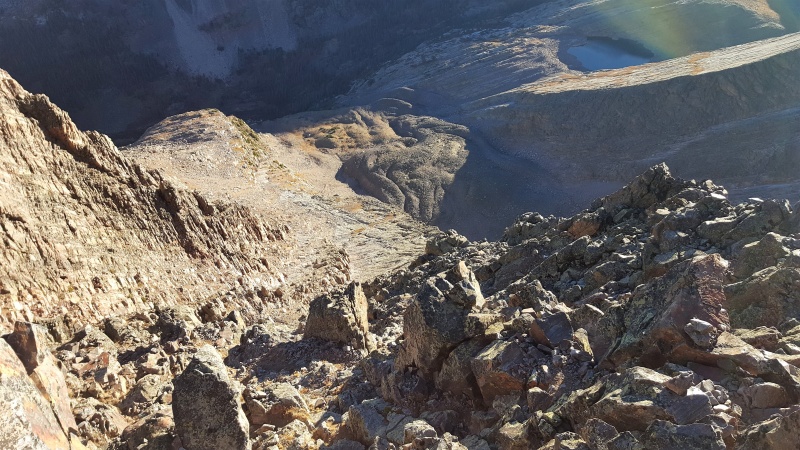
Topo lines got pretty tight near the bottom but I was able to piece together a path that didn't involve a parachute.
Cold mush in a bag spot #2
Next morning on the S ridge of Pk Seven. Just me and a Goat
Jagged getting in a few last days of sun tanning before the winter.
Getting off Seven along the Garratt and Martin route was as fun as smashing my fingers in a car door. Do yourself a favor and cut into the S ridge, it's Finger Lickin' Good.
Next up time to mob across Storm King, Silex and The Guardian.
Peaks and Valleys, Peaks and Valleys, Peaks and Valleys!
King for a day over the Vallecito Drainage
Pretty straight forward stuff tagging these 3 icons but when I busted out of Lake Silex I wasn't quite sure of my exit plan. Back tracking didn't seem too fun and I would probably run out of daylight again. I was ready to just sleep on top of one of these if I had to but spying down the S face of The Guardian it looked pretty chill. Once again, the topo lines bunched up near the bottom but there always seem to be a way. To my surprise, I stumbled into a very well burned in trail that shot off the dry creek bed I was following. It traversed to the east and then zig zagged its way under a 100 foot rock cliff. Sweet! That tee'd into a beautiful trail I've never seen on a map that followed the Leviathan Creek all the way down to the Vallicito Trail. Elk bugled from every corner, deer bounced their furry butts over fallen logs and Moose clobbered their way through the aspens while I dreamed of another cold baggie of mush coasting down this red carpet of a path. The next morning I got back to my bike and let sweet gravity pull me back to civilization. Another awesome trip that I didn't die on! Those are my favorite kind.
My GPS Tracks on Google Maps (made from a .GPX file upload):
Kansan, Glad you enjoyed the read! But to your comment, this was my report with Storm King. I just followed the standard route up and down and figured there was really nothing new to tell. But, for the record, Storm King was the windiest summit on my trip to live up to its name!
Thanks for the entertaining report. Impressive accomplishment. Did you have any issues on the bike ride to Kite Lake ? I planned to do this a couple weeks ago, but opted for a backup plan. It looked to me like it was a pretty gentle grade up until the crossing of the Rio Grande.
Relative to other pedal approaches I've done (S. Colony, Little Bear, all of Elbert, Wilson's, Yankee Boy Basin, Castle, Antero, Emerald, Princeton, Greys...) this one had the most easy and low grade miles by far. With a 4 day pack on my back I'm a lot quicker to concede to steep grades and just walk up pushing my bike knowing I'll be nuking down on the way back. The east side of Timber Hill is full of embedded rocks and is just steep enough to be just as quick pushing the bike up rather than fight to pedal for close to 1000 vert ft. The way down this section at the end of the trip was super fun but I'm on 2.5" tires with 160mm of travel. Any bike can make it down but with my setup I could mow over everything at full speed. Once you turn off of 520 heading to Kite Lake, the road remains predominately packed dirt and gradually gets steeper towards the lake, easy stuff for a mtb. I walked about a 1/4 of this stretch on the way in just being lazy knowing I had days of walking the earth ahead of me. You'd probably be faster overall in a worthy 4wd even though I'm sure a bike is quicker getting out of there. I'm just a total noob with my truck on the jeep roads and have a lot more fun on my bike.
is one of the most awesome things I've ever loaded into google earth
Caution: The information contained in this report may not be accurate and should not be the only resource used in preparation for your climb. Failure to have the necessary experience, physical conditioning, supplies or equipment can result in injury or death. 14ers.com and the author(s) of this report provide no warranties, either express or implied, that the information provided is accurate or reliable. By using the information provided, you agree to indemnify and hold harmless 14ers.com and the report author(s) with respect to any claims and demands against them, including any attorney fees and expenses. Please read the 14ers.com Safety and Disclaimer pages for more information.
Please respect private property: 14ers.com supports the rights of private landowners to determine how and by whom their land will be used. In Colorado, it is your responsibility to determine if land is private and to obtain the appropriate permission before entering the property.


")
")
")
")
")
")
")
")
")
")
")
")
")
