What Coloradoan hasn't looked at Lone Eagle Peak and thought "Man, I need to stand on top of that pointy-point of a summit." Plus, the route is called Solo Flight! (!!) We had entertained the plan for some time, but when Sean (Stee) was also free during a week when my amazing mom was in town to watch our kids AND there was a permit available...well, the die was cast.
I want to note that a year ago I had asked for advice on the difficulty of Solo Flight (Class 4 per Roach) on a forum post about a year ago, and had some good feedback...route finding is key, lots of exposure, etc. We did decide to bring a rope for a short rappel AND had one move that I'd call low fifth class (but we found could possibly be avoided after the fact), but otherwise I think that forum thread was pretty good insight. https://14ers.com/forum/viewtopic.php?t=52819
Trip Total: ~19 miles, 3750 feet elevation.
Day 1: Monarch Lake to Mirror Lake: 7.8 miles, 1,988 feet, 4 hours flat.
We left Denver around lunch, and started on the trail from Monarch Lake at about 2:30pm. This approach hike is high on our list for favorites in Colorado. Starting out from Monarch Lake the grade is mellow for the first 3-4 miles following Buchanan Creek & Cascade Creek as it winds along.

With a quick pace set by my wife, we hit Cascade Falls and took a leisurely break enjoying this incredible spot.


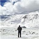
After the falls, the elevation gain picked up and the terrain began to open, and before long we began to have views of Apache, the Lone Eagle Cirque, and eventually Lone Eagle Peak itself. This place is jawdropping!


Once we arrived at Mirror lake, there were only a few other parties, so we scoped out the best camping site between Mirror and Crater lake, made dinner, and sat on the shore of Mirror Lake to eat and plan the next day. After dark and some star photography, we all settled in for a night of perfect mountain weather.
Day 2: Climb Lone Eagle Peak: 3.6 miles, 1750 feet, 6 hours (then 7.8 mile hike out in 3 hours).

We determined that getting back home in time to relieve childcare required an early start, but we also didn't want to get into the technical terrain when it was too dark. We settled on 4:30am start (with a ~6:15 sunrise).
After the alarm/caffeine/oatmeal, we geared up and set off. After crossing the boulder field on the shore of Crater lake, we began to ascend a relatively steep hill while hugging the cliffs on LEP's east flank.

This steep (and sometimes loose) route continued and wrapped around the peak, gaining notable elevation. We could tell we were moving deeper into the cirque, based on a high moon overhead, but didn't have much to see for the first hour or so.


Eventually we began to see hints of light and color above the rugged peaks, and could faintly see Triangle Lake, an upper alpine lake. What an incredible area!

About this time Roach instructs you to look for some black streaked cliffs (see the photo below) and turn into the mountain to begin ascending ledge systems. Mostly this was class 2, with the occasional easy class 3 move.


Eventually, you get to a notch to see through the rest of the route - and it looks incredible!!!! We spent a moment figuring exactly where to go from here, but eventually passed through the correct side of the notch, and were quickly greeted w a class 4 bulge, then exposed ledges.


Within 5-10 minutes of the notch, we reached the class 4 downclimb that our beta noted could be safer to rappel. Sean went ahead to check it out, and agreed that there were very narrow downsloping ledges for ~50-70 feet, and he built an anchor. The most direct route to this rap spot involved a step around bulge w poor hands that I think is 5.something, but definitely got some adrenaline flowing and was the crux of the route for me. I put the camera away so don't have a photo...On our way back we determined that you could probably go higher to avoid this move. Regardless, I'm super thankful Sean was there for a safe option setting up the rappel.


From here, the route was 100% pure fun! We traversed along a few more narrow ledges...

...then began moving up an awesome system of flakes and cracks. It was highly exposed, but there were always great hands and feet available.


Then we topped out! The summit has a narrow catwalk out to the pinnacle, which is about as tiny as you can get. I don't get heebiejeebies very often from exposure, but it's a pretty sheer drop over the sides, so we took turns heading out to stand on on that point!
 My wife on top.
 The view from the pinnacle.
 Looking back along the catwalk.
 The victorious crew!
The descent reinforced the airy nature of the route...the rock is solid, but there is a lot of no-fall zone.


We had left the rope from our rappel to protect the climb back up through that section. 
Then it was back across the upper mountain...

Through the notch...

We got to see views of the cirque that had been in the dark, including the emerald colored Triangle Lake...

Eventually we were back on the trail hugging the cliffs, where we also saw signs of Autumn were beginning to show.


And finally through the boulder field abover crater lake. We realized there was a cairned trail far to skiers right from where we ascended, though it didn't seem particularly different. 
And with that, we returned to camp, packed up, and hoofed it out to the cars 8 miles away.
This was a phenomenal trip, with perfect conditions and no notable hiccups. Having done Pyramid the day before, it is hard to see how they can both reasonably be called class 4 in our opinion: Pyramid was basically a Class 3 with maybe a hair more exposure, while Lone Eagle was a significant step up in high consequence terrain, though the rock was generally solid and it was a relatively short route.
")
")
")
")
")
")
")
")
")
")
")
")
")
")
")
")
")
")
")
")
")
")
")
")
")
")
")
")
")
")
")
")
")
")
")
")
")
")
")
")
")
")
")
")
")
")
")
")
")