| Report Type | Full |
| Peak(s) |
Pico Aislado - 13,621 feet Tijeras Peak - 13,612 feet Milwaukee Peak - 13,526 feet Cleveland Peak - 13,404 feet Unnamed 13403 - 13,403 feet Unnamed 13392 - 13,392 feet "Dead Man Peak" - 13,048 feet Unnamed 13028 - 13,028 feet |
| Date Posted | 09/05/2018 |
| Date Climbed | 08/24/2018 |
| Author | Chicago Transplant |
| Sand Creek Lakes Eight Pack: A Sangre 13er Finisher Story |
|---|
|
Sand Creek Lakes Eight Pack: A Sangre 13er Finisher Story Peaks climbed (in chronological order) Tijeras Peak (13,604'): 189th Highest - 8/24/18 PT 13401 (13,401'): 268th Highest - 8/25/18 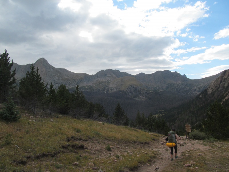 Introduction There are 73 ranked thirteeners in the Sangre de Cristo range of Colorado, another 10 Colorado fourteeners, and 3 more ranked New Mexico thirteeners. I can't remember what my first thirteener in the range was, but it was likely Huerfano after climbing Lindsey. I do remember what my first fourteener in the range was, Challenger Point. I had only lived in Colorado about 14 months at the time and had decided I needed to get into the ranges that were a little farther drive from home if I was ever going to finish what at the time was a list of the Highest 100. We packed in to Willow Lake on a Saturday afternoon in August of 2005, it was myself, a co-worker and his future wife and a second co-worker. We had a great time cooking up dinner at camp, checking out the waterfall at the lake, and enjoying the rugged scenery. The next morning we did not ascend the standard route, instead opting for a route much farther right then across the backside of the ridge. A lot more third class scrambling than the standard and none of the loose rock that the standard holds. Instead it was Crestone Conglomerate and got some of us excited at the prospect of a future trip to traverse the Crestones (which I and one of my partners from this trip got to do in 2007). Kit Carson didn't make it for this trip, but we had a great time. It introduced me to the unique character of the Sangres, a long narrow range trending generally north-south with wide low valleys on either side. The views go on and on, not surprising as you can see so many of the Sangre peaks from distance. At the time the full 13er list wasn't something I had given much thought to, certainly not committed to. So as we move ahead to 14 years later, having finished all but 8 of the ranked peaks above 13k in the range (including in NM), there are many memorable trips, some with grassy ridge runs, others with 3rd class scrambles, or a mix. Day trips, backpacks, jeep roads, small towns, wildflowers, fall color, fresh snow, sand dunes, Wilderness, private ranches - the range has had it all. So it seemed fitting to end as it had begun in a sense - in sight of the Crestones on a backpacking trip with some great third class scrambling. Good weather and a multi-day trip were required, and we were happy our vacation days aligned so well with a good weather window for these long committing ridge runs. Our pack-in was not going to be too long, even from the 2WD trailhead, so we didn't need to rush in the morning. We had time to pack, go over our routes, buy food and stop in Buena Vista for a delicious lunch. By the time we got to the trailhead to pack in it was nearly 4pm. Still some last minute packing before we hit the trail from a little ways above the Grape Creek trailhead before the rocky road steepened out of my comfort zone. Might be able to get an Outback up this road, but we didn't want to. It was only about a 6 mile pack in with maybe 2600 vertical feet, though driving to the upper trailhead would shorten that to more like 3 miles and 1150'. We set off around 4, crested Music Pass at 5.20 and were at the lake by 6.30 looking for a place to camp. We started up the Tijeras climbers trail and found a bench above the lake that would serve us nicely at about 11,500. There are other options closer to the Cleveland approach as well, but most of the camping at the lake is too close to the water (must be 300' away), although it doesn't seem to stop people. You could also camp near the trail split for the lake off the main Sand Creek trail, which would be a nice base camp as well. Upper Sand Creek Lake has camping too, but does not set up well for Cleveland. The nearly full Sturgeon Moon gave a great ambience, even if it did keep the tent a little too bright. 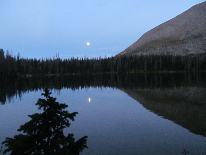 Day One: Tijeras to PT 13020 - Friday August 24, 2018 Approximately 12 miles and 7000 vertical feet Friday's weather was forecast to be perfect, barely even any clouds and no moisture. We knew we had a lot of vertical with 3 big climbs planned, so we wanted an early start anyway, but bushwhacking in the dark is not our idea of fun either. We left camp about 6am and were able to do a decent job following the climbers trail to treeline. We had been up it part way once before (for Music last year) and knew it was a reasonable trail. At treeline it fizzled out and we found a steep grassy slope with some willows to get below the base of Tijeras' signature cliff band. This cliff band cuts across the whole base of the peak and ties into Music Mountain's east face. There are only 2 reasonable breaks that provide passage to the upper mountain. We chose the lower (left) of the two, which was a pretty obvious weakness. 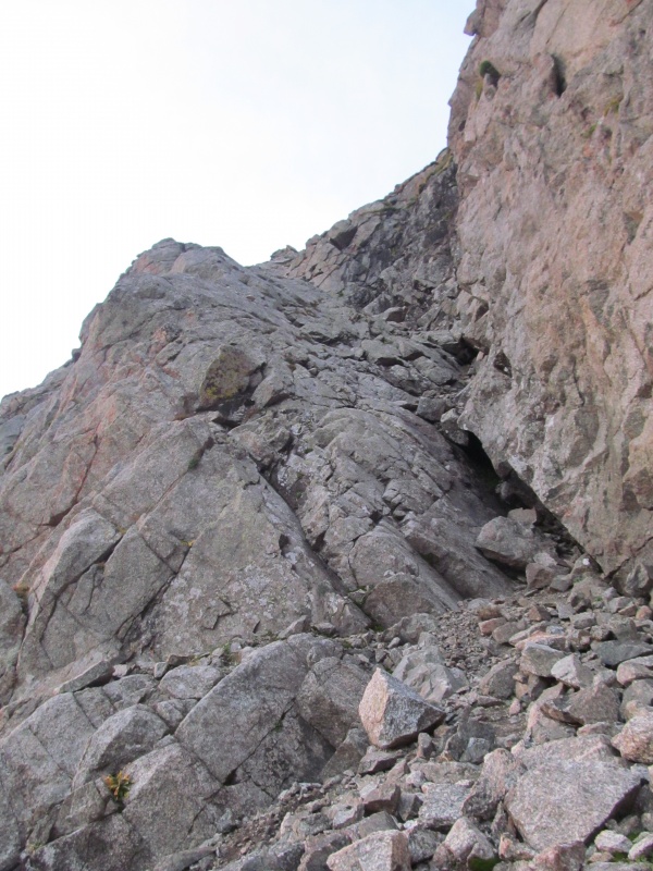 The bottom was the steepest part, a slab with a few stiffer class 3 moves. There is even an old sling at the top of this slab, and it could be a challenging down climb. The slab relents a bit after this and is really fun scrambling. From above the slab there is a mix of class 3 and steep grass that gets you the rest of the way through the cliff band. 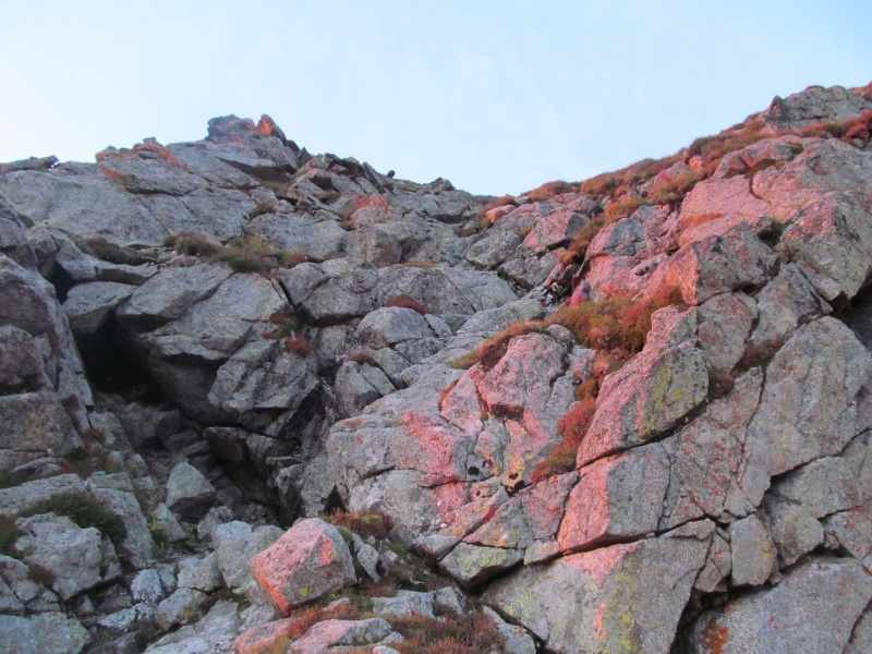 If you are retracing this route for your descent, pay close attention to where you are as the peak is non-descript from above. We followed steep grass slopes to the ridge crest and tried to stay as close to the crest as possible. 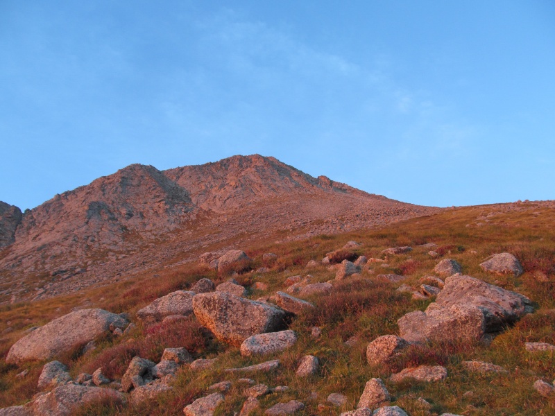 This involved mostly easy scrambling with one harder move right at the backside of a false summit. We were on the summit in only 67 minutes from camp, and feeling good about our day. Tijeras is a great peak, with a striking profile, fun scrambling and great views. 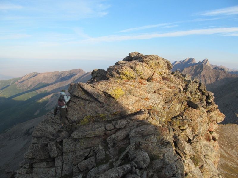 Our pre-trip research had us looking for a way to combine Tijeras with Milwaukee. For one, the standard ledge traverse on Milwaukee is incredibly exposed, but also because our forecast research made it look like Sunday morning was going to be wet and we worried we would not be able to sneak Tijeras in before a pack out if it was. Better to take advantage of the good weather day and hike them all together in our opinion. Looking at topos and photos from other trip reports and our Music hike we were 95% confident we found a grassy descent off the Tijeras Music saddle to the west that we could then wrap around Music's west side and up Milwaukee's class 2 southwest slopes. 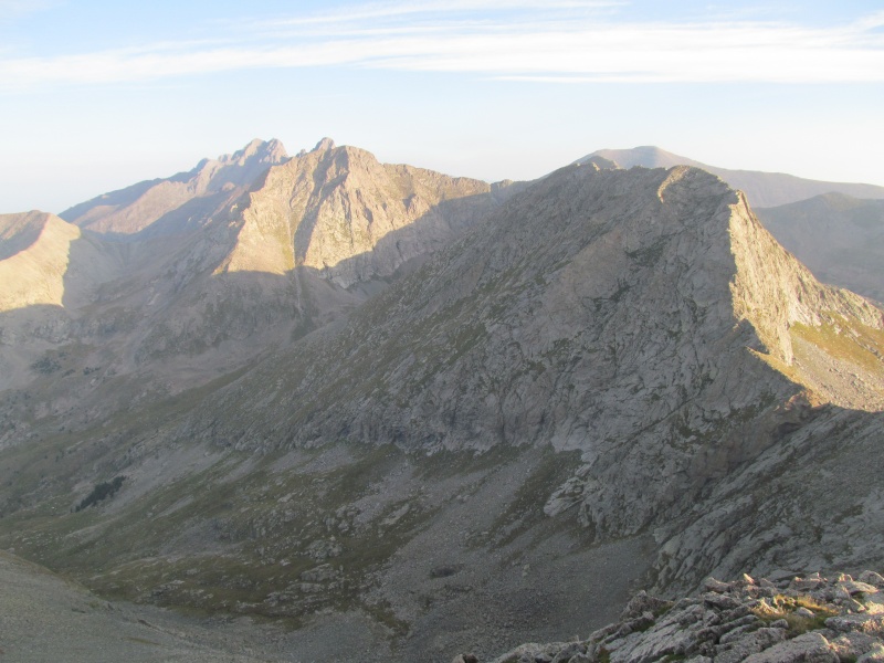 We were able to see our planned route from the ridge on our way, and as we reached the saddle found our intended grass gully just above the saddle. It was steep, but almost all grass the entire way down where we then contoured along the base of a long cliff below Music's west side. 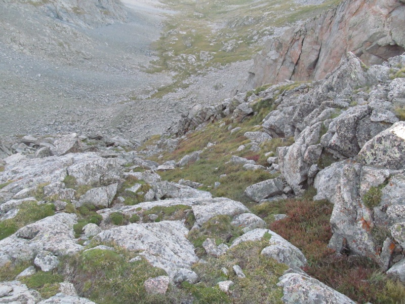 Earlier we thought we could scramble up above it towards the end and save some elevation loss, we probably scrambled up a little too early as we had a few class 4 moves. Our low point was about 12,200. We then contoured high around the corner where grassy ledges would bring us high into the basin between Music, Milwaukee and Aislado. The route finding was not too hard here, but we did have to lose a little of the elevation we had gained back before clearing all of the difficulties and working our way up to the base of Milwaukee. 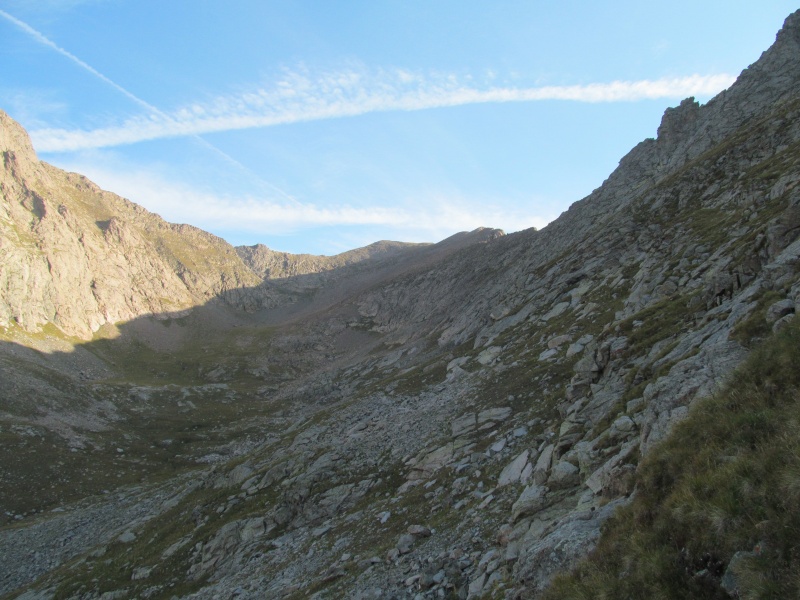 The slopes steepened and we trudged on up to the south ridge above the saddle with Music. Some easy class 2+ terrain led us to the summit. 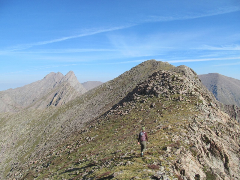 We reached the summit at about 9.10am where we were greeted with some more spectacular views, and were able to look down on the Milwaukee (aka Cottonwood) Pass trail below, our future exit. Our plan to combine Tijeras and Milwaukee went really well and is a good alternate to the exposed ledge of Milwaukee's standard route (more on that later).  After about a 15-20 minute break it was now time to take on Pico Aislado. Spanish for "Isolated" it certainly feels like an appropriate name. First we need to descend off the west side of Milwaukee, which is a quick easy descent of a rock and grass ridge to the 13,220 foot saddle where Pico's difficulties start to present themselves in an imposing fashion. 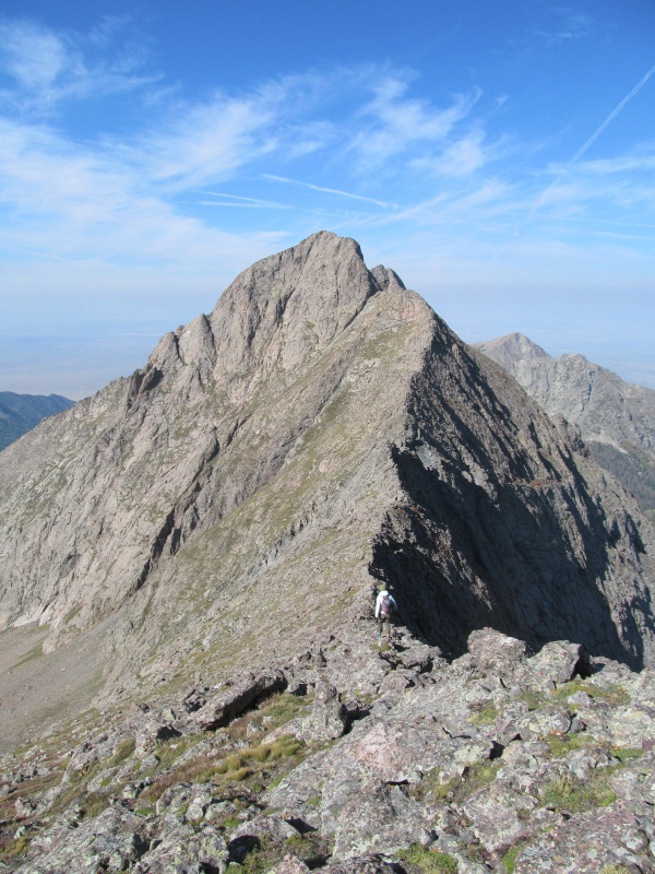 At first you wonder how to even climb the east face but as we study it from our ridge perch a few options start to open up and we come up with a game plan. 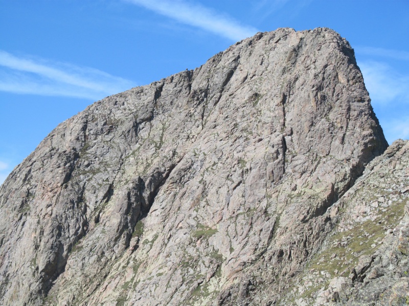 First we have to drop off the ridge a little ways to the left to avoid a rocky tower, this puts us at the base of the face with a few grassy options above us. We first start up the slope immediately in front of us to a big grassy ledge, thinking we may be able to find a ramp above. This may be true, but a stiff rock step is above us that we don't want to have to climb back down if we dead end. We descend slightly off the big grassy bench and traverse over to where two prominent gullies split a steep face. The left looks easier, but the right is closer and we start up it with class 3 scrambling on grassy ledges. 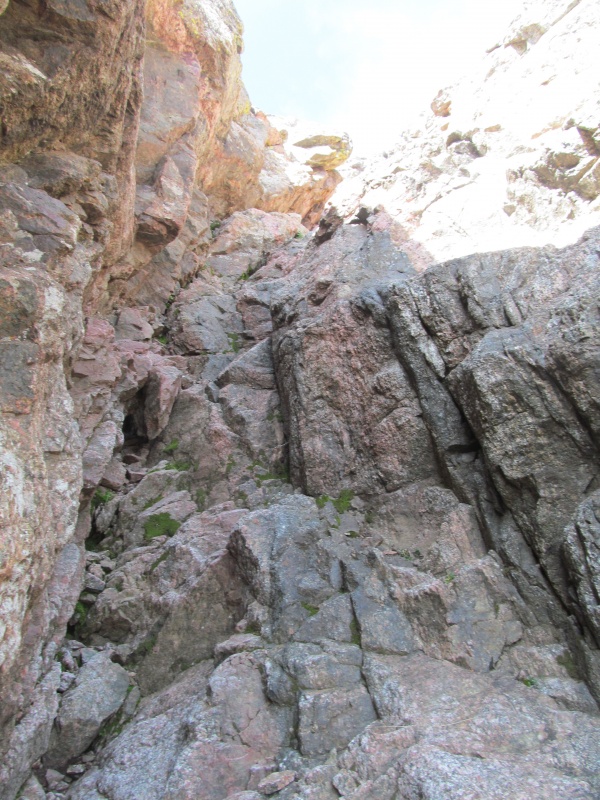 Rachael is in front and keeps going up and up the steep narrow gully. We pass a point where we could exit left, but stay in the right gully. Now the gully is narrower and steeper, and some class 4 is required. About halfway between this exit point and the summit ridge it gets really tight, with the left wall overhanging the gully in a squeeze with a little bit of looser rock. 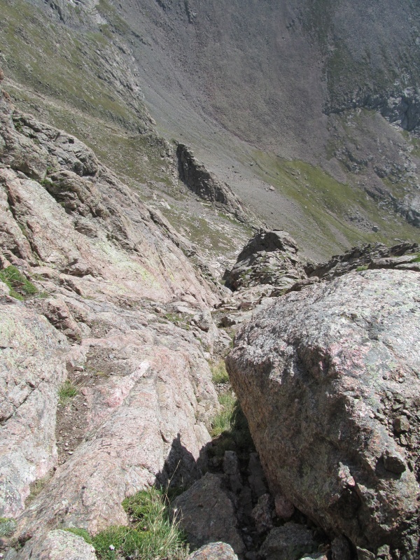 Rachael is in front and some small rocks trickle down. As the gully reaches a constriction, she has to take her pack off, and she is only 5'-2". As I follow I have to move out to the right, where the rock is more solid but also less holds and more exposed, class 4 and slabby. 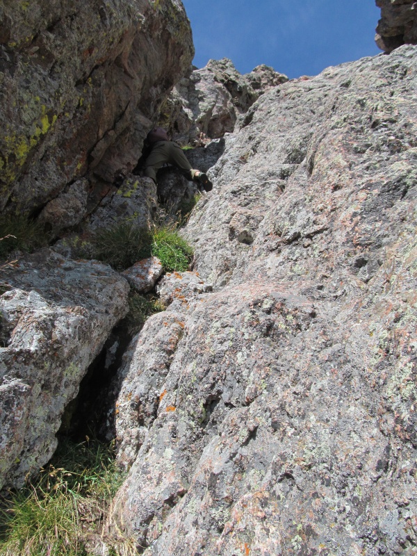 Trying to stay left to help grab Rachael's pack proves tight, but I manage to get her pack back up to her before exiting the constriction on the exposed class 4 slabs. Rachael needs to exit to these slabs as well but after maybe 10 feet it relents to a pocket and easier scrambling to the ridge crest is found. We top out on the ridge maybe 5 feet from the summit, an aesthetic nearly direct line! A very cool route, we think this is the gully referred to as "The Wedgie" by Kevin Baker. We also think this is the route described in Cooper's book, if we would have went up the left side gully, it would have been easier. The entire gully scramble took about 15 minutes from when we entered it to topping out on the summit, but felt longer. Great views of the Crestones from the top! We were proud of ourselves for sticking with the harder, more aesthetic gully, but also glad we didn't need to down climb it. 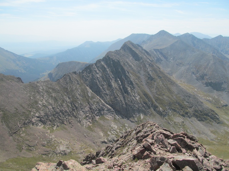 The technical difficulties now all behind us, we can let our guard down a little, but its still a long way to camp, with another 13er and an approximately 1600' reclimb. Descending the west ridge of Aislado starts with a short rock traverse, then a steep gully avoids the difficulties of the ridge on their left side. If you hug the right side of the gully you can stick to mostly grass, and make reasonable work of the 950 feet of elevation loss to the saddle with PT 13020. 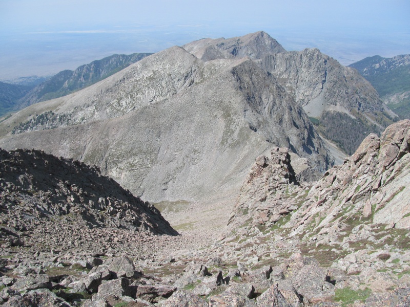 The view down the right side is awe inspiring and reveals no passable way to the basin below. There is also an impressive thumb of rock coming off the NW side of Aislado that we dubbed El Pulgar de Aislado (Thumb of Isolation), definitely 5th class. 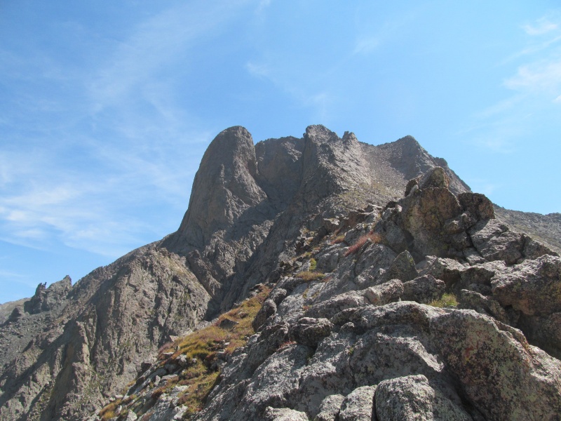 The next 13er is just a quick class 2 jaunt, in fact we didn't even know we summited, as we thought the false summit to the west looked higher. Incidentally, that ended up being where we took our "summit" break, and briefly contemplated tacking on the 12er to its west. We decided not to, if we really wanted that 12er some day we could get it from Cottonwood TH, for now we didn't want to get stuck on the wrong side of the pass from our camp. 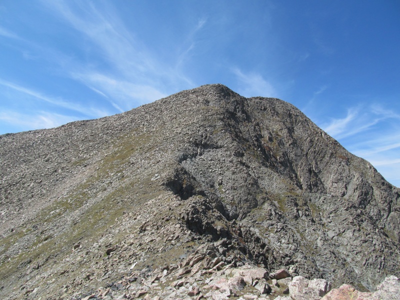 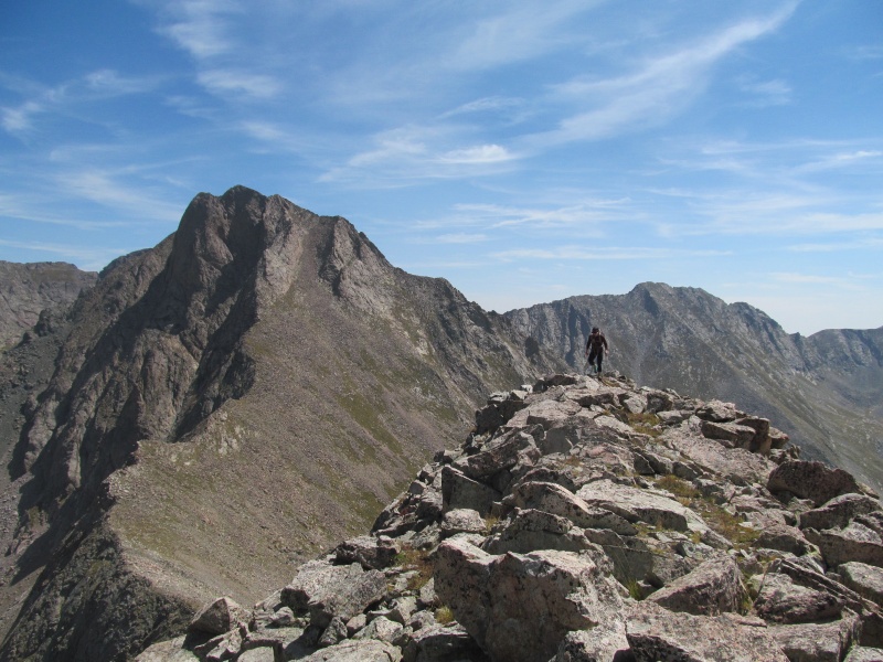 We had a pretty good view back towards Tijeras and the route we used to get to Milwaukee around the backside of Music. This image gives a good look if one was interested in repeating our route: 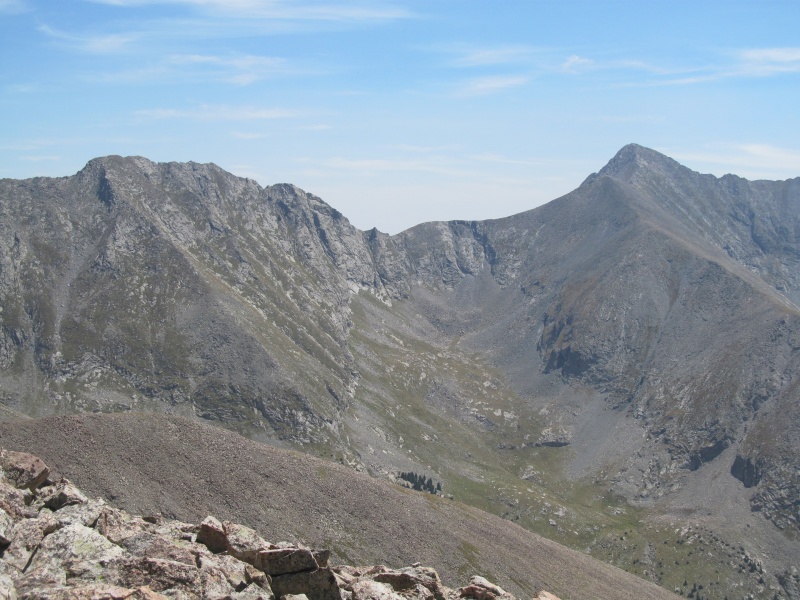 Pretty good views of the Crestones too: 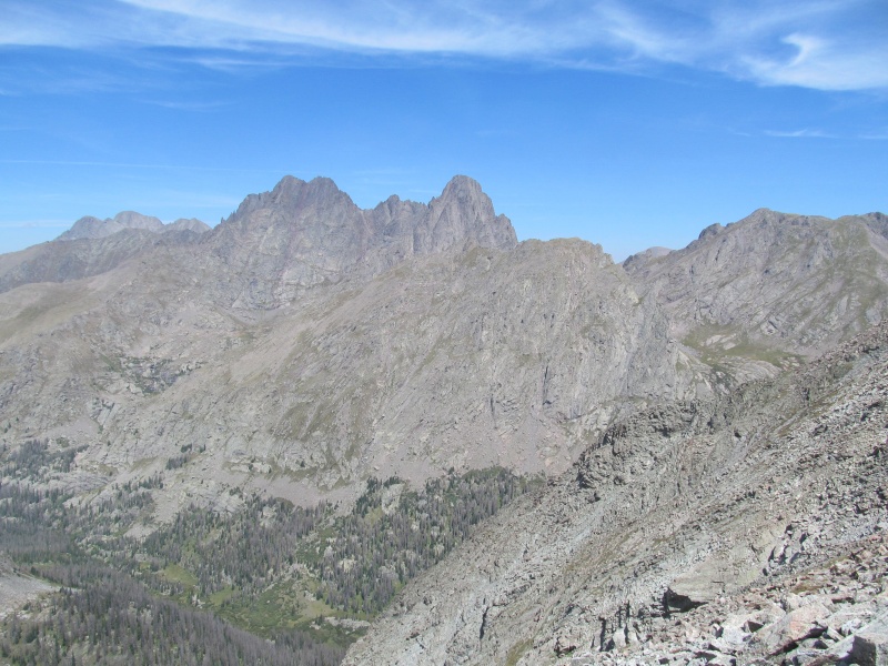 From the false summit we made our plan of attack on our descent to Cottonwood. There are no reasonable bail options to the Cottonwood drainage until after you summit, but the views down the wall are cool. From the saddle on the back side of the false summit we contoured across a mostly grass slope until we came to a grass ramp that we could use to descend most of the way to a small lake below us. This cut out a lot of loose talus and made what is a notoriously awful descent only half awful. 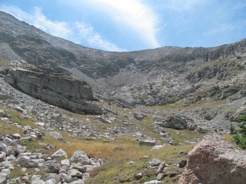 Finishing our descent on loose rock, we took a short break at the lake admiring the views. There is a reasonable campsite here as well with a good view of Crestones! From the lake we tried to stay high, the lake is about 11,800, and I think we managed to only drop about 100-150 feet below it. We didn't even bother trying to find the trail in the woods, we just stayed high aiming for a long flat meadow labeled "spring" on the topo map where we topped off water bottles from the creek (we packed our filter in lieu of extra water). 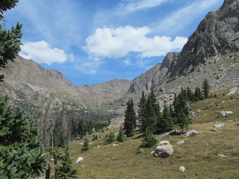 Once we exited the meadow the going got tedious as we were climbing a mix of grass and rock off trail towards the head of the basin searching for the switchbacking trail that leads back over to Sand Creek. Eventually we got to the gully we had earlier spied the trail going up and just started going straight up hoping to intersect the trail, which we fortunately did sooner rather than later. In an instant our mood changed and our energy increased. Even an overgrown trail such as this felt like a blessing to our tired legs, its amazing what switchbacks can do for your calves. The trail is spectacular, while yes its overgrown, its not that hard to follow most of the time as the cut marks of the trail are easy to discern. Every time it seems headed for a cliff, it makes a switchback and finds a way, all the while with ever increasing views of the Crestones and Aislado that just won't stop getting better. 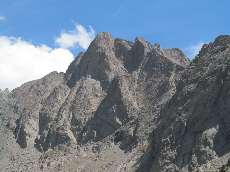 We spy a crack up El Pulgar de Aislado and wonder if anyone has ever climbed it (we definitely won't be the first). Then we finish the traverse of the last section of trail to the pass where we get to see in person the infamous exposed ledge of Milwaukee. 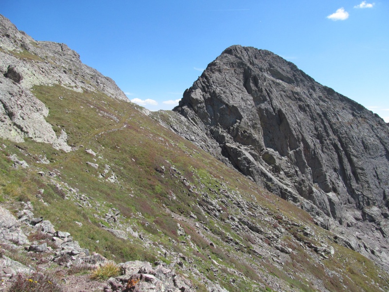 The notch that is used to get into it is only a few feet from the trail, and looks fiercely committing. While likely only class 4 tops, its a long way down if you were to fall. We decided not to explore it any farther, but do manage to get some pics that give a sense of the exposure! It makes the ledge on Pyramid look like a paved super highway. 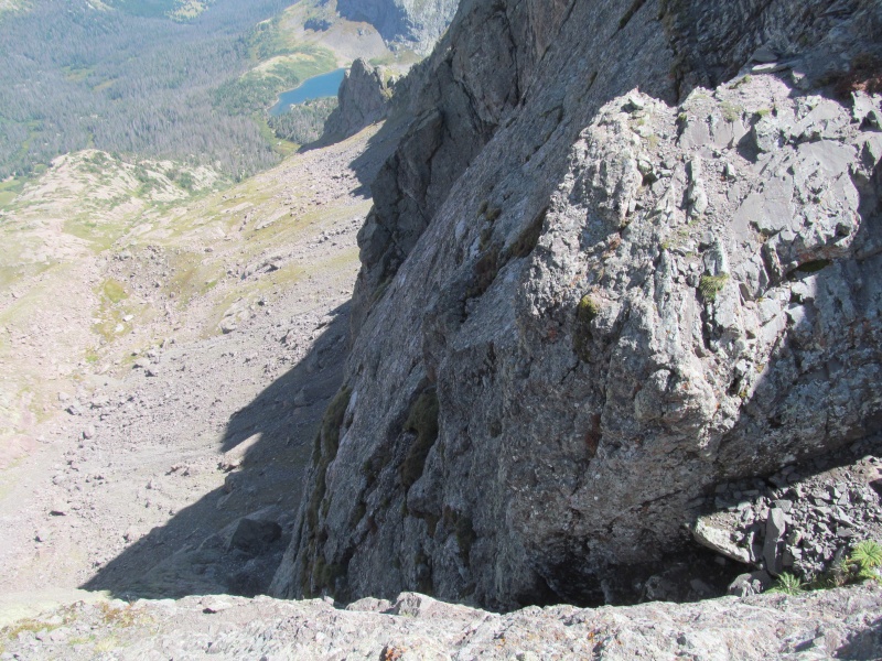 The trail on the Sand Creek side continues to impress, and we wonder who built this trail? Its almost a shame it sees such little use, but then again, that may be why its so cool. As it flirts with the ridge crest you get to peer down into South Colony and marvel at the Ellingwood Arete in profile. 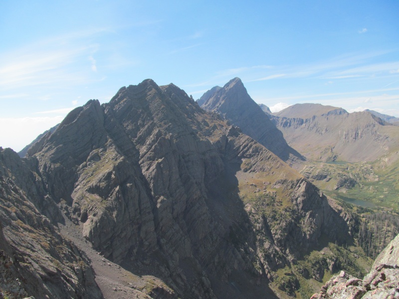 Then like that it disappears at a saddle where a sign says "follow cairns", sure enough a series of cairns lead down the grass below and eventually the trail picks back up in a grassy avenue between cliffs. This transitions to a wide grass ledge that cuts across a cliff face with views of a meadow below. Here the trail is at its strongest as it cuts through the forest, and its a good thing too because we don't want to be bushwhacking. We pass the turn off for Upper Sand Creek Lake, then in another half mile or so our turnoff for Lower Sand Creek Lake and the 400 foot climb up the switchbacking trail back to camp. Glad to be back at our temporary home, we rest, snack and later enjoy our dinner. We have the entire lake to ourselves. Day Two: Cleveland Group - Saturday August 25, 2018 Approximately 9 miles and 5800 vertical feet We woke up a little earlier Saturday, the forecast when we packed in still looked good but did have a 20% chance of storms after noon and we wanted do be back off the ridges before any of that came to fruition, so we left camp around 5.30am and followed climbers trails around the lake to the southwest side. We had spied a grass gully next to a waterfall that looked like a good route to avoid bushwhacking, and the climbers trail actually got us all the way there, although in the dark we ended up crossing the creek a little higher than we wanted to. We went up the steep grassy gully then had to do some zig zagging around some willows and trees to finally get into open country in the basin south of Tijeras. From the summit of Tijeras the day before we saw the secret gully that leads to the summit ridge and avoids climbing over an additional unranked summit. 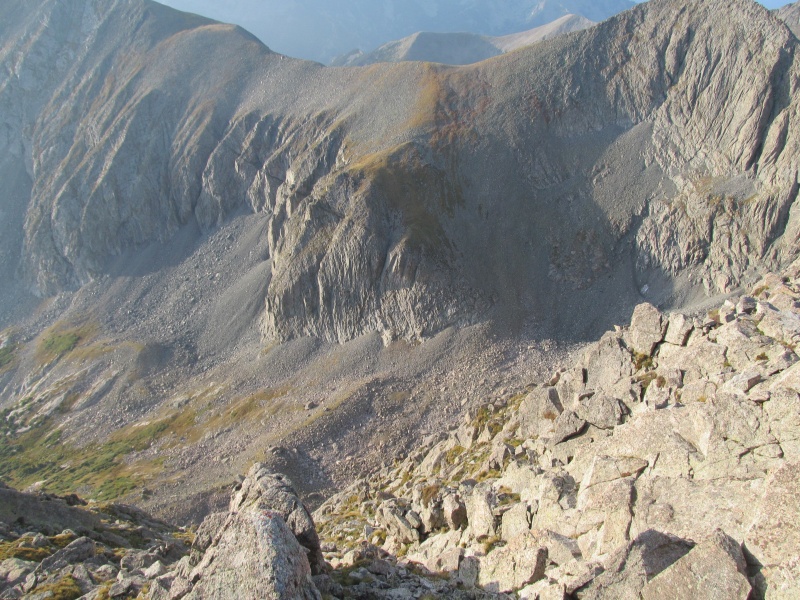 The terrain got rockier and a little unstable, but we were able to pick up a bit of climbers trail as we rounded the last cliff and found our gully, the climbers trail got us to the grass at about 12,800 where a short steep 300 foot or so ascent brought us to the shoulder of false PT 13495. This false summit of Tijeras is almost 100 feet taller than our first peak, but can happily be traversed on its left side without much elevation gain or loss to the 13100 saddle on the opposite side where the ascent of the north ridge of PT 13401 begins. 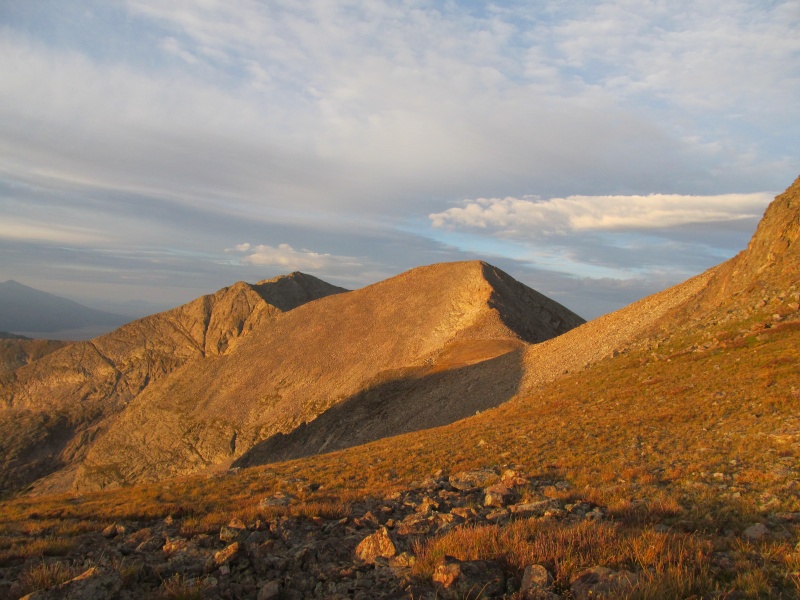 The north ridge first goes over a small false summit with a short interesting knife section that is easy to scramble with not much exposure. Then the ridge up the main peak is mostly class 2 with a few easy scrambling sections along the way to the high point of our first summit, at about 7.20am. Its a fun peak, which is great because we have to climb it again on our way out. 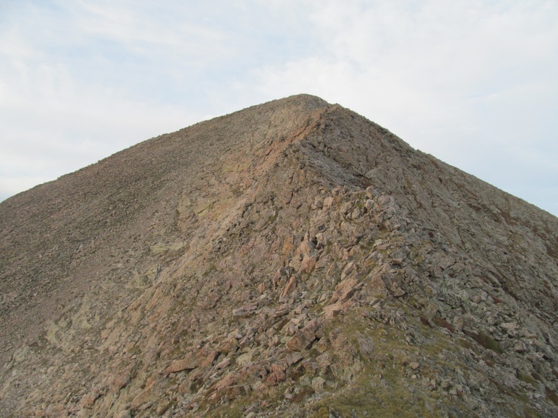 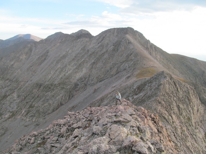 We begin the descent to the saddle with Cleveland, which is mostly class 2 and generally on solid rock or grass until the notch at the saddle. At this point a short cliff blocks easy passage but there is a loose gully we can switchback down to reach the saddle. Exiting on the Cleveland side has a few class 3 moves, as does much of Cleveland's ridge. 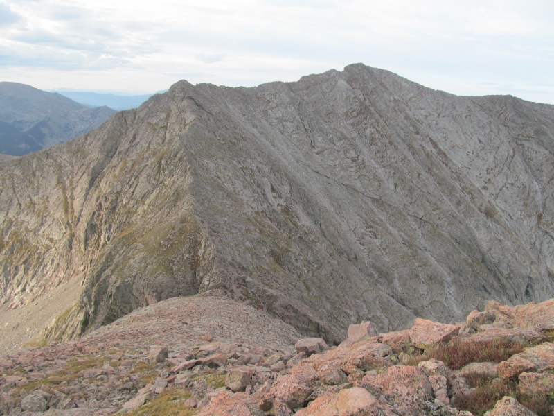 The ridge crest is generally the best way to go, either on it or within a few feet below to either side. In the spots you need to drop, you traverse wide rock ledges where you can use the ridge crest as a sort of handrail and the climbing is enjoyable. One spot before the false summit we need to drop a little farther, but find cairns here and the route is pretty clear. After the false summit the ridge flattens, but the scrambling remains. 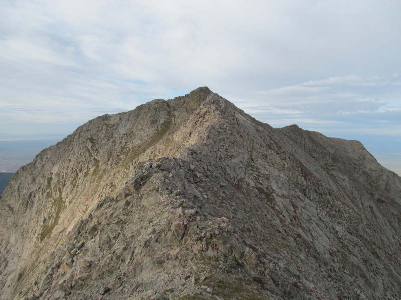 Much the same as the lower ridge, staying generally on the crest until just before the summit where a steep step rears in front of us. We find a grassy slope to drop maybe 20 feet and then climb up grassy class 3 ledges on the right (west) to regain the ridge near the summit. 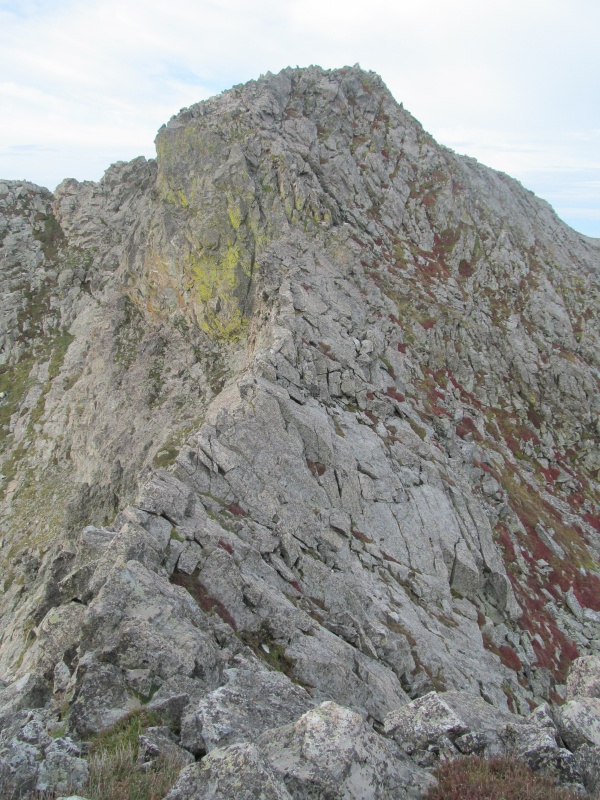 The 4 peaks on our plate for today make a sort of "Y", and we are now at the point in the middle. I had hoped to be here at 8am, and we were close, about 8.10. My thought was 1 hour to each of the remaining summits and back, putting us back on PT 13401 by noon at the latest. There are clouds but nothing threatening, but enough that Rachael didn't want to feel chased by them all morning so she decided to head back to camp solo while I went on. We part after a short break. 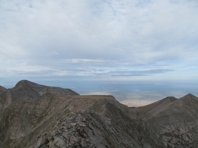 The ridge off Cleveland heads to a large flat area at about 13,200 that others have dubbed "The Punting Green", and the descent to this large flat plateau is quick with some easy scrambling, again mostly directly on the ridge crest. From "The Punting Green" the descent to the saddle with "Dead Man Peak" starts out with a little route finding to find a loose gully that avoids a step in the ridge. 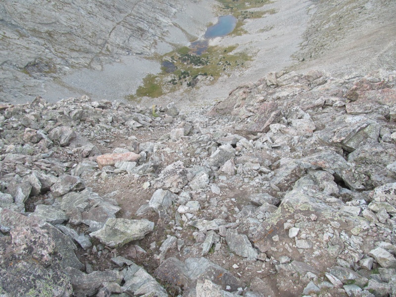 Once below that point you stay on the ridge crest the entire way to the saddle, and up the other side. Its a long drop as the saddle is at 12,660'. 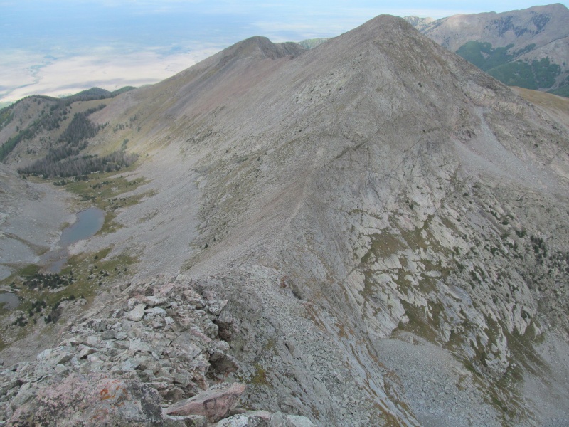 The 390' of vertical to the summit is not that bad though, and the terrain is easy traveling. In the distant valley below I hear coyotes howling. 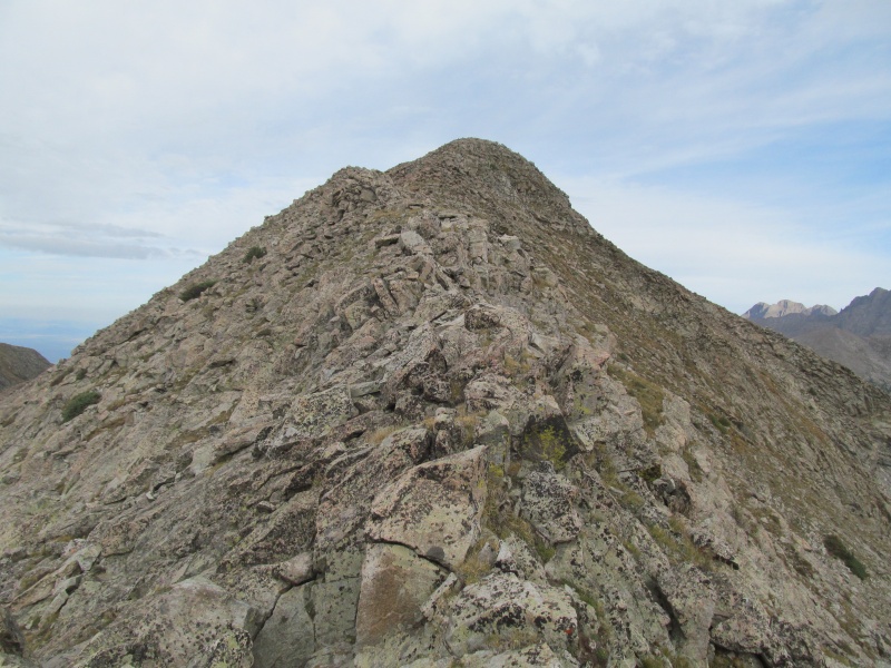 My 9am target was easily met and I am on my way down off the summit at 8.55am. It feels like a long reclimb to "The Punting Green", the last steep loose part the most trying. 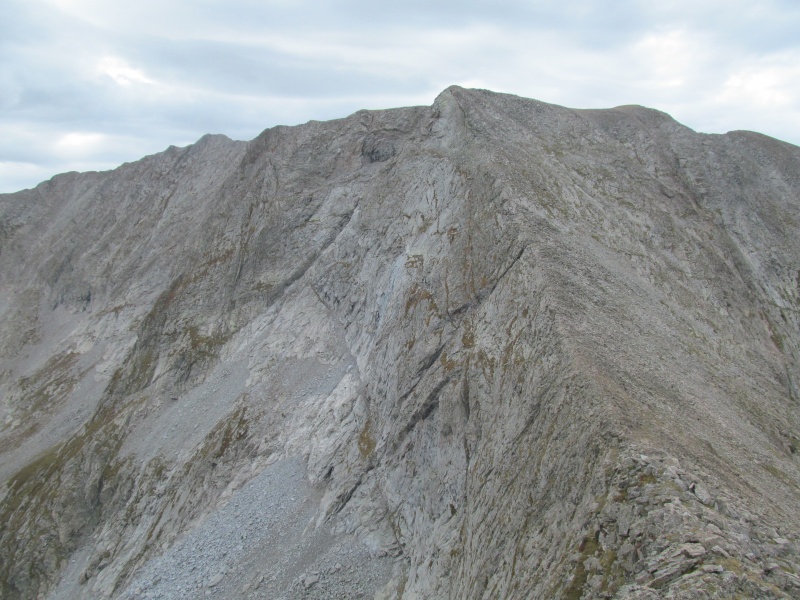 From there to PT 13384 is more involved than it first looks. First, you have a short up climb off "The Punting Green", then a 3rd class downclimb before another small tower has to be climbed. 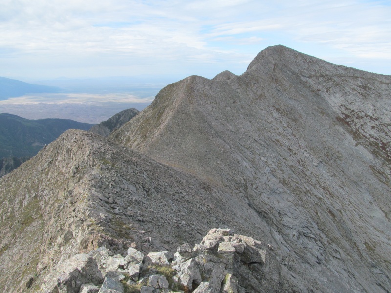 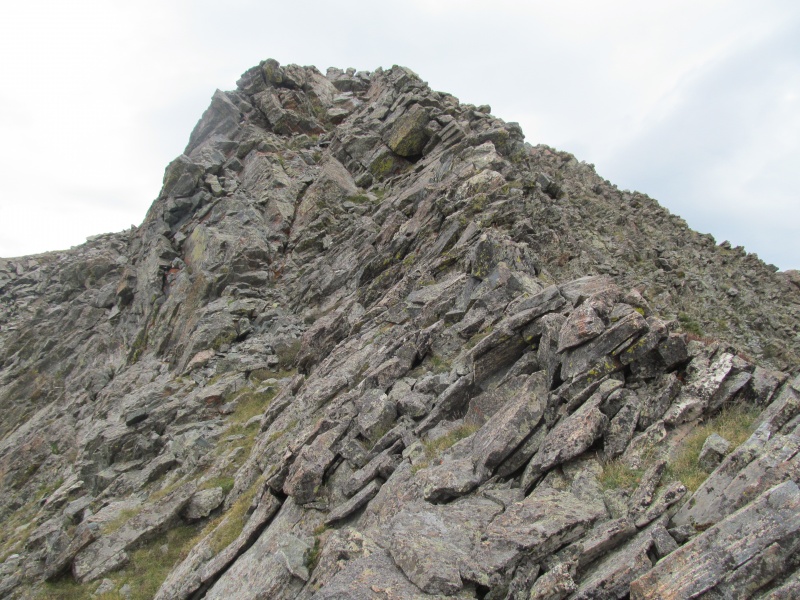 Finally you get to descend to the Cleveland - PT 13384 saddle, where of course the climb on the other side involves a false summit at about 13,200. All that work and I am only back to the elevation of "The Punting Green" once again. At least the remaining 3rd class ridge is a fun one. 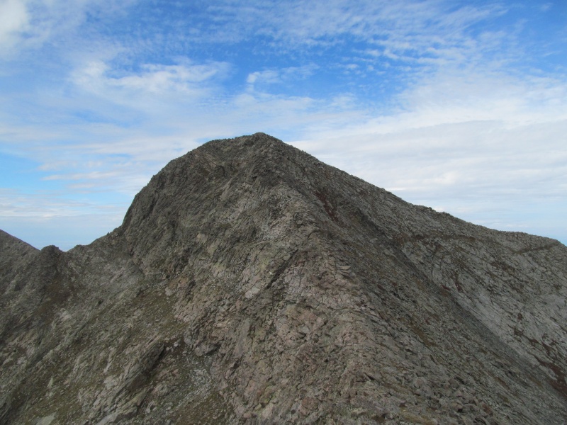 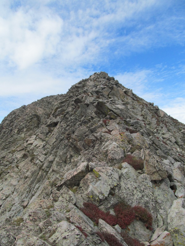 I top out on my last Sangre 13er before 10am, making great time. Its nice to be a little early so I can take a few minutes to admire the view and the accomplishment. Some water, a quick snack, and time to soak in the panorama. I don't dwell much on the accomplishment, after all I do have to reclimb 2 peaks just to get back to camp. It does feel good though, with a list as large as the 13ers (584), you revel in the smaller completions along the way, finishing all of them in a certain wilderness area, or county, or overall range. This peak hits all three of those marks. It feels like a good peak to finish the Sangres on, maybe not quite the quintessential Sangre peak, but it has a lot of what makes the range interesting. 3rd class on good rock, grassy ledges below, a view of the Crestones - and of the Sand Dunes. It feels good to be here, but when it hits 10am I am back on schedule and start my way down. 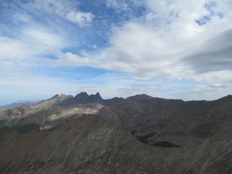 Reclimbing the little bumps between PT 13384 and Cleveland I start to feel it in my legs, but I make good time. I wanted to be on Cleveland by 11, I cross it at 10.45. I wanted to be on PT 13401 by 11.30, I cross it at 11.11. I wanted to be a top the final descent slope off the ridge by noon, but its only 11.35. The reclimbs were fun, the scrambling just as enjoyable in reverse, but the familiarity made the route finding go much quicker. I start down the grass slope and as I get to the climbers trail in the rocks feel a few faint drops of rain, its 11.50am and I am happy to be entering the basin. 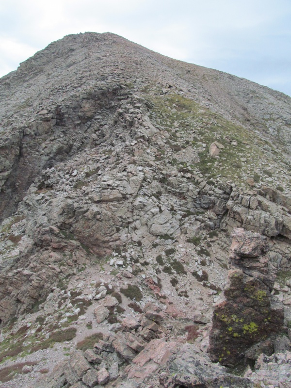 I think of Rachael back in camp and hope she is not worrying about me thinking I am up on the wet ridges above. I could use a water break after my retrace so I stop to finish off the water I am carrying and press on to treeline. Great views of Tijeras towering above the basin from the ridge above: 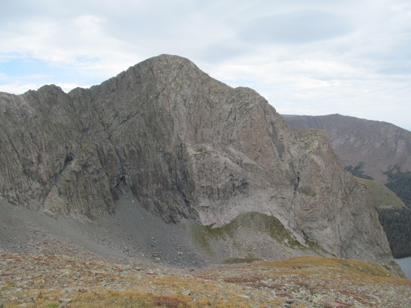 My descent goes a slightly different way, farther towards Tijeras, than where we came up the basin. I manage to find grassy slopes that eventually link back with the steep grass by the waterfall that we used on our ascent. A little bit of willow bushwhacking is required to string them all together, but its not too bad. 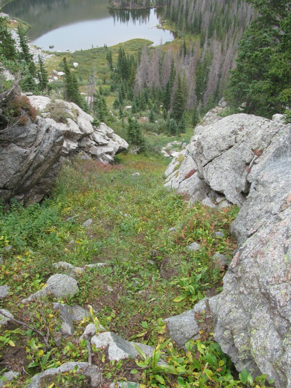 I stop by the waterfall to filter a full bottle, then pick up the climbers trail and make it back to camp before 1 where Rachael and I enjoy a snack. It starts to rain again, so we climb in the tent, she naps, I watch the flies caught under the rain fly. When the rain stops we have our lunch and talk about packing out this afternoon rather than spending another night in the tent. The rain stops, the sun dries our tent, and at 4pm we pack it up and out. We had the valley to ourselves our whole trip, but on our exit we see other campers coming in, and a few archery hunters as today is the first day of bow season. As we hike down the road we are already talking about what to climb on Sunday, and hoping we can get some service in town to check the weather. Before we left, Sunday looked like a wet day. Perhaps it will be a rest day for us instead? We still have Monday as part of our vacation too. The road is dusty, the footing unstable. After all that ridge running either my legs just are too weak, or I let my guard down. I completely wipe out, unable to catch myself before crashing down on my knees and elbows with the awkward weight of the backpacking pack almost rolling me over. Seriously? Can't even hike a road, how the heck did I ever climb all the Sangre 13ers? At least there are more snacks waiting for us in the car. Sunday does turn into a rest day, a lazy morning in camp then lunch in Westcliffe. Monday we take a break from my 13er list and pick up a new 14er for Rachael - Mt Lindsey via the ridge route. The wind is biting and it feels like fall is coming, but we are happy to have a successful summit and another fun trip to the Sangres. It won't be the last! Happy trails, thanks for reading. 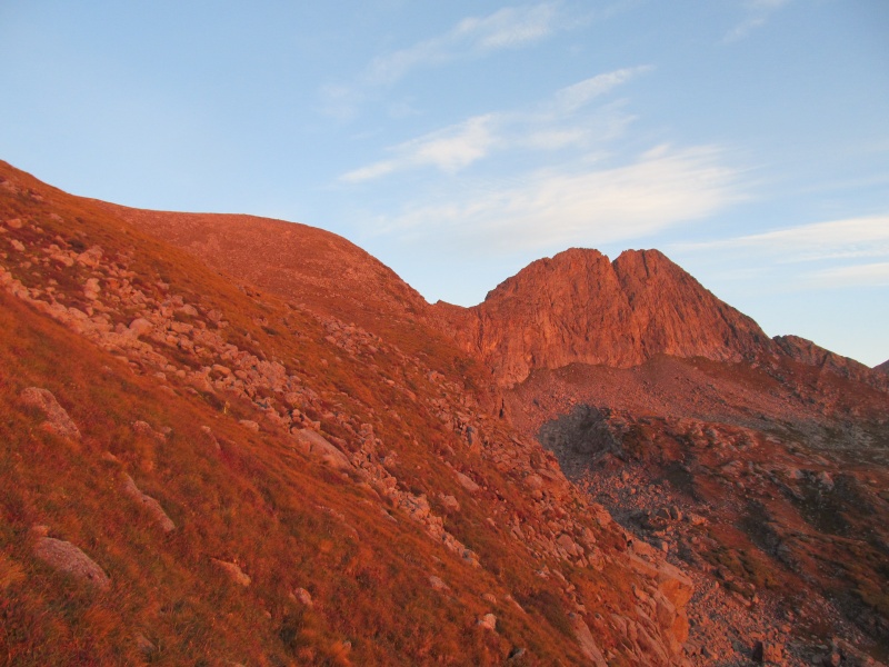 Thumbnails for uploaded photos (click to open slideshow): ")
")
")
")
")
")
")
")
")
")
")
")
")
")
")
")
")
")
")
")
")
")
")
")
")
")
")
")
")
")
")
")
")
")
")
")
")
")
")
")
")
")
")
")
")
")
")
")
")
")
|
| Comments or Questions | ||||||||||||||||||||||||||||||
|---|---|---|---|---|---|---|---|---|---|---|---|---|---|---|---|---|---|---|---|---|---|---|---|---|---|---|---|---|---|---|
|
Caution: The information contained in this report may not be accurate and should not be the only resource used in preparation for your climb. Failure to have the necessary experience, physical conditioning, supplies or equipment can result in injury or death. 14ers.com and the author(s) of this report provide no warranties, either express or implied, that the information provided is accurate or reliable. By using the information provided, you agree to indemnify and hold harmless 14ers.com and the report author(s) with respect to any claims and demands against them, including any attorney fees and expenses. Please read the 14ers.com Safety and Disclaimer pages for more information.
Please respect private property: 14ers.com supports the rights of private landowners to determine how and by whom their land will be used. In Colorado, it is your responsibility to determine if land is private and to obtain the appropriate permission before entering the property.


