Download Agreement, Release, and Acknowledgement of Risk:
You (the person requesting this file download) fully understand mountain climbing ("Activity") involves risks and dangers of serious bodily injury, including permanent disability, paralysis, and death ("Risks") and you fully accept and assume all such risks and all responsibility for losses, costs, and damages you incur as a result of your participation in this Activity.
You acknowledge that information in the file you have chosen to download may not be accurate and may contain errors. You agree to assume all risks when using this information and agree to release and discharge 14ers.com, 14ers Inc. and the author(s) of such information (collectively, the "Released Parties").
You hereby discharge the Released Parties from all damages, actions, claims and liabilities of any nature, specifically including, but not limited to, damages, actions, claims and liabilities arising from or related to the negligence of the Released Parties. You further agree to indemnify, hold harmless and defend 14ers.com, 14ers Inc. and each of the other Released Parties from and against any loss, damage, liability and expense, including costs and attorney fees, incurred by 14ers.com, 14ers Inc. or any of the other Released Parties as a result of you using information provided on the 14ers.com or 14ers Inc. websites.
You have read this agreement, fully understand its terms and intend it to be a complete and unconditional release of all liability to the greatest extent allowed by law and agree that if any portion of this agreement is held to be invalid the balance, notwithstanding, shall continue in full force and effect.
By clicking "OK" you agree to these terms. If you DO NOT agree, click "Cancel"...
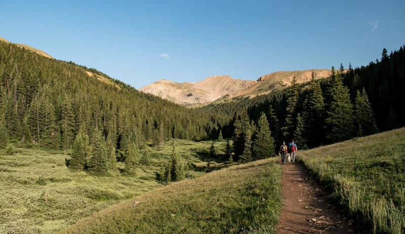
Pettingell Peak is a 13er unlike any other I've climbed. Why is that? The bottom portion of the hike is a heavily trafficked hike on a (mostly) smooth, wide trail. The top portion? There is no trail.
And when I mean heavily trafficked, I mean we passed 166 people and 19 dogs on the way down. (we were keeping track). After we left the trail we saw no one until we were halfway down the standard route.
After a brief climb, it opens up into this meadow.
Anyway, I included a couple route photos. We came up the East Ridge (but we joined it late), and came down the "standard Route". The East Ridge is possible to stay at class 2+ with a bunch of moving around, but we ended up doing a little class 3 climbing along the way. It's a good opportunity to test your route-finding skills.
I enjoyed this mountain quite a bit. It's not a 14er or in the highest 100, but its' East Ridge is fun climbing without a ton of exposure.
My GPS Tracks on Google Maps (made from a .GPX file upload):
Great pics of the route. I'm planning on giving this one a shot in the next couple weeks and have only found a few TR's that showcase this ridge. I hiked up to the lake earlier this year and got a good look at the area.
From guidebooks and TR's, it seems like most people gain the ridge further east by going up the wide, south-facing slope directly north of that last trail junction. I seem to remember some cool rock formations on that slope. I'll have to check out your path as well. Looks like there are a few different ways to gain that ridge.
i've only ever snowshoed HG in the wintertime twice, so seeing summer pics is kind of crazy! will have to go back in warm weather to tackle pettingell. thanks for the TR!!
Yes, most people gain the ridge earlier than we did. I'm not sure why we waited so long, but it worked out OK. We kinda made things up as we went along. Ours might be a bit faster or shorter, I'm not sure.
We bypassed some of the spiny points of the ridge, generally to the south. It depends if you want to make it easier or harder. Sometimes you stick to ridge proper and still have to downclimb into one of several small notches anyway. We climbed around the crux again to the left (south) and that was pretty much the end of the excitement.
Coming down the "Standard Route" was pretty simple.
Caution: The information contained in this report may not be accurate and should not be the only resource used in preparation for your climb. Failure to have the necessary experience, physical conditioning, supplies or equipment can result in injury or death. 14ers.com and the author(s) of this report provide no warranties, either express or implied, that the information provided is accurate or reliable. By using the information provided, you agree to indemnify and hold harmless 14ers.com and the report author(s) with respect to any claims and demands against them, including any attorney fees and expenses. Please read the 14ers.com Safety and Disclaimer pages for more information.
Please respect private property: 14ers.com supports the rights of private landowners to determine how and by whom their land will be used. In Colorado, it is your responsibility to determine if land is private and to obtain the appropriate permission before entering the property.


")
")


