| Report Type | Full |
| Peak(s) |
Wilson Peak - 14,021 feet Unnamed 13575 - 13,575 feet Fowler Peak - 13,507 feet "V 3" - 13,545 feet |
| Date Posted | 06/27/2018 |
| Date Climbed | 06/23/2018 |
| Author | Chicago Transplant |
| Wilson and the trying trio of tri's. |
|---|
|
Wilson Peak and The Trying Trio of Tricentennials Peaks climbed (in chronological order) Wilson Peak (14,017'): 48th Highest - 6/23/18 Introduction The remnants of Hurricane Bud that came through around Father's Day weekend had us staying local and below treeline that weekend. So it was no surprise that early last week both my girlfriend and I had already begun to long for a high elevation adventure the coming weekend. At least she had Monday off and was able to sneak Hope in! Where to go for the weekend? The San Juan National Forest was still closed, and Sunday's weather in the northern part of the state was looking like it could be stormy. A few days later news that the Stage 3 closure was being lifted and with a clear forecast in the San Juans, we decided to head that way. Of course the decision was one we considered on multiple levels, for one not wanting to burden the dry forest with additional traffic, nor wanting to burden our health with the potential for smoky skies. On the other hand summer recreation being a huge part of the local economies perhaps the return of visitors could help boost the slow start to the summer economy. Unfortunately we didn't realize the Telluride Bluegrass Festival was going on, so we never actually made it in to town to do our part on that front. I had first climbed Wilson Peak back in May of 2007. It was via a steep 50 degree snow route on the northwest face of a strong snow year. We might have finished in the standard route's final class 3 gully, but it was completely snowed in. Even the summit ridge was all snow for us, we never touched a rock. Before this past weekend I had never been up Wilson dry, and had never been to the Rock of Ages saddle. Even the trailhead was a new experience because I had climbed it before it was moved due to private property in Silver Pick Basin. I guess I mention it to show that even 11 years after finishing the 14ers, they can give you a new experience and sometimes a repeated peak can feel like a new peak. For Rachael it would be her 40th ranked 14er, many of her recent ones being in combination with nearby 13ers that were new for me and this would be no exception to that as our primary reason for choosing Wilson was actually to climb the tricentennial neighbors on the other side of the Rock of Ages saddle. While she would like to finish the 14ers someday, she has become more and more of a 13er climber since we started dating, and has over 130 new ones since we've been together. With having to be back in town by 6pm on Sunday, and a 4+ hour drive, we rounded out our weekend with another tricentennial, this one an orphan near Ophir known by its San Juan Mountaineers name of "V3" that has a statistically "easy" route. Three new high thirteeners and a fourteener sounds like a great way to make up for our previous weekend's wash out. 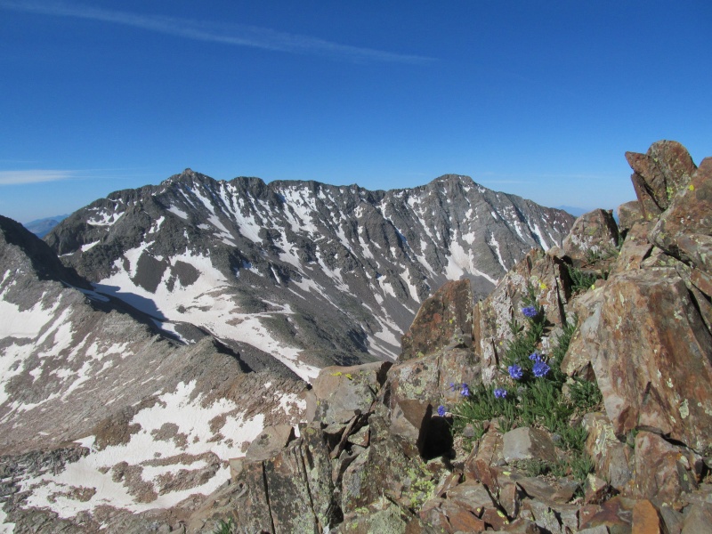 Day 1: Wilson, PT 13540 and "Big Bear Peak" from Rock of Ages Anytime you are headed out to climb peaks with loose rocks, exposure and class 3 and 4 terrain there is going to be a heightened sense of awareness as you prepare yourself for the mental and physical challenges. When your drive to the trailhead includes watching 4 county sheriff's vehicles, 2 of which have ATV trailers, coming down the road off a rescue mission at 11.30pm, it certainly adds to the anticipation. We briefly exchanged pleasantries as we pulled over to let them pass and found out that the patient was safely extracted with non-life threatening injuries. Just another reminder of the hazards of this hobby, and of how many rescue missions there are in these mountains that never make the headlines. We can't ever thank the local SAR organizations enough for how much they do, which is far more than we even think. We completed the drive to the trailhead with no issues, the mud puddles near the creek crossing were nearly dry and the water in the creek was low. An easy drive for the Subaru Outback (the next afternoon there was even a Toyota Yaris at the trailhead). We set up the bed in the trunk and settled in for a short night of sleep, only 5-1/2 hours until the alarm. These long days near the solstice are nice, however, and we hit the trail at 5.40am with no headlamps necessary and headed up the easy to follow and well signed trail. As the views along the trail opened up, we did see some significant smoke haze off towards Lone Cone. 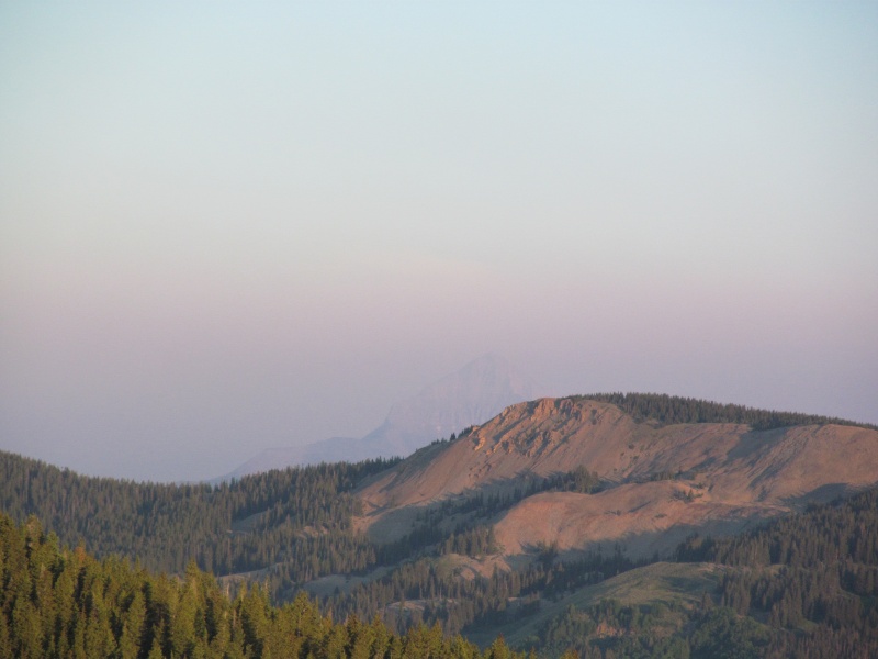 We crossed over the ridge and started a short trail descent towards Silver Pick Basin where old mining roads and private property criss-cross the route a little bit, initially these are well signed to keep you on route. Here the winds changed direction and some of the smoke came our way as the air smelled strong with burning wood. The trail continues to follow mining roads, where the SAR team shoveled out a snow bank to aid in getting their ATVs up for their mission, and eventually leaves the mining road at a signed junction. A short climb later the trail ends up on a grassy bench with the stone ruins of an old mining cabin and some more mining roads. 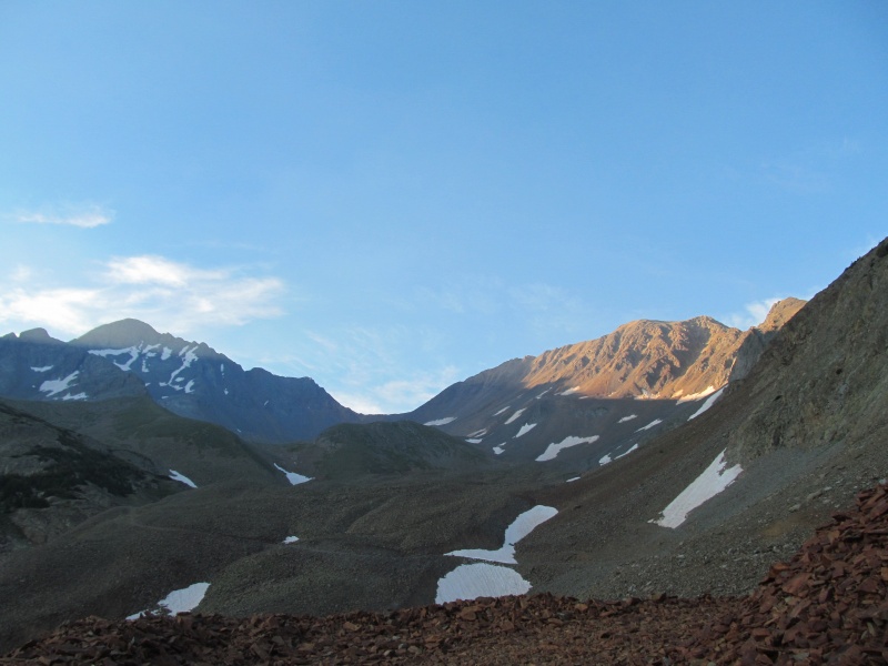 Here is where some snow obscured the trail on our way up and we ended up on an old mining trail that fizzled out. Seeing a bench that looked like a trail above we just continued straight up loose slopes and eventually regained the trail at a switchback near Silver Pick Mine at 12,600'. Another couple had similar confusion and followed us up this way. If there is still snow on that lower grassy bench, just stay left of the talus heap in front of you to find the trail, there were a few cairns around the corner beyond the snow. On the way down, we were on trail the whole way. Anyway, we continued our journey to the Rock of Ages saddle crossing one snowfield en route, then had a short break enjoying the hazy views before engaging the southwest ridge of Wilson Peak. 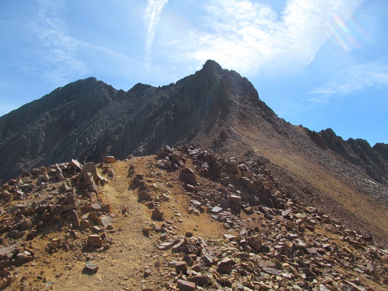 The climbers trail out of the Rock of Ages saddle is easy to follow and makes for efficient passage to bypass the lower difficulties of the ridge as it heads towards a small saddle on the Wilson-Gladstone ridge. From here you round the corner and are presented with the first significant challenges of the route, a series of exposed ledges with some class 3 scrambling. There is an option to drop about 100 feet and avoid them, at the time we climbed that would also involve a snow crossing. We stayed high and started across the ledges. One part in particular had some dirt on sloping rock with exposure that gave Rachael some hesitation, but we soon continued through the remaining broken terrain and picked up the climbers trail towards the false summit. Just before the false summit the trail switches to the other side of the ridge on some loose gravelly terrain. 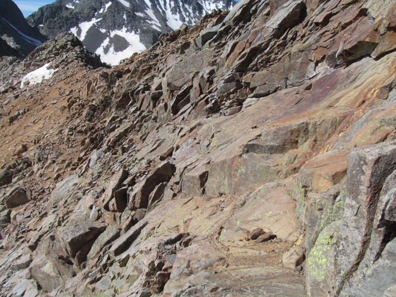 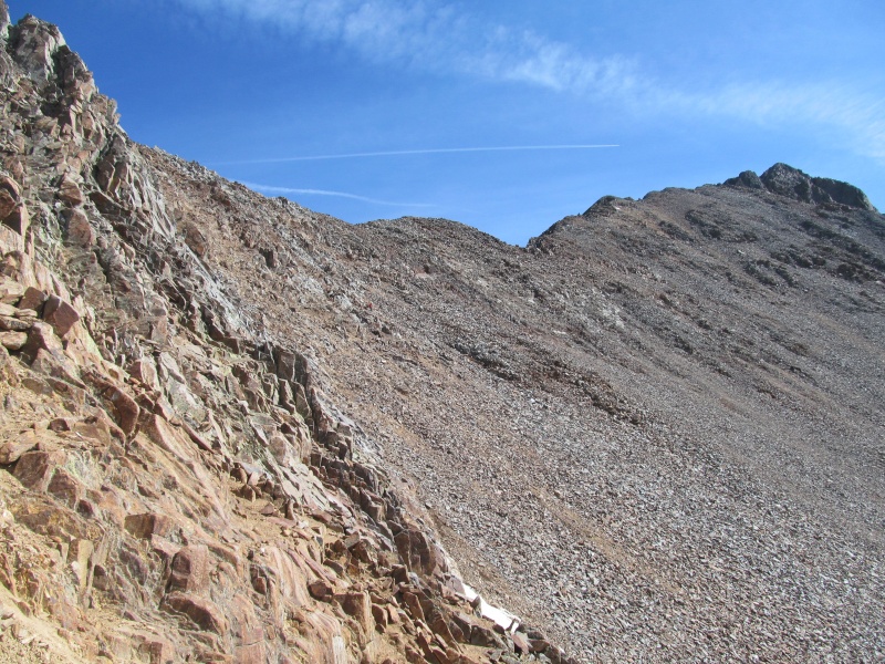 Dropping off the false summit required a few class 3 moves, but the exposure was less than that of the earlier ledges and the moves not difficult. A short traverse to the final ascent gully has a little more exposure but the rock quality was good here, one exposed step-around move and we were at the bottom of the final gully to the summit ridge. The scrambling here was surprisingly delightful, not quite as enjoyable as Wetterhorn, but the rock quality felt good and the moves were not exposed. We quickly found ourselves on the summit ridge where a short couple of scramble moves put us on easier terrain for the last short walk to the high point. This whole section went very smoothly for us, the earlier ledges being our crux as we found the route's finish to be enjoyable and the exposure quite manageable. These were taken on the descent and show some of the other climbers: 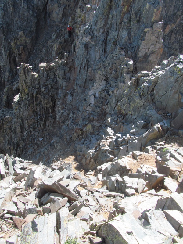 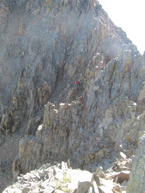 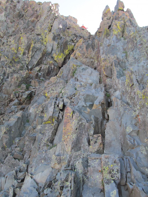 By now the smoke haze had shifted again and was now east of the Wilsons over towards Ophir Pass and Ice Lakes Basin. We hung out on the summit with a nice solo female hiker who was in town for the Bluegrass Festival and just couldn't pass up the opportunity to climb Wilson while in town. We thought that was a great decision! Her husband apparently didn't enjoy Lindsey that much and sat this one out. In our 13er quests we haven't shared many summits with strangers, so it was actually nice to meet someone this day, but we were also happy it was a summit party of only 3 as crowds are not our thing in the mountains. 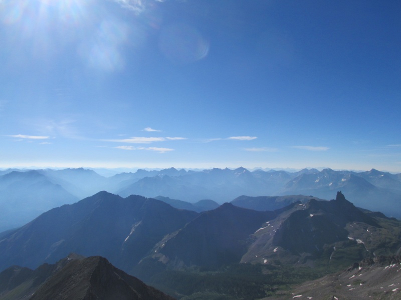 We retraced our steps back through the scrambling and over the false summit. On our way down we saw a few more groups on the upper trail. For our return, we decided to take on the class 3 ledges again and in this direction moved right through them without a second thought. Sometimes exposure is a matter of perspective, and in this direction it just felt less exposed for some reason. As we neared the Rock of Ages saddle we had a good view of the route up PT 13540 and decided to just take the ridge crest head on as much as possible. Our experience on the Wilson part of the climb was a good one, it was a new route for me and a new 14er for Rachael, who had to orphan this one after the Wilson-El Diente traverse several years ago from time constraints. A couple of the ones she has left are among the harder ones, and in some cases the ones with reputations for loose rock and/or exposure so it felt good to get another one of those done and without the traffic that makes those elements more challenging. Nothing quite like having people above you trundling rocks down an exposed route, we were grateful not to have had that experience here! 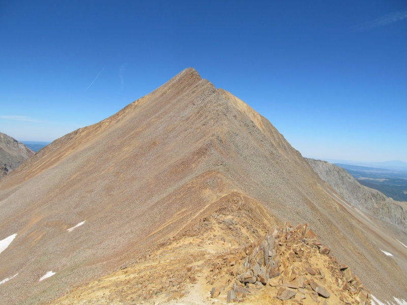 It was now time to leave the comforts of the beaten path and go back to the land of talus. The ridge crest above the saddle generally worked great being right on it, one place lower down we went a bit right. There were maybe 2 or 3 short class 3 sections on the ridge crest proper, the most exposure being right at the top of a false summit. 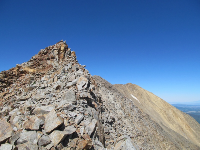 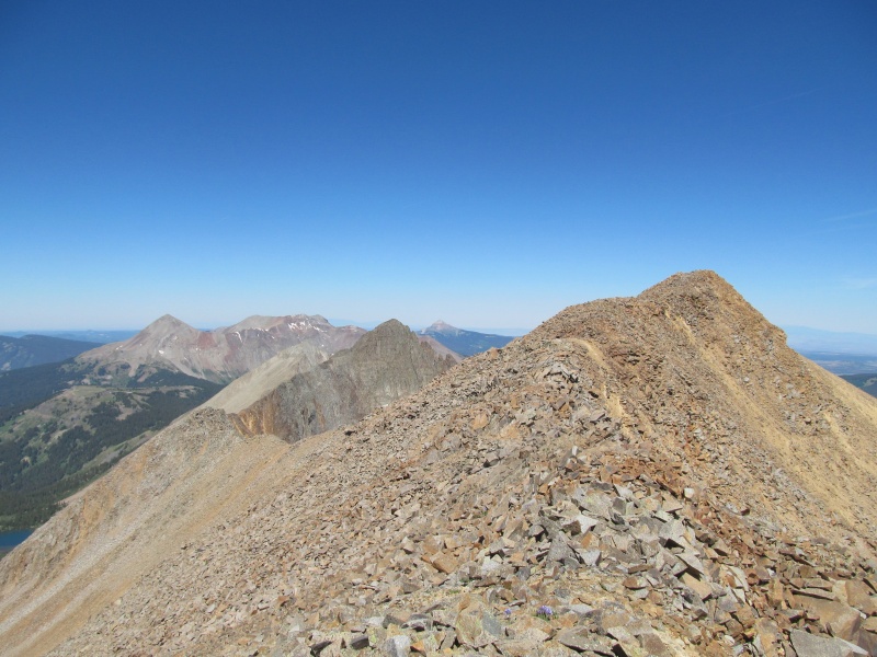 From the false summit the steepness relented and the ridge was generally quite stable as it gently reached the highest point which afforded excellent views of the surrounding 14ers and Navajo Lake. To the right steep scree slopes dropped some 2000 feet down to Silver Pick Basin, perhaps being worthy of a future ski descent? When this face fills in, there is a lot of potential for some fun skiing. This was an enjoyable summit, and really not that difficult of an add on if climbing Wilson and looking for a little something extra afterwards. The route gains maybe 550' tops from the Rock of Ages saddle on better than expected rock with great views. A nice way for people unfamiliar with San Juan 13er talus hopping to get a taste. We hung out briefly before it was time to head off for "Big Bear Peak". 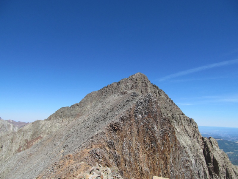 "Big Bear Peak" is the middle of three thirteeners on this ridge, the westernmost being "Woods Peak" which we climbed from Woods Lake last year. There is no easy way to climb "Big Bear" and any attempts to combine it with "Woods Peak" result in difficult loose scrambling and are generally not recommended. The side of the peak we were looking at from PT 13540 B is certainly the least difficult route, but it still involves class 4 climbing, loose terrain, and exposure. I had this one on my so-called "Dread List" of peaks with bad reputations for being junky rock with difficult scrambling. With limited information and the previous trip reports on this site having nothing particularly nice to say about it with things like "Everything was loose" and "The rock quality was far from par", tales of testing and re-testing of loose holds and nicknaming the peak "Meanie", I can't say it was one that I had found myself looking forward to. The good news is that the majority of the route over to it was actually class 2 ridge running on solid rock. The initial drop towards the saddle off PT 13540 B was easier terrain than the Rock of Ages side, and if it wasn't for the horrible loose rock to get to that saddle out of School Bus Basin, it would be the easier route for sure. School Bus Basin below is named for an old bus that used to live near the end of the mining road there, but unfortunately that climber's landmark was removed a few years ago. Check out Furthermore's TR on these if you want some good images of the old bus. Along the ridge crest were two other climbers who had come up out of School Bus Basin, I asked them about the rock quality and their response was "everything moved", solidifying our decision to reclimb PT 13540 B and go out the trail. 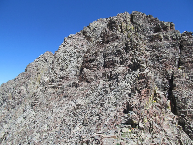 The low point of the traverse over was followed by a brief steep section of class 2 that was a bit loose, but then the ridge once again flattened out a bit to more solid rock as the base of the summit pyramid reared its mean looking head. From here, what is probably the easiest and safest route up this peak is to traverse across a rubble covered ledge to the base of an obvious gully with a large gash in it. The ledge was surprisingly stable and starting to show evidence of a developing climbers trail. There was some exposure to the left, however. At this point, the real climbing begins. The gully looks intimidating from afar, and not much different from up close. From the base, however, you can see that it is not as consistently vertical as it appeared earlier and the gully is comprised of multiple sections with ledges in between to break up the climbing and the exposure below. The first move is to scramble on to a small bench below a 10 foot headwall. I made my way up the left side by angling left then right on class 3 ledges to a wide flat shelf. Here on the right side of the shelf is a good place to tuck in and allow others to climb above you if in a group so as to avoid rockfall potential.  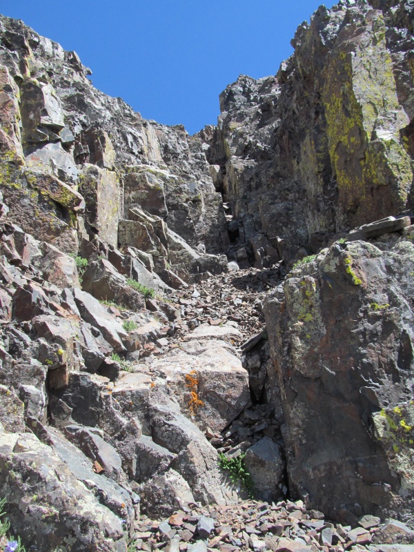 Above this the second step is steeper and class 4. Probably about 15 feet of climbing here, climbing the wall directly to the left of the large gash. The chockstones in the gash made it look impractical. Going up the holds were actually good here and felt attached to the mountain. A few blind feet for the descent, so I took mental notes of where I needed my feet for the way down. Above this was a loose class 2+/3 system of chossy ledges leading to the ridge crest. This was the sketchiest part of the gully despite the easier climbing due to the fact that you are now above a 15' cliff on choss covered ledges. 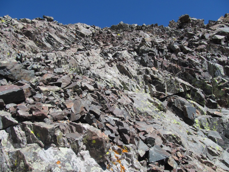 A quick scamper and you are on the ridge crest at a false summit, home free with just one quick class 3 notch with minimal exposure on good rock to the summit cairn. 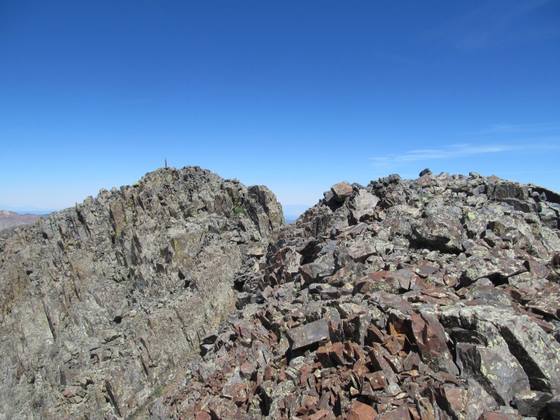 Either the views of the Wilson - El Diente traverse really are better from here, or its just that rewarding feeling of having reached a difficult and hard earned summit. Navajo Lake was looking pretty good too. With the other climbers making there way up and having to reclimb PT 13540 B, it was not a summit to spend a lot of time on, however. Here are some summit views: 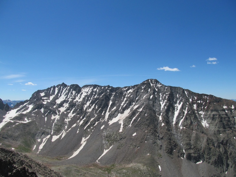 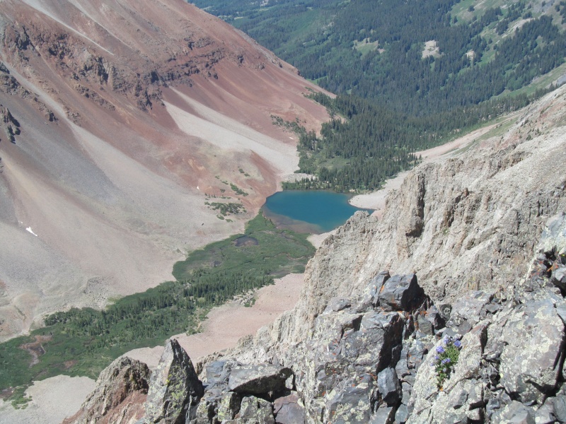 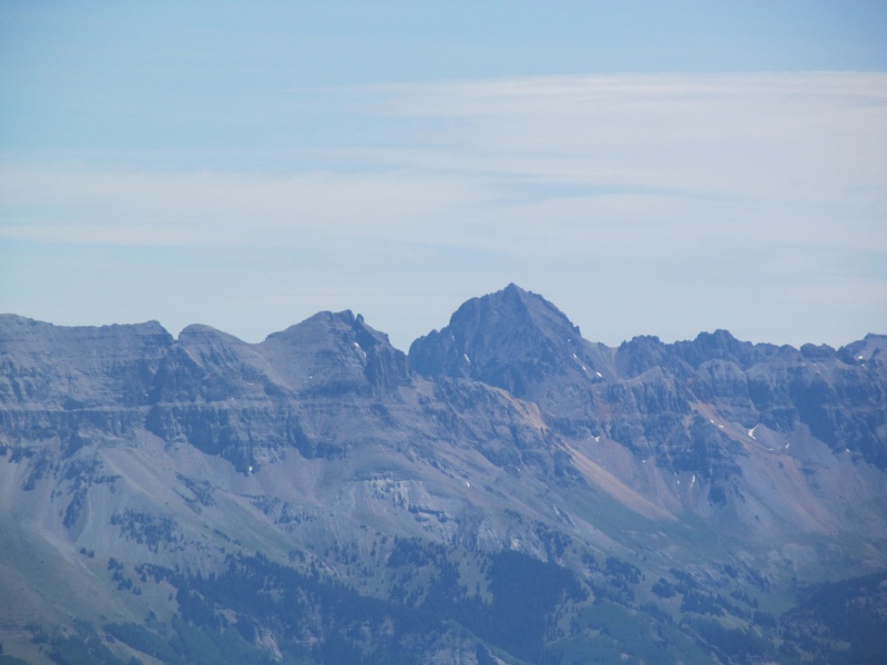 Retracing was a careful proposition as those chossy ledges needed to be carefully downclimbed to avoid trundling rocks over the cliffs below. At the top of the upper cliff, I could see that the climbers below were making there way over the lower headwall and hung out until we could communicate. 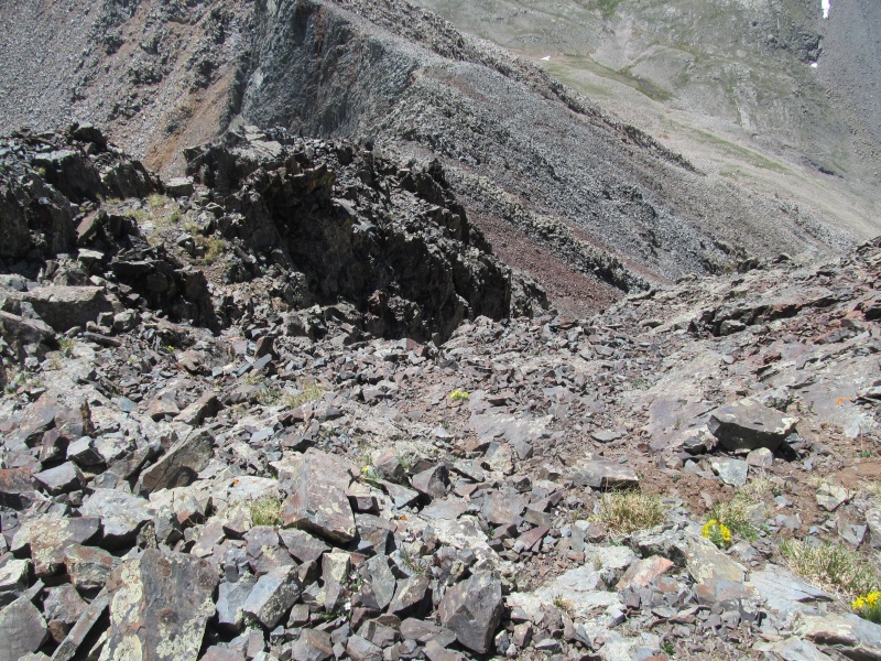 When they reached that initial ledge, they hid off to the side to allow for a safe descent. As I turned to face in and re-use the same holds I had pushed on to ascend, it became clear they were not nearly as attached to the mountain I thought they were. With pressure on the opposite direction, the were all wiggling. I was able to carefully apply a different pressure and find my previous foot holds, which thankfully were still solid. Then after climbing off the lower headwall gave the all clear shout to the group above so they could finish their climb and breathed a sigh of relief that this one was off the list. Ultimately it was more solid than I expected, but it was a careful and methodical climb of that gully especially near the top and certainly more challenging than anything Wilson Peak gave us. As an aside, apparently "Big Bear Peak" is currently in legislation to be officially named. Here is a link to an article regarding the proposal to name PT 13498 ("Big Bear") and PT 13123 ("Woods") to honor Charlie Fowler and Christine Boskoff who died climbing in Tibet in 2006: https://www.telluridenews.com/news/article_28b7bb90-460e-11e7-8829-b35138691256.html 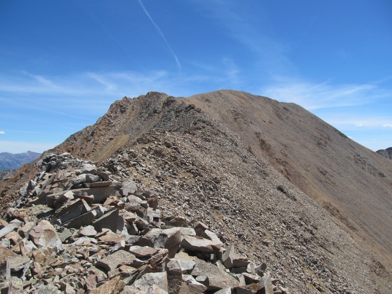 The reclimb of PT 13540 B was quick and uneventful and we carefully downclimbed its east ridge back to the Rock of Ages saddle for the 4+ mile trail hike back to the car, this time being able to follow it the whole way without any detours. 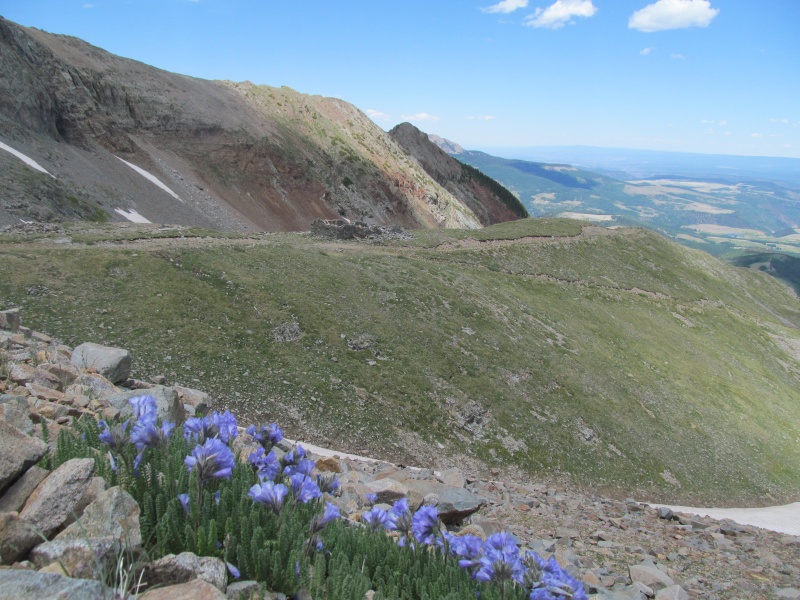  The drive back out was free of rescue teams this time, hopefully they will get a lengthy break from having to perform missions in this basin! We stopped at the gas station in Society Turn on our way to Ophir, but did not make it into Telluride. As mentioned earlier, the Bluegrass Festival was going on and we wanted to avoid the crowds. From the looks of the tent camping area in the park behind the gas station, it was a crowded affair! Day 2: "V3" from Swamp Canyon The road to the trailhead through Ophir was in great shape for the Outback. As you get farther up this road it gets steeper, rockier and more of a shelf and may not be suitable for my vehicle to drive over, but at least from the west getting to the trailhead was not difficult. There is one small stream crossing by a landslide area that could be an issue for lower clearance vehicles about 1/2 mile below the trailhead that some may need to park at instead. For us, the greatest difficulty was finding the trailhead as it is not signed, nor are any trails or side roads in this entire area outside of town for that matter. The trailhead is near a second sort of landslide looking area where Iron Spring is labeled on the map. This area is notable by an abundance or orange and red dirt and a large flat pullout on the north side of the road. To the south side of the road some ATV tracks led down to the river through the red and orange dirt, but you don't want to follow them that low. Just below the main road on the south, look for a normal colored brown dirt road taking off flat into the forest. Pass a few muddy puddles on the right and come to a gate with parking for maybe 3 vehicles. 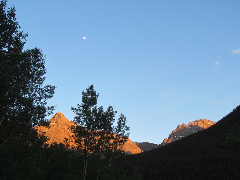 Follow this gated road to a larger clearing where the old road is overgrown and look sharply to your right towards a creek where you will find a second gate and a small wooden footbridge. This is the trail you want and it soon becomes another abandoned road after the creek. Where there is a road split a little farther up, stay right and continue to follow the road. After a short section with two dips, the second of which had a lot of cut-out deadfall, look for a cairned trail on the right a little ways up. This trail will take you to treeline with no bushwhacking, so its is the key to the lower route. Just stay on it as it crosses another unmarked trail, and continuing up its switchbacking path in the forest. 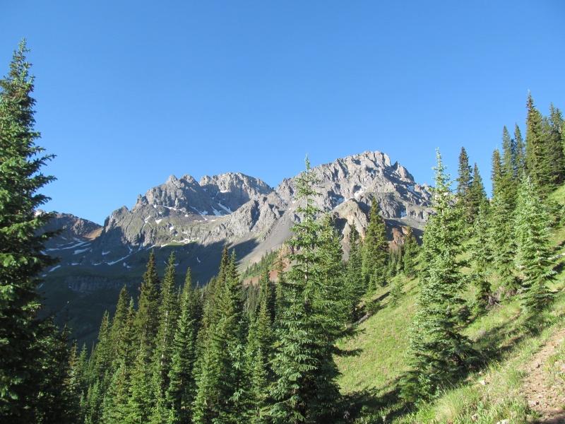 Eventually the trail will head up high above Swamp Canyon (the trail is never in the "swamp") as it crosses open terrain before turning uphill and reaching treeline around 11,300'. There is a trail that keeps going (maybe part of the Hard Rock 100?) but you will leave here at the base of a large and obvious meadow with some camping potential if interested. 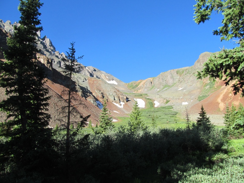 We took a little break here then began crossing the meadow towards the grassy headwall beyond. Steep grass with some game trails took us to a large grassy bench near PT 12348. This is essentially the end of the grass on this route and the beginning of a lot of tedius talus slogging. The route to this grassy bench is actually quite nice and has beautiful views. We found the hike to this point to be really fun and were having a great morning at this point. 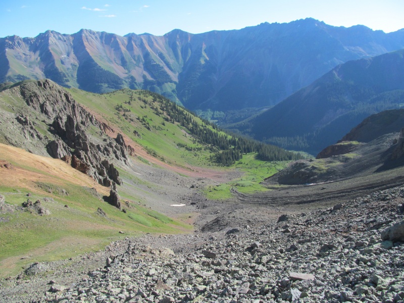 To climb the peak from this bench, first you have to head south over talus to a 12600' bench, there was a bit of a use trail in here if you can piece it together to help with the loose rock. Eventually that trail ended in a gravel slope which was holding some snow halfway up it that we skirted to the left. At the 12600' bench some easier terrain gets you up to the base of the west slopes of "V3" at about 12800' where the route ceases to be enjoyable. 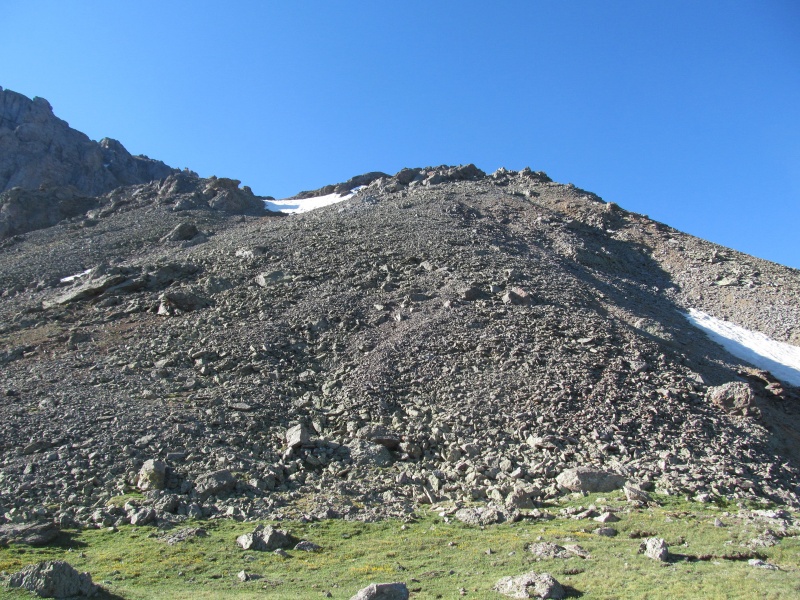 Previous reports note this slope as being a challenging slog, and it is. While we found more of it to be loose gravel than the dried mud of Furthermore's ascent, it was no less tedious. Instead of making a direct line towards the summit gully, we climbed below the wider gully to its left with plans of cutting over to the summit gully higher up.  This did not work out that well and we did not retrace our steps and would not recommend our route. For some reason from below this looked like a better option, but the higher we got the more it turned to hard pan dirt and we had to claw our way up the last bit to our exit point. Our exit point was then across more hard pan, at one point becoming so hard it might as well have been a cliff. The small rocks here were basically glued in place in the mud, which while on the plus side meant they wouldn't release, on the negative side meant there was not a centimeter of give when you took a step. This is probably the worst type of side hilling out there and while I just moved across as it as quickly as possible to get to the gravel and off our precarious perch, Rachael began to have visions of uncontrolled tumbles down the mountain and froze up for a bit. I hate putting her in these positions on these mountains, and I really did not expect us to find a spot like this on this climb. Once back on the loose gravel, we were able to make our way to the base of the summit gully. While the gravel was loose, it did afford a certain comfort that the hard pan did not, namely that you could actually leave a foot print in it and feel the comfort of some sort of purchase. 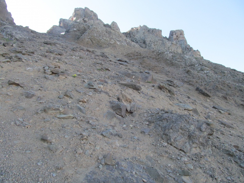 We ditched our poles and it was now time to engage the gully. I really didn't expect anything difficult out of this gully as neither of the two reports spend more than a sentence describing it and both make it seem trivial. I am one who has a pretty high threshold for agony in my mountain climbing, and I was surprised that this gully did not garner more attention in previous reports. Not to fault the authors at all, that is certainly not my intent. Mountains change, and everyone has their own memories of what was and was not their personal crux. Going back to Wilson for a second, the earlier 3rd class ledges were far more of a crux for our climb than either the false summit, subsequent ledge or the summit gully were and yet it seems one of those three are what usually get the attention of other climbers. Perhaps the gully on "V3" was in better condition for those who climbed it before us or perhaps they just simply found a better route, but our route was awful. As we scrambled up the only solid rock we could find on the left side of the lower gully, we neared a chockstone. The right side looked easier at this point, but the hard pan crossing was as bad as the previous one with the added bonus of being covered in loose dirt. I scampered across on whatever embedded rocks I could find and scrambled carefully up the right side, nearly pulling loose a rock the size of a small cooler in the process. Safely pushing it back into the mountain I made my way over the chockstone to check out the gully and saw that above me for the next 200 feet was dirty hard pan. 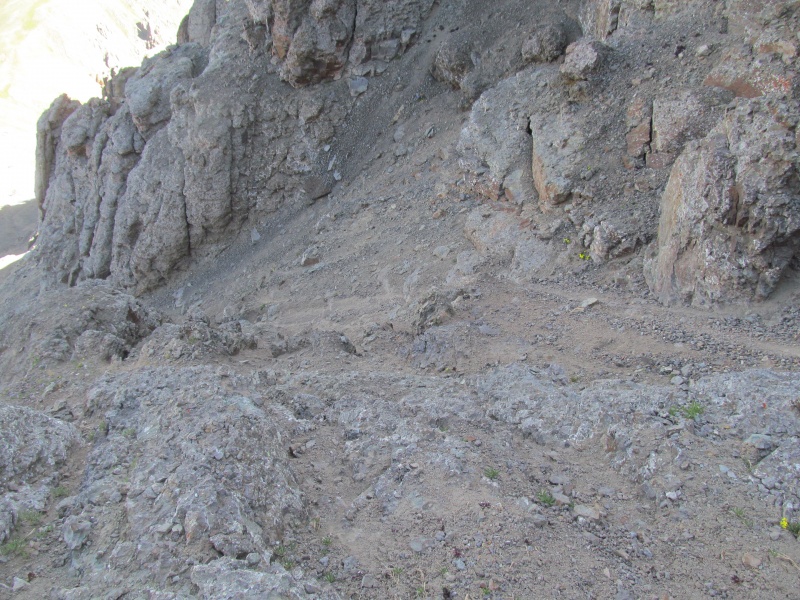 At this point I honestly wondered if I was even in the right gully given the difficulty of the terrain not matching the previous descriptions. Rachael made the decision to turn back, she is smarter than I am and has a motto that when it ceases to be fun its best to just turn back. My stupid list had me continuing on up the left side of the gully in loose gravel to find safer ground so she could descend without me pouring rocks on her. The gravel gave way to a point I had to cross back to the right once more where I could wait out her descent in a safe place. I could hear gravel pouring down beneath her and was concerned, but at the same time happy it was not hard pan dirt. Once she was safely out of my run out, I scrambled over ribs of rock on the right side of the gully that were mostly solid but had a few holds that wanted to pull out. Trying to find the most solid rock resulted in a couple of exposed class 4 moves. 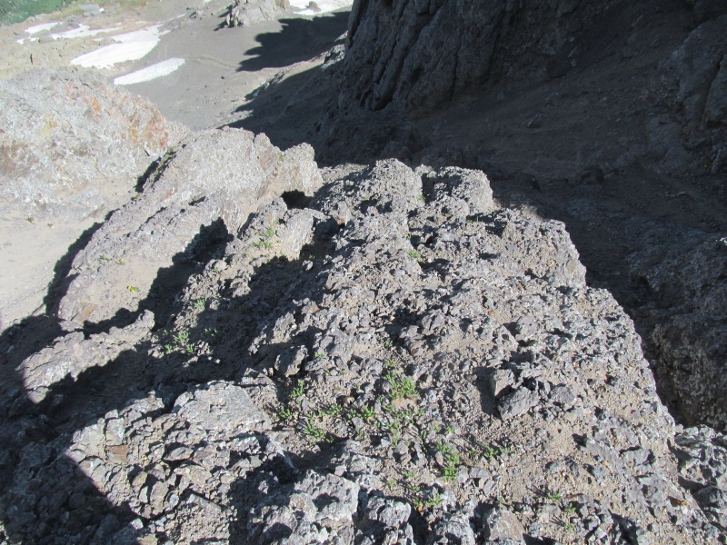 Above the ribs was close to another 100 feet of loose gravel to reach the summit area. I crawled up the loose gravel to some towers where I still wondered if this was the right gully as the highest point was difficult to discern and I falsely thought I needed to go around the right of the summit block. 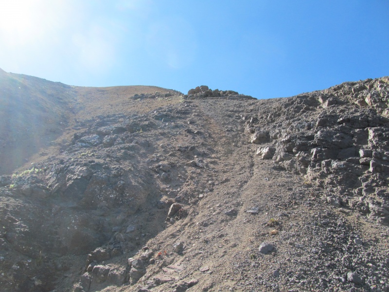 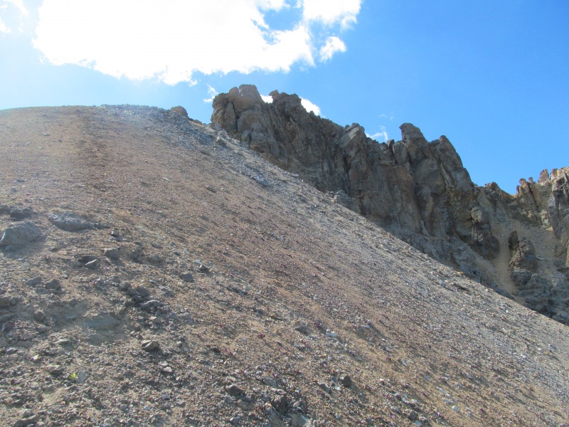 Inching towards what I hoped was the summit block, I was pleased to find class 2 ledges that went around the left to easier ground where I could finally confirm this was really the top and walk over a few rocky steps to the small high point and catch my breath while admiring the views. It was a short visit as I wanted to get back down to Rachael as quickly and safely as I could. 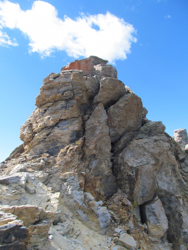 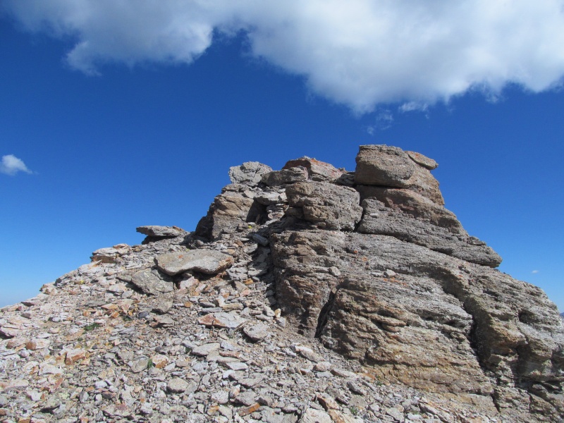 The descent back down the loose gravel to the rock ribs was not terrible, but did pour a lot of gravel down the gully. All of which funnels to the lower chockstone. Now the worst part of the gully awaited and it was a very tedious and careful downclimb. First through the rock ribs trying to find the solid rocks with my hands and feet, then the arduous crossing of the hard pan back to more gravel. Descending this gravel resulted in every step unleashing a bucket full over the chock stone and down the face below. In fact a light brown strip of dirt was growing below the chockstone with each step as more and more gravel joined the party. I gingerly recrossed the chockstone, avoided the cooler sized loose block and carefully back across the hard pan to our semi-solid ledges. More careful downclimbing as I looked for our pole stash and then it was just 400 feet of scree surfing to where Rachael was waiting. I felt like I was walking slowly, but I was moving quickly as each step I took resulted in 2-3 feet of gravel settling and sliding, and taking my steps with it. I guess in a way this would have been a better ascent? It was off the hard pan of our earlier gully, but fighting that kind of scree is certainly some of the most suffer-worthy terrain out there. 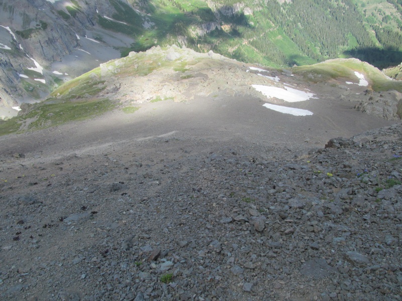 And like that it was done, the 700 feet of garbage that was the upper portion of "V3" was now behind me, never to see my feet again. If we did ever come back it would be as a couloir climb, but dry, this mountain is one and done for me. There is a good reason this one resides on the 50 least climbed 13ers on Lists of John! Soon we were back on our grassy bench and the remaining hike out was just as pleasant as the hike in. Beautiful views of the surrounding mountains, green grass, a healthy forest and eventually the road and our car. It was nice that the lower terrain was so enjoyable, it certainly made up for the upper mountain and lifted our spirits on our exit. 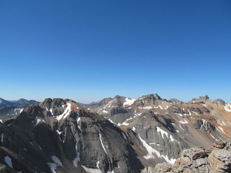 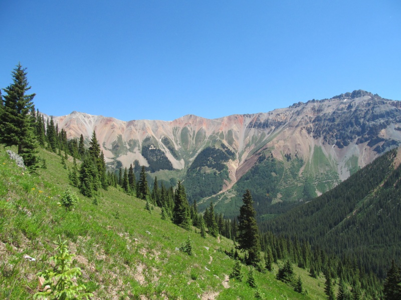 Conclusion Along the way hiking out from "V3", we talked about how this peak was one of the worst peaks I had climbed in a long time. About how every time I climb a peak like this I say the same thing, I will never climb that peak dry again. Yet I inevitably end up climbing one just as loose and just as tedious with a different name some other time. All part of pursuing a list, you win some and you lose some. Perhaps one of the things that made this peak so bad is that I really didn't think it would be. I had read the other reports and I guess sure, the slopes leading to the gully sounded like they would be a challenge, but I honestly thought once we reached the gully we were home free. In contrast, the expectations for Wilson and "Big Bear" were for a more challenging ascent. "V3" was not a peak I dreaded, "Big Bear" was. Wilson is among the most challenging of all the 14ers but we had a great time. I don't know if it is because of the expectations that the more difficult peaks were not as bad as we thought they would be? Perhaps because "V3" was not something we thought would be a challenge after having been so successful the day before that we maybe let our guard down and expected an easy walk? We were making great time on easy slopes until the final 700' climb, so maybe it just lulled us to a sort of complacency? I am sure someone else will climb this peak after reading this report and wonder why all the fuss, but maybe the same person would think I am crazy for thinking Wilson was relatively easy. Head game goes both ways, and maybe prepping yourself for a challenge helps you be that much more ready to take it on, and when you are not expecting one but get hit with one, that is when you get in your head instead. Thumbnails for uploaded photos (click to open slideshow): ")
")
")
")
")
")
")
")
")
")
")
")
")
")
")
")
")
")
")
")
")
")
")
")
")
")
")
")
")
")
")
")
")
")
")
")
")
")
")
")
")
")
|
| Comments or Questions | |||||||||||||||||||||
|---|---|---|---|---|---|---|---|---|---|---|---|---|---|---|---|---|---|---|---|---|---|
|
Caution: The information contained in this report may not be accurate and should not be the only resource used in preparation for your climb. Failure to have the necessary experience, physical conditioning, supplies or equipment can result in injury or death. 14ers.com and the author(s) of this report provide no warranties, either express or implied, that the information provided is accurate or reliable. By using the information provided, you agree to indemnify and hold harmless 14ers.com and the report author(s) with respect to any claims and demands against them, including any attorney fees and expenses. Please read the 14ers.com Safety and Disclaimer pages for more information.
Please respect private property: 14ers.com supports the rights of private landowners to determine how and by whom their land will be used. In Colorado, it is your responsibility to determine if land is private and to obtain the appropriate permission before entering the property.


