| Report Type | Full |
| Peak(s) |
Mount Shasta - 14179 |
| Date Posted | 06/26/2018 |
| Date Climbed | 06/01/2018 |
| Author | rob runkle |
| Mount Shasta via Avalanche Gulch, Bunny Flat TH |
|---|
|
Climbing Mount Shasta had been on my radar for years. The major challenge is that Shasta is up in the middle of Northern California, not very close to any other 14ers. I didn't want to schedule a trip just to get Shasta, so I waited for the right moment, where I could get Shasta as a side trip, connected to another vacation or climbing adventure. This year, we decided to take a 2 week family vacation to California, with our neighbors. Our plans for this vacation included spending a week in northern California, in Crescent City, CA. Crescent City is located 4 hours from Mount Shasta. I decided to go ahead and float the idea with my neighbor, Chris. For Chris, this would be the first time he would be tackling snow mountaineering. In fact, Chris would need to buy snow pants, ice axe, helmet and crampons for the trip. Chris was excited about the idea, and immediately purchased some new gear. Buying new gear is fun, even if the trip doesn't pan out. Once we arrived in Crescent City, we began to look at the weather report, and determined that Friday, June 1st would be the best shot for us to attempt Shasta. That would give us a few restful days with the family. Then, Chris and I would head to Shasta. The night of May 31, Chris and I headed out, with the intention of getting to the Bunny Flat Trail Head before dark. We were planning on car camping, then getting started very early. We ended up getting to the Trail Head around 8 pm. We backed the Minivan rental car into a nice flat parking spot, just inside the camping area, and tucked ourselves in for a few hours sleep.
We woke up just before 2 am, and got started up the trail around 2:15 am. With an early start, we hoped that we were giving ourselves the best chance at summit success. Honestly, the night before, I was starting to have doubts that we would be successful. For the most part, we were well prepared. We both had crampons, ice axe, plenty of water, food, and enough clothes for multiple layers. Neither of us had mountaineering boots, and I was concerned that might haunt us. Both of us would be wearing regular high top, water proof hiking boots. The advantage for us would be comfort, but the risk for us would be if the temps dropped much below freezing, we might have chilly toe issues. I was concerned that this might cause us to have to bail. I was also concerned that this might be a big jump for Chris; to jump from Summer 14ers (no snow) to an all out snow travel summit. Probably my greatest concern was the overall elevation gain. The standard route on Shasta (Bunny Flat TH, Avalanche Gully) is about 5-6 miles each way. And, the elevation gain is around 7,200 feet. Chris ran the numbers the night before and landed on something around 1,300 feet gain per mile. We compared that to other 14ers that we had done in the past, and this was several hundred feet steeper than most 14ers. Plus, 7,000+ feet of elevation in a single day is just brutal. Having said all that, I prepared myself that we might need to retreat without a summit tap. The The first 2 miles or so of the hike were nice dirt trail, and not too steep. We reached Horse Camp (2 miles) in just over an hour. Our pace was good, but mentally I was registering that we had not gained much in elevation. The remaining hike would get steeper. As we left Horse Camp, it stayed dry for maybe a half mile, then we transitioned to snow travel. We would end up being on snow for most of the rest of the day - until we got back to Horse Camp. We traveled the long - but not super steep lower Avalanche Gulch, up to the plateau where Lake Helen is located. It took us about 3 hours to get from Horse Camp to Lake Helen. At this point, we had traveled about 4 miles total. I figured the remaining route to the summit was around 1-2 more miles. And, we had just under 4,000 more feet of elevation left to gain. Man, this was going to get steep. From the Lake Helen camp, we could see people slowly moving up the upper Avalanche Gulch, and we were baffled by how it looked like they were not making very fast progress, up the gulch. It really, just did not look that steep. The view angle from the Lake is deceptive.
We messed around at the Lake camp for about 45 minutes, gobbling calories, drinking water and finally putting on our crampons, helmets and ice axes. From here to the summit, we would be using the big kids gear. After our break, we started up the upper Gulch. The wind coming down the upper gulch was definitely stronger than anything we had seen yet. It was probably 15-20 mph, and mostly sustained; definitely not enough to knock you around too much, but it was enough to blow through our regular hiking boots and chill the toes a little bit. It was really slow going. The pitch was about 35 degrees, which is probably double the steepness of what we had been doing up to this point. It took me a while to get into a rhythm going up the steep grade. I tried side-to-side switchbacking, duck walk, cross over feet walking. Ultimately, I settled on a mix, depending on the exact grade I was on, and if there were any good foot steps already in the snow. Chris was cruising along a bit more slowly than I was, but I never let him out of my sight. Chris had mentioned at the Lake Camp that his toes were worrying him. Mine were cold, but from the sounds of it, Chris's were colder than mine. The constant wind did not help much. I knew that he could make the ultimate call to retreat if we needed to. I wanted to keep him in sight, so that he could communicate to me if it came to that. Every once in a while I would wait for Chris to catch up, just to get a feel for how he was doing. He was struggling, but still determined. At this point, we had not seen the sun light. The sun was teasing us, but was still blocked by the ridge. About half way up the upper gulch, the sun finally hit our bodies. At that same moment, the wind seem to taper by about 5 mph. Our toes and bodies warmed pretty quickly. Within 30 minutes of some nice sun, frozen body parts were no longer a concern of ours. We were still going very slowly up the gulch. As we approached the top of the gulch, I was more and more determined to end this evil steep climb. This steep stuff was just brutal on the calves. We ultimately reached the top of the gulch in around 3 hours, with Chris about 15 minutes behind me. I was able to watch Chris as he finished the climb and he looked wasted. At this point, I was pretty sure that we were going to turn around and go back down. When Chris said to me, "My heart feels like it is going to burst through my chest," I was 90% certain that we were going to head back down. I would ultimately let Chris make the call. I was prepared for either decision.
We rested for about 30 minutes at the top of the gulch, along the side of the "Red Banks." Maybe the most brutal thing about the upper gulch climb is that it is non-stop UP for the whole time. It is steep enough that you really cannot even rest comfortably. If you were to sit down and rest, you would most certainly send a piece of gear flying down the gulch. So, basically, since there was no easy way to rest, and no good way to park your butt, you just keep moving. Brutal and sustained. We talked to some people during our rest. There was good news and bad news. The good news was that the hardest part was definitely over. The upper gulch was definitely the crux of the route. The bad news was that they summit was still 2.5 hours away. I had in my mind a 10-11 hour turn around. I didn't know til later, but Chris had in his mind a 12 hour turn around. At this point, we were about 8.5 hours into the hike. +2.5 hours would put us at my high end turn around. I left it up to Chris. I told him that it worried me what he said about his heart bursting out of his chest. He said that he was alright, just slow.
After a 30 minute break, we started towards the final summit pitch. The route goes right around the top of the "Red Banks," then makes a right turn up hill, towards the based of Misery Hill. We were slow going, but we kept going up. The steepness and difficulty of the route was definitely nothing like the crux. It was steep, but not too crazy. The wind had died down to a comfortable level. As I reached the base of Misery Hill, I waited for Chris to catch up. I quizzed him on how he was feeling, and asked if his heart was bursting out of his chest on the last section. He said that he was fine, just slow. At this point, I knew that we had this thing in the bag, and I told Chris so. This was the first time during all the planning and hiking that I was over 90% confident that we would tap the top. Misery hill is similar to the top of many 14ers. It is basically a false summit with a very mild grade to get to the top and over the hill. If it weren't for the fact that we were rolling on 9+ hours of hiking, very little sleep, and 6,000+ feet of elevation gain, "Misery" would not be a proper name. But, given the nature of the preceding portions, Misery was certainly miserable. Similar to the top of the gulch, I was just determined to get to the top of Misery, just so that I could get it over with. I ground my way to the top, and was probably 100-200 yards ahead of Chris. At this point, I could clearly see the final pitch to the summit. I was getting excited. Standing in one place, I was a bit cold, so, I might have annoyed Chris, as I tried to "inspire him" to move his butt up the hill. Once Chris gained the summit of Misery Hill, we headed towards Shasta. 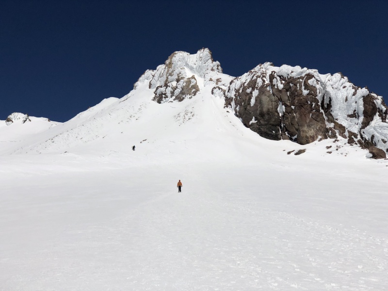 We ultimately made the summit in just under 2 hours from the top of the Gulch. Total time from trail head to summit for us was around 10 hours 45 minutes. I had met my high end cut off time. And, Chris had beat his ultimate cut off by an hour. We spent maybe 30 minutes on the summit, soaking in the sun and celebrating our summit. I was still a bit worried about our time. With almost an 11 hour ascent, I figured we would take at least 6-7 hours to descend. That is usually the case for me anyhow. That would put us close to 18 hours round trip, potentially hitting the trail head well after dinner time, and certainly put us into soft messy afternoon snow during our hike out. I had not calculated in my head a 2,500 feet glissade.
After our summit break, we started to descend. Going downhill was certainly a nice break. We made great progress downhill, and made it to the top of the gulch very quickly (est 1.0-1.5 hours). I had not considered a glissade descent, mostly because I was intimidated by the steepness and total elevation drop of the upper gulch. But, there was another guy that we met at the top of the gulch, and we was getting ready for a glissade, and had no doubts about the conditions or the steepness. As I saw him take off down the gulch, I jumped into his glissade trough and started my own butt slide. As we started to glissade, Chris and I discussed at length glissade methods and how to pull out in emergency: 1) use your axe like a rudder. 2) If your axe isn't slowing you enough, use your heels to dig in and scoop up loose snow (without crampons, of course). 3) If you feel like you are going too fast, or out of control, flip over and self arrest with the ice axe. We practiced all of these methods multiple times before committing to the 2,500 foot plunge. As we glissaded down, both of us got a lot more comfortable, and by the time we hit the bottom we were pretty much going full speed, with hands up in the air. What had taken us well over 3 hours to ascend, took us barely 15 minutes to descend. Totally worth it! At the bottom of our long glissade, we were pretty much back at Lake Helen camp. As we stood up to start walking, it became very clear that the soft afternoon snow would be our tormentor for the next hour or so. The snow was soft, and each downhill step was of random depth. So, you either landed fine and continued downhill, or you post-holed up to your knee and almost fell forward trying not to break your leg. It was miserable, especially below the Lake Camp. I was slipping and sliding all over the place, just trying not to wipe out, or bend a leg backwards. Although I was going downhill faster, Chris seemed to be having a better time at it than I was. As we finally reached dry ground, Chris admitted to me that he was having his own suckfest during the descent. We cruised onto the dry land and continued past Horse Camp. As we made the last miles to the trailhead, we were talking about how it seemed so long ago that we had ascended the lower trail. We also talked about how this last 2 miles seemed to take for ever. We finally got back to the trail head at around 5:15 pm. Total round trip was 15 hours, which means that our descent was between 3.5 to 4 hours. Yeah, Glissade! I'm still amazed that we made the summit. This is probably one of my longest hiking days ever, and in the top 10 for overall elevation gain in a single day. As I look back, we might have bit off more than we could chew - on a family vacation at least. But, I sure glad that somehow managed to swallow it all down. I'm pretty freaking impressed with Chris also, and I told him that many times over the following days.
Thumbnails for uploaded photos (click to open slideshow): ")
")
")
")
")
")
")
")
")
")
")
")
")
")
")
")
")
|
| Comments or Questions | |||||||||||||||
|---|---|---|---|---|---|---|---|---|---|---|---|---|---|---|---|
|
Caution: The information contained in this report may not be accurate and should not be the only resource used in preparation for your climb. Failure to have the necessary experience, physical conditioning, supplies or equipment can result in injury or death. 14ers.com and the author(s) of this report provide no warranties, either express or implied, that the information provided is accurate or reliable. By using the information provided, you agree to indemnify and hold harmless 14ers.com and the report author(s) with respect to any claims and demands against them, including any attorney fees and expenses. Please read the 14ers.com Safety and Disclaimer pages for more information.
Please respect private property: 14ers.com supports the rights of private landowners to determine how and by whom their land will be used. In Colorado, it is your responsibility to determine if land is private and to obtain the appropriate permission before entering the property.