Download Agreement, Release, and Acknowledgement of Risk:
You (the person requesting this file download) fully understand mountain climbing ("Activity") involves risks and dangers of serious bodily injury, including permanent disability, paralysis, and death ("Risks") and you fully accept and assume all such risks and all responsibility for losses, costs, and damages you incur as a result of your participation in this Activity.
You acknowledge that information in the file you have chosen to download may not be accurate and may contain errors. You agree to assume all risks when using this information and agree to release and discharge 14ers.com, 14ers Inc. and the author(s) of such information (collectively, the "Released Parties").
You hereby discharge the Released Parties from all damages, actions, claims and liabilities of any nature, specifically including, but not limited to, damages, actions, claims and liabilities arising from or related to the negligence of the Released Parties. You further agree to indemnify, hold harmless and defend 14ers.com, 14ers Inc. and each of the other Released Parties from and against any loss, damage, liability and expense, including costs and attorney fees, incurred by 14ers.com, 14ers Inc. or any of the other Released Parties as a result of you using information provided on the 14ers.com or 14ers Inc. websites.
You have read this agreement, fully understand its terms and intend it to be a complete and unconditional release of all liability to the greatest extent allowed by law and agree that if any portion of this agreement is held to be invalid the balance, notwithstanding, shall continue in full force and effect.
By clicking "OK" you agree to these terms. If you DO NOT agree, click "Cancel"...
I suppose like many on this website, after a few successes on 14ers, I began to aspire to do the harder and more technical routes that they I've seen on the internet or read about in guidebooks. Sometimes these routes have seemed just out of reach either from a technical or fitness standpoint. Other times they seem significantly out of reach and have served as powerful motivators. Since I started ice climbing in 2013 I have always had my eyes on West Gully (WI3-4, II+, 600 ft). In April of 2015 I hiked all the way to Black Lake and saw it firsthand, and motivated me even more to keep working towards one day sending the line.
Google Earth Map of Black Lake Area
Top of the route coordinates (approx)
40.264825, -105.647014
Part of the challenge of sending this line is mostly just having everything align all at once so you can do it. Many strong and competent parties have been turned away due to extreme wind, avalanche danger, or getting slowed down due to having to break tail after Mills Lake.
In fact several people I've talked to had been shut down multiple times just before ever even getting to the ice just due to conditions.
We were very fortunate to have everything align for our attempt.
I woke up at 230 am and was on the road by 300 am, I picked up Brian (MyFeetHurt) just after 345am and we headed for Rocky Mountain National Park (RMNP). We parked at the Glacier Gorge trailhead around 530 am and were hiking in darkness with headlamps shortly after that.
About half of the technical winter climbing in RMNP is reached by starting at the Glacier Gorge trailhead. The main trail follows the Glacier Creek drainage which originates up at Frozen Lake (6.1 miles away) and passes by Black Lake, Jewel Lake, and Mills Lake before being joined by Icy Brook from the Loch Vale area. To reach Black Lake you follow the summer trail and take the Mills Lake cutoff and follow the drainage.
As you hike around to the east of Mills Lake you can see Thatchtop Mountain (12,667 ft) to the West. We reached Mills Lake around 630 am just as the night was giving way to dawn. High up on Thatchtop we could see a few parties already up on All Mixed Up ((AMU for short) WI3-4, III, 550 ft) I had tried AMU in early November but got shut down due to a late start, crossing the lake too soon, and generally just poor route finding.
AMU
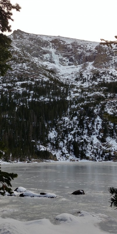
Even if you are not a technical climber, it's worth hiking up to Black Lake in the winter. Generally speaking there is a fair amount of solitude, and after fresh snow it would be a lot of fun to just snowshoe around. There is a ton of ice visible on both sides of the Glacier Creek drainage â‘ even more so with the start of this winter being such a low snow start.
Once we past Jewel Lake, we spent a minimal amount of time breaking through thigh deep snow getting to Black Lake, and it seemed like just maybe we were going to get lucky with the conditions. Long before you get to Black Lake proper you can start to see the upper pitch of West Gully. The upper pitches were looking pretty fat, and we were getting excited.
West Gully as we climbed it. Red = ascent, blue = belays
West Gully Route Topo
Once at Black Lake we debated how to get to the base of the route, which involves crossing a potentially loaded 40 to 45 degree snow slope to get to the ice. We went from a little cluster of boulders on the left and wallowed through maybe 100 ft of sometimes waist deep powder to get near the face of the cliff and then slowly up to the ice. I tend to think that those of you who seek out this type of terrain (moderate to steep snow climbs) in the winter are masochists.
Snow field approach
Once at the ice you get a number of options and depending on how much of hard man you feel like being (or not being) you can more or less chose your line. I opted for this little ice filley chimney far climbers right which turned out to be a lot of fun, and built the first belay far right just below a large shelf. (WI3, 65 m)
Brian can be seen in the blue at the bottom of the route as another party approached.
Top of Pitch One
There was a great stance in the chimney and Brian took a photo of me at the belay while he climbed up.
View of first belay from ice filled chimney
From the top of pitch 1, the route meandered around some before reaching a bottleneck where a second party had climbed up to. I chatted briefly with the other leader, and told him I was going to climb up to the right and set an anchor at the top of the snow. He said he would go up left. He ended up doing a half pitch almost and setting up the top of his second pitch about 20m higher than me. I did manage to get a pretty great shot of him on lead though. (WI 2-3, 35 degrees, 60m)
Top of Pitch Two
Ah pitch 3 - anywhere from 70 to 90m in length depending on where you start, and it is a total calf burner. The climbing is easy but insanely exhausting after the hike, approach, and all the other ice. Someone on Mountain Project called this section the âenduro slabs' which is totally apt.
Starting up Pitch Three
Shot from Brian of me at the top of the pitch 3.
Belay station for pitch three
Looking down from the top of the whole route at Black Lake.
Top of Pitch Three
I stopped maybe 20 feet from the very top as it crested over â‘ mainly to ensure there would be enough ice to build a v thread from and rappel down. (WI2-2+, 65m)
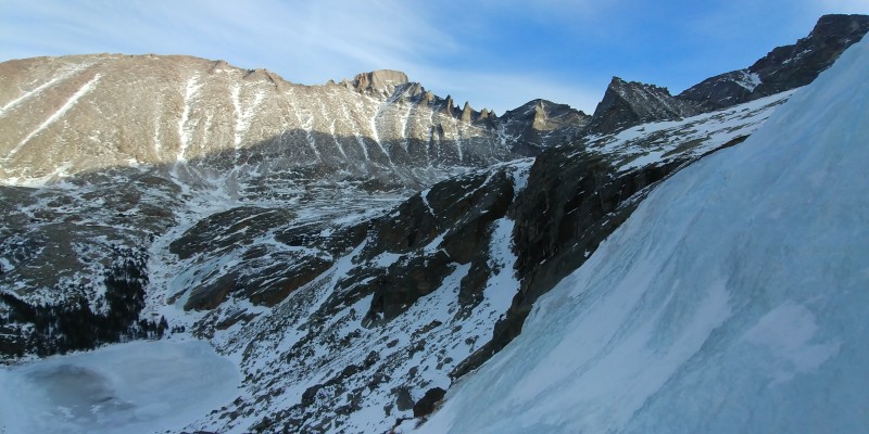
The view of longs and the entire cirque was incredible and one of the most satisfying experiences I have ever had in the mountains. If you look just above the lake you can see Black Lake Slabs (WI 2-3, II, 500 ft) which is fun outing and generally much safer from an avalanche standpoint.
View of Longs from the Top of the Route
We proceeded to build 3 zero threads (v threads with just the rope) and got down just after 4pm. Brian snapped this awesome pic on rappel.
On Rappel
We hiked back and made it back to the car around 6:45pm, car to car around 13 hours.
Things we did well:
Early start time
Didn't get lost or spend excessive amount of time breaking trail
Route within our ability
Didn't over or under pack on gear / food/ etc
Low avalanche risk day
Things to improve on:
Better located belay stations
Faster transition at belay stations
More alpine draws to allow for a wandering route choice
Faster at drilling v threads to get down quicker
Comments and critiques welcome.
Thumbnails for uploaded photos (click to open slideshow):
I've seen the pictures and recommendations approaching West Gully from the left. It seems someone triggers an avalanche there every year. Approaching from the right (under Black Curtain) puts one on the lee side of a snow ridge bordering the snow slab and is generally much safer.
to be sure about the approach. I will keep that in mind next time. I would not want to attempt the route with much more snow on it than we did. I think choosing a low risk day is key with this route.
Great climb, excellent partner. I learnt too things, something about oxford shoes never going out of style and I forgot the other.
Caution: The information contained in this report may not be accurate and should not be the only resource used in preparation for your climb. Failure to have the necessary experience, physical conditioning, supplies or equipment can result in injury or death. 14ers.com and the author(s) of this report provide no warranties, either express or implied, that the information provided is accurate or reliable. By using the information provided, you agree to indemnify and hold harmless 14ers.com and the report author(s) with respect to any claims and demands against them, including any attorney fees and expenses. Please read the 14ers.com Safety and Disclaimer pages for more information.
Please respect private property: 14ers.com supports the rights of private landowners to determine how and by whom their land will be used. In Colorado, it is your responsibility to determine if land is private and to obtain the appropriate permission before entering the property.
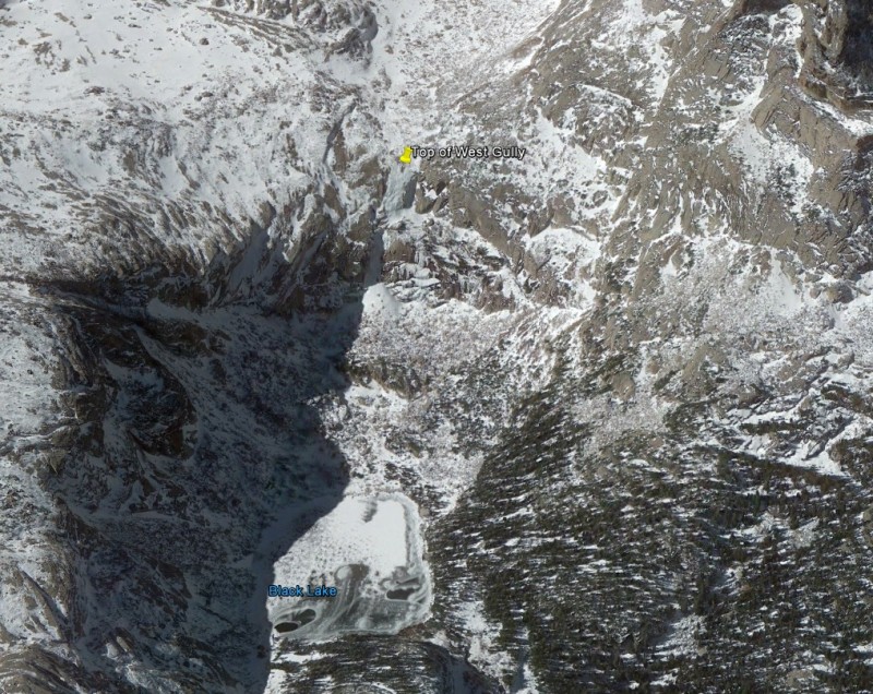


 Google Earth Map of Black Lake Area")
 Top of Pitch One")
 Top of Pitch Two")
 Starting up Pitch Three")
 Top of Pitch Three")
 View of Longs from the Top of the Route")
 Snow field approach")
 West Gully Route Topo")
 View of first belay from ice filled chimney")
 Belay station for pitch three")
 On Rappel")
 AMU")