| Report Type | Full |
| Peak(s) |
Wheeler Peak - 13161 |
| Date Posted | 01/02/2018 |
| Date Climbed | 11/26/2017 |
| Author | rob runkle |
| Wheeler Peak - State High point of New Mexico, Williams Lake TH |
|---|
|
During a business trip, I was able to sneak off for a day and hike Wheeler Peak, the high point of New Mexico. Wheeler Peak is located near Taos, New Mexico, about 3 hours North of Albuquerque, NM. I left my hotel in ABQ around 5 am in the morning, with the intention of getting started around 8 am. The drive to the trail head was uneventful. Typically by the end of November, the Taos Ski area would have snow. But, this year had been pretty dry. Fortunately, for me, that meant that I would not need to carry snowshoes, crampons, or any ice and snow gear. I dressed for 30-40 degree weather and carried extra gear and supplies that would protect at sub zero temperatures, if necessary. But, my hike would mostly be a dry and moderately chilly hike. I parked the car, at a well marked trail head parking lot, towards the end of Kachina Road; before the Phoenix Grill (Bavarian) restaurant. My planned route was the Williams Lake trail. I got started just after 8 am. Since I wasn't 100% sure of the trail conditions, I was prepared for a 7-8 hour hike. But, I was hoping for more like 5 hours or less. From the parking lot, I started hiking South, past the restaurant, back along the road for a short period, then eventually onto a wide trail. The lower trail was packed pretty good with snow. A few spots were slick, but the snow wasn't very deep. At times, this made for slow travel, as I would have to negotiate slick spots onto dry terrain. I had carried my microspikes, but did not feel the need to put them on. The terrain was mixed dry dirt and rock, and snow, and I didn't want to expose my spikes to the rock. Basically, I was too lazy to sit down and put them on my feet. I made good progress up to the Williams Lake turn off. There is a clear sign at the turn off. The trail to the lake continues straight. The trail to Wheeler Peak takes a sharp left. By this point, the trail was solid single track. If it were dry, the trail would be very runnable. But, the slick spots kept me from going very fast. I took a left towards the peak. I made it to the turn off in around 45 minutes. I was making pretty good pace, but up to this point, the grade had not been very steep. The turn off is about 2 miles into the hike, so it is just under halfway from a mileage perspective. And, the elevation gain at the lake turn off is about 1000 feet of the total 3000 feet from trail head to summit. 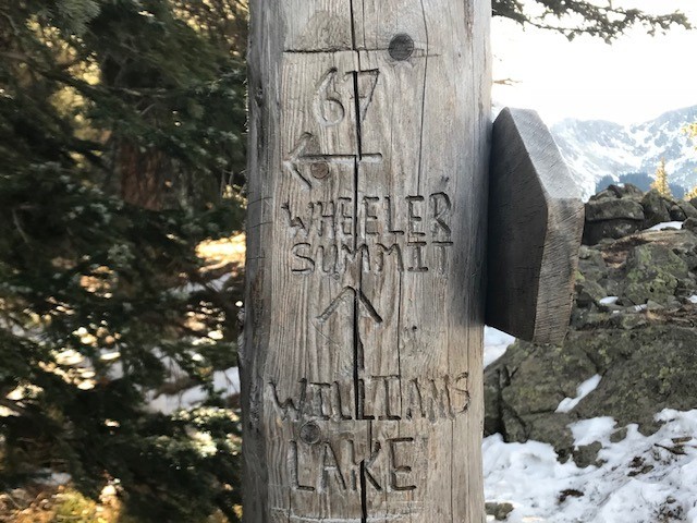  After the turnoff, the trail takes a bunch of switchbacks, and eventually opens up just above treeline. Once you get above tree line, you get a pretty good view of slopes of Wheeler Peak, and the saddle between Wheeler and Mount Walter (second highest point in NM). The switchbacks continue up to the saddle. At the saddle, the trail turns right (South), towards Wheeler. I got to the summit in just over 2 hours 10 minutes. I spent about 20 minutes on the summit, ate, drank and took some pictures. I should mention that the terrain pretty much stayed the same the whole way up. Most of the trail was dry, but there were sections of snow that were more shaded from the sun. The snow sections were packed hard, and were pretty slick. The slick sections were not dangerous in any way, but they slowed me down. 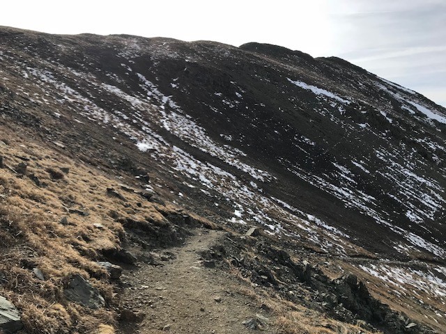 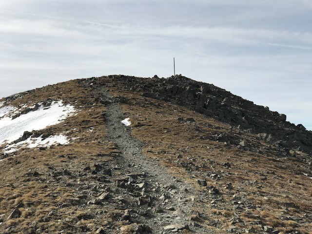 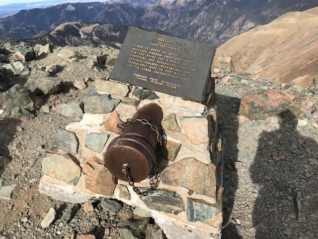 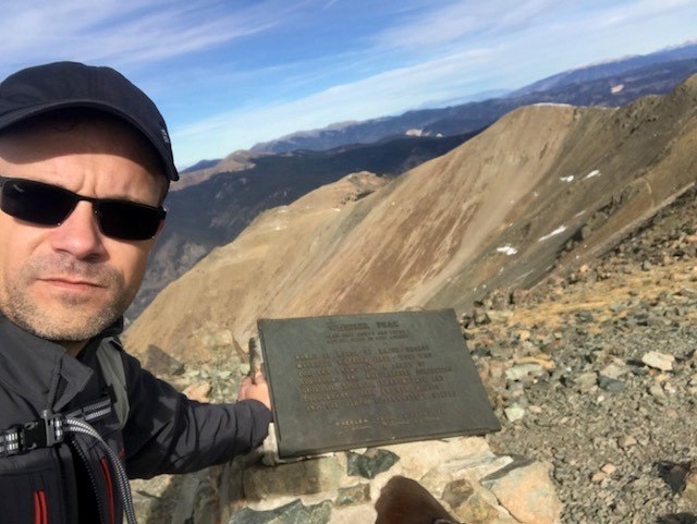 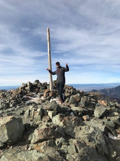 After my summit break, I started back down towards the saddle. I decided that I might as well grab the second highest point in NM - Mount Walter - while I was up there. It took me just under 10 minutes to get from the summit of Wheeler to the summit of Walter. I spent almost no time on Walter, then started heading back towards the trail head. The descent was pretty easy. On the dry sections, I was able to run, but on the icy sections I had to go much slower. Several times, I slipped and landed on my butt. It took me about 1 hour 20 minutes to get back to the trail head. Total round trip, was right around 4 hours (8.66 miles, 3,028 ft elevation gain).  Thumbnails for uploaded photos (click to open slideshow):
|
| Comments or Questions |
|---|
|
|
Caution: The information contained in this report may not be accurate and should not be the only resource used in preparation for your climb. Failure to have the necessary experience, physical conditioning, supplies or equipment can result in injury or death. 14ers.com and the author(s) of this report provide no warranties, either express or implied, that the information provided is accurate or reliable. By using the information provided, you agree to indemnify and hold harmless 14ers.com and the report author(s) with respect to any claims and demands against them, including any attorney fees and expenses. Please read the 14ers.com Safety and Disclaimer pages for more information.
Please respect private property: 14ers.com supports the rights of private landowners to determine how and by whom their land will be used. In Colorado, it is your responsibility to determine if land is private and to obtain the appropriate permission before entering the property.


