| Report Type | Full |
| Peak(s) |
Ellingwood Point - 14,057 feet |
| Date Posted | 12/07/2017 |
| Modified | 12/10/2017 |
| Date Climbed | 09/02/2016 |
| Author | DeTour |
| Additional Members | CharmingCatastrophe, Lucky |
| Southwest Ridge: Pinnacles in the Mist |
|---|
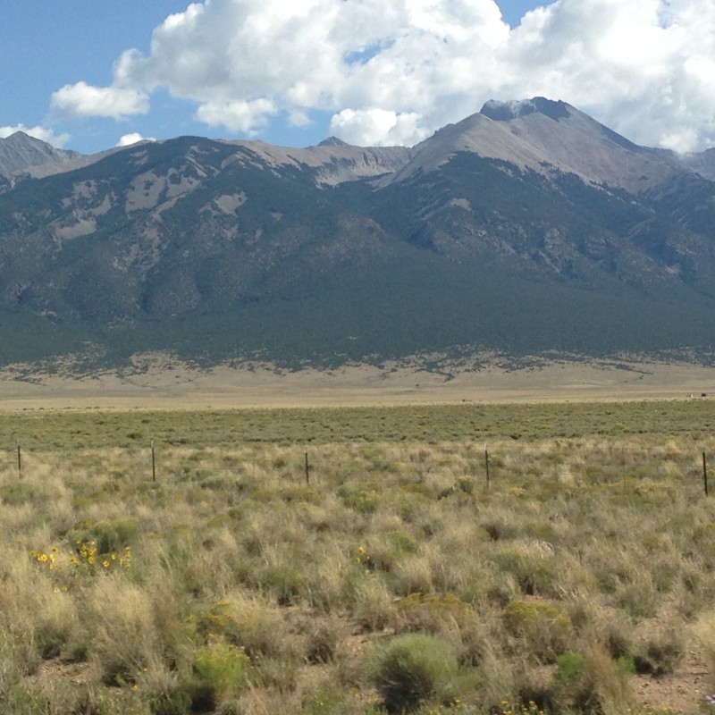 Note - this TR is from a climb more than a year ago, but I'd never gotten around to posting it, so here it is. I'm posting it as "current" for the off-season viewing pleasure of summer hikers like me, on a route that doesn't have a ton of beta. The 14ers of the Blanca Massif have always seemed like a forbidding group of mountains. Taking on the infamous Lake Como Road and the intimidation of Little Bear's Hourglass made it easy to leave those peaks for some future year. In 2016 we decided it was time. It was the âkid brother" of the three peaks that appealed the most to me: Ellingwood Point, by way of its southwest ridge. Our group has greatly enjoyed many of the other classic ridge routes on Colorado's 14ers - Kelso, Quandry's west ridge, Sneffels' southwest ridge, and others. This lesser known approach to Ellingwood point was just begging to be added to that list. Several excellent trip reports on this site whetted our appetite for this route, but it was really the homespun eloquence of Gerry Roach's 14er guide that sealed the deal. âThe ascent of this elegant ridge is pure fun," he wrote. âThe rock is solid, the Class 3 scrambling is continuous, the motion is fluid and there are no nasty notches or other surprises on the ridge. Follow one of Colorado's finest ridges for 0.7 mile to the summit" - proving once again that, in the words of Peggy Noonan, sometimes the right word is worth a thousand pictures. But first we had to get up that road. Driving very far up it in our Toyota Rav4 was out of the question, but because it is 4wd we thought we could nurse it to the pulloff area at 8800 feet, and maybe further based on a recent post stating the lower half of road had been improved. That plan dissolved quickly as Mark crept up the long straight and very rocky stretch sometimes referred to as the infamous âbabyheads." Every thunk and clunk reminded us that the vehicle taking this abuse had to get us back to Illinois. We decided to pull over and park it depressingly short distance past the 2wd trailhead, well below the 8800' mark. 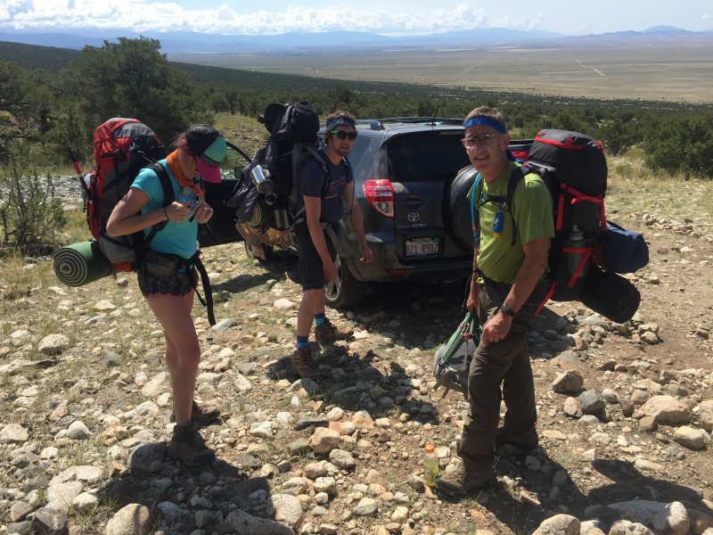 We hadn't started as early as we should have, despite having read ample warnings about the heat factor of this road, and sure enough, it got very hot very quickly. But a slow, steady pace put a couple miles behind us, easily measured by convenient roadside markers stating the distance left to the lake. We plodded above the barren lower section into a wooded stretch which provided merciful relief from the sun. Just about the time I started thinking, this isn't as bad as everyone seems to say, it became apparent that Dennis - the young, strong iron man of our group who always carries the heaviest load - was suffering from some kind of stomach bug from a wedding the weekend before. He lagged behind us, the opposite of our normal order, and when we he caught up at a break spot, dropped his huge pack with a groan. We all got pretty concerned, because he was carrying the beer, and we knew none of the rest of us were up to lugging all that weight up to camp. We basically told him to suck it up and keep moving, which he did. When we took a second break in the trees, still a long way from the lake, a light drizzle started. It felt disconcerting, but I kept telling myself, "it's only a little rain." We put the rain gear on ourselves and our packs and kept plodding. The miles kept dragging on, very slowly now. I convinced myself that the rain provided welcome relief from the heat. Then Maryjane, who had moved out ahead of the rest of us, returned back to the group to report that she encountered a howling wind up over the next rise. When we marched into it, a bone-chilling cold assaulted our bodies and our psyches. Efforts to don warmer clothing were only partially successful, as the simple act of stopping to pull fleeces and sweaters from deep within our packs was a struggle in itself. We put our heads down and kept moving. We had each turned back short of our summit goal only two or three times in 25-ish attempts on 14ers, but this was the first time I had ever wondered if we would actually make it to our campsite. I felt pretty foolish struggling forward with inadequate rain gear and chattering teeth. We'd been doing this long enough we should not have been surprised by afternoon rains in the mountains, or by howling winds roaring down a mountain valley. But there we were. Thankfully, our time hiking through wind and rain was relatively short, though it seemed to drag on when we were in the thick of it. But soon enough the lake and its westerly campsites came into view, and with it, relief from the worst of the wind as the trail descended toward the lake. More importantly, the shack there proved to be unoccupied other than holding a few pieces of somebody's gear. We piled in and huddled together in the one corner with a relatively intact roof, laughing at our miserable condition. Given the circumstances, that shack seemed like a five-star hotel to us. Eventually the rain stopped and we set up camp. Dennis seemed to be feeling better, but Maryjane had now caught whatever he had. She ended up spending most of the night in shivering misery. Mark and I took a late-day scouting trip up the basin above Lake Como, to view the next day's objective.  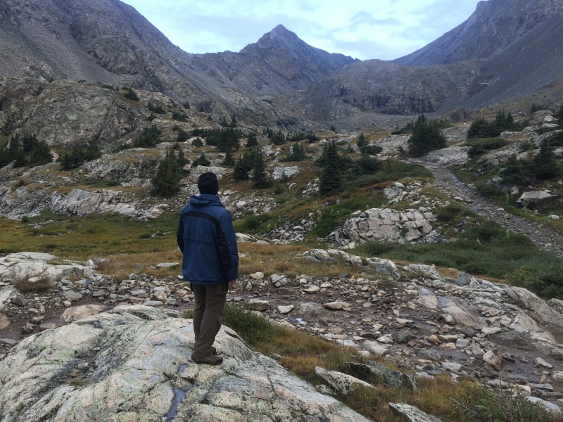 When the hour arrived to head for the summit, it was clear that she was not up to it, and therefore Dennis, like the good man that he is, would be staying behind as well, with her. Mark and I set out at 5 a.m. It took us an hour to hike past Blue Lakes, to the base of the waterfall there. In another 15 minutes we stood at the top of the waterfall, studying the south slopes of Ellingwood's southwest ridge for our ascent route.  We waited there about 15 minutes to let the morning light reveal our route up. The 14ers.com route description directs you to a "Y" shaped gully to ascend to the crest of the ridge, but Mark had spotted in other trip reports what seemed like a better ascent route a little west of that gully. We could see a shallow "S" shaped ascent described in a TR by USAKeller from quite a few years ago: Up the talus at the base of the slope to the right of a small cliff band, then bending back left to gain the beginning of some clearly visible ledge formations. The ledges conveniently sloped upward back to the right, forming obvious ramps toward the crest of the ridge. From our vantage point at the top of the waterfall, the lower section of scree looked like it might be a loose, miserable mess. It turned out to be surprisingly consolidated and solid. A streak of reddish gravel in the middle looked worth avoiding, but the gray rock to either side of it was easy going. Mark went left of that reddish scree, I went right, and we met above it, at the base of the ledges, in a matter of a few minutes. 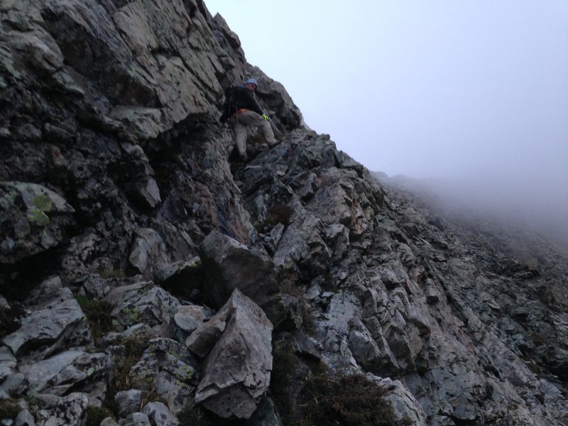 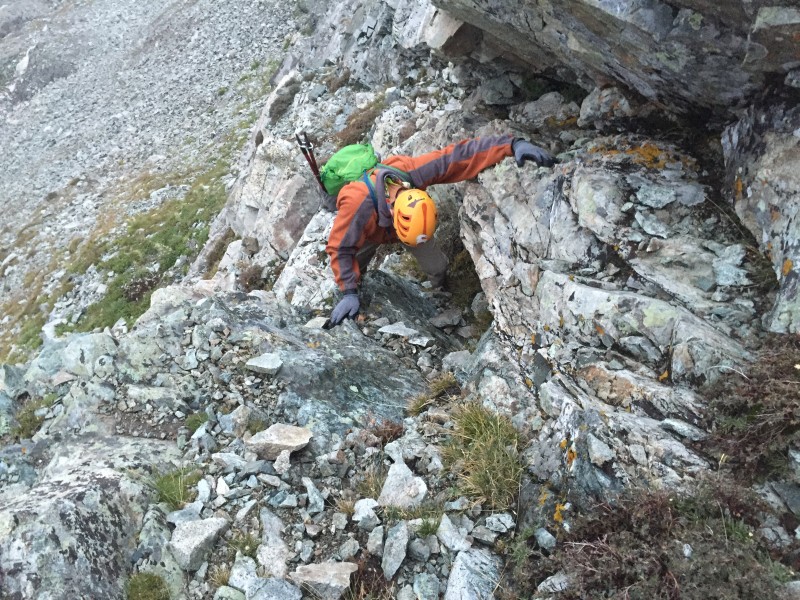 The ledges provided multiple ramps toward the ridge crest, somewhat reminiscent for a brief period of the Bells ledges on Pyramid that we had scaled the year before. As on Pyramid (and Eolus also for that matter), breaks in the ledges also presented options to go more straight up to the ridge. The ramps were easy, and led east toward the summit, but the appeal of the climb took over. In typical fashion, Mark soon chose to go straight up, and I followed by a slightly easier path. It took us about a half-hour to ascend from the top of the waterfall to the ridge crest.  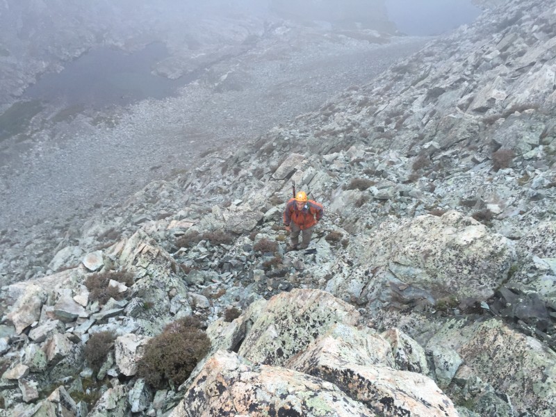 Once on the ridge crest, the route was obvious, although it required a little faith, since the upper ridge was socked in with low-lying clouds. We traversed east along the ridge, over minor ups and downs. The first discernible feature was a small gash that marked the top of the "Y" gully identified in the 14ers.com route description. Looking down the long run of rubble in that gully, I had to believe the ledges approach that we took was a better way to gain the ridge. The real fun kicked in shortly after we passed the top of that "Y" couloir. A rise in the ridge provided the first of many fun, solid class 3 scrambles. It was steep enough to provide exhilarating exposure, but nowhere did it feel risky. Route-finding was generally simple. At one point early in this stretch, the terrain seemed to offer an inviting traverse to the left, along the north side of the ridge. Mark, in the lead as usual, was interested in following that traverse; but I convinced him to head for the ridge. We had on occasion made other 14er ridge routes (Castle and Windom) harder than they needed to be by following misleading side trails. Knowing that this ridge offered no impassable obstacles, we simply took to the crest of the ridge and generally stuck to it all the way to the summit. 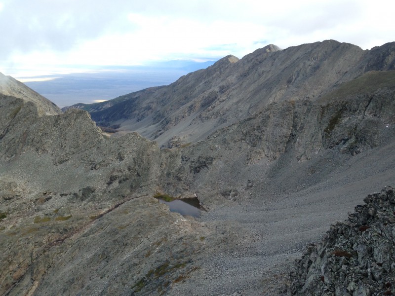 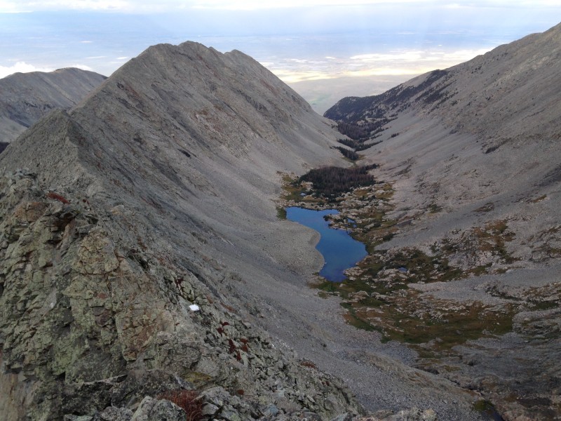 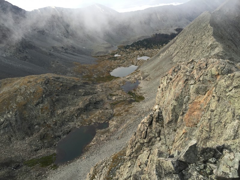 Clouds had settled in on the upper reaches of the ridge. We could often see what lay below and behind us, but ahead we could generally see only the rock tower immediately in front of us, with nothing but mist beyond. We would climb the visible tower, and upon reaching the top, find that the next one had appeared out of the mist. In between towers were often very short down-climbs and/or short straight stretches of ridge. 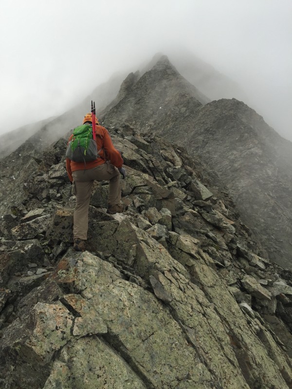  Many times the ridge narrowed to almost, but not really, a knife edge. There was nothing like the short knife edge on Kelso Ridge, where you place hands and feet on steep slopes on either side of the knife (or butt-scoot). On this ridge there was lots of air, but pretty much always with abundant features to grasp or step on, and sometimes short narrow sections that could be walked. 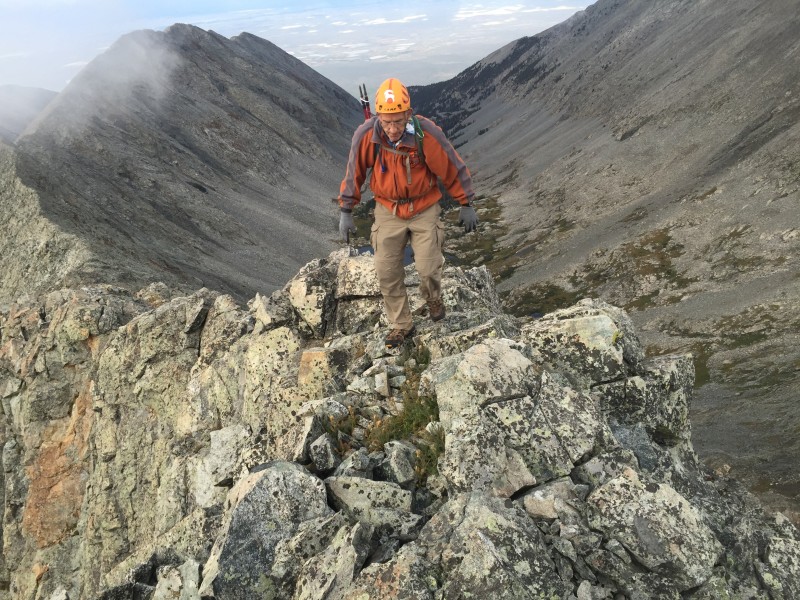 We kept ascending those towers, each time watching for the next one to appear before us out of the clouds. Eventually the mind started to wonder if maybe that next tower was the summit, but we knew to resist that thinking, because the mountain is almost always bigger than you think. Besides, it was too much fun to be anxious for an end. One especially large formation we recognized as the feature described as "the horn" in photo 19 of the route description. It's marked by some distinctive red rock near the base, a rarity on this route, which is otherwise almost all gray.   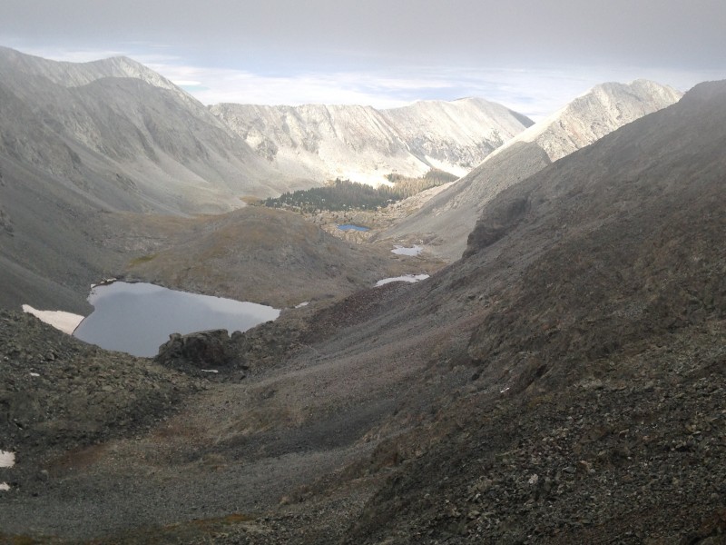 We knew this "horn" was indeed getting close to the summit, and it also appeared in research to offer some of the most challenging climbing. I would, however, personally describe the entire ridge as easy class 3 climbing, comparable in difficulty perhaps to the upper reaches of Wetterhorn or the southwest ridge on Sneffels. There is definitely a lot of exposure, but the rock was almost all quite stable and holds were abundant. And, although it has way more class 3 than Wetterhorn, it did not seem particularly long or difficult when climbed from our Lake Como camp. The next thing we knew, Mark and I were at the top, enjoying our 31st summit together. It was just after 9 a.m. Our "old flatlanders" pace had taken us two hours to go from our Lake Como camp to the crest of the ridge (including 15-20 minute wait for better light), and two hours along the ridge to the summit. 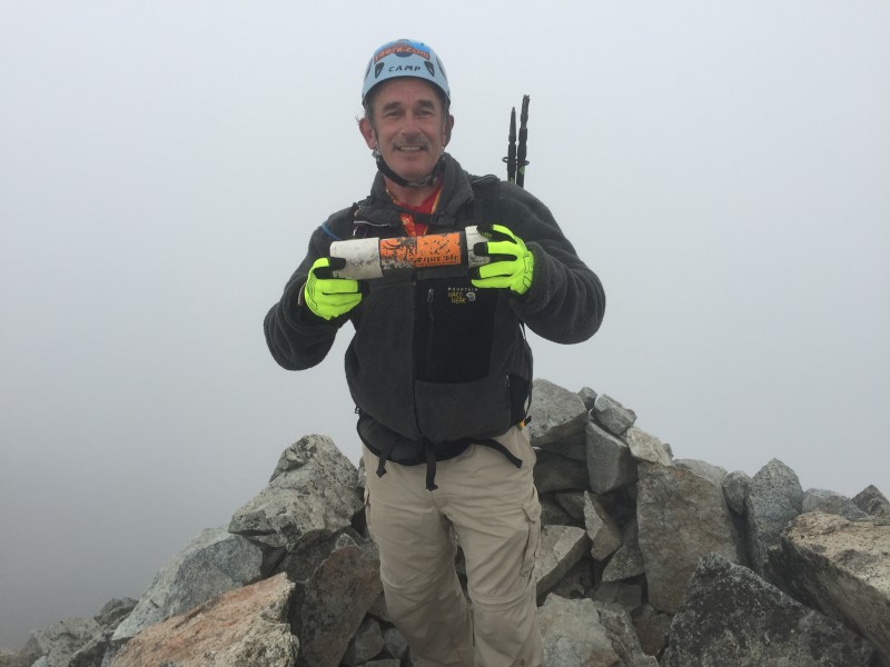 We had approached this venture with the idea of adding Blanca as a "maybe." By the time we summited Ellingwood Point, the clouds had lifted somewhat, providing some welcome sunshine and views. We felt fresh enough to start toward Blanca, knowing that we could change course and descend at one of several points along the way.  We decided to try following the ridge toward Blanca, rather than the multiple trail options beneath the ridge. It turned out to be harder than I expected. The first stretch had a trail, but when the trail dipped down and we stayed on the ridge, we found it to be slow going and the best route not apparent. Despite our efforts to stay on the crest of the ridge, we eventually found ourselves in some sketchy terrain along the west side of the ridge, potentially unstable and with some exposure. We exited that stretch into the prominent notch along the ridge. The low clouds had returned around us, along with a brisk wind. It was getting on toward 10. We had taken the better part of an hour to get this far from Ellingwood Point's summit, and a hefty ascent awaited if we wanted to summit Blanca. We decided one peak was enough for the day and headed back to camp. 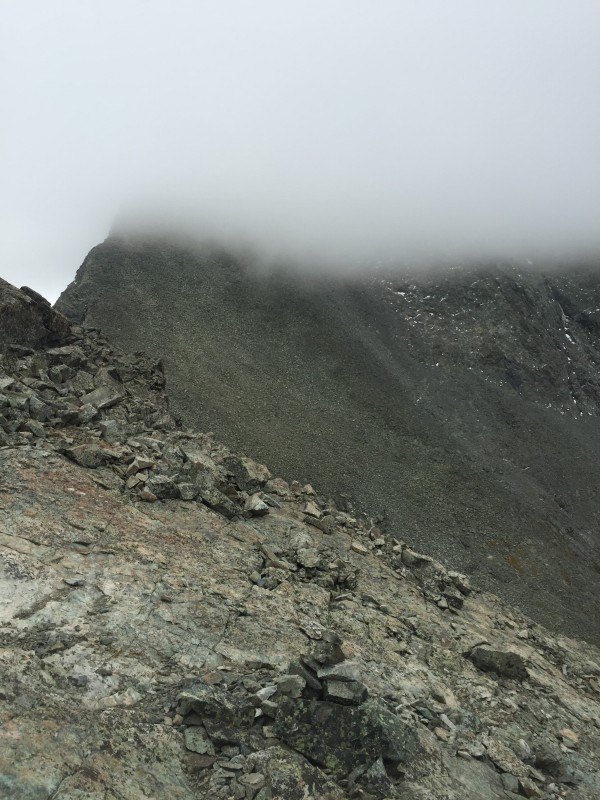 Dropping down from that notch meant off-trail talus hopping until we could pick up the standard trail. It took us quite a while and a significant descent before we found the trail, in the grassy ledges not far above Crater Lake. I am trained by now to be a bit concerned whenever I'm not on an established 14er trail, but in this case the incline was gentle and the talus relatively stable. I think we might have crossed over the standard Ellingwood Point trail at some higher point without noticing. It's easy enough to miss a wear pattern that may not be very prominent, or cairns to your left or right, when your focus is on the terrain ahead of you.  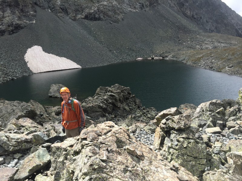 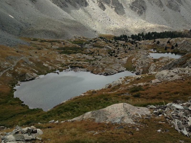  Back at camp we found Maryjane feeling a little better but clearly not her usual sunny self. We made plans to take a run at Little Bear the next day, but overnight rains persisted well past our planned morning start time. Taking on Little Bear in wet conditions with at least one person in our party not feeling 100% didn't seem like a good idea. Ellingwood Point would be our only summit this weekend.   The weather cleared for us on the walk down, a welcome turn of events. Despite all the hate heaped on the road, I found it relatively pleasant and the views beautiful. That was probably due in no small part to the fact that we did it as a liesurely descent direct from our Lake Como camp, not fatigued from a summit climb. 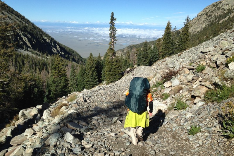 A few glances back in the vicinity of LB seemed to show clouds persisting in the high elevations well into the morning, which actually made me feel better about our decision to descend. We were hiking out on the Saturday of Labor Day weekend, a very intentional effort to avoid the massive crowds. And crowds there were. I didn't keep a count, but I think we passed at least 50 vehicles and I'd say 150 people coming up the road as we descended. By afternoon the peaks were cloud free and gleaming in brilliant sunshine; but by then we were playing tourist in Fort Garland.  As I post this, 2017 has turned out to be the first year since 2007 that Mark and I didn't summit a Colorado 14er together. We have no regrets about missing this year, however, because the year marked a more important milestone: Maryjane and Dennis were married in Estes Park in a celebration that was pure magic in every way inaginable. Dennis did manage to get in on a Kelso Ridge ascent of Torrey's and Gray's in September, and we all hold out high hopes of standing together at the top of a new 14er in 2018.  Thumbnails for uploaded photos (click to open slideshow):
 Shallow")
|
| Comments or Questions | |||||||||
|---|---|---|---|---|---|---|---|---|---|
|
Caution: The information contained in this report may not be accurate and should not be the only resource used in preparation for your climb. Failure to have the necessary experience, physical conditioning, supplies or equipment can result in injury or death. 14ers.com and the author(s) of this report provide no warranties, either express or implied, that the information provided is accurate or reliable. By using the information provided, you agree to indemnify and hold harmless 14ers.com and the report author(s) with respect to any claims and demands against them, including any attorney fees and expenses. Please read the 14ers.com Safety and Disclaimer pages for more information.
Please respect private property: 14ers.com supports the rights of private landowners to determine how and by whom their land will be used. In Colorado, it is your responsibility to determine if land is private and to obtain the appropriate permission before entering the property.


