| Report Type | Full |
| Peak(s) |
Half Dome - 8842 |
| Date Posted | 10/07/2017 |
| Date Climbed | 10/05/2017 |
| Author | painless4u2 |
| Half Dome Cables: Life After Surgery |
|---|
|
It has been an interesting past 2 years. First, a fall that blew out my right rotator cuff and bicep attachment, requiring surgery and a lot of time healing. Then, progressive difficulty walking, finding out my spine is shot, then surgical fusion of L4-5 with titanium rods and screws. And a lot more time healing. Needless to say, there wasn't much room for hiking or even staying in good physical condition, i.e., I got fat and lazy for 2 years. Being 63 also makes recovery a bit slower and doesn't help matters. Well, that's my excuse anyway. Living an hour away from Yosemite, I felt the call of Half Dome Cables route. This was one of those "bucket list" hikes I'd always read about and considered through the years, never sure when to try it. I'm not a technical climber, so this seemed about as close to the idea of using protection as I'd get. As a quick summary of Half Dome, located in Yosemite Valley, California: It was considered unclimbable in 1865, but was then first ascended in 1875 by George Anderson. Today, it has become the definitive day hike in Yosemite, so popular that a lottery system has been instituted allowing a maximum of 350 people per day. The route can be accessed via the Mist Trail (14.2 miles RT), the Muir Trail (16.5 miles RT), a combination of the two (about 15.5 miles RT), or from Glacier Point and the Panorama Trail (20 miles RT). Elevation gain from Happy Isles Trail Head is 4800'. So, around 15 miles RT with almost 5,000' feet elevation gain makes it similar to Longs Keyhole Route (minus the altitude) for comparison. Getting the lottery permit isn't easy, so I picked a end-of-season time during the weekdays, which worked (it helps living close by). Also got a reservation at one of the tent-cabins in Half Dome Village (formerly Curry Village) for the night before. This put us within a mile of the Happy Isle Trail Head, adding 2 miles RT to our mileage but making a quick start possible. Those little cabins are actually pretty comfy and worked well for us. They only have a single light and no plug outlet, so be aware of that if planning to charge up something. We utilized our arrival day to see a few sights and hike the Sentinel Dome/Taft Point loop, off Glacier Point Road. This gives you a great view of Yosemite Valley below along with surrounding high points. It's also a good way to get an idea of things to come. Taft Point is like Glacier Point, only without the crowds or the barrier walls.  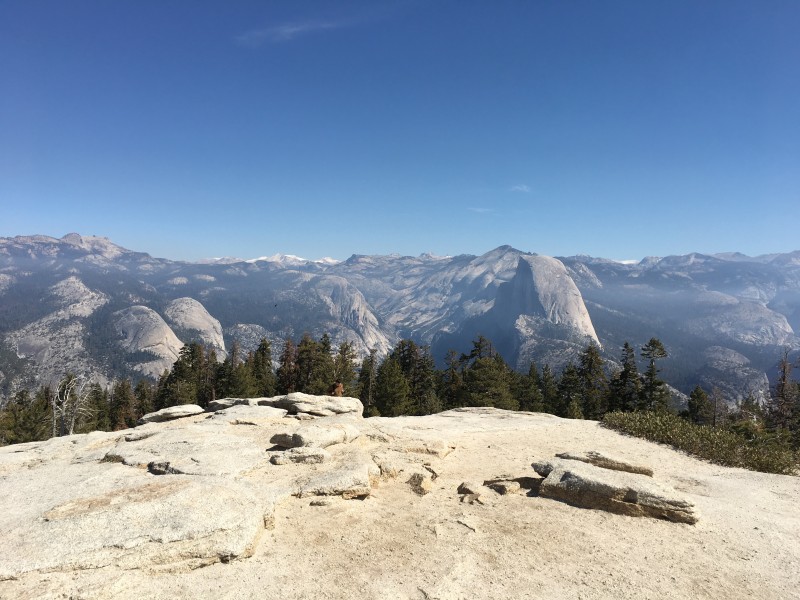  On the following day, we decided on going up the Mist Trail towards Half Dome, which ascends along the side of Vernal and Nevada Falls, both beautiful sights. It requires going up endless stair steps and when crowded, can be tricky, especially when wet. In October, the water coming down the falls is reduced, so the trail wasn't wet. Leaving at 6:00 am you (mostly) avoid the masses going up, which is nice. 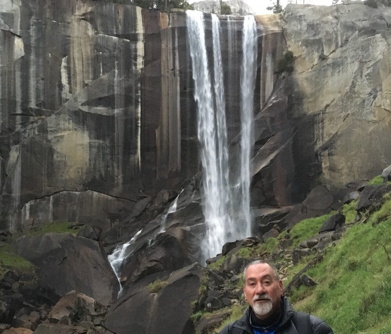 Once above Nevada Falls, you reach the Little Yosemite Valley (LYV), where you can backpack to and camp, if desired. This saves you the initial mileage going up for an even earlier start and beating the crowds up the cables, but requires hauling a backpack up those stairs and another permit. There is also a ranger station located in LYV. We didn't see a ranger until on our return toward the LYV, who did check our permit (and ID). The hike through LYV is flat and pleasant, a nice break from all of the stairs. Then you start switchbacking up out of the valley to the ridge below Half Dome, follow the ridge until the views open up and you see Sub Dome, with Half Dome behind. 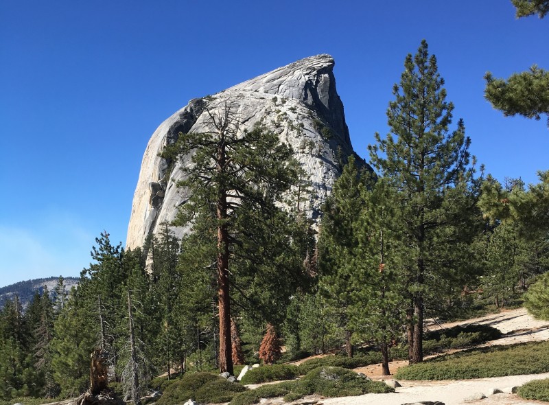 Sub Dome is a steep staircase hike which gives you a decent workout in preparation for Half Dome. Once on top of Sub Dome, the 400' of cables are in full view. As Gerry Roach likes to say, "it is here you will consider your future". 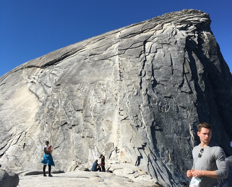 I expected it to be steep, maybe similar to the Homestretch on Longs, but not quite THAT steep.  Getting down also presented it's own challenges. The crowds were getting thicker, so the 2-way traffic was worse. Most people felt more comfortable facing toward the mountain, going down backwards. I went facing out, but worked OK. It seemed a little scarier coming down, seeing the steep slope ahead and feeling the pull. Upper body strength was again required on most of it. Once at the base, it's a matter of retracing your steps back. We chose to descend the Muir trail, avoiding the stairs along the falls and the hoards of day hikers on the Mist trail. It adds about a mile or so, but is welcome to tiring legs. 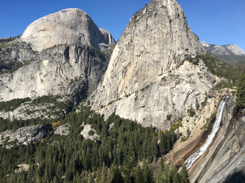 Most people take from 10 to 12 hours for the RT, so our time of 10.5 hours wasn't too bad for patched up old fogeys. We noticed the same people along the way who were much younger (likely 20 somethings) who would dart ahead of us, only to stop and fuel up and rest, while we would pass them, slowly making our way along without breaks. We all ended up summiting about the same time. All in all, a great hike in an iconic, beautiful place. For those of you contemplating major surgery and worried about being able to return to hikes like this, there is life after surgery! Just takes some dedication and working through some discomfort (like being barely able to walk for 2 days afterwards). Thumbnails for uploaded photos (click to open slideshow):  View of El Capitan from Sentinel Dome")
 Half Dome awaits")
 Recent rock slide on El Cap, leaving fresh scar. From Taft Point")
 Mike at Vernal Falls")
 On the ridge towards Sub Dome and Half Dome beyond")
 Half Dome Cables: Let's GO!")
 On top of Half Dome (Mike). Awesome day!")
 On our return along the JMT. Half Dome looms large")
|
| Comments or Questions | |||||||||
|---|---|---|---|---|---|---|---|---|---|
|
Caution: The information contained in this report may not be accurate and should not be the only resource used in preparation for your climb. Failure to have the necessary experience, physical conditioning, supplies or equipment can result in injury or death. 14ers.com and the author(s) of this report provide no warranties, either express or implied, that the information provided is accurate or reliable. By using the information provided, you agree to indemnify and hold harmless 14ers.com and the report author(s) with respect to any claims and demands against them, including any attorney fees and expenses. Please read the 14ers.com Safety and Disclaimer pages for more information.
Please respect private property: 14ers.com supports the rights of private landowners to determine how and by whom their land will be used. In Colorado, it is your responsibility to determine if land is private and to obtain the appropriate permission before entering the property.


