Download Agreement, Release, and Acknowledgement of Risk:
You (the person requesting this file download) fully understand mountain climbing ("Activity") involves risks and dangers of serious bodily injury, including permanent disability, paralysis, and death ("Risks") and you fully accept and assume all such risks and all responsibility for losses, costs, and damages you incur as a result of your participation in this Activity.
You acknowledge that information in the file you have chosen to download may not be accurate and may contain errors. You agree to assume all risks when using this information and agree to release and discharge 14ers.com, 14ers Inc. and the author(s) of such information (collectively, the "Released Parties").
You hereby discharge the Released Parties from all damages, actions, claims and liabilities of any nature, specifically including, but not limited to, damages, actions, claims and liabilities arising from or related to the negligence of the Released Parties. You further agree to indemnify, hold harmless and defend 14ers.com, 14ers Inc. and each of the other Released Parties from and against any loss, damage, liability and expense, including costs and attorney fees, incurred by 14ers.com, 14ers Inc. or any of the other Released Parties as a result of you using information provided on the 14ers.com or 14ers Inc. websites.
You have read this agreement, fully understand its terms and intend it to be a complete and unconditional release of all liability to the greatest extent allowed by law and agree that if any portion of this agreement is held to be invalid the balance, notwithstanding, shall continue in full force and effect.
By clicking "OK" you agree to these terms. If you DO NOT agree, click "Cancel"...
Starting Point: Horn Creek Trailhead: ~9,100'
Peaks Climbed in order of ascent: Little Horn Peak (13,143'), Fluted Peak (13,554'), Horn Peak (13,450')
Route: Northeast ridge ascent of Little Horn, ridge traverse to Fluted and Horn, northeast ridge descent from Horn
RT Distance: ~11.35 miles (from GPX file)
Elevation Gain/Loss: ~5,740 feet (from Google Maps)
Group: Solo
Horn Peak is easily the most prominent peak driving into Westcliffe from the east. It dominates the skyline even amongst the giants of the Sangre De Cristo range.
The Majestic Horn Peak
Climbing Horn Peak by itself from the Horn Creek trailhead would be a satisfying day's work. But if your goal is to get two, or better yet, three birds with one stone, all you would have to do is add the two neighboring peaks that form a majestic cirque around Dry Creek.
Dry Creek Cirque
The only question that remained then was which of the three would be first one up. I decided on the lesser traveled approach by tackling Little Horn's northeast ridge first. I figured the descent off Horn on a well-worn trail would be a good reward for tired feet at day's end.
Trail 1342 branches off the main trail, heading directly for Horn Creek and eventually to the lakes that it feeds.
TR 1342 is the one
Just over a half mile along the trail, I took leave of the trail to make my way up the treed hillside to gain Little Horn's northeast ridge.
This where I left the trail
Through the woods we go
Finding game trails made the job of weaving through the trees easier.
Game trails came in handy
Following the faint trail
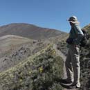
As I would soon discover, treeline on this ridge is not exactly an abrupt transition. The trees start to thin out around 11,500' affording the hiker the first view of Little Horn's northeast ridge leading to the false summit.
Almost at treeline
Almost...
But, the trees were far from done. The best path from here drops just south (hiker's left) of the ridge, meanders through the trees and undergrowth, and follows another game trail that eventually regains the ridge.
And we're back in the trees...
No prizes for spotting this one
The most resolute pines had defiantly staked their claim at 12,200' on the south slopes leading to the ridge.
Those pines don't give up
The lower part of the ridge to Little Horn has more than its share of rock outcroppings, all of which I safely bypassed on "tundra" firma.
Skirting the rock outcroppings
At 13,000', there is less than 150 vertical feet left on the climb, but the fun now ramps up by an order of magnitude.
Now the fun begins
The ridge narrows and a notch leads to a headwall that blocks passage to the false summit.
Headwall
I bypassed the notch by dropping to the south (climber's left) and skirting around some imposing rock formations.
Skirting around the headwall
I didn't have to skirt for long as I found a ramp that led me back to the ridge before the false summit.
Finding a ramp back to the ridge
The final pitch
One more hurdle separated me from an easy trudge to the first summit of the day.
One more hurdle
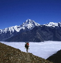
This may have been the lowest peak on this cirque, but it was a hard-earned summit. Views from this lowly 13er also did not disappoint. The smoke from the west coast fires that had filled the skies for weeks appeared to have been mostly dispatched.
The Crestones et al
Mt. Adams reaching for the skies
The winds had picked up through my ascent to this summit and were now blasting from the west straight toward me as I set out down the rocky ridge to the saddle with Fluted Peak.
Heading down to the saddle
The ridge to Fluted Peak is broken by ribs and riddled with rocky outcroppings, so the most efficient route stays below the crest; I hovered no lower than ~12,800' skirting most of the rocky ribs at their low points.
Staying just below the ridge crest
One of many rocky ribs
And another...
In contrast with the northeast ridge of Little Horn, the entire route to Fluted was rather tame and devoid of challenges; this would turn out to be case for most of the remaining ridge traverse for the day. Perhaps, I'd made a wise choice in ascending Little Horn first.
Contouring around the last of the ribs, I aimed for the high point on the ridge which turned out to be the confluence of three ridges at 13,400', one of which links with Adams Peak to the south.
Aiming for the ridge
Connecting ridge to Mt. Adams
From here the namesake flutes on the summit ridge were all that was left between me and the highest point of the day, which was atop the third flute.
The flutes of Fluted Peak
Any notion I might've harbored of staying on this summit was quickly dispatched by the raging winds that now showed no mercy; it was an incessant lashing from the west, and all I could think of was that I couldn't wait to get my back to that battering ram. Despite that, this was a special station in a special range, so I enjoyed the views.
Horn - Great and Little
Fall colors drape the valley
Closeup of the Crestones
Majestic Horn Peak was my next goal, so I started down the north ridge of Fluted, aiming for the point where it meets the west ridge of Horn. This ridge traverse was longer than the one between Little Horn and Fluted, but quite straightforward as I stayed on or just below the crest for the most part.
Ridge to Horn Peak
On the ridge crest
After skirting around one rock formation, I aimed for the highest point on the ridge.
Aiming for the high point on the ridge
After regaining the ridge, the Final pitch to the summit of Horn Peak was a relatively easy scramble over rocks.
Final ridge scramble
The winds were still blowing and it was clear my stay on this ridge was not going to get even remotely comfortable. But I had worked hard to get to this station and wanted to savor the fruits of my labor.
The previous two summits in the foreground; sheer ruggedness in the background
Closeup of Rito Alto to the northwest
My descent from Horn Peak was misguided as I figured I could shorten my return by aiming straight down the east slopes.
Heading down the steep east slopes
The terrain was steep and loose in sections, forcing me to re-evaluate my approach. I ended up doing a significant amount of sidehilling, passing a loose gully in the process and eventually connecting with the lower northeast ridge just above treeline.
Sidehilling around the gully
I was finally grateful to be on a trail instead of slipping and sliding over uncertain terrain. All in all, my choice of approach on this loop had played out well: a fun scramble up the first peak, an enjoyable ridge traverse to the second and third despite the nasty wind, rewarding views of the Sangres, and even an early glimpse into fall colors to boot. Not too shabby.
Fall is almost here
P.S. Upon further research and spurred by comments (see below), I've added what I believe will be a better descent option from Horn Peak: i.e. descending via its east ridge and eventually finding a good spot to descend north and cross Hennequin Creek and connect to the trail. I've shown this option in the image below in white. Alternatively, one may be able to drop south from lower on the east ridge and connect with the Dry Creek trail which would shorten the return trip even more. Some good options for the next adventurer to consider...
East ridge descent option shown in white
My GPS Tracks on Google Maps (made from a .GPX file upload):
I did this same loop earlier this summer! I chose to stay on trails though - took Horn Creek trail up to the Horn Lakes and ascended the grassy slopes of Little Horn. From there, just like you I stayed on the ridge to Fluted and the big Horn. But from Horn peak summit I dropped due South (ouch my knees!), and caught the Dry creek trail back to the TH. A bit rough of a loop to kick off the summer hiking season, but oh well.
Thanks, Doug! It was a fun outing, no doubt.
Natalie: Descending the south slopes of Horn doesn't seem too pleasant, but I can't imagine any loop being "rough" for you! :)
When my friend & I hiked this loop last October - we started the loop as Raj; bushwhacking to the ridge. Your pic 4 & 5 look rather familiar! After doing the loop which had plenty of fun, optional scrambling - we descended more or less as Natalie describes. Hitting the Dry Creek Trail just a bit below the farthest east lake. Thanks for the trip down memory lane! Nice TR!
TMTYS: Now that I've studied the terrain in some detail, it looks like descending via the east ridge (rather than the northeast ridge) of Horn would be a more expedient option to connect to Horn Peak trail. I've shown this in image 41, for what it's worth.
We followed the east ridge of Horn down, but instead of turning north and catching the rainbow trail (because it looked very willow bashing), we turned south and about 10200 caught the Dry Creek Trail. Super steep descent through the trees to the trail, and quite a bit of dead trees across the dry creek trail. But the east ridge was pretty easy and not too steep until you hit treeline.
nice report
Caution: The information contained in this report may not be accurate and should not be the only resource used in preparation for your climb. Failure to have the necessary experience, physical conditioning, supplies or equipment can result in injury or death. 14ers.com and the author(s) of this report provide no warranties, either express or implied, that the information provided is accurate or reliable. By using the information provided, you agree to indemnify and hold harmless 14ers.com and the report author(s) with respect to any claims and demands against them, including any attorney fees and expenses. Please read the 14ers.com Safety and Disclaimer pages for more information.
Please respect private property: 14ers.com supports the rights of private landowners to determine how and by whom their land will be used. In Colorado, it is your responsibility to determine if land is private and to obtain the appropriate permission before entering the property.


 The Majestic Horn Peak")
 Dry Creek Cirque")
 TR 1342 is the one")
 This where I left the trail")
 Through the woods we go")
 Game trails came in handy")
 Following the faint trail")
 Almost at treeline")
 Almost...")
 And we're back in the trees...")
 No prizes for spotting this one")
 Those pines don't give up")
 Skirting the rock outcroppings")
 Now the fun begins")
 Headwall")
 Skirting around the headwall")
 Finding a ramp back to the ridge")
 The final pitch")
 One more hurdle")
 The Crestones et al")
 Mt. Adams reaching for the skies")
 Heading down to the saddle")
 Staying just below the ridge crest")
 One of many rocky ribs")
 And another...")
 Aiming for the ridge")
 Connecting ridge to Mt. Adams")
 The flutes of Fluted Peak")
 Horn - Great and Little")
 Fall colors drape the valley")
 Closeup of the Crestones")
 Ridge to Horn Peak")
 On the ridge crest")
 Aiming for the high point on the ridge")
 Final ridge scramble")
 The previous two summits in the foreground; sheer ruggedness in the background")
 Closeup of Rito Alto to the northwest")
 Heading down the steep east slopes")
 Sidehilling around the gully")
 Fall is almost here")
 East ridge descent option shown in white")