Download Agreement, Release, and Acknowledgement of Risk:
You (the person requesting this file download) fully understand mountain climbing ("Activity") involves risks and dangers of serious bodily injury, including permanent disability, paralysis, and death ("Risks") and you fully accept and assume all such risks and all responsibility for losses, costs, and damages you incur as a result of your participation in this Activity.
You acknowledge that information in the file you have chosen to download may not be accurate and may contain errors. You agree to assume all risks when using this information and agree to release and discharge 14ers.com, 14ers Inc. and the author(s) of such information (collectively, the "Released Parties").
You hereby discharge the Released Parties from all damages, actions, claims and liabilities of any nature, specifically including, but not limited to, damages, actions, claims and liabilities arising from or related to the negligence of the Released Parties. You further agree to indemnify, hold harmless and defend 14ers.com, 14ers Inc. and each of the other Released Parties from and against any loss, damage, liability and expense, including costs and attorney fees, incurred by 14ers.com, 14ers Inc. or any of the other Released Parties as a result of you using information provided on the 14ers.com or 14ers Inc. websites.
You have read this agreement, fully understand its terms and intend it to be a complete and unconditional release of all liability to the greatest extent allowed by law and agree that if any portion of this agreement is held to be invalid the balance, notwithstanding, shall continue in full force and effect.
By clicking "OK" you agree to these terms. If you DO NOT agree, click "Cancel"...
Pt 12,903 (aka Moon Peak) on the Capitol Peak quad was my Pitkin County finisher and a worthy finale to that proud set of peaks. The main emphasis of this TR is to document the trail to Moon Lake, the approach to that peak and for the standard routes up the 13ers Clark, Daly and 13062. Several TRs try to describe how to find this trail; IMO, none do this well, leading to serious jungle thrashing. Having now made the passage between the West Snowmass Creek trail and Moon Lake basin four times, I think I've found a pretty solid means of finding the trail and staying on it.
Guidelines for finding and staying on the trail which should be used in conjunction with the GPX track attached to this TR.
To start with, the turnoff from the Snowmass Creek trail to the West Snowmass Creek Trail is mismarked on most topo maps. The turnoff is 1.5 miles from the trail head, further from the trailhead than the topos indicate, and is signed. Most, if not all times of the year, crossing Snowmass Creek to get to the WSCT involves wading across 40' of water that will be at least 1' deep.
All the previous beta that I'm aware of has you leave the WSC trail at 39.11.24,-107.03.567 (39.18734,-107.04278) and descend downhill towards the creek. I think you're better off staying on the WSCT for about another .1 mile until it switchbacks to the north; at this switchback another trail forks left/SW; this left fork is the better way to begin the Moon Lake trail.
Follow the upper MLT for about 1/3 of a mile until you reach a meadow that is about 100 yards wide. Probably the best option at this point is to walk halfway across the meadow then descend about 100' vertical and pick up another branch of the MLT. Follow this for about another .3 mile, paying careful attention every time the trail seems to end at a fallen tree -- the trail always resumes, don't settle for bushwhacking. Around 39.17749, -107.048112 it is tempting to descend south towards the creek; if you do this you will get mired in willows and marsh. Instead, make a point of finding a trail a little bit further west which contours around the marsh and eventually crosses to the south side of the creek at 39.17269,-107.05.
The trail above the creek crossing is much easier to follow.
On the descent from Moon Lake basin to the WSCT, instead of reascending the 100' in the meadow, you can stay low. The trail is quite indistinct if you do stay low but the bushwhacking is negligible and it should be pretty obvious how to return to the WSCT.
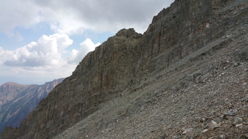
To climb Moon Peak, leave the trail around 39.1674,-107,0485 (11,100') and head S up steep talus which is large, loose and dangerous is you don't get lucky with your line. Around 11,600' you should gain a slight ridge heading SW where the walking is easier. What seems to be the standard route leaves the ridge around 39.39.1605,-107.0550 (12560') and heads east to a loose gully the terminates on the NE ridge of the peak, about 100 yards NE of the summit whence it should be class two to the top. On my ascent instead of taking the 3rd class gully, I continued on the SW ridge until it intersected the 12903/Clark ridge. From here I went directly towards the summit on 3rd, 4th and 5th class terrain to the top. This was a worthy way to finish Pitkin County (50 years after walking to Crater Lake, my first ever hike) but much harder and more dangerous than the 3rd class alternative which I took on the descent.
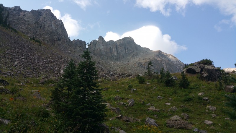
Moon Peak from about 11000' on the trail
Approx. ascent in red, descent in blue
3rd class gully to summit ridge
My GPS Tracks on Google Maps (made from a .GPX file upload):
No summit selfie? At least something cute warm and fuzzy preferable with black hair and chocolate brown eyes to look. Also, will this track work in winter? Did you leave any cairns in trees in case technology fails us? This trusted good info would've been good to have for my d/t of Clark same time last summer. Congrats on completing your Elks!
Caution: The information contained in this report may not be accurate and should not be the only resource used in preparation for your climb. Failure to have the necessary experience, physical conditioning, supplies or equipment can result in injury or death. 14ers.com and the author(s) of this report provide no warranties, either express or implied, that the information provided is accurate or reliable. By using the information provided, you agree to indemnify and hold harmless 14ers.com and the report author(s) with respect to any claims and demands against them, including any attorney fees and expenses. Please read the 14ers.com Safety and Disclaimer pages for more information.
Please respect private property: 14ers.com supports the rights of private landowners to determine how and by whom their land will be used. In Colorado, it is your responsibility to determine if land is private and to obtain the appropriate permission before entering the property.