Download Agreement, Release, and Acknowledgement of Risk:
You (the person requesting this file download) fully understand mountain climbing ("Activity") involves risks and dangers of serious bodily injury, including permanent disability, paralysis, and death ("Risks") and you fully accept and assume all such risks and all responsibility for losses, costs, and damages you incur as a result of your participation in this Activity.
You acknowledge that information in the file you have chosen to download may not be accurate and may contain errors. You agree to assume all risks when using this information and agree to release and discharge 14ers.com, 14ers Inc. and the author(s) of such information (collectively, the "Released Parties").
You hereby discharge the Released Parties from all damages, actions, claims and liabilities of any nature, specifically including, but not limited to, damages, actions, claims and liabilities arising from or related to the negligence of the Released Parties. You further agree to indemnify, hold harmless and defend 14ers.com, 14ers Inc. and each of the other Released Parties from and against any loss, damage, liability and expense, including costs and attorney fees, incurred by 14ers.com, 14ers Inc. or any of the other Released Parties as a result of you using information provided on the 14ers.com or 14ers Inc. websites.
You have read this agreement, fully understand its terms and intend it to be a complete and unconditional release of all liability to the greatest extent allowed by law and agree that if any portion of this agreement is held to be invalid the balance, notwithstanding, shall continue in full force and effect.
By clicking "OK" you agree to these terms. If you DO NOT agree, click "Cancel"...
Alright guys I got an interesting read for you all, but I would like to say first off that I tried my best to decipher Furthermore's trip report of the Electric/Cathedral traverse he did in 2008, but I just had to see this stuff for myself. I did botch a lot of the line choices made on the traverse, but I got pics... sooo not even mad.
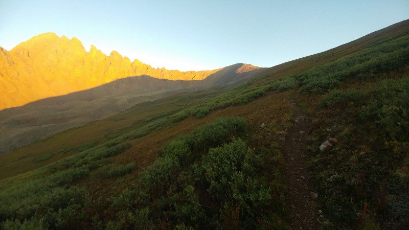
Anyway, I had parked in the Cathedral Lake parking lot and I woke up and left my car where I had slept in the back. It was cold as nuts and leaving the comfort of my cramped 4runner trunk was a difficult thing for me to do, but I rolled on out of there at 5:30am. The trail to the lake wasn't terrible which could have been because I was half asleep and so zoned out, but I made it to the Cathedral Lake/Electric Pass fork a little less than an hour later and took a right to go up the pass.
Hiking up Electric Pass, I was first aiming for Leahy (Lay-He for those wondering, spent a decent chunk of the morning trying to figure that out). The slope that Electric Pass is on is like a nice handicapped ramp among grass, very smooth and gradual which made it a short ascent. I ended up cutting off of the pass trail a little early to make the trip shorter.
I finally topped out at Leahy exactly 2 hours later from when I left my car on the dot, not too shabby I thought.
Leahy Peak
Yeah Leahy was cool, and the peak of any other mountain is cool I guess, but I was too stoked on hitting Cathedral later that I was only on the smaller summit for like 5 minutes before I took the ridge over to Electric Pass Peak.
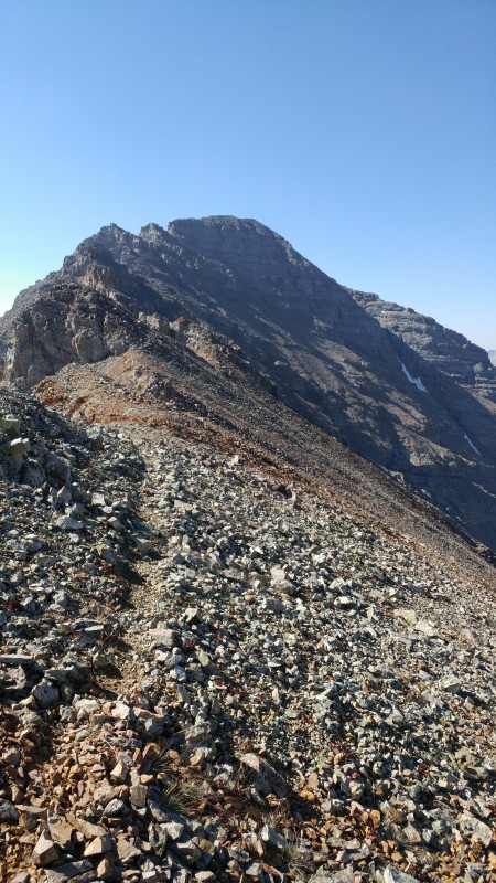
Ridge to Electric Pass Peak
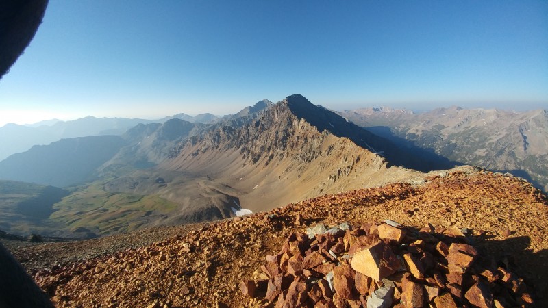
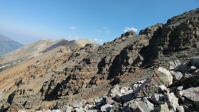
View of Cathedral ridge
The walk over to EPP took me maybe all of 15 minutes and that is where I ditched my helmet that I was planning on using later, along with 2 cans of ravioli to lighten up my pack a little bit for the hike over to Hayden, after all, I was going to be back on top of EPP again soon.
EPP summit
Look at Cathedral ridge
Let's see... The walk over to Hayden, hmmm, it's really not that great honestly. It is pretty out of the way and the ridge itself is kinda chunky so I had to stick below it on a very faint footpath walking among lots and lots off loose scree. Class 2+ just because there is like 1 part where you have to descend some larger boulders which could take some finesse.
Once on top of Hayden I pulled a Chevy Chase and looked around for like 5 seconds and nodded my head before I said to myself "Ok, let's go" then headed back again haha.
Coming back is where I got shafted by that footpath because I don't know if I wasn't paying attention or something, but there are 2 paths on the way back to EPP and I subconsciously chose the one that dropped a lot in elevation. I went for like 10 minutes and was like "wait why am I over 100 feet below the ridge??" I had to scramble back up some scree to the ridge again and then continue on my way. The total time it took me to check Hayden off from EPP and head back was about an hour and 10 minutes. Like I said, out of the way.
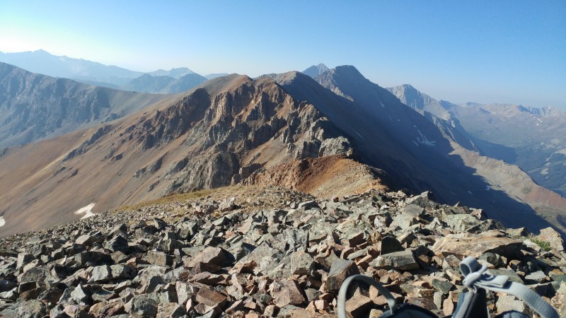
Ridge to EPP from Hayden
Back on top of EPP, I met a nice woman up there named Maria and I was very thankful that she did not eat my ravioli. Maria if you see this, I appreciate your company up there!
I grabbed my gear back and peeled out again from EPP about 10 minutes later, FINALLY getting to hit this traverse over to Cathedral.
Ok so... My main motivation for this was to not have to go way the hell out of the way to climb Cathedral from the standard route up the gully, AND to provide you wonderful people with some insight to this thing because I sure wished I had a bit more.
Pro tip #1: Just go ahead and take the L on trying to maintain elevation up near the ridge, do yourself a favor and just drop where it is convenient, otherwise you'll end up in a lot of situations where you won't know what to do because you're on the edge of a hefty cliff.
Pro Tip #2: If you faintly see something that looks like a cairn up on the ridge, I can 400% assure you it is, in fact, not a cairn
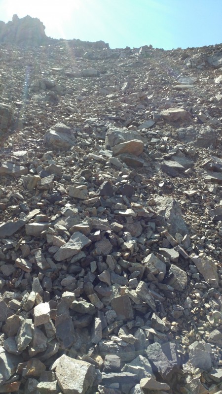
Pro tip #3: If you are not comfortable with loose Elk rock, this is not for you.
Alright so from EPP, obviously head along the ridge towards Cathedral for starters... There is actually a nice little footpath to show you where to go!
The footpath drops below to the West side of the ridge, (and now that I mention it, all of this is on the West side, East would be instant devastation) but continue on the path around the first large rock chunk.
Skirting along gendarme
Looking back
Once the path skirts around the rock wall shortly, it goes back up a small chute
Go up gully then head to the right
Once at the top of the chute, I was back on top of the ridge.
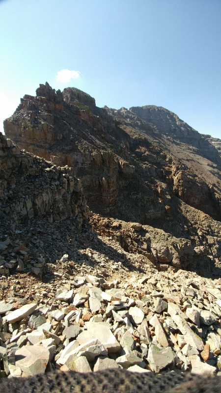
The path keeps going and winds around some more out croppings of rock
OK! This is where my day went pretty downhill (not even a pun). So you got this nice path that you have been friends with for awhile now because it is the only thing showing you where to go, but suddenly this stupid path breaks into 2 paths out of nowhere. One goes high, and the other seemed to switch back way way low.
Where footpath breaks into two, I went under that spire back there
I picked the high one because I was thinking 'pshh why would I want to lose all of that elevation?' Well that probably wasn't the best idea but I went with it and later had no choice to undo it.
Sticking high, I was forced to have to deal with a bunch of steep gullies and rock spines. Several of them just kept coming after I got out of the last one.
I was having to do a lot of weaving in and out and in and out of these gullies/spines along small ledges for the most part
Little ledges
I know this next pic doesn't make the terrain look too menacing, but that footpath ended between those two gendarmes and I was winging it from there.
And at this point, you may be reading this and thinking 'why doesn't he just keep walking down the mountain and gain the elevation later?' And I answer that by telling you that in a lot of cases up there, the rock spines and gullies went what seemed to be over 1000' down and there was no telling if any short cliffs existed down there as well.
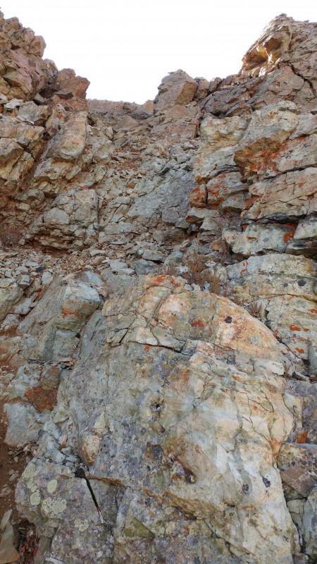
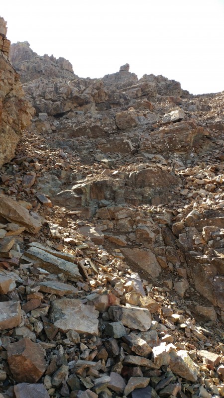
I ended up at this really narrow gully with massively steep walls and the only reason I was able to get down into it was because I found a weakness in the cliff wall somewhere down. I climbed up the gully and did some short class 3 moves to get back on top of that cliff wall to the right.
I went up this then climbed a little segment of wall to the right to get on top of the cliff
When I was on top of this spine, the view kind of opened up and I saw one of the rather large notches carved into the ridge, so of course I walked over there to check it out
Notch
After whipping out a few more class 3 moves to drop into that notch, I kept going and the terrain turned into really blocky loose rock.
Negotiating that took me awhile and after that was over was about the time where I reached my 'I don't even know what to do now' moment.
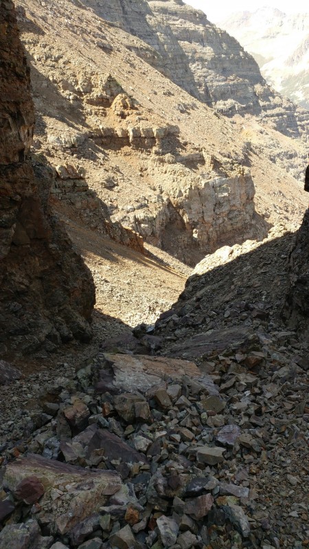
I came up to another notch which seemed normal at this point, but the rock on the other side was just all cliff and I had no way of accessing the other side of the gully that came from it
LARGE cliff walls to deal with
I was staring at it for like 5 minutes but then realized there was no way I was getting across this, at least right in the spot where I was. I started walking down the loose talus that I was on trying to find a break in the cliff for me to at least get down into that gully, and luckily I was able to find one maybe 150 feet down.
Now I was in that gully with cliffs on either side of me, bur at least I had a way down and out
Going down gully between cliff walls that I found a way into
Out of the gully, THIS IS WHEN I SAW THE LIGHT AT THE END OF THE TUNNEL
Ok I saw this majestic orange ramp out in the distance, and even better, the terrain up from the ramp actually just looked like a scree slope which was awesome at this point. Onward to the orange ramp I went, and if you are on this traverse and see this ramp, you must go there.
ORANGE RAMP
ha ha ha... finally... something normal
Calm slope
I kept going up the slope avoiding the stuff to the right, basically trying to get the ridge back because I was pretty close at this point
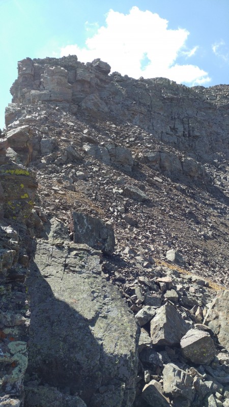
Once at the ridge, I had one last final obstacle ahead of me which was the class 3 wall shown in Furthermore's report. Be careful because if you fall, you will be rolling awhile.
Walls over there
Wow ok cool the hard stuff was done with! On top of that wall, I enjoyed a nice hassle-free stroll to the summit
Looking back, don't let this fool you
Once on top of Cathedral, I think it took me like 2 and a half hours, but I felt pretty accomplished not gonna lie.
I left and went down the SW gully soon after which was so freaking loose and steep, but still better than the ridge.
I ended up snagging Malemute too today which was nice and that let me be able to check off five 13ers, so not a bad weekend spent.
As for the ridge, I would not do it again but I hope that the photos and stuff prove helpful to those who were looking for some info on it
Thumbnails for uploaded photos (click to open slideshow):
Well-written Trip Report too. Thanks so much for posting the quality 13er route beta. Excellent work with reaching all those classic Elk Range peaks. Way to go on a stellar outing. Information regarding these types of Colorado mountaineering lines is great having. Keep climbing safe, smart, and strong
Thanks jasayrevt, I knew it was about time for there some info on this line! I should have another report soon for White Rock and White Rock BM, another lesser climbed series of peaks in the Elks.
There are no TRs on these peaks when dry because they are heinous without snow. In spring they get skied every day by aspenites and are classic spring skis found in many guidebooks.
https://www.wildsnow.com/600/600/
wish I had found your TR before attempting! I too was going off Furthermore's report and I ended up bailing about 1/4 mile from the summit, when I hit a point where it was clear I would need to descend a good ways down loose, steep gullies, toward the wrong drainage, in the hopes of finding a ledge system invisible from above... not a tempting prospect as a solo climber. now I am tempted to go back, knowing there lies an orange road to personal redemption.
Caution: The information contained in this report may not be accurate and should not be the only resource used in preparation for your climb. Failure to have the necessary experience, physical conditioning, supplies or equipment can result in injury or death. 14ers.com and the author(s) of this report provide no warranties, either express or implied, that the information provided is accurate or reliable. By using the information provided, you agree to indemnify and hold harmless 14ers.com and the report author(s) with respect to any claims and demands against them, including any attorney fees and expenses. Please read the 14ers.com Safety and Disclaimer pages for more information.
Please respect private property: 14ers.com supports the rights of private landowners to determine how and by whom their land will be used. In Colorado, it is your responsibility to determine if land is private and to obtain the appropriate permission before entering the property.


")
 Leahy Peak")
 Ridge to Electric Pass Peak")
 View of Cathedral ridge")
 EPP summit")
 Look at Cathedral ridge")
 Ridge to EPP from Hayden")
")
 Skirting along gendarme")
")
 Looking back")
 Go up gully then head to the right")
")
")
")
 Where footpath breaks into two, I went under that spire back there")
")
 Little ledges")
")
 I went up this then climbed a little segment of wall to the right to get on top of the cliff")
")
 Notch")
")
")
 Right past that spire is a deep drop off that I could not cross on to the other side")
")
 LARGE cliff walls to deal with")
 Going down gully between cliff walls that I found a way into")
 ORANGE RAMP")
 Calm slope")
 Looking back, don't let this fool you")
")
 Walls over there")
")
")
")


