Download Agreement, Release, and Acknowledgement of Risk:
You (the person requesting this file download) fully understand mountain climbing ("Activity") involves risks and dangers of serious bodily injury, including permanent disability, paralysis, and death ("Risks") and you fully accept and assume all such risks and all responsibility for losses, costs, and damages you incur as a result of your participation in this Activity.
You acknowledge that information in the file you have chosen to download may not be accurate and may contain errors. You agree to assume all risks when using this information and agree to release and discharge 14ers.com, 14ers Inc. and the author(s) of such information (collectively, the "Released Parties").
You hereby discharge the Released Parties from all damages, actions, claims and liabilities of any nature, specifically including, but not limited to, damages, actions, claims and liabilities arising from or related to the negligence of the Released Parties. You further agree to indemnify, hold harmless and defend 14ers.com, 14ers Inc. and each of the other Released Parties from and against any loss, damage, liability and expense, including costs and attorney fees, incurred by 14ers.com, 14ers Inc. or any of the other Released Parties as a result of you using information provided on the 14ers.com or 14ers Inc. websites.
You have read this agreement, fully understand its terms and intend it to be a complete and unconditional release of all liability to the greatest extent allowed by law and agree that if any portion of this agreement is held to be invalid the balance, notwithstanding, shall continue in full force and effect.
By clicking "OK" you agree to these terms. If you DO NOT agree, click "Cancel"...
This is less of a trip report and more of a project description.
If I can just get off of this LA freeway
Without getting killed or caught
- Guy Clark (L.A. Freeway)
"In the late 1950s Carl Pfiffner spoke passionately about traversing from the Arapaho Peaks to Longs Peak along the Continental Divide. This project retains all of its original mystique and it the ultimate mountaineering adventure in the Front Range. The adventure can be extended by going from Berthoud Pass to Milner Pass. There are many variations to this complicated project and any attempt requires your creativity." - Gerry Roach, "Colorado's Indian Peaks Wilderness Area, Classic Hikes & Climbs" (1989)
Given this intriguing description in the most prominent mountaineering guidebook to the area, it's remarkable that this traverse has not seen more attention. In 1987, Roach & his wife linked Berthoud to Milner in a 2-week backpacking and peak bagging trip, but they did not stay on top of the Divide. Taking some liberty with Pfiffner's original idea, Roach dubbed this the âPfiffner Traverseâ. More recently, in 2011, Mark Oveson hiked from Milner to Berthoud in a quick time of 37h44m, but did not stay on the CD and do not bag all the peaks along the Divide (Mark called this "Fast Pfiffner").
I'm aware of only one person who has completed Pfiffner's original idea of linking the Arapahos to Longs along the CD. This giant project was done by Buzz Burrell on July 8-9, 2002. Burrell stuck to the Divide, only dropping down to bivy and collect water, and he summitted every significant and named peak (see below). The route requires some serious climbing, with several mandatory 4th and 5th Class sections. It can take years of trips to the area to learn all of the nuances of this challenging and complex route! To distinguish his project from Roach's "Pfiffner", Burrell called his route the "LA Freeway" - an irresistible name for sure! Over time the LA Freeway has achieve near mystical proportions among the few people interested in such things. Being one of those people (and very close friends with Buzz), the idea haunted me for years.
Buzz laid out the "rules" as follows:
"Uber-simple (as classic routes should be): Go from Longs to Arapaho (or vice-versa) staying basically on the crest. Climb what you see!
1) Climb every named summit â‘ can skip the Chessmen and the other nasty towers, beeline on the plateaus, skipping unnamed bumps on the ridge
2) Don't drop into any basin or descend significantly from any saddle â‘ this is a ridge traverse
3) Climb any route you want â‘ the North Ridge of Toll for example is fun, but you can traverse up the West Face instead â‘ same for Longs and Navajo â‘ just get to the top of every named summit going up from the saddle
4) It's fine to leave the crest to sleep or dodge lightning â‘ just stay above timberline, and follow thru-hiking rules by retracing yours steps back up onto the crest and restart from the same spot you left
5) It's OK to have support or do it self-supported (stash gear), but unsupported is most logical â‘ this isn't that far â‘ just do it
In short, in keeping with climbing tradition, bring yourself up to what the route requires, don't bring the route down to you."
Here's a list of the hard parts, with some of my personal notes:
-Longs: I prefer the quickest way, which is the North Face, 5.4
-Pagoda: The West Ridge is most direct, but goes at 5.7 - too hard for me! I've worked out 5.EZ sneak that goes down the South Face to a nice ledge system that's only maybe 100' lower than the Pagoda-Chief's saddle, though quite a bit farther east.
-Isolation: Roach lists the North Ridge as 5.0-5.2, but that's just BS. Fortunately, there's an easy sneak around to the west by descending 150' vertical on a grassy ramp, then up a steep, easy (Class 3) gully.
-Paiute North Ridge and North Face: The ridge is long and complex and nasty. I was only able to find 1 very cursory description on the internet, by John Prater, written 4 years after he climbed it! Prater says they traversed on the east side of the ridge, but that's just evil - narrow & extremely exposed grassy ramps (always wet), loose rock and arduous route finding. The west side seems generally much better, but has it's own idiosyncrasies. This is definitely something you need to scout. Once you get to the final headwall on the upper north slopes of Paiute, Prater says they climbed something at 5.6-5.7. We found a west facing 5.2ish corner - way easier. Scout!
-Toll: The standard North Face route on Toll goes at 5.6. I can tell you the crux chimney pitch is hard with a backpack as the chimney is very narrow! Bring a haul cord. Or you can do the Class 4 West Face route.
-Apache: The ridge north of Apache reminds me very much of the North Ridge on Pauite, without the easy west side option. I hate it.
-Navajo: North (or West?) face described in Roach's book, 5.2.
-Arikaree: Not hard, but illegal!
-North Arapaho: Tricky route finding but not hard North Ridge route described in Roach's book, Class 4.
So, anyway, I gave it a go starting at the Longs TH on 7/24. I muddled through Paiute on the first day, and bivied in the saddle between Paiute & Toll. Unfortunately, the weather wasn't great on 7/25, and it started to rain at 8:15am when I was on that sketchy traverse to Apache, which I didn't like, so I bailed out. So, as far as I know Buzz is still the only person to complete Pfiffner's visionary idea! Given that it's a short drive from the land of the Uber Jock (Boulder), it's remarkable that this route has not attracted more interest. I think this will change: I know of 2 very accomplished athletes who have the LA Freeway at the top of their "to-do" list. Game on!
I didn't take any pictures. I was too busy walking! Sorry.
UPDATE: Matthias Messner completed the LA Freeway on August 5, 2017, in a speedy time of 16h59m. His detailed trip report with splits is on the Ultimate Direction Blog.
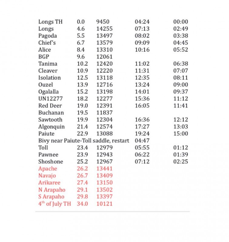
Distances are based on GPS up to Shoshone.
My best estimate for the total ascent of the route is 17,600'.
Thumbnails for uploaded photos (click to open slideshow):
You should never ask that question 2 days after...! But, I know myself & I certainly won't say that I will not try again. It's a really good route! I wanted to go earlier than later mainly because of water and daylight. I didn't discuss water, but it can be a problem on the Divide for obvious reasons. I actually found lots of water this time, but that won't be the case in a few weeks. However, with an apparently reliable water source between Ouzel and Ogalalla (it's been there every time I have), then maybe dropping off the Divide to bivy near water, then a good (clean!) lake just north of Navajo (shhhhhh!!!), there's probably enough water even later in August. As far as daylight, now I know I can do it in let's say two 12-hour hiking days, so that's possible even into the Fall. There's a credible attempt happening in about a week (weather permitting) - a person who has the ability to do this thing in a 1-day push. I'd love to see that succeed, as it takes the pressure off for someone (me?) to repeat this darned thing!
Kyle Richardson just did it in 16:29 on August 1, 2018. Looks like it's getting more interest...
Caution: The information contained in this report may not be accurate and should not be the only resource used in preparation for your climb. Failure to have the necessary experience, physical conditioning, supplies or equipment can result in injury or death. 14ers.com and the author(s) of this report provide no warranties, either express or implied, that the information provided is accurate or reliable. By using the information provided, you agree to indemnify and hold harmless 14ers.com and the report author(s) with respect to any claims and demands against them, including any attorney fees and expenses. Please read the 14ers.com Safety and Disclaimer pages for more information.
Please respect private property: 14ers.com supports the rights of private landowners to determine how and by whom their land will be used. In Colorado, it is your responsibility to determine if land is private and to obtain the appropriate permission before entering the property.
")


