Download Agreement, Release, and Acknowledgement of Risk:
You (the person requesting this file download) fully understand mountain climbing ("Activity") involves risks and dangers of serious bodily injury, including permanent disability, paralysis, and death ("Risks") and you fully accept and assume all such risks and all responsibility for losses, costs, and damages you incur as a result of your participation in this Activity.
You acknowledge that information in the file you have chosen to download may not be accurate and may contain errors. You agree to assume all risks when using this information and agree to release and discharge 14ers.com, 14ers Inc. and the author(s) of such information (collectively, the "Released Parties").
You hereby discharge the Released Parties from all damages, actions, claims and liabilities of any nature, specifically including, but not limited to, damages, actions, claims and liabilities arising from or related to the negligence of the Released Parties. You further agree to indemnify, hold harmless and defend 14ers.com, 14ers Inc. and each of the other Released Parties from and against any loss, damage, liability and expense, including costs and attorney fees, incurred by 14ers.com, 14ers Inc. or any of the other Released Parties as a result of you using information provided on the 14ers.com or 14ers Inc. websites.
You have read this agreement, fully understand its terms and intend it to be a complete and unconditional release of all liability to the greatest extent allowed by law and agree that if any portion of this agreement is held to be invalid the balance, notwithstanding, shall continue in full force and effect.
By clicking "OK" you agree to these terms. If you DO NOT agree, click "Cancel"...
This route is pretty straight forward but maybe there is some information that will help others doing this in late June.
This is a very short and very accessible route. At this time of year, you have to be off this route by 1p at the latest.
There was absolutely no one else on the couloir, given that there were probably 20 people on the summit and a line of people coming up the standard route, I thought it was a good alternative.
I had crampons and an axe, my partner had spikes and an axe. I would advise crampons, the ascent is fine but they were pretty helpful on the descent. The axe should be mandatory as well.
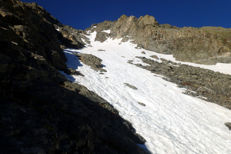
We arrived at the base of the couloir around 6am, the hike in from the car doesn't take more than an hour and a half. I was worried about snow conditions but they were great on the way up. Below is a good look at most of the route. View of most of the route
We crossed the lake and followed the climbers trail to the bottom of the couloir and put on our crampons. Below is a look up at the crux. Beginning snow travel, looking up at the crux
Start at the base of the snow and follow straight up. The crux as described in the route description is a 100 ft steep section right after the beginning of the snow climb. It gets pretty steep but it is manageable and very comfortable with the snow. Pictured below, this section is pretty exciting, after that it is a moderate slope all the way up. This is looking down at my partner coming up the crux. Another climber ascending the crux
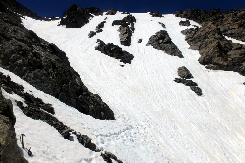
After the crux we followed the couloir up to just under the crest of the final summit ridge. Here you can make a decision. There is a rock buttress that split the snow field. The described route goes left, which would have required travelling over talus. We went right which went up another steep 50 ft. climb which was similar in angle to the 'crux' section. We did not descend this way.
We left the summit around 11:45pm, getting back near the couloir around noon. I immediately saw evidence of fresh slides in the middle of the coul. Followed by active slides, at least one every five minutes. We still descended, staying near the sides and descending one at a time to spot the other. The slides are not deep but troubling none the less. These slides occurred much more often at the top of the coul. Towards the middle and bottom, the angle was much more moderate and the snow more stable. Around 13,700
Descending the coul, I downclimbed facing the mountain, using the crampons to kick good holes for my partner with spikes. He still took his time and felt unstable without crampons here and I agree, it would be much more nerve racking. It took 4 hrs going up and 3 back but my partner was in spikes and new to snow travel so we went pretty slow. Coming down the crux
Overall,
The snow is deep enough but conditions deteriorate quickly in late June, start early.
Thumbnails for uploaded photos (click to open slideshow):
Not a lot of reports on this route and one I've entertained and will likely consider again. Nice work!
Caution: The information contained in this report may not be accurate and should not be the only resource used in preparation for your climb. Failure to have the necessary experience, physical conditioning, supplies or equipment can result in injury or death. 14ers.com and the author(s) of this report provide no warranties, either express or implied, that the information provided is accurate or reliable. By using the information provided, you agree to indemnify and hold harmless 14ers.com and the report author(s) with respect to any claims and demands against them, including any attorney fees and expenses. Please read the 14ers.com Safety and Disclaimer pages for more information.
Please respect private property: 14ers.com supports the rights of private landowners to determine how and by whom their land will be used. In Colorado, it is your responsibility to determine if land is private and to obtain the appropriate permission before entering the property.