Download Agreement, Release, and Acknowledgement of Risk:
You (the person requesting this file download) fully understand mountain climbing ("Activity") involves risks and dangers of serious bodily injury, including permanent disability, paralysis, and death ("Risks") and you fully accept and assume all such risks and all responsibility for losses, costs, and damages you incur as a result of your participation in this Activity.
You acknowledge that information in the file you have chosen to download may not be accurate and may contain errors. You agree to assume all risks when using this information and agree to release and discharge 14ers.com, 14ers Inc. and the author(s) of such information (collectively, the "Released Parties").
You hereby discharge the Released Parties from all damages, actions, claims and liabilities of any nature, specifically including, but not limited to, damages, actions, claims and liabilities arising from or related to the negligence of the Released Parties. You further agree to indemnify, hold harmless and defend 14ers.com, 14ers Inc. and each of the other Released Parties from and against any loss, damage, liability and expense, including costs and attorney fees, incurred by 14ers.com, 14ers Inc. or any of the other Released Parties as a result of you using information provided on the 14ers.com or 14ers Inc. websites.
You have read this agreement, fully understand its terms and intend it to be a complete and unconditional release of all liability to the greatest extent allowed by law and agree that if any portion of this agreement is held to be invalid the balance, notwithstanding, shall continue in full force and effect.
By clicking "OK" you agree to these terms. If you DO NOT agree, click "Cancel"...
Climbers Point (13,005 ft) Mount Solitude (13,090 ft) Vista Peak (13,075 ft)
Saturday, 24 June 2017
Route: Ascend Climbers Point from the group's west slopes via Pitkin Creek Trail > Traverse to Solitude > Traverse to Vista > Descend west slopes to Pitkin Creek Trail
Distance: ~11 miles R/T
Gain: ~5300 feet
The Solitude group stands along a ridge in the central Gore Range just north of Vail and Interstate 70. The base of its steep but gentle western slopes is traversed by Pitkin Creek. A trail leads from the town of Vail up along the creek to Pitkin Lake and provides a fantastic access point from which to climb these scenic mountains.
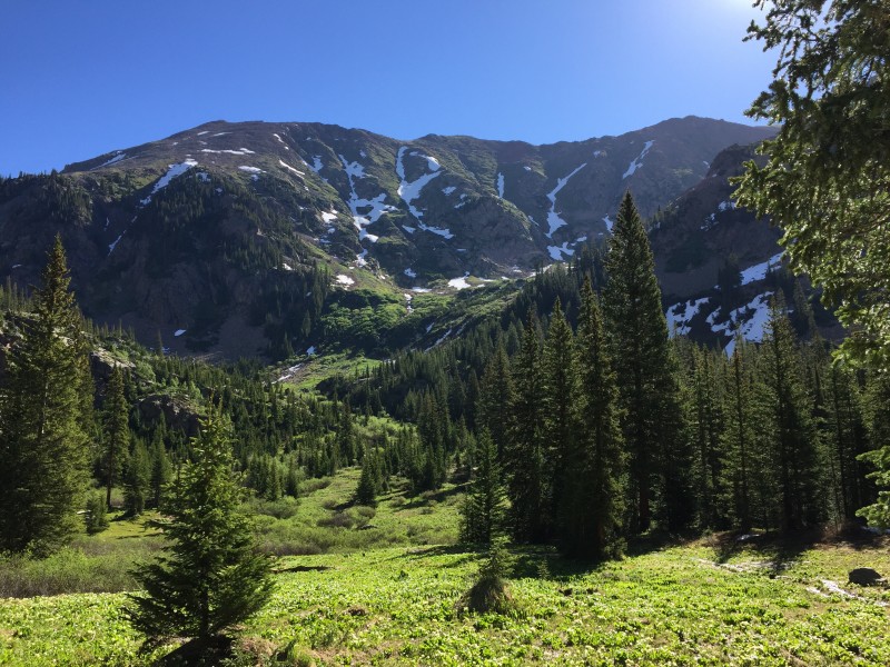
Annalise and I decided to head over to Vail on Saturday morning to give an attempt at the group. We packed up and were headed off from the Pitkin Creek trailhead at 7:15 AM. The Pitkin Creek Trail, in typical East-Vail-Lake-Hike fashion, started off gentle for about 100 feet, made an unnecessary jog back toward the highway, turned a corner, and then began a relentlessly steep gain of elevation, which continued for a little while until the sounds of the freeway disappeared and the grade flattened out. 3.5 miles up the trail, we reached the top of a small headwall. Directly to the east of this location is a great place to cross Pitkin Creek and ascend the choke point at the bottom of the Solitude group's west slopes. The USDA has an information sheet on the Pitkin Creek Trail. The PDF with a map doesn't like to be linked, but is easy to find via a Google search. The typical leaving point of the trail is the spot that's marked as "Falls" on the USDA trail map.
Approaching the solitude group along the Pitkin Creek Trail.
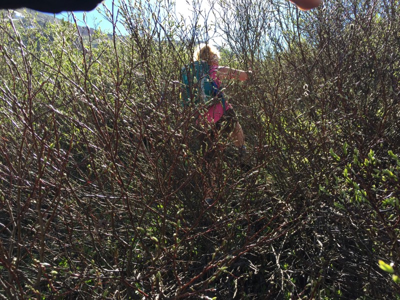
At about 9:00 AM, we jumped across Pitkin Creek and walked through the meadow, planning how to get through the bushwhack section. We took a route up to the right of the creek flowing down from the peaks, which necessitated minimal bashing of willows. The ascent up the initial steep section involved mostly zigzagging between willow outcroppings, the occasional spruce tree, and sometimes busting through dense combinations of both.
Part of our uphill bushwhack.
The whole ordeal only took several minutes, and before we knew it, we were walking across a mellow snowfield toward the meadows at the base of Solitude's steep upper slopes at about 9:30 AM.
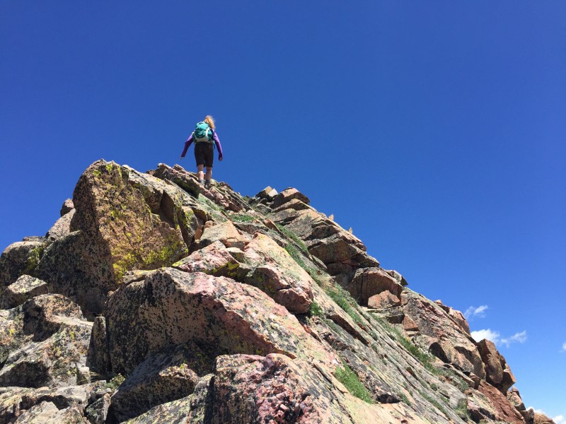
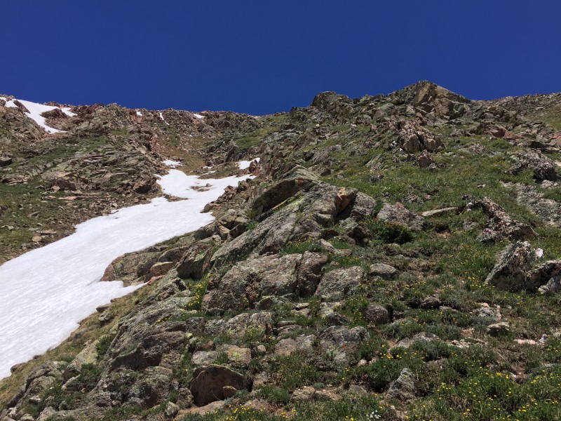
We decided to follow one of the grass ramps along a shallow gully directly to the east, located a bit to the looker's left if looking directly toward the center of the cirque. The grassy ramp provided one hell of a stairmaster workout, with options to throw in just a bit of class 2+ (or even easy 3) to the right at the rock rib for when we were feeling a little extra adventurous.
Our route went directly up the middle of the photo. I could edit out my sleeve, but I'm a bit lazy, and it feels more au
Rocky Gore Range views.
We went up the ramp a bit to the left of the snow in this photo.
Pardon my hand. The terrain was steep, so most pictures I shot while going up the slope were pointed almost directly at the s
Almost to the ridge, looking north toward Solitude (R) and Vista (L).
The grassy ramp deposited us on the ridge a little to the north of the summit of Climbers Point. We turned right (south) and began what we initially thought to be the final ascent up to the top.
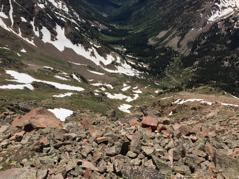
Looking down the east side of the ridge. Long way down!
Looking up what we initially thought to be Climbers Point.
Upon reaching it, we discovered that it's actually a couple minutes' walk farther south, which was confirmed after consulting the topo. After a hop, skip, and a jump, we were standing on our first summit of the day. The time was 11:15 AM, four hours after beginning our outing.
Precarious rock on the false summit.
The real summit from just past the false summit. Close!
The southern Gores from the summit of Climbers Point. Is this real?
The northern Gores from the summit of Climbers Point. I think it's real! Mount Solitude is hoarding all the snow, while Vista Peak stands directly to its left.
On the summit of Climbers Point, looking back toward Vail and the Holy Cross Wilderness.
After a few minutes, we left the summit of Climbers Point and re-traced our steps to the north. We descended to the saddle and walked up the south ridge of Mount Solitude. The traverse between the two summits was relatively quick and remained class 2. However, while grassy slopes lead downward to the west, the terrain to the east of the ridge crest provided some big exposure (and therefore some great views).
The class 2 ridge up Mount Solitude from above.
The class 2 ridge up Mount Solitude from below.
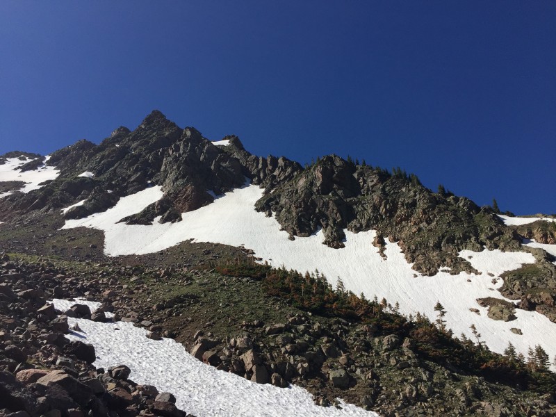
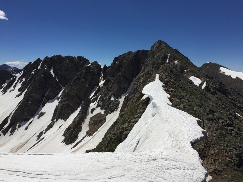
Climbers Point, featuring fascinating snow formations.
At 11:50 AM, we gained the summit of Mount Solitude, our second summit for the day.
The northern view from Snowm-uh, err... Mount Solitude.
These are our evil Millennial faces. I'm expecting a citation to show up in the mail for taking a selfie in the Gore Range.
We took a longer break on Solitude before continuing our northerly ridge traverse. Like before, we descended class 2 terrain to the Solitude-Vista saddle, then traversed a rocky false summit before heading uphill one last time in pursuit of our final summit.
Shortly after beginning the traverse to Vista Peak.
Looking back at Mount Solitude, still hoarding all that snow.
Fun ridge walk!
The closer we got to Vista Peak, the rockier the slopes to our west became. The terrain to the east continued to consist of, well, air. We reached our third summit at 1:00 PM.
Northern Gores from the summit of Vista Peak. A great opportunity to scope out Peak X.
Southern Gores from the summit of Vista Peak, including our traverse from Climbers Point on the right (but not the far right).
After another break admiring the incredible views, we began our descent at 1:15 PM. We re-traced our steps about halfway back toward Mount Solitude, holding out for grassier terrain on the west slopes instead of talus.
Too much loose talus here. Let's go farther south.
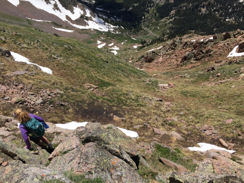
Once we scoped out a decent descent path, we started downward the steep western slopes. It was like walking down a grassy staircase, interrupted occasionally by sprinkles of rockier terrain.
Much better.
Our descent path goes approximately up the middle and a bit to the left.
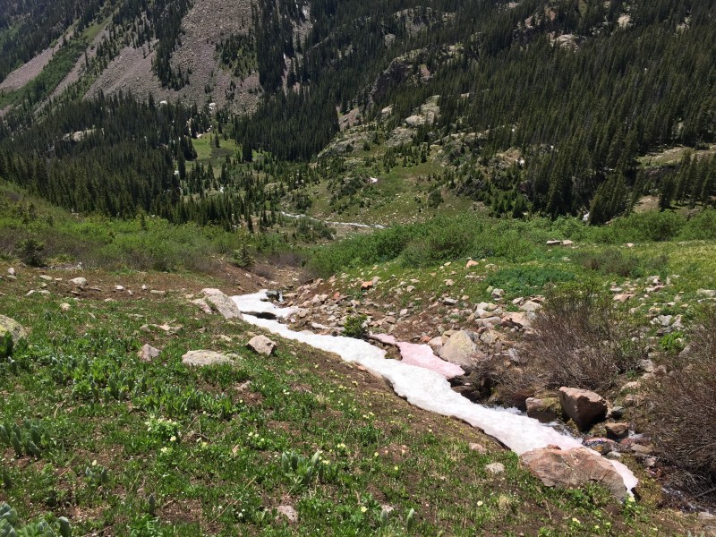
We reached the base of the steep slopes, crossed the mellow meadow, and found ourselves at the top of the choke point. This time, we opted to follow the creek we found until the route became no longer feasible, then wing it from there.
Here comes the little bushwhack.
Looking back at the steep west slopes of the Solitude group.
Well, wing it we did. The next picture explains it all.
Just let the pine enfold you.
Again, the bushwhack only lasted a few minutes, and we were shortly crossing the meadow between the choke point and Pitkin Creek. We opted to cross Pitkin Creek barefoot this time, letting our feet take a soak in the cold water. After a rest break on some comfortable rocks, we went back to the trail and continued the rest of our descent.
Some time passed, when suddenly, llamas.
So majestic.
We left the llamas to do their thing (they were certainly not there when we were walking up the trail in the morning) and made our way back, cursing the steep section when it arrived, and praising the raging Pitkin Creek when crossing the bridge near the trailhead, for the valley felt like an oven and the torrent brought with it a cool breeze. We returned to the trailhead at 4:35 PM after a great day.
For someone looking for an introduction to Gore Range peaks, it doesn't get much better than the Mount Solitude option. You will experience routefinding, a bit of bushwhacking, plenty of classic Gore steep grass, and nonstop incredible views. Thanks for reading!
~Tony
Thumbnails for uploaded photos (click to open slideshow):
I like those peaks! Good choice!
And Anna, if you haven't been in the northern Sawatch yet (Gold Dust area), you might be surprised at the similarities.
used it today, what a nice trail all the way until the bushwhack
Caution: The information contained in this report may not be accurate and should not be the only resource used in preparation for your climb. Failure to have the necessary experience, physical conditioning, supplies or equipment can result in injury or death. 14ers.com and the author(s) of this report provide no warranties, either express or implied, that the information provided is accurate or reliable. By using the information provided, you agree to indemnify and hold harmless 14ers.com and the report author(s) with respect to any claims and demands against them, including any attorney fees and expenses. Please read the 14ers.com Safety and Disclaimer pages for more information.
Please respect private property: 14ers.com supports the rights of private landowners to determine how and by whom their land will be used. In Colorado, it is your responsibility to determine if land is private and to obtain the appropriate permission before entering the property.


 Approaching the solitude group along the Pitkin Creek Trail.")
 Part of our uphill bushwhack.")
 Our route went directly up the middle of the photo. I could edit out my sleeve, but I'm a bit lazy, and it feels more au")
 Rocky Gore Range views.")
 We went up the ramp a bit to the left of the snow in this photo.")
 Pardon my hand. The terrain was steep, so most pictures I shot while going up the slope were pointed almost directly at the s")
 Almost to the ridge, looking north toward Solitude (R) and Vista (L).")
 Looking down the east side of the ridge. Long way down!")
 Looking up what we initially thought to be Climbers Point.")
 Precarious rock on the false summit.")
 The real summit from just past the false summit. Close!")
 On the summit of Climbers Point, looking back toward Vail and the Holy Cross Wilderness.")
 The class 2 ridge up Mount Solitude from above.")
 The class 2 ridge up Mount Solitude from below.")
 Climbers Point, featuring fascinating snow formations.")
 Shortly after beginning the traverse to Vista Peak.")
 Looking back at Mount Solitude, still hoarding all that snow.")
 Fun ridge walk!")
 Too much loose talus here. Let's go farther south.")
 Much better.")
 Our descent path goes approximately up the middle and a bit to the left.")
 Here comes the little bushwhack.")
 Looking back at the steep west slopes of the Solitude group.")
 Just let the pine enfold you.")
 So majestic.")


