Download Agreement, Release, and Acknowledgement of Risk:
You (the person requesting this file download) fully understand mountain climbing ("Activity") involves risks and dangers of serious bodily injury, including permanent disability, paralysis, and death ("Risks") and you fully accept and assume all such risks and all responsibility for losses, costs, and damages you incur as a result of your participation in this Activity.
You acknowledge that information in the file you have chosen to download may not be accurate and may contain errors. You agree to assume all risks when using this information and agree to release and discharge 14ers.com, 14ers Inc. and the author(s) of such information (collectively, the "Released Parties").
You hereby discharge the Released Parties from all damages, actions, claims and liabilities of any nature, specifically including, but not limited to, damages, actions, claims and liabilities arising from or related to the negligence of the Released Parties. You further agree to indemnify, hold harmless and defend 14ers.com, 14ers Inc. and each of the other Released Parties from and against any loss, damage, liability and expense, including costs and attorney fees, incurred by 14ers.com, 14ers Inc. or any of the other Released Parties as a result of you using information provided on the 14ers.com or 14ers Inc. websites.
You have read this agreement, fully understand its terms and intend it to be a complete and unconditional release of all liability to the greatest extent allowed by law and agree that if any portion of this agreement is held to be invalid the balance, notwithstanding, shall continue in full force and effect.
By clicking "OK" you agree to these terms. If you DO NOT agree, click "Cancel"...
Climbed Mount Parnassus from the Ruby Creek approach near URAD mine west of Empire.
Just when I thought I'd exhausted all the low hanging/simple hikes between Summit County and Denver along the I-70 corridor -- this one popped onto the radar!
And simple is really the rule to follow here. I was expecting to just check out the drainage - I had just hiked Mt Wilcox on Friday so I wasn't sure if I had the gas in the tank to hit up another 13'er. But in following the old jeep road up the valley - I quickly saw a fairly simple route towards Parnassus.
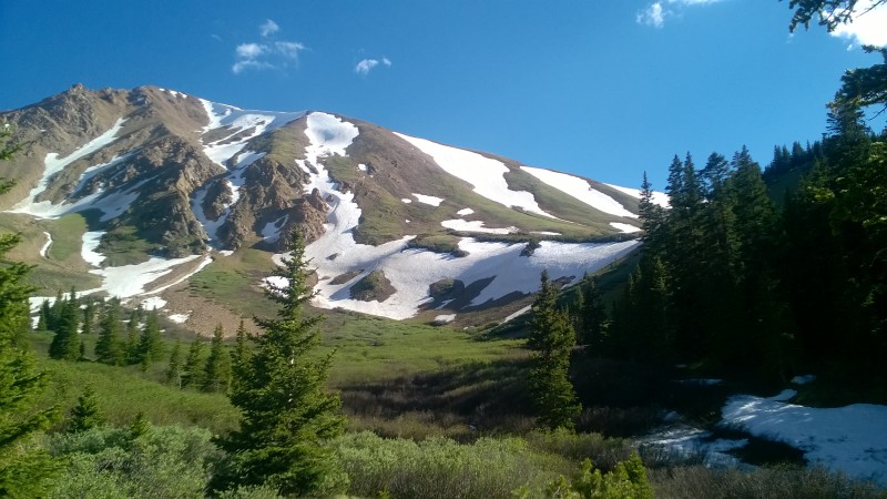
First look
I approached up grassy slopes between the two snow fields on the mid-upper right on that photo.
Once up on that ridge - there is a pretty dang large shoulder left to climb of Parnassus. Once up there I saw lone figure climbing the Woods Mtn - likely from Herman's Gulch (aka "Herman's Head") - which I myself did a long time ago.
BUT - this way towards Woods and/or Parnassus is way better - you have no notion about I-70 until you're taken that ridge - everything back in the valley is full Serenity.
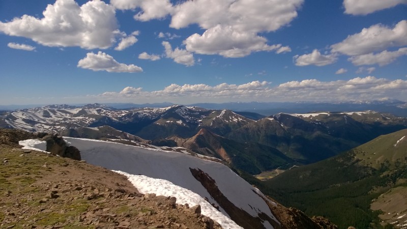
The view from Parnassus is quite commanding too - full sweep of northern CO - including Flattops; plus practically all of Gores - hints of Elks - and sweeping views of Northern Sawatch and Ten Mile Ranges.
Cap it off with Epic boot ski down that large snowfield (the one on the left of the approach photo) - and you got yourself a good Sunday. Good thing no weather that afternoon too!
overall mileage (estimated) is 5-6 miles from the road. Took me from 2:15pm - 6:20pm or so.
Started at the gate with ominous signage
(there was a more overgrown road a notch further up the road that someone else was parked at - but I have no idea where that road went as it never seemed to catch up with my route)
Thumbnails for uploaded photos (click to open slideshow):
That IS a fun route in a beautiful valley, isn't it? Last time I was up that way (several years ago), there was a sign a mile or so before the sign in your TR that says it's private property for the next xx miles. I always parked at that sign cuz I was afraid my truck might get towed and probably added a couple unnecessary miles to the trek. Obviously, you had no trouble parking where you did. Thanks for bringing back some fond memories. Nice pics!!
Caution: The information contained in this report may not be accurate and should not be the only resource used in preparation for your climb. Failure to have the necessary experience, physical conditioning, supplies or equipment can result in injury or death. 14ers.com and the author(s) of this report provide no warranties, either express or implied, that the information provided is accurate or reliable. By using the information provided, you agree to indemnify and hold harmless 14ers.com and the report author(s) with respect to any claims and demands against them, including any attorney fees and expenses. Please read the 14ers.com Safety and Disclaimer pages for more information.
Please respect private property: 14ers.com supports the rights of private landowners to determine how and by whom their land will be used. In Colorado, it is your responsibility to determine if land is private and to obtain the appropriate permission before entering the property.


 First look")
")
")
")
")
")
")
")


