| Report Type | Full |
| Peak(s) |
El Diente Peak - 14,175 feet Mt. Wilson - 14,256 feet |
| Date Posted | 06/05/2017 |
| Date Climbed | 05/28/2017 |
| Author | Psemin42 |
| Additional Members | bobalob |
| El Diente to Mt. Wilson Traverse |
|---|
|
There are mountains that you climb that when you get to the summit you are relieved and the stress of the day is behind you. Then there are mountains that when you get to the summit there is a nagging thought in the back of your mind on just how exactly you will get down. These two mountains fall into the latter category. A multi-day trip down to these mountains have been on my radar for the past year and soon a Memorial Day Weekend trip was on tap. There was a group of 3 of us that decided to take on the long, but far from boring, 7 hour drive to the Wilson Group. We all had to work on Friday so the plan was to head out around 6pm from Denver and get a few hours of sleep by the car before hiking in on Saturday. As with almost all trips, our departure time was far from punctual. We ended up stopping in Morrison for a âquickâ dinner before hitting the open road. But after a 2 hour meal that included one of the most entertaining interactions with a waitress we were finally on the road at 9pm. After 7 hours of red bull, road side dance parties and numerous Karaoke sessions that included âI Want To Know What Love Isâ and âRockin' Robinâ we finally hit the turn off for the trailhead. About 3 miles into the road some snow drifts started to show up and soon the road became impassable. As it was getting close to 4am and distraught about having to hike an additional 4 miles in the morning we retreated to a flat parking spot and setup to bivy. Before we knew it the sun was up, but there was no movement within the group until 10am. All things said and done we finally hit the trail around 12pm with a little over 8 miles to Navajo Lake. The road up to the Kilpacker Trailhead is still covered in deep drifts an impassable by all vehicles outside of ATVs (we had to help dig out a lifted Wrangler on the way back). Once you hit the Kipacker Trailhead the road becomes bone dry and you start to descend 700' in about a 2 mile stretchâ¦was really not looking forward to going back up that on the way back. 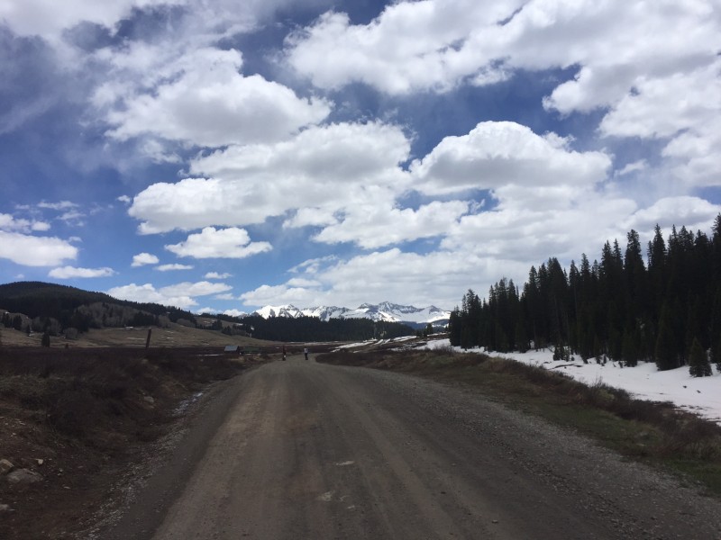 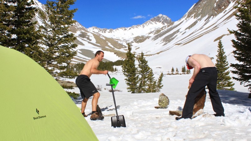 The wind Saturday night in the basin was unbelievable, deterring both sleep and thoughts of a traverse the following morning. Alarms went off at 4am with substantial gusts continuing to blow through camp. After a quick pow-wow we decided to sleep an extra 30 minutes and hope the wind would slowly subside as the sun came up. Right on que, the 4:30 alarm spelled the end of any additional gusts and 45 minutes later we were packed and heading to the North Face couloir to El Diente. The snow had gotten an awesome freeze the night before and we were at the base of the couloir as the sun was coming over Gladstone peak. With our luck, the bomb proof snow became ankle deep crusted powder a little over a quarter of the way up. Using the classic flying goose technique we each took turns at the point making a stairway to heaven for the rest of the group. The couloir became pretty steep towards the top, probably hovering around 45 degrees for the final pitch to the right of the headwall. We topped out of the couloir and that's when we knew that the easiest part of the day had just ended. 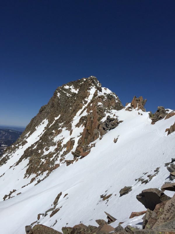 The North Face couloir tops out a lot farther East on the El Diente â‘ Mt. Wilson ridge than I had originally had thought and the remaining ridge looked like no small task. 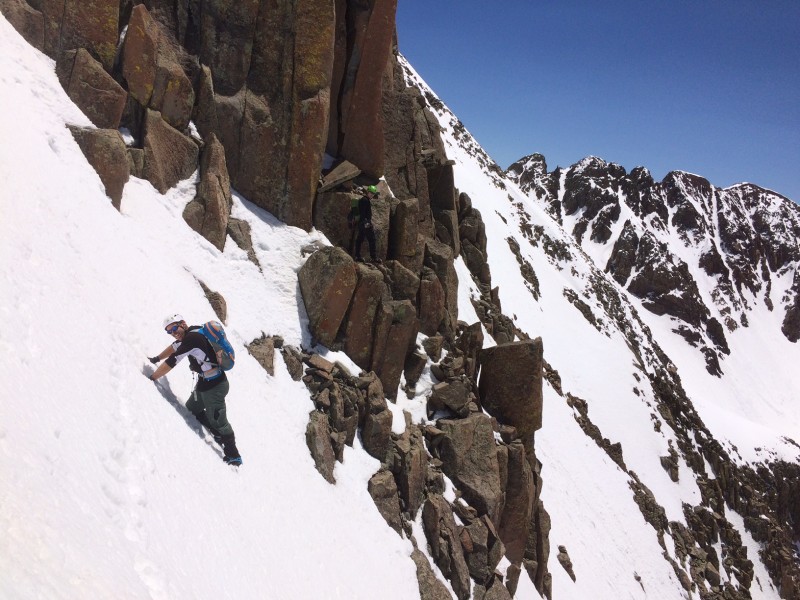 The remaining ridge traverse appeared daunting and all three of us were not looking forward to the continuous snow traverses and down climbs. Due to the snow traverses we opted to keep our crampons on while we scrambled and climbed over the rock, making it a little more sketchy than it needed to be. We dropped down some steep snow on the South side in order traverse around the gendarmes that included a very airy rock step over a cliff. We finally reached a long stretch of snow covered ridge and were able to finally tackle some mileage without too much of a hassle. From this point on, the rock climbing challenges really began. In order to avoid some additional snow traverses we stayed on the ridge crest which made for easy route finding but increased the exposure. After dropping into the prominent saddle we did the look around trying to find the easiest way upâ¦âThat way? No. How about that way? No. I guess this way? Sure.â. The ascent up from the saddle provided the most technical and challenging climbing of the day outside of the crux move right below the summit. Of course we were still rocking some crampons so that didn't make it any easier. Once up from the saddle we finally decided to take off the crampons and the climbing became a lot more stabe and secure (who would have guessed!). But of course after some class 3 exposed climbing we came to a steep snow covered ridge; not wanting to mess with the crampons we straddled the ridge and did a kick step descentâ¦one of the sketchiest down-climbs I have ever done. From there the group split into two in order to take the route we felt most comfortable on. 1 guy took one of the most exposed rock âbutt scootsâ across a rock ridge while myself and another took a snow traverse of 60-65 degree snow to a short couloir up to the small saddle just below the summit. 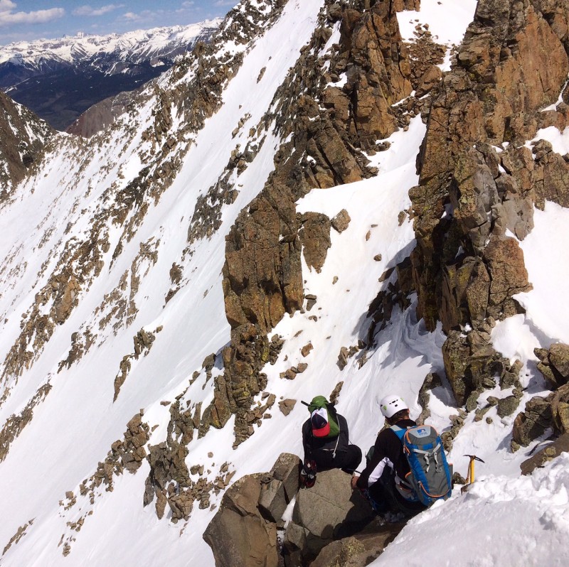 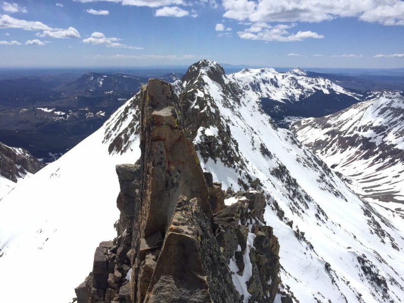 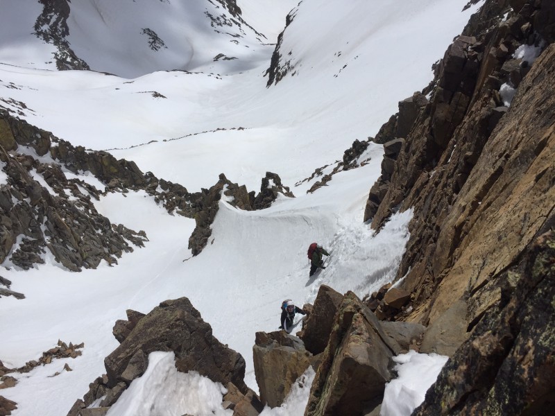 From there the crux of the route, in my opinion, lied in wait. The move included a full spread eagle up onto a rock while you peer over one vertical slope and feel the wind between your legs from the other vertical slope. You need to have full confidence in yourself in this move or you might be sitting there staring at the long sought after summit wondering what could have been. After 5.5 hours, multiple wardrobe changes, sketchy rotten snow traverses and a whole lot of âHow does it look?â we finally hit the summit. We took some summit shots and watched a group of two strap into their skis for a descent of the Box Car Couloir, still on my list to do! After some much needed R&R we were back at the summit crux trying to figure out how to get down. We took the descent down Mt. Wilson's North Slope, which included some down-climbing through some rotten snow and rocks until we reached the couloir. Exhausted from the day and going on 11 hours we decided it was time to tighten the helmets and go for a ride. After giving out some Rad calls we were carving the mountainside from our backsides. With the right amount of control and steering it was almost a continuous 2,000' glissade! I think you can see our line!  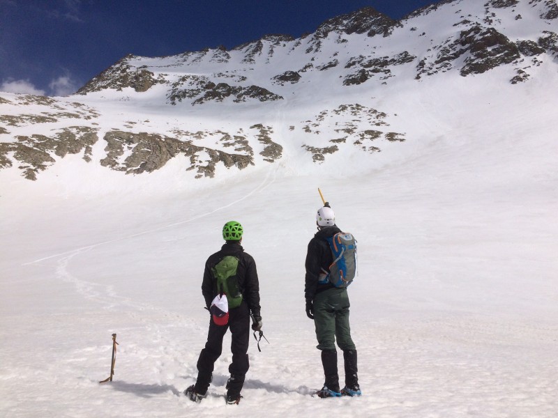 From the upper basin we hiked back down to the lake and exhaustedly hopped into bed about 8pm. Our original plan was to attempt Wilson Peak the following day but following the mentally and physically demanding day before we decided to sleep in and just focus on the 8.5 mile hike out and snag Wilson Peak when we came back for the Box Car Couloir. As tradition dictated we hit the road straight to Telluride for some often fantasized PIZZA! After demolishing some garlic bread in approx. 45 seconds we each ordered a medium pizza to the surprise of the waitress. I don't really know how to describe the scene that went on in the corner of Brown Dog Pizza, but lets just say the meal for 10 stood no chance against the 3 of us. As the 3 empty pizza trays sat at the edge of the table we had to ask the waitress how she felt about what she just witnessed. Although I am sure any physical attraction she had for us was now gone she did state that she had gained some respect for us! There is no better feeling than trying to make up for the caloric deficit that comes from backpacking and 14er trip. 6 hours later we were home, could not have asked for a better Memorial Day Weekend. As I type this trip report from Memorial Day Weekend I wanted to take the time and give a shout out to all of our Nation's military as well as my best friend/climbing partner, Bobalob, who has taken the oath to help protect this country and has joined the U.S. Navy as an officer and pilot! We are all able to enjoy the freedom of these mountains because of you guys, thank you! Thumbnails for uploaded photos (click to open slideshow):
 Summit of El Diente looking across the traverse")
 Summit of El Diente")
 Summit of Mt. Wilson")
|
| Comments or Questions | |||||||||
|---|---|---|---|---|---|---|---|---|---|
|
Caution: The information contained in this report may not be accurate and should not be the only resource used in preparation for your climb. Failure to have the necessary experience, physical conditioning, supplies or equipment can result in injury or death. 14ers.com and the author(s) of this report provide no warranties, either express or implied, that the information provided is accurate or reliable. By using the information provided, you agree to indemnify and hold harmless 14ers.com and the report author(s) with respect to any claims and demands against them, including any attorney fees and expenses. Please read the 14ers.com Safety and Disclaimer pages for more information.
Please respect private property: 14ers.com supports the rights of private landowners to determine how and by whom their land will be used. In Colorado, it is your responsibility to determine if land is private and to obtain the appropriate permission before entering the property.


